ie w c o u n t y
Background Report
ii | Rocky View county
Conrich Area Structure Plan – Background Report
Produced By Melissa Ayers for Rocky View county - July 2013Table of Contents
Introduction 1
Policy Context 1
Growth Management Strategy 1
Municipal Development Plan 2
Intermunicipal Context 3
Population 4
Existing Conditions 5
water And wastewater 6
Conrich Community Development Strategy 7
Study Area 7
Land use concept 8
infrastructure 9 Potable water 9 wastewater 10 Stormwater 10 transportation 11 Summary 11
Introduction
the purpose of this report is to provide an overview of the issues affecting the conrich area to prepare a new area structure plan that will guide future planning and development of the conrich area.
Planning in the conrich area is currently governed by the calgary-chestermere corridor Area Structure Plan which was adopted in 2004. Several factors affecting that area have occurred since that plan was adopted including:
• A portion of the plan area has been annexed to both calgary and chestermere.
• the canadian national Railway (cn) moved their Logistics Park to several quarter sections north of the Hamlet of conrich.
• A portion of township Road 250 (Mcknight Blvd.) is to be upgraded to four lanes which require additional rights-of-way.
• upgrades to Highway 1 are required including two future interchanges and road extensions in order to serve conrich from the south.
• the Shepard Regional Drainage initiative by Rocky View county, the city of calgary and the
Town of Chestermere identifies the need to appropriately address stormwater management on a
regional scale.
• water and wastewater infrastructure are now available in the conrich area.
in order to address the changes to the conrich area and to determine the feasibility of undertaking a new area structure plan, the county completed the conrich community Development Strategy.
This strategy defined a wide study area in order to understand the comprehensive planning and
infrastructure needs for the conrich area that resulted from several large development approvals. the
infrastructure studies for the Conrich area provide co-ordination and efficiencies between approved
developments. these studies were already necessary in light of recent approvals, but were expanded using a logical land use scenario based on those approvals. the land use scenario and the information provided in the infrastructure studies are conceptual only and will not form the boundaries and land use plan yet to be developed for a new area structure plan.
Policy Context
Lands in Rocky View county receive land use and development guidance from a number of municipal documents. these provide the policy context for the conrich area. A brief summary of the impacts of these documents is provided below.
GRowTh MAnAGEMEnT STRATEGy
In 2009, the County completed the Growth Management Strategy to define growth areas within the County. Conrich was identified as a growth area, referred to as a growth node.
Growth nodes are to be the focus of population and community amenity features to ensure the
development of high quality character developments. Only five growth nodes are identified in the
Strategy so that populations are concentrated, communities become complete, and improved
infrastructure efficiencies can be realized.
the Growth Management Strategy sets a population build-out for each growth node at 10,000. this is the minimum population required to create a live-work-play environment, develop support services such
2 | Rocky View county
as significant recreational facilities (i.e. indoor swimming pools and/or arenas), and some form of local
and regional public transit.
Growth nodes such as conrich are to contain a village center, a well designed public realm, innovative transportation systems that focus on the multi-modal transport, and a diversity of housing options. in 2012, the Reeve’s task Force, a 17 person committee formed to discuss growth issues in the county, produced a public discussion paper to inform the new county Plan that is underway. in that discussion paper, conrich is presented to the local population as a complete rural community that includes a hamlet core with residential, commercial and public amenities. in addition to serving the
local population, the Conrich area was identified as providing regional and national business services, office space, and commercial and industrial development. The proximity to Highway 1 also allows for
providing commercial services to the travelling public.
MunICIPAl DEvEloPMEnT PlAn
Rocky View’s Municipal Development Plan was adopted by council in 1998, but is currently being revised and will be known as the county Plan in the future. until the county Plan is adopted, the current Municipal Development Plan provides guidance for all Area Structure Plans.
the Plan views hamlets as an integral part of the municipal settlement pattern, as they serve as a community focus for rural residents. they also act as service centers with potential to offer a wide range of community facilities for surrounding residents.
the Plan supports the development of area structure plans in areas where residential development is the emerging dominant land use and there is on-going growth pressure, which enables them to guide future growth and change in these areas.
The Draft County Plan, which will replace the existing Municipal Development Plan, has identified the
conrich area as:
• a high growth hamlet
• a regional business centre located at the Hamlet of conrich
Intermunicipal Context
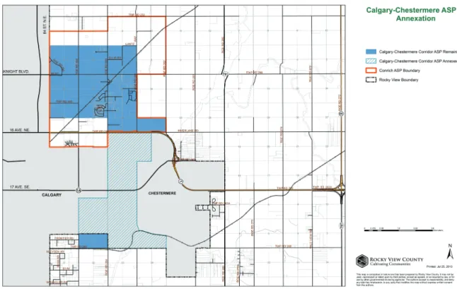
The existing Calgary-Chestermere Corridor Area Structure Plan has been significantly reduced by
annexations to both the city of calgary in 2007 and the town of chestermere in 2009, as shown in Figure 1: calgary-chestermere corridor Area Structure Plan and Annexation. Annexations to the city of calgary and the town of chestermere were meant to provide a 30 year land supply for those municipalities. it is not expected that annexations to either will occur again in the near future. As a result of those annexations, only a portion of the existing area structure plan remains in Rocky View county, which is one reason why the conrich area requires an updated plan to guide growth.
Figure 1: Calgary-Chestermere Corridor Area Structure Plan and Annexation
The Rocky View County/City of Calgary Intermunicipal Development Plan establishes an area of mutual interest to minimize land use conflicts across municipal borders, provide opportunities for collaboration
and communication, and outline processes for the resolution of issues that may arise within the plan
area. The Intermunicipal Development Plan identifies growth interests of each municipality. The Conrich area is identified as a growth interest for the County.
Development in the conrich area is not anticipated to raise any irresolvable concerns for the city of calgary. Some topics that the city of calgary is likely to want addressed through a plan for the conrich area include:
• north-south road connections in the area south of Highway 1.
• interface treatment along Highway 1 that encourages aesthetics.
• user-pay charging for amenity use and development.
• Area-wide drainage impacts and co-ordination of drainage systems.
4 | Rocky View county
Following the annexation with the town of chestermere, the town of chestermere and the county are in discussions regarding an intermunicipal Development Plan; however, no plan has been adopted at the time of this report.
Development in the conrich area is not anticipated to raise any irresolvable concerns for the town of chestermere. Some topics that the town of chestermere is likely to want addressed through a plan for the conrich area include:
• Impacts on the Town’s soft services such as fire services, policing, and school. • the use of the town’s recreational facilities by Rocky View county residents.
• Increased traffic, specifically increased truck traffic from the Logistics Park. • compatibility of uses and transitions along the border.
• economic competition
• information sharing between municipalities.
Population
A census is currently underway for the county; however, it will not be available for analysis for this report. therefore, census information from 2001 and 2006 has been used to identify past growth rates and future projections.
Growth rates in the conrich area have been one of the highest in the county between 2001 and 2006, as shown in Figure 2: change in Rocky View county Population (2001-2006), with a growth rate greater than 5.2 per cent. Given the continued high growth rates for calgary and chestermere, as well as the re-location of the cn Logistics Park, it is expected that the conrich area will continue to experience growth pressures for both residential and commercial development.
Data Source: 2006 Census CSD and DA boundaries, and RNF. Map Projection: NAD 83, UTM Zone 12, Modified Central_Meridian at -114. Created By: Western Region & Northern Territories, Statistics Canada Date: July, 2008 5.2% TO 29.8% 2.6% TO 5.1% 0.9% TO 2.4% NO GROWTH (0.0%) -0.2% TO -2.5% -4.1% TO -9.4% 3.5% 11.2% 16.0% -0.4% -0.2% 2.2% -0.4% 1.8% 2.3% -0.5% 1.0% -0.2% 11.2% -4.1% 22.6% 22.6% -0.4% -0.4% -9.2% -5.2% -0.9% 2.6% -4.6% -2.4% 0.0% 0.0% -2.0% 0.9% 4.8% 4.8% -1.6% -5.6% -1.2% -2.5% 0.0% 2.9% 5.2% 9.0% -4.8% 3.4% -0.9% 2.4% -1.1% -1.0% 29.8% 5.1% 2.0% -0.8% 3.5% 19.6% 17.8% 19.6% 17.8% 21.9% -9.4%
Conrich Area
Figure 2: Change in Rocky view County Population (2001-2006)
Existing Conditions
A variety of land uses are present within the conrich area, with residential and agricultural uses dominating. the area has a slightly rolling topography with numerous wetland areas. the Hamlet of conrich is located southeast of the intersection of Mcknight Boulevard and Range Road 284. the hamlet encompasses only a small portion of the residential development within the conrich area. existing residential development is comprised exclusively of single family dwellings, with the exception
of the Prince of Peace senior citizen’s housing development. Lot sizes range from a quarter acre, in
cambridge Park (South conrich) development, to more typical country residential lots of two to 10 acres throughout the hamlet area and in several small clusters throughout the wider area.
Business development in the conrich area prior to the development of the cn Logistics Park was limited to: home-based businesses; a small campground, and Recreation Vehicle storage area adjacent to Highway 1; and, the gas station at Mcknight Boulevard and conrich Road. Remnant lands within
the City of Calgary adjacent to Stoney Trail contain a variety of industrial/business uses, including
recreational vehicle storage and heavy equipment sales.
there are currently two schools and two churches within the study area. the khalsa School is located within the Hamlet of conrich and the chestermere christian Fellowship church is located in the vicinity of the hamlet. the Prince of Peace development also has an associated church and school. the chestermere Recreation centre located in the town of chestermere is a shared facility with
6 | Rocky View county
Rocky View county. the chestermere Recreation centre has: two ice rinks; a curling rink; three ball
diamonds; three soccer fields and a lounge.
within the conrich area, approximately 2,000 acres have been developed or approved for residential purposes and 850 acres, including the 680 acre cn Logistics Park, have policy or land use approval for business uses. in addition to existing development the following policy documents have been approved to guide future redesignation, subdivision and development within portions of the study area:
• South conrich conceptual Scheme
• Buffalo Hills conceptual Scheme
• cn Logistics Park Master Site Development Plan
in addition to the developments currently in place or being built, several proposals have been made to the county. these developments have not yet received approval, but will form part of the discussion for the area structure plan.
wATER AnD wASTEwATER
the conrich area is part of a larger regional network of piped infrastructure for both water and wastewater servicing, as shown in Figure 3: existing water and wastewater infrastructure in Rocky View county.
Drinkable water is piped from the Graham creek water treatment Plant south to the conrich area. Drinkable water has currently been allocated to the Prince of Peace development south of Highway 1.
Wastewater infrastructure is part of the East Rocky View Wastewater Transmission Main which flows from the Balzac area north of Conrich, south to the Langdon Wastewater Treatment Plan. Allocation for
the capacity of the wastewater transmission main has not yet been determined.
Conrich Area Structure Plan Background Report
7 Wastewater infrastructure is part of the East Rocky View Wastewater Transmission Main which flows from the Balzac area north of Conrich, south to the Langdon Wastewater Treatment Plan. Allocation for the capacity of the wastewater transmission main has not yet been determined.
Figure 3: Existing Water and Wastewater infrastructure in Rocky View County
C
ONRICH
C
OMMUNITY
D
EVELOPMENT
S
TRATEGY
As a result of growth pressures in the Conrich area, the County initiated a Community Development Strategy in 2010 to determine what options are possible for future development. With several development approvals, it was significant to identify what opportunities exist for infrastructure co-ordination in order to achieve efficiencies. Therefore several studies to analyze existing and future infrastructure were commissioned.
To maximize the benefit to the County, the study area for the infrastructure studies was expanded beyond the boundaries of existing or approved development to assess the wider area. A conceptual land use scenario was required for lands that were not already developed or approved for development. This scenario was a logical extension of those existing approvals and development, and known infrastructure upgrades such as road widening and interchanges. The rationale for the study area and land use concept and the options of infrastructure efficiencies is provided below.
Study Area
The study area for the Conrich Community Development Strategy was centered on the Hamlet of Conrich and encompasses 58 quarter sections for a total of approximately 3,755 hectares (9,280 acres), as shown in Figure 4: Conrich Community Development Strategy
Clean Water Infrastructure Wastewater Infrastructure
Conrich Community Development Strategy
As a result of growth pressures in the conrich area, the county initiated a community Development Strategy in 2010 to determine what options are possible for future development. with several
development approvals, it was significant to identify what opportunities exist for infrastructure co-ordination in order to achieve efficiencies. Therefore several studies to analyze existing and future
infrastructure were commissioned.
To maximize the benefit to the County, the study area for the infrastructure studies was expanded
beyond the boundaries of existing or approved development to assess the wider area. A conceptual land use scenario was required for lands that were not already developed or approved for development. this scenario was a logical extension of those existing approvals and development, and known
infrastructure upgrades such as road widening and interchanges. the rationale for the study area and
land use concept and the options of infrastructure efficiencies is provided below.
STuDy AREA
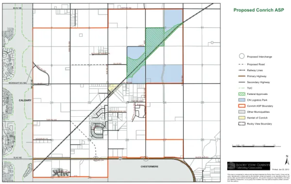
the study area for the conrich community Development Strategy was centered on the Hamlet of conrich and encompasses 58 quarter sections for a total of approximately 3,755 hectares (9,280 acres), as shown in Figure 4: conrich community Development Strategy Study Area. the study area was intended to begin a review of possible land uses and infrastructure requirements for the area. the rationale for the study area includes:
• the CN Logistics Park due to its influence on the area;
• existing development, including the Prince of Peace development, and approved development plans (conceptual Schemes) located south of the hamlet;
• extension of the study area to border the city of calgary to the west to address transition and compatibility issues with the city;
• a south border with the town of chestermere to assess transition and co-ordination with these municipalities; and
8 | Rocky View county 3 2 4 6 5 7 8 9 27 30 29 28 26 11 31 20 34 19 32 33 10 35 23 TWP RD 245 TWP RD 250 LANTZ W AY MEADOW RIDGE DR MCKERVEY PL ELLIS RD BUFF ALO H IL LS CM BUFFALO H ILLS W Y TWP RD 252 HWY 1 E/B HWY 1 INVERLAKE RD TWP RD 244 R G E R D 2 82 PLEASANT RANGE PL LUTHER ROSE BV TWP RD 245A PARK DR 84 ST R G E R D 2 83 RGE R D 290 RG E RD 2 84 RG E RD 2 85 1 CHESTERMERE CALGARY 16 AV NE MCKNIGHT BV NE 80 AV NE CA LIFO RNIA BV N E LA G U N A W Y N E CORAL SPR ING S BV N E DEL RAY RD N E 84 ST N E 0 0.2250.45 0.9 1.35 1.8 Kilometers Proposed Interchange Proposed Road Railway Lines Primary Highway Secondary Highway TUC Federal Approvals CN Logistics Park Conrich ASP Boundary Other Municipalities Hamlet of Conrich Rocky View Boundary
Proposed Conrich ASP
This map is conceptual in nature and has been prepared by Rocky View County. It may not be used, reproduced or relied upon by third parties, except as agreed, or as required by law, or for use by other governmental reviewing agencies. The authors accept no responsibility, and deny any liabilities whatsoever, to any party that modifies this map without express written consent from the authors.
Printed: Jan 30, 2013
Figure 4: Conrich Community Development Strategy Study Area
the boundaries for a new conrich Area Structure Plan may differ from the study area shown above.
lAnD uSE ConCEPT
the following Land use concept map, shown in Figure 5, was developed to provide some basic information for possible growth to investigate infrastructure opportunities. the concept is based on existing or known land uses, land subdivision patterns, transportation networks, and servicing. this map provides a broad delineation of uses and is conceptual in nature. A brief overview of the land use concept is as follows:
• The majority of the areas that are currently agriculture are identified as mixed use to allow for as much flexibility as possible and not to assume how those areas will develop.
• The blue areas have been identified as industrial because they are already zoned for the CN
Logistics Park, which will have impacts on adjacent lands.
• The yellow areas are identified as residential because most are already zoned as such. This
portion of the map includes the Hamlet of conrich. existing Rocky View policy supports
densification of existing residential prior to expansion of residential to other areas.
• the red area is already approved for commercial uses in the Buffalo Hills conceptual Scheme.
• the boundaries between the different areas are based on the existing or known future transportation network including roads and rail lines.
84 S T. N .E . 16 AVE. NE. McKNIGHT BLVD. 3 2 4 6 5 7 8 9 18 27 30 29 28 14 16 26 17 15 11 31 20 34 19 32 33 10 35 23
HWY 1 HWY 1 E/B TWP RD 252 TWP RD 250 RG E R D 2 82 R G E R D 2 85 R G E R D 2 84 R G E R D 2 83 LANTZ WAY TWP RD 245 TWP RD 243A INVERLAKE RD 84 ST 1-1 RGE RD 290 G A R D E N R D TWP RD 244 ABBEY RD MCKERVEY PL TWP RD 245A S U N S H IN E R D TWP RD 244A PARK DR LO G IS TI C S P A R K W AY M E A D O W R ID G E R D TWP RD 244B PLEASANT RANGE PL RGE R D 28 3A HWY 1 1:30,000 SCALE
© 2012 Rocky View County Printed August, 2012
CONRICH: 50 YEAR LAND USE CONCEPT Working Map for Engineering Studies
August 2012
Information as depicted is subject to change, therefore Rocky View County assumes no responsibility for discrepancies after date of printing.
LEGEND
INDUSTRIAL (distribution & warehousing)
Development is not anticipated until the 20 - 50 year time horizon in hashed out portions. These areas may experience limited growth in the short-term.
Land uses identified on the map are anticipated and unconfirmed land uses only. They are subject to change.
NOTES
CN CALGARY LOGISTICS PARK RESIDENTIAL GROWTH AREA
MIXED USE STUDY AREA #2
(transitional - residential, institutional, commercial, recreational, light business industrial)
MIXED USE STUDY AREA #1
(transitional - residential, institutional, commercial)
MIXED USE STUDY AREA #3 ( residential and or business industrial)
COMMERCIAL
INTERMUNICIPAL STUDY AREA PRINCE OF PEACE
(intensification and expansion of existing developmentl) MIXED USE STUDY AREA #4
(highway frontage commercial, recreational, residential) MIXED USE STUDY AREA #5
(recreation, business, commercial)
LIMITED DEVELOPMENT POTENTIAL PROPOSED ROAD PROPOSED INTERCHANGE 1 3 5 6 9 8 13 14 11 4 2 10 12 16 15 17 18 19 20 21
Figure 5: Conrich Community Development Strategy land use Concept
InFRASTRuCTuRE
As part of the conrich community Development Strategy, four studies were commissioned by the county to understand how infrastructure of existing, approved, and future development could be
co-ordinated with the possibility of identifying efficiencies. The information provided in these studies identifies the existing situation and future opportunities, but does not determine policies for a new
conrich Area Structure Plan.
ClEAn wATER
Alberta environment has approved the transfer of a portion of the western irrigation District’s water license to Rocky View county and a regional water line has been constructed that brings water from the Graham creek water treatment Plant.
Rocky View County has entered into an agreement with CN Rail to construct the first phase of the
water system to conrich. this system was constructed by Rocky View county and funded by cn. cn’s
costs will be recovered through a cost recovery scheme that requires benefitting lands to contribute
proportionately to the construction costs.
the details of the local distribution system will be established in water Servicing Studies prepared for individual applications or development areas. construction of the local distribution system will be
undertaken by benefitting developers. Once the water system is operational it will be managed by the
10 | Rocky View county
co-ordination of these local systems is explored in the conrich water Distribution network Study commissioned by the county as part of the community Development Strategy. this study proposed three key elements (shown in Figure 6: conrich community Development Strategy Potable water infrastructure at the end of this report) including:
• A network of water mains ranging in diameter from 250 millimetres to 600 millimetres;
• two future reservoir and pump stations with a combined total of approximately 24,000 cubic metres storage and 1,000 kilowatt (1,500 horsepower) pump capacity;
• Three pressure zones.
wASTEwATER
conrich is part of a larger regional system in Rocky View county consisting of the east Rocky View
Wastewater Transmission Main. This system conveys wastewater from the Balzac area to the Langdon
wastewater treatment Plant. Allocation of the capacity of this line between different areas in Rocky View county, including the conrich area, has not been determined.
the conrich wastewater Servicing Plan which forms part of the community Development Strategy included several conclusions and recommendations (shown in Figure 7 at the end of this report) including:
• A series of gravity mains are proposed to be installed in the conrich area to convey wastewater to lateral lift stations to tie into the regional system.
• At full build-out (year 2060), the plan area will require an additional six lateral lift stations with force mains.
• Area residents that currently are on septic field systems should be connected to the regional system once available. Septic fields should be abandoned as per Alberta Environment and
Sustainable Resource Development (eSRD) guidelines.
• Areas where there is existing wastewater infrastructure (cambridge estates Area) are proposed
to be the first areas for development followed by approved developments (Buffalo Hills, CN). • An upgrade to the Langdon Wastewater Treatment Plan will be required to handle peak flows.
SToRMwATER
Conrich is part of the Shepard sub-basin which flows to the Bow River Basin. The topography is fairly flat with few defined drainage courses. As in most parts of the County, much of the existing
development has adopted rural stormwater management practices, incorporating culverts, ditches, and natural conveyance systems.
Regionally, a Shepard Regional Drainage Plan is currently being produced in collaboration with the city of calgary and the town of chestermere. Due to the area’s poor drainage the three municipalities have
been collaborating on a solution that would benefit the entire sub-basin. The solution would convey
stormwater to the Bow River, which is approximately ± 32 kilometres (± 20 miles) south of the conrich area. A drainage canal to the Bow River would require co-ordination between the three municipalities
and significant resources to complete. Any planning in the area should protect drainage routes leading
to a drainage ditch to facilitate a potential future connection.
Locally, any development, including low density residential areas, has environmental impacts downstream and therefore any future planning or development must consider this, especially in the
the Master Drainage Plan, as part of the community Development Strategy, suggests implementing
low impact development techniques with adequately sized wet ponds and/or wetlands that allow for
storage and evaporation. Furthermore, development should be located with appropriate setbacks to not adversely affect the existing drainage system.
TRAnSPoRTATIon
existing development approvals in the conrich area have resulted in upgrades to the transportation
network. These upgrades specifically enhance pre-determined haul routes to and from the CN Logistics Park as well as traffic flows resulting from an increase in population to and from Highway 1.
Specifically, the Conrich Transportation Network, part of the Community Development Strategy,
includes the following upgrades:
• Mcknight Boulevard from the interchange at Stoney trail to Range Road 284 from a two lane road to a six lane road.
• the extension of Mcknight Boulevard from Range Road 284 to Range Road 283 from a two lane to a four lane road.
• Range Road 284 from a two lane road to a four lane road between Mcknight Boulevard and country Hills Boulevard.
• Range Road 285 from a two lane road to a four lane road between Highway 1 and Mcknight Boulevard.
• 96 Avenue from the interchange of Stoney trail to Range Road 284 from a two lane road to a four lane road.
SuMMARy
The Conrich area has experienced a significant amount of growth and changes since the adoption
of the calgary-chestermere corridor Area Structure Plan in 2004, which warrants the development of a new area structure plan. this growth includes several approved residential and non-residential developments such as the cn Logistics Park and the Buffalo Hills conceptual Scheme, annexations to the city of calgary and town of chestermere, changes to the transportation network and the introduction of piped servicing.
An assessment of existing and approved developments occurred as part of the conrich community
Development Strategy which identified a conceptual land use scenario and opportunities to coordinate and maximize infrastructure efficiencies. The information from the Community Development Strategy
was developed to identify opportunities that will form part of the discussion for the development of a new conrich Area Structure Plan.
12 | Rocky View county
Conrich Area Structure Plan Background Report
13
Conrich Area Structure Plan Background Report
Conrich Area Structure Plan
Background ReportRocky View county | 911–32 Avenue ne, calgary, AB t2e 6X6