Warrenton
Parks Master Plan
FINAL DRAFT PLAN
September 2010
ACKNOWLEDGEMENTS
The City of Warrenton appreciates the contributions and input of individuals involved in this project including: City Staff, the Warrenton Parks Advisory Board, the
Warrenton Trails Association, the Warrenton City Commission, and residents who participated in the community workshops.
CITY STAFF
Robert Maxfield, City Manager
Nancy Claterbos, Public Works Secretary Craig Walter, Public Works Foreman
Carol Parker, Community Development Director
WARRENTON CITY COMMISSION
Gilbert Gramson, Mayor Mark Kujala, Vice-Chair Terry Ferguson
Frank Orrell Karl R. Hellberg
WARRENTON PARKS ADVISORY BOARD
Bill Berg, Chair Jill Benish Barry Smith Mary Blake Richard Johnson Sharon Anderson
WARRENTON TRAILS ASSOCIATION
Jim Scheller, Chair Barbara Linnett
PROJECT TEAM
This plan was prepared by Cameron McCarthy Gilbert & Scheibe Landscape Architects and Planners (CMGS) in association with the University of Oregon’s Community Planning Workshop (CPW):
Cameron McCarthy Gilbert & Scheibe Landscape Architects and Planners 160 East Broadway, Eugene OR 97401 P: 541.485.7385
Colin McArthur, AICP; Principal/Project Manager Brian McCarthy, ASLA; Principal
Jason Koch Bryan Belcher
Community Planning Workshop University of Oregon
1209 University of Oregon, Eugene, OR 97403 P: 541.346.3615
Bob Parker, AICP; Program Director Casey Gatz
Francesca Patricolo Stephanie Scafa
CONTENTS (CONT.)
ACKNOWLEDGEMENTS ... CONTENTS... EXECUTIVE SUMMARY...ES.1 CHAPTER 1 INTRODUCTION ... 1 1.1 Overview ...11.2 Purpose of the Plan ...1
1.3 Planning Process ...2
1.4 Community Involvement ...3
1.5 Relationship to City of Warrenton Plans ...4
1.6 Relationship to Other Plans...6
1.7 Plan Organization ...9
CHAPTER 2 EXISTING CONDITIONS... 11
2.1 Overview ...11
2.2 Regional Context & Planning Area...11
2.3 Demographic Analysis...12
2.4 Conclusions ...17
CHAPTER 3 THE PARK SYSTEM... 19
3.1 Overview ...19
3.2 Parks System ...19
3.3 Operations and Maintenance...29
3.4 Park Service Areas ...29
3.5 Level of Service Analysis ...31
3.6 Conclusions ...34
CHAPTER 4 PARK AND RECREATION NEEDS ... 35
4.1 Overview ...35
4.2 National and State Trends...35
4.3 Community Needs...38
CONTENTS (CONT.)
CHAPTER 5 PLANNING FRAMEWORK ... 41
5.1 Overview ... 41
5.2 Vision ... 41
5.3 Goals and Objectives... 41
5.5 Conclusions ... 44
CHAPTER 6 RECOMMENDATIONS... 45
6.1 Overview ... 45
6.2 System-wide Level of Service ... 45
6.3 Parkland Acquisition... 46
6.4 Parkland Development... 47
6.5 Conclusions ... 57
CHAPTER 7 IMPLEMENTATION AND FUNDING ... 59
7.1 Overview ... 59
7.2 Organizational Structure ... 59
7.3 Current Operating Budget... 59
7.4 Funding Requirements ... 62
7.5 Funding Strategy ... 69
7.6 Additional Funding Resources ... 72
7.7 Conclusions ... 74 APPENDIX A PARKS INVENTORY ...A APPENDIX B STAKEHOLDER INVOLVEMENT ...B APPENDIX C FUNDING SOURCES...C APPENDIX D DESIGN STANDARDS...D
EXECUTIVE SUMMARY
This is Warrenton’s first Parks Master Plan and it is designed to guide development of the City parks system over the next 20 years (from 2010 until 2030). A parks master plan is a long-term vision and plan of action for a community’s parks system. This plan identifies strategies and techniques for operation and development of parks, land acquisition, and funding. Through this plan, the City of Warrenton will continue improving the service and quality of its parks to meet the needs of current and future residents.The Parks Master Plan specifically delivers five planning elements:
» Provides an inventory of existing parks and an analysis of appropriate park classifications and standards;
» Identifies current and future park needs using input from the community as well as technical data;
» Includes a capital improvement plan (CIP) that enables the City to achieve its goals; » Creates a strategy for short and long-term land acquisition; and
» Identifies potential funding techniques and sources to implement the CIP.
The Executive Summary highlights existing facilities, key community needs, goals and actions, park improvements and acquisitions, and the funding strategy described in the Warrenton Parks Master Plan.
Park Inventory & Assessment
Effective parks system planning requires identifying and assessing existing park facilities and amenities through an inventory process. The inventory process exposes system-wide strengths and weaknesses and reveals underserved areas and services.
Determining the activities that occur in each park, and the condition of facilities and amenities, helps guide recommendations and capital improvement programming efforts. The inventory process includes consideration and assignment of park classifications. Careful review of current and future park system needs by park classification type ensures a balanced parks system capable of efficient service to the community.
Chapter 3, The Parks System, provides a description of each park facility and an
overview of the condition of the parks system as a whole. This information is included in its entirety as Appendix A, which includes descriptions of park facilities,
opportunities, and constraints. Following is a summary table of City parks and recreation facilities and their respective classifications.
Table ES-1. Warrenton Parks
Source: CMGS/CPW, 2010.
Community Needs Analysis
The Warrenton Parks Master Plan includes an analysis and assessment of community needs based on local demographic, economic and recreation trends, as well as
stakeholder interviews and community workshops. Parks and recreation facilities are important to communities and to the residents of Warrenton in particular. Therefore, it is not surprising that many residents see opportunities for improvement in the parks system. After reviewing recreation trends, interview results, and input from the community, several key park facility needs emerged. These include the need for: » Diversity of park types and locations;
» Updated park equipment and amenities;
» Additional active and passive recreation opportunities; » Improved or additional measures to increase safety; and » Connectivity between parks.
Community Vision and Goals
The Parks Master Plan includes a long-term vision for the Warrenton Parks System, nine goals that define system priorities and specific objectives that guide
“We envision a parks system that enhances the livability of Warrenton while building our community’s health, wellness, and quality of life. Our parks system will promote social, cultural, and historical activities while providing a natural environment for the enjoyment of all residents and visitors. The City of Warrenton recognizes the boost in human and social capital parks
improvement and maintenance projects will provide its residents.”
Goal 1: Park Awareness and Outreach
Develop and implement park awareness and outreach strategies to inform residents and visitors about the parks system.
Goal 2: Safety and Access
Operate park facilities that are safe and accessible for the entire community. Goal 3: Funding and Partnerships
Evaluate and establish new mechanisms for funding existing and future park and recreation facilities while strengthening relationships between the City of Warrenton and other partners.
Goal 4: Park Maintenance and Operations
Manage and operate all sites to maintain a safe and efficient parks system. Goal 5: Parkland Acquisition
Acquire additional parkland to ensure that all areas of the city are adequately served by park facilities.
Goal 6: Parks Planning
Establish a coordinated process for parks planning, park acquisition, and development that involves residents and community groups as well as the Parks Advisory Board and the City staff.
Goal 7: Amenities and Design
Design and manage City parks to provide an attractive, pleasing, and enjoyable environment for residents.
Goal 8: Community Events
Develop community event areas within Quincy and Bessie Robinson Community Park and Seafarer’s Park to provide opportunities for community cultural and recreational events that attract large gatherings.
Goal 9: Recreation
Enhance the types of recreation opportunities to include people of differing age groups and backgrounds.
System Improvements
The Warrenton Parks Master Plan identifies system improvements as well as capital improvements for specific parks. The system improvements include new parkland acquisition and parkland development. Park specific improvements include:
» Replace outdated play equipment to reduce maintenance, increase user access, and promote user safety;
» Construct park perimeter trails in appropriate parks to improve safety and provide active recreation;
» Install dog-waste disposal stations in appropriate parks to promote sanitation and improve dog-friendliness in the parks;
» Install community gardens in appropriate parks to increase local accessibility; » Increase trail connectivity to parks to promote accessibility and use;
» Install directional and identification signage to improve way-finding and promote park awareness; and
» Improve ADA accessibility at all parks including the installation of ADA accessible surface material at existing playgrounds.
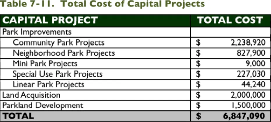
The Parks Master Plan is implemented, in part, through the Parks Capital Improvement Plan (CIP). The CIP identifies park improvements and estimates costs for the ten-year period of 2010 to 2020. Park improvements included in the CIP focus on improving access, safety, landscaping, play and restroom structures, and providing additional park amenities. The CIP is dynamic and is therefore included as a separate document that should be reviewed on an annual basis by City staff and the Parks Advisory Board as part of the City of Warrenton’s 10-year Capital Improvement Plan.
Funding
This Plan proposes three elements that constitute the majority of the City’s park expenditures over the next 20 years: the acquisition and development of new
parkland, system improvements, and operation and maintenance. Based on the costs to implement the proposed improvements, the City will need to spend approximately $6,847,090 on its parks system. Table ES-2 outlines parks system expenditures through 2030.
Table 7-11. Total Cost of Capital Projects
Source: CPW/CMGS, 2010.
Parkland development as well as community and neighborhood park improvement projects comprise the majority of the total costs. Park improvement projects total $3,347,090. Land Acquisition and parkland development total $3,500,000. The actual costs associated with the acquisition and development of new parks can be reduced through a diversified funding strategy that includes user fees, bonds and levies, partnerships, land donations, trusts, and easements.
The City should pursue a funding strategy that includes a variety of sources including grants, donations, and partnerships, as well as bonds, levies, and SDC revenues. The Plan specifically recommends the City do the following:
» Adopt and implement a Parks SDC;
» Consider a Parks and Recreation Special District;
» Pursue grant opportunities for capital improvement projects, trails, and land acquisition;
» Develop partnerships;
» Develop relationships with landowners; » Evaluate the feasibility of bond measures; and
» Explore measures to reduce acquisition, development, and operational costs.
Conclusion
Completion of this plan is an important step toward the fulfillment of the City’s parks system Vision and Goals. With careful attention, Warrenton’s parks system will continue to improve quality of life for local residents while adequately planning for the future park needs as the community grows.
CHAPTER 1
INTRODUCTION
1.1 Overview
Parks system assets - parks, open space, natural areas, and trails - are significant
contributors to a community’s quality of life. “Quality of life” is a term that has grown in popularity during the last few decades; it refers to an individual’s satisfaction with their social and physical surroundings. The term has been associated with a number of community amenities, which include trails, natural areas, open space, and parks. These amenities are assets that build strong communities by providing recreation
opportunities, gathering spaces, connectivity, natural resource protection, cultural resource preservation, and aesthetic beauty. Their functions shape the character of communities, provide anchors for neighborhood activities, and promote healthy behaviors and lifestyles.
Creating and maintaining park and recreation facilities is a challenge for service providers. Limited resources and competition for resources, both staffing and
budgetary, restricts many communities’ ability to develop and maintain parks systems. Identifying system priorities and matching them with available resources requires thoughtful planning. Communities typically develop and adopt Parks System Master Plans to guide development of parks systems.
1.2 Purpose of the Plan
The Parks Master Plan (Master Plan, Plan) establishes a vision for Warrenton’s parks system, and presents recommendations for the continued provision of quality park facilities over the next 20 years. The Plan is intended to help Warrenton build upon its unique park assets, identify new opportunities for development, and meet the needs of current and future residents.
Specifically, this Plan includes:
» An inventory of existing park and recreation facilities in Warrenton, including an analysis of park classifications and standards;
» A parks and recreation needs analysis based on technical and demographic data, as well as extensive citizen involvement - including community workshops and
stakeholder interviews;
» A twenty-year capital improvement plan (2010-2030) that identifies specific improvements for each of Warrenton’s parks with estimated project costs and target completion dates;
» A parkland acquisition strategy that identifies the amount of land needed, by park type, for the next 20 years and describes strategies for acquiring lands that are appropriate for inclusion in the parks system;
» Funding options and a funding strategy, including an overview of potential revenue sources such as Systems Development Charges (SDCs) and a Parks Utility Fee. The Plan outlines Warrenton’s vision for the parks system and provides the specific tools and components necessary to achieve that vision. For this plan to best reflect Warrenton’s current and future needs, updates are recommended every ten years. Regular updates ensure that the plan continues to be a relevant planning tool.
1.3 Planning Process
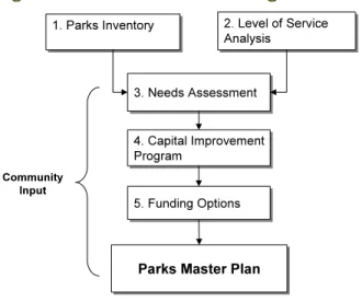
This Plan utilizes a “systems” approach for the planning process, as recommended by the National Recreation and Parks Association (NRPA). The systems approach places local values and needs first and provides a framework for creating a parks system that physically meets those values and needs. The planning process is outlined in four phases, as described below and detailed in Figure 1-1.
Figure 1-1. The Parks Planning Process
» Phase 1 – Inventory & Analysis: Inventory existing parks. Identify existing park facilities, assess general park conditions and existing improvements, and identify needed maintenance or additions.
» Phase 2 – Needs Assessment: Conduct a needs assessment. Identify key needs in the community, drawing from demographic and recreation trends and community input. Population growth, demographic characteristics and activity participation trends help identify the types of facilities needed by current and future residents. Determine level of service, usually expressed as acres of developed parkland per 1,000 residents.
» Phase 3 – Vision and Recommendations: Create a capital improvement Plan (CIP) and land acquisition plan. Using Steps 1-3, the CIP identifies capital
improvement projects for 20010-2030 and prioritizes projects for the first five years of the plan. The CIP, provided as a separate document from the Parks Master Plan, is based upon current needs. The land acquisition plan looks at the longer 20-year planning term to determine needed parkland to serve a growing population.
» Phase 4 – Implementation and Funding Strategies: Identify potential sources and methods of acquiring funds for new parkland development,
maintenance, operations, and improvements to existing parks.
» Phase 5 – Plan Refinement and Adoption: Incorporate comments and suggestions based on City staff, Parks Advisory Board, and City Commission review of Draft Plan. Prepare Final Plan for adoption by Warrenton City Commission based on recommendation by the Parks Advisory Board.
1.4 Community Involvement
Community and stakeholder involvement are critical elements of the planning process. Community involvement provides tangible benefits to the process by: (1) providing insight into residents’ values and preferences; (2) developing and nurturing an
environment of goodwill and trust; (3) building consensus support for the Plan; and (4) establishing meaningful dialogue between the public and the planners.1
The parks planning process places emphasis on the input and suggestions of residents and other stakeholders. The primary parties involved in the development of the Plan include: Warrenton residents; the Warrenton City Commission; Warrenton City Planning and Public Works Staff; the Warrenton Parks Advisory Board, and the
Warrenton Trails Association. Three primary methods for gathering community input are utilized in the development of the Plan, summarized below:
» Stakeholder Interviews: Stakeholder interviews conducted with community group leaders and organizational representatives. Interviewees identified the strengths and weaknesses of Warrenton’s parks system, and identified key means to improve upon the system.
» Community Workshops: Two workshops conducted with community members. These workshops (held at the Warrenton High School) collected information about the community’s desires and priorities for the parks system. » Parks Advisory Board Meetings: Six meetings held with the Parks Advisory
Board. These meetings provided a format for the Board to participate in the planning process, and, more specifically, to assist in the development of the park classification system and Level of Service (LOS) standard, parks system goals, and system wide improvements, including park specific improvements.
1 Cogan, Elaine. 2003. Public Participation. Published in The Planner’s Use of Information. Planners Press,
The planning process was further aided by input and direction from Public Works Department staff. This Plan combines community input with technical analysis to provide a framework for achieving both short and long-term goals and objectives that implement the community parks system vision. The Plan can also be integrated into other planning decisions that relate to areas of parks planning, such as open space acquisition, natural resource protection, cultural resource protection, and trail development.
1.5 Relationship to City of Warrenton Plans
The Parks Master Plan is one of several documents that comprise Warrenton’s long-range planning and policy framework. The following plans have bearing on the parks planning process and have been considered during the creation of this Plan:
WARRENTON COMPREHENSIVE PLAN
The Warrenton Comprehensive Plan was originally adopted on July 14, 1983 and is a guide for future community development in Warrenton. The plan complies with Oregon’s Statewide Planning Goals, was developed after careful review of the goals, and through extensive data collection.
The Warrenton Comprehensive Plan recognizes the asset that Fort Stevens State Park is for resident’s recreation as well as Camp Kiwanilong, both of which are located within the Warrenton urban growth boundary (UGB). The Comp Plan recognizes the trail system as a multimodal transportation system for residents, connecting parks, natural areas and business activities throughout the City. The Comp Plan outlines many of the goals listed in the Warrenton Trails Master Plan, including multi-user trails for bicyclists, pedestrians, wheelchairs, baby strollers, and equestrians. There are design standards listed in the plan for all future trail construction, as well as recommendations for trail features and amenities.
WARRENTON TRANSPORTATION SYSTEM PLAN
Written and adopted by the City of Warrenton in 2004, the Transportation System Plan (TSP) establishes a plan for transportation systems through the year 2022. The TSP addresses ways to improve the transportation system in a way that will emphasize the local street network and protect the function of US 101 as a statewide highway. This plan also addresses all modes of transportation, including pedestrian and bicycle. Several TSP Goals relate directly to parks and recreation facilities. Goal 1 addresses mobility, including the development of safe means for pedestrians and bicyclists to move about the city. Goal 5 expands upon Warrenton’s plan for connectivity, including the desire to “Improve public access to the waterfront and trails along the waterfront,” “Establish an interconnected trail system that connects neighborhoods, the downtown area, and the waterfront, using old railway right-of-ways where appropriate and signage to indicate trail access points,” and to “Adopt and maintain development standards that support pedestrian and bicycle access to commercial and industrial developments, including (but not limited to) direct pathway connections, bicycle parking facilities, and signage where appropriate.”
Goal 7 addresses the physical environment. This goal encourages the use of alternatives modes of transportation, the balance of transportation needs with
preserving significant natural features, and the minimization of impacts on wetlands and wildlife habitat. Safety is addressed in Goal 11, which identifies the need to improve the safe connections for bicycle and pedestrian routes in the City. The Transportation System Plan recommends off-street trail connections for several areas of Warrenton, and facilities for these connections.
WARRENTON TRAILS MASTER PLAN
Adopted by the City of Warrenton on July 7, 2008, the Warrenton Trails Master Plan was developed to assist in the creation of a network of trails that links destinations, natural features, historic landmarks, community facilities, other transportation facilities, neighborhoods, businesses, regional trails, adjacent communities, and state and federal parks. The overall goals of the Warrenton Trails Master Plan are to provide
connections for residents to recreate, increase access to the trail system, and encourage trail use by schools for science education and athletic training.
In addition to planning the improvement of the current trails, the Trails Master Plan also outlines the addition of several additional trail connections. These include Beaver Trail, which will run along Iredale Street and former logging roads between the
Hammond Post Office and 11th Street, bringing trail access to the Warrenton Soccer Fields. Creekside Trail is planned to have two different sections. A northern section of the trail will bridge King and Harbor Drive to 14th, and an eastern section,
connecting the Eastern Skipanon River Trail Spur at Highway 104 along Ensign Lane and across Highway 101.
WARRENTON URBAN RENEWAL DISTRICT PLAN
Adopted by the City of Warrenton on June 28, 2007, the Warrenton Urban Renewal District Plan was prepared to guide the provision of infrastructure necessary for the improvement and redevelopment of Warrenton. The main goal was to improve economic health, condition and appearance of the area, by providing for more attractive shopping, dining, living, working, and recreating.
Specific to parks planning, the Plan outlines goals for developing the downtown area with bike and pedestrian trails with portals and trailheads, focusing on connectivity. The plan outlines that during the second phase of the Warrenton Urban Renewal District Plan, $25,000 are to be used for tourist and bicycle directional signage. For the third phase, it provides $200,000 for restrooms, and $50,000 for additional trailheads and directional/interpretive signage.
WARRENTON DOWNTOWN-MARINA MASTER PLAN
The Warrenton Downtown-Marina Master Plan is a visionary document with the goals of encouraging high quality redevelopment, improving the area for living and working, and building a vision and theme for the city. The plan focuses on five key ideas for improving the downtown area; focusing on Natural Setting, Connect to Waterfront, Improve Pedestrian and Bike Circulation, Green Downtown, and City Leading by Example.
These five key ideas, and the goals of the Downtown-Marina Master Plan, have parks and open spaces incorporated into their design and character. Directly the Green Downtown idea is incorporating more natural elements into the downtown area. There are plans to incorporate a public plaza, which could serve as a gateway to Skipanon Park, building on the connections needed for an effective park system. This plan has also outlined goals for improvements to Skipanon Park.
1.6 Relationship to Other Plans
HAMMOND MARINA MASTER PLAN
The Hammond Marina Master Plan Update was completed in September 2005 for the City of Warrenton. The purpose of the Plan update was to provide a current plan for improvement of the marina based on the most current information available. The plan includes a summary of the current problems with parking, access, and the fueling dock, and has development plans for several activities related directly to the Marina’s main activities. In addition, the Plan outlines suggested enhancements for the Marina and the vicinity.
If the recommended full development of the Hammond Marina Master Plan is
completed, Lake Drive to Seafarers Park would have a 241 stall parking located on the east side of the road, and a 30,000 square foot multi-purpose building on the west side of the road with a smaller 105 stall parking lot located on the south western area off of Lake Drive.
FORT STEVENS STATE PARK MASTER PLAN
The Fort Stevens State Park Master Plan of 2001 updated the 1976 Master Plan for Fort Stevens State Park. This Plan was developed to identify and plan for the most appropriate recreation-related uses for the park based on resource opportunities and constraints, development opportunities and constraints, public recreational needs and the Oregon Parks and Recreational Department (OPRD) role in the area of the park in providing needed recreation. The Plan also identifies desired lands for acquisition and the identification of any Endowment parcels. The Plan provides a basis for land use compliance requests, partnership agreements, budget and management priorities, and detailed development and management guidelines.
The Fort Stevens State Park Master Plan outlines seven goals, many of which are related to Warrenton, and also the Parks Master Plan. Goal III of the Plan is to Enhance Park Visitation & Partnerships. This outlines a vision for more day-use visitors to the Park, as well as having programs for people who might not otherwise utilize the facility. Goal IV is Provide for Future Recreational Needs. This goal draws to maintain and improve the trail system within the park, as well as connecting to adjacent area trail systems. Goal V is to Improve State Park Access and Orientation, and could be complimentary to the connection of Fort Stevens trails with Warrenton trails. Goal VII is for Outside The Park, and calls for the participation of Fort Stevens State Park in the local land use process. This includes a potential vision for an OPRD owned and staffed Bed and Breakfast on the Fort Stevens Parade Grounds. However, no development concepts are included in the Fort Stevens Master Plan.
The Fort Stevens State Park Master Plan recommends expansion in the parks services and amenities to encourage visitors and provide for the changing demands and needs of the public. Specifically through goals 3, 4, 5, and 7, their plan outlines a desire for the trail system in the park to connect with adjacent areas. OPRD hopes this will enhance park visitation and partnerships, provide for future recreational needs, as well as improving access to the State Park.
The Plan also has facility development concepts for implementation, following the OPRD model. This includes avoiding conflicts with existing park uses and facilities, providing access for non-motorized travel within the park, as well as others.
CLATSOP COUNTY COMPREHENSIVE PLAN
Clatsop County’s Comprehensive Plan is consistent with Oregon’s Statewide Planning Goals. Goal 8, which was first adopted in 1983 and most recently updated in August 2006, focuses attention on facilities that meet recreational needs.
Goal 8 set several goals and objectives for recreational lands. These goals include maintaining and improving the county’s park and recreational resources. Ensuring a sustainable, high quality and cost-effective park operation. Promoting the community health and regional economic benefit of the park system. Promoting volunteerism and a greater sense of land stewardship among county residents of all ages. Establishing a more integrated and connected system of parks and recreational resources within the county park system and between the county and other public and private recreation providers.
CLATSOP COUNTY DEVELOPMENT STANDARDS DOCUMENT
The Clatsop County Development Standards Document of 1980 contains standards applicable to development and should be used in conjunction with the Clatsop County Land and Water Development Use Ordinance. However, the standards established by this document can be revised and extended as specified by the Development
Ordinance and other ordinances of Clatsop County.
In the development of a Parks Master Plan, and the development of Parks, Trails and Open Spaces, the Development Standards Document addresses several items. Several potentially relevant design standards include;
» Bicycle parking requirements (S2.211) » Sign Requirements (S2.300)
» Erosion Control Development Standards (S2.500) » Oceanfront Setback (S3.015)
» Maintenance of Common Open Space and Facilities (S3.180) » Historic Site Protection (S3.194)
» Recreational Vehicle Parks (S3.550) » Amusement Establishment (S3.640)
» Columbia River Estuary Shoreland and Aquatic Use and Activity Standards (S4.200) » Pedestrian and Bicycle Access and Circulation (S5.040)
CLATSOP COUNTY LAND AND WATER DEVELOPMENT AND USE ORDINANCE
The Clatsop County Land and Water Development and Use Ordinance of 1980 was adopted by the Clatsop County Board of Commissioners on September 30, 1980, and was codified as of August 23, 2007. This Ordinance is used to coordinate County regulations governing the development of land and water, and to implement the objectives, goals and policies set forth in the Clatsop County Comprehensive Plan. This Plan is also used in conjunction with the Clatsop County Standards Development Document.
CLATSOP COUNTY TRANSPORTATION SYSTEM PLAN
The Clatsop County Transportation System Plan was adopted on November 22, 2003, this plan outlines planned transportation facilities and services needed to support planned land uses as identified in the Clatsop County Comprehensive Plan for the next 20 years. This plan guides the management and development of transportation
systems.
The Plan identifies trail system deficiencies in Clatsop County in the connections between different trails and trail systems, as well as a lack of adequate trail signage. The plan charges to provide a connected network of pedestrian facilities in the County. Specifically to currently developed parks, the transportation plan calls for a trail connection between Hammond boat basin and Fort Stevens State Park. The plan also calls for the development of a crosswalk near the Soccer Fields. Multi-use paths have been proposed through state-funded bicycle and pedestrian program, which distributes approximately 3 million per year through the state.
CLATSOP COUNTY PARKS AND RECREATIONAL LANDS MASTER PLAN
The Clatsop County Parks and Recreational Lands Master Plan was updated in 2006 from the original Recreational Lands Master Plan, which was adopted December 23, 1992. The update represents the future of recreational lands in Clatsop county and provides the broad vision needed for park and trail systems. This Plan outlines five goals for county owned parks, include several within the City of Warrenton, as well as adjacent to the city. The goals are: Parks Management, Funding and Operation,
Community Health and Social and Economic Benefits, Environmental Stewardship, Regional Recreational Connections.
For the Lower Columbia Youth Soccer Fields, LCYSA signed a 10-year lease with the county on October 1, 2004. This lease requires an annual report regarding the use of the property from the previous year. Camp Kiwanilong has several opportunities outlined in the county plan for the development of a master or management plan for the camp. The County Plan has also established that there are trail connection possibilities with DeLaura Beach and Fort Stevens State Park. DeLaura Beach is
currently underdeveloped though it has an extensive trail system with possible future connections. Carnahan Park has many opportunities for the development of ADA accessible fishing facilities and other accessible activities.
THE 2008-2012 OREGON STATEWIDE COMPREHENSIVE OUTDOOR RECREATION PLAN (SCORP)
The 2008-2010 Oregon Statewide Comprehensive Outdoor Recreation Plan (SCORP) is titled Outdoor Recreation in Oregon: The Changing Face of the Future. This 5-year Plan focuses on the changing demographics and recreation needs for the state of Oregon. This provides recommendations for operations, administration, planning, development and recreational programs to the State of Oregon Park System.
The Plan has several key findings, which can directly impact Warrenton.
Recommendations for an aging population are found in chapter two, youth in chapter three, increasingly diverse populations in chapter four, and recommendations for physical activity in chapter five. The Oregon SCORP recommendations include
developing additional accessible recreational trails, funding innovative park designs that connect youth with nature, access for under-represented populations to sports fields, as well as identifying funding for recreation maintenance and facility development on school grounds.
1.7 Plan Organization
This Plan is organized into seven chapters, five appendices, and a community involvement report, described below.
» Chapter 1: Introduction – Provides an overview of the project purpose, planning process, and methods of data collection, as well as this Plan’s relationship to other plans.
» Chapter 2: Existing Conditions – Provides information on Warrenton’s planning area, and growth and demographic trends.
» Chapter 3: The Parks System- Provides information on Warrenton’s park service areas, level of service, and park classifications. Includes classification and service area maps.
» Chapter 4: Park and Recreation Needs – Provides a summary of national and statewide park use and recreation trends, and key trends in Warrenton based on interview and workshop findings. Warrenton residents’ input can be found in Appendix B: Stakeholder Involvement and the Community Involvement Report (bound separately).
» Chapter 5: Planning Framework – Presents a summary of the community’s needs, which were identified in previous chapters, and the vision, goals, and
objectives to meet these needs.
» Chapter 6: Recommendations – Includes recommendations for park specific projects (included in the Capital Improvement Plan), land acquisition, trail
development, and maintenance and operations. In addition, this section provides conceptual designs for Robinson Community Park.
» Chapter 7: Implementation and Funding – Includes implementation strategies, the current budget, funding needs, and funding recommendations. » Appendix A: Parks Inventory – Includes an inventory of each park currently
in Warrenton’s parks system.
» Appendix B: Stakeholder Involvement – Includes key findings from the stakeholder interviews.
» Appendix C: Design Standards - Provides guidelines for the improvement and development of all parks.
» Appendix D: Funding Sources – Provides detailed information on funding and land acquisition strategies, including relevant contacts.
» Community Involvement Report – Includes key findings from the public workshops.
CHAPTER 2
EXISTING CONDITIONS
2.1 Overview
A critical step in the parks planning process is to evaluate how the community is being served by its parks system. This section provides an overview of Warrenton’s regional context and planning area, and summarizes the local demographic composition. The regional context is important in considering the environmental and political
opportunities and constraints related to parks planning. In addition, analyzing trends in demographic composition informs parks-related policy decisions and ensures that parks best fit the diverse needs of varied populations.
2.2 Regional Context & Planning Area
The City of Warrenton is located between the mouth of the Columbia River and the Pacific Ocean. This unique location is known as the “Graveyard of the Pacific” because of the treacherous Columbia River Bar crossing. Warrenton is located 93 miles northwest of Portland and it is the northwesterly most point in the state. Bordered by Astoria to the north, the closest town south of Warrenton is Gearhart (11 miles), followed by Seaside (13.3 miles), all within the North Coast Watershed District. The Warrenton and Astoria area is a nationally significant historic region associated with the western end of the Lewis & Clark Trail.2
Warrenton is the northernmost point along Oregon’s portion of Highway 101. In Astoria, Highway 101 splits and runs north into Washington and east to US-30, heading toward Portland. Warrenton has retained its downtown core and in 2010 adopted a Downtown–Marina Master Plan.
Warrenton differs from similar sized communities in that the City includes an
extensive amount of undeveloped land area. These undeveloped areas, together with the City’s location, proximity to public recreation facilities and services (Fort Stevens State Park and Fort Clatsop National Memorial), and the population and economic gains experienced during the late 1980s, are indicative of the potential for new development.
The planning area for the Parks Plan includes all land within Warrenton’s Urban Growth Boundary (approximately 10,620 acres/16.6 square miles). The planning area primarily includes urbanizable land zoned for residential, commercial, and industrial
uses as well as existing parkland, open space, and natural resource areas. Identifying potential parkland within and adjacent to expanding residential areas is critical to future parks system planning.
2.3 Demographic Analysis
Trends in population growth, age, ethnicity, the economy, and housing are all critical factors of understanding a community’s composition. Warrenton’s demographic trends are influenced primarily by its proximity to the tourism-based cities of Seaside, Gearhart, Cannon Beach, and Astoria. Unlike these cities, Warrenton’s housing prices are generally lower and in greater supply. Warrenton provides affordable housing opportunities for residents working in Seaside, Cannon Beach, Astoria, and elsewhere. Warrenton also contains several growing ethnic group populations and a large elderly population.
POPULATION GROWTH
With a population of 4,785 (2009), Warrenton is one of Oregon’s smaller
incorporated communities.3 Warrenton’s sister city, Astoria, has a population of
10,250, Gearhart has 1,440 residents, and Seaside has 6,480 residents, respectively. All of the populations of these coastal communities triple to quadruple during the summer due to the tourism industry and the influx of tourists.
Based on coordinated county/city population projections, adjusted slightly to account for a very small number of housing units and residents located between the city limits and urban growth boundary, Warrenton’s population is expected to increase by 1.8% per year over the next 20 years, generally consistent with growth rates during the last 15 years. Table 2-1 summarizes historical and projected future populations and the future growth rate.
Table 2-1. Historical and Future Population Forecasts
Source: Portland State University (PSU), Population Research Center, 2009.
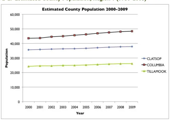
REGIONAL TRENDS
Warrenton is located in Region 1, as defined by Oregon Employment Department (OED). The population of Region 1 (Clatsop, Tillamook, and Columbia Counties) increased from 94,990 in 1995 to 101,850 in 2005. The average annual growth rate since 2000 has been about 0.7%, slower than the 1.1% rate experienced during the 1990’s but faster than the 0.2% rate during the 1980’s. Population growth slowed from 1998 through 2004 then picked up again in 2005. Clatsop County grew primarily between 1988 and 1996, when there was a strong migration into many areas in
Oregon.
Figure 2-1. Total Population, Region 1 (1980–2005)
Source: Knoder, Eric. 2005. Regional Profile Population in Region 1 (Clatsop, Columbia and Tillamook Counties).
Figure 2-2. Estimated County Population, Region 1 (1980-2005)
Source: Portland State University (PSU), Population Research Center.
The three counties in Region 1 are growing, as shown in Figures 2-1 and 2-2 above. Clatsop County's major population centers are along the coast and Columbia River.4
About one-third of the county's population resides in unincorporated areas. Within
Clatsop County, the cities experiencing the greatest population growth over the past 25 years are Warrenton and Seaside, which are on the coast and contain large tracts of developable land. Astoria has been limited in the past by a shortage of buildable land; however, recent renovations and expansion projects have helped the city to experience moderate growth.
Table 2-2. Regional Population Trends, 2000-2008
Source: Oregon Labor Market Information System (OLMIS), 2009.
AGE
It is important for parks systems to meet the recreation needs of residents of all ages. Analyzing the population by age groups can be used to adjust planning efforts for future age-related trends in recreation.
Figure 2-3. Age Distribution of Warrenton, Clatsop County, and Oregon
Source: U.S. Census Summary File 1, 2000.
In 2000, the largest percentage of Warrenton residents (29.8%) was between the ages of 25 and 44. An additional 19.1% are between the ages of 5 to 17, and 13.1% are age 65 or over. This shows a large, diversified population where a variety of park planning activities are needed to serve the entire community. Approximately 26.5% of
Warrenton is under the age of 18, indicating a large number of families in the community. Age trends show that since 1990 every age group is growing.
Figure 2-4. Warrenton Population by Age, 1990-2000
Source: U.S. Census Summary File 1, 2000.
ETHNICITY
Warrenton’s ethnic composition is changing. In 2000, 2.9% of the population identified as Latino. The percent change from 1990 (42) to 2000 (219) is 183%. This change should be taken into consideration when planning for parks in Warrenton. Based on historical growth patterns, projected Latino populations for 2010 will increase by 154% from 2000 levels. Compared with the overall percent change in Warrenton’s total population (52% from 1990 to 2000) this number is significant.
In 2000, African Americans, American Indians or Alaska Natives, and Asian or Pacific Islanders made up 0.2%, 1.3%, and 1.8% of the population, respectively. It is likely that Warrenton, and the rest of the country, will increasingly diversify over the next 20 years following national, statewide, and regional population trends. Warrenton will need to adapt its park and recreation facilities to meet the needs of residents from diverse backgrounds. This diversification has implications for staffing, maintenance, and marketing of park and recreation facilities. The City will need to understand the unique ways in which different groups use services in order to meet their needs.
HOUSING
Review of household type, housing tenure, and recent housing construction provides critical information for meeting park and recreation needs. This data assists with planning for the development of new parks and identifying potential funding sources, such as System Development Charges (SDCs). In addition, housing trends establish a picture of the type of housing being added to a community, where it is being added, and the type of homes that are being constructed.
In 2000, 26.6% of Warrenton households were family households (individuals related by birth, marriage, or adoption) while 73.4% were non-family households (individuals living alone or with non-relatives). This high percentage of non-family households highlights opportunities for the City to meet the needs of non-family households, which include older residents living alone.
In 2000, Warrenton had 1,799 housing units within its city limits as shown in Table 2-3 below.5 Roughly 59% of year round residents own their homes, while about 31% are
renters. In 2000, Warrenton also had far fewer vacant housing units than Clatsop County.
Table 2-3. Housing Tenure, Warrenton and Clatsop County, 1990 and 2000
Source: U.S. Census Summary File 1, 2000.
In 2004, there were an estimated 1,859 households in Warrenton, compared to 1,799 in 2000.6 There were an estimated 2,049 housing units in Warrenton in 2006,
indicating a vacancy rate of approximately 10.2%, compared to a vacancy rate of 9.6% and 7.3% in 2000 and 1990, respectively. Homes classified as vacant fall into two general categories: 1) those that are vacant because they are in the process of being sold or rented and are temporarily unoccupied for relatively short periods of time; and 2) those that are occupied only seasonally (second homes or vacation homes) and considered to be vacant during a majority of the year. Year 2000 Census data indicates that about 3.2% of all housing units were used for seasonal occupancy (i.e. second or vacation homes).
Most homes in Warrenton are classified as single-family detached dwellings (over 65% in 2000), with manufactured homes (in parks) accounting for almost half of the
remainder (14.3%), according to the 2000 Census.
Table 2-4. Housing Units by Structure and Occupancy, 2000
Source: U.S. Census Summary File 1, 2000.
5 Warrenton Comprehensive Plan, 2005. 6 U.S. Census Summary File 1, 2000.
ECONOMY AND INCOME
A community’s support of, desire for, and willingness to pay for park and recreation services are directly related to the strength of its economic base. Understanding Warrenton’s economic characteristics is a critical step in determining priorities for park and recreation services. This understanding will also aid the City in preparing grants and applying for alternate funding sources to help pay for park projects. Table 2-5 presents income and poverty information for Warrenton, Clatsop County, and Oregon in 2000.
Table 2-5. Income and Poverty; Warrenton, Clatsop County, and Oregon, 2000
Source: U.S. Census Summary File 3, 2000.
In 2000, Warrenton’s median household income ($33,472), median family income ($42,946) and per capita income ($16,874) were significantly lower than both Clatsop County and Oregon. Warrenton also has the highest percentage of families living below the poverty level (11.9%). However, in comparison, the percentage of
individuals living below the poverty level is greater in Clatsop County (4.4%). Poverty and income are important considerations in the parks planning process, as they influence residents’ willingness and ability to pay for higher levels of service and new park facilities.
2.4 Conclusions
This chapter describes Warrenton’s physical and social context, which forms the needs assessment for Warrenton’s parks system. The needs assessment takes into account Warrenton’s environment, demographic, and socioeconomic conditions; the current condition of the parks system; and, the park and recreation desires of the community for the Warrenton parks system. This section outlines a number of key factors to consider in planning for a parks system that meets the current and future needs of Warrenton residents.
» Warrenton’s population is expected to increase by 1.8% per year over the next 20 years, reaching 6,995 by 2030. A larger population will increase the demand for new park facilities. In particular, the City should focus efforts on creating parkland in the vicinity of new residential development in the Forest Rim area on the east side of Highway 101, and in Hammond.
» Warrenton has a large population of residents (29.8%) between the ages of 25 to 44 and a large population (19.1%) between 5 and 17. There is also a significant population (13.1%) age 65 and over. This age distribution plays a role in influencing
future park activities and development for Warrenton residents. When referencing state and regional trends, it will be important to represent all age groups in meeting recreational needs.
» Between 1990 and 2000, Latino residents made up the fastest growing ethnic group in Warrenton. This group should be considered in parks planning, as different ethnic groups may use parks differently. The LCYSA Soccer Fields are an especially important gathering place for the Latino community.
» Because of Warrenton’s high percentage of single-family dwellings (over 65%), there is an increasing demand for park facilities and open space to serve the large population of families in the area. There is also a need to serve residents who do not have access to private outdoor spaces.
» Warrenton has a high percentage of families living below the poverty level. The City itself also has the lowest median household ($33,472), median family
($42,946), and per capita income ($16,874) when compared with Clatsop County and Astoria. This data suggests that the City should explore ways to target parks and recreation services, and their benefits, toward lower-income residents. In particular, the City can look at ways to program recreational activities for this specific population.
There are a number of physical opportunities and constraints to consider in planning for the development of Warrenton’s parks facilities. Warrenton’s land area is
comprised of large areas of wetlands, which are both an opportunity and a constraint. The Warrenton Waterfront Trail does a spectacular job of providing birding and wildlife viewing opportunities through the marshes of Alder Creek and the Skipanon River. The river access provided by the flood control system constructed by the Army Corps of Engineers (ACOE) is a huge draw for residents and visitors alike. Warrenton is located in a scenic, rural area. Warrenton is surrounded by wetlands, river, beach, and ocean, with views of Washington, Saddle Mountain, and Mount St. Helens, on a clear day. These conditions, when considered in parks planning, are influential factors in the future of Warrenton’s parks, as articulated in the following chapters.
CHAPTER 3
THE PARK SYSTEM
3.1 Overview
Effective parks system planning requires identifying and assessing existing park facilities and amenities through an inventory process. The inventory process exposes system-wide strengths and weaknesses and reveals underserved areas and services.
Determining the activities that occur in each park, and the condition of facilities and amenities, helps guide recommendations and capital improvement programming efforts. The inventory process includes consideration and assignment of park classifications. Careful review of current and future park system needs by park classification type ensures a balanced parks system capable of efficient service to the community.
National Recreation and Parks Association (NRPA) classifications are used as a basis for creating a classification system specific to the needs, resources, and facilities in Warrenton. Park classification determination considers individual park benefits, functions, size, service area, and amenities. The park classifications selected for Warrenton considered park function a more important factor than park size. The classifications developed for Warrenton consist of the following categories:
» Community Park » Neighborhood Park » Mini Park
» Special Use Park » Linear Park
The parks inventory includes all parkland owned by the City as well as information about public school district and privately owned recreation facilities that are available to residents. The inventory was completed using information provided by City staff as well as field visits to park facilities.
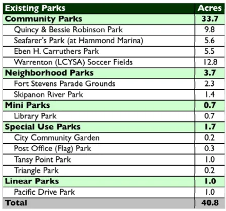
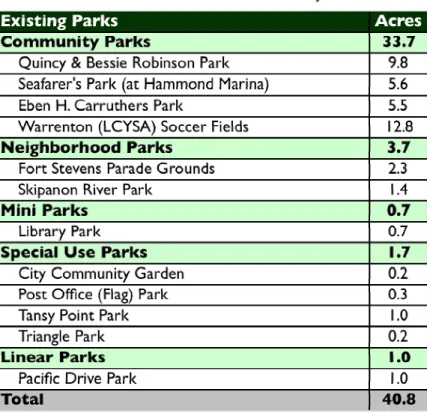
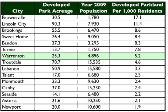
3.2 Parks System
Warrenton currently owns and maintains twelve park facilities, which comprise 40.8 acres of developed parkland. The existing parks system provides a range of park types and recreation opportunities. Different types of parks serve different functions and needs in the community. Map 3-1 illustrates the Warrenton Park System, open spaces and trails, and the regional context.
PARKS INVENTORY AND CLASSIFICATION
For the purposes of this Plan, park facilities are assessed based on amenities, size, and service area. Parks are categorized into the following park types: Community Parks, Neighborhood Parks, Mini Parks, Special Use Parks, and Linear Parks. Warrenton operates four community parks, two neighborhood parks, one mini park, four special use parks, and one linear park. Following is a summary of the park classifications and a brief description of each park facility.
Table 3-1. Warrenton Parks Inventory
Source: CPW/CMGS, 2010.
COMMUNITY PARKS
Community parks provide a variety of structured, active, passive, and informal recreation opportunities for all age groups. Community parks are generally larger in size and serve a wide base of residents. They typically include facilities that attract people from the entire community, such as sports fields, pavilions and picnic shelters, and water features, and require support facilities, such as parking and restrooms. These parks may also include natural areas, unique landscapes, and trails. Community parks may range in size from 1- to 50-acres.
» Quincy & Bessie Robinson Park is an approximately 9.8-acre community park located on SW 3rd & Alder Avenue. The park is named for the park’s benefactors who created a private trust to fund park projects in the City of Warrenton. Centrally located and highly used, the park offers a range of
structured activities, from basketball to baseball, as well as community use facilities such as community gardens and the community center. To the west and south lies
undeveloped forest area, some of which is City-owned open space. The park has access to the Warrenton Grade School Trail.
» Seafarers Park is an approximately 5.6-acre community park located at the Hammond Marina. The park is a visitor’s destination dedicated to the men of the Mermaid and Triumph who lost their lives in a devastating 1961 storm. The land is owned by the Army Corps of Engineers and leased by the City. The City owns and operates all marina improvements. Currently only partially developed, the park is well used, especially in the summertime when there are weddings at the gazebo and families picnicking on the beach. Residents and visitors alike enjoy the natural beautiful setting and Waterfront Trail access.
» Eben H. Carruthers Park is an approximately 5.5-acre community park located off of Warrenton Drive (Fort Stevens Highway 104). The park is bordered by a lumber mill to the east, the Columbia River to the north, and wooded
undeveloped area to the west that is designated for residential development. A multi-use path has been newly paved and widened leading to the historical Lewis & Clark informational viewpoint off of the Columbia River. The new dog park receives heavy used by the community.
» Warrenton (LCYSA) Soccer Fields are an approximately 12.8-acre community park. There are three soccer fields: two on one side of Ridge Road, and one on the other. On the west side of the road, the north end of Field 2 and all of Field 3 are on County land that is leased by LCYSA. In 2008, LCYSA’s lease with Clatsop County was extended to 2023. The park is operated and maintained by the Lower Columbia Youth Soccer Association (LCYSA). As a reclaimed former landfill site, the City takes flammable gas readings every month and a geologist takes readings from wells to ensure user safety. Volunteers take very good care of the property, as exemplified by the service of Harold Henry Snow (1908-2008) for whom a memorial is dedicated for Field 2. The park has access to the Shag Lake Trail and includes unimproved parking areas on either side of Ridge Road. The park is generally not accessible by alternative modes and is dependent upon vehicular access. There are no sidewalks on Ridge Road, leading to the park, and it is outside comfortable walking distance from most homes and schools.
NEIGHBORHOOD PARKS
Neighborhood parks are located within walking and bicycling distance of most users. Neighborhood parks provide access to basic recreation activities for nearby residents of all ages, function as critical open space, and are often defining elements of a
neighborhood. These parks are generally 1- to 5-acres in size and serve residents within ¼ to ½-mile radius. Neighborhood parks typically include facilities such as playgrounds, basketball courts, tennis courts, lawn areas, picnic tables, and benches. » Fort Stevens Parade Grounds is an approximately 2.3-acre neighborhood
park that holds historical significance as military parade grounds from the Civil War until WWII. The grounds are a large, city-owned open grass space with a few large oak trees, a shelter, and play equipment. The park is surrounded by colonial-style homes and a bed and breakfast.
» Skipanon River Park is an approximately 1.4-acre neighborhood park located near downtown along the Skipanon River. A linear park with a paved trail and grassy dike links a paved parking lot at 3rd Street to the 2nd Street Kayak Dock.
The paved parking lot area is the trailhead of the Warrenton Waterfront Trail, linking to miles of connecting trails in the city system. The kayak dock has space for a couple of vehicles to park in an unpaved area off of an unimproved access road on 2nd Street. The parking area is connected to the trail and dock by a
meandering pedestrian ramp. The park gets heavy use during the months of May through September and is attractive to visitors.
MINI PARKS
Mini parks are typically located on small parcels and provide passive or limited active recreation opportunities. Mini parks provide basic neighborhood recreation amenities, such as playgrounds, sport courts, benches, and lawn areas. These parks are generally smaller than 1-acre and serve residents within a ¼-mile radius.
» Library Park is an approximately 0.7-acre mini park located at 681 Pacific Drive, adjacent to the Hammond Library. The park consists of a play structure that is in good condition, storage shed, bench, and two planter pots. The park contains trees, flowers, and shrubs along the perimeter. The park has special use in the regard that it is specifically by families during visits to the library. There are newly paved parking spaces in front of the library. Pacific Drive Park is across the street, separating Library Park from 6th Avenue.
SPECIAL USE PARKS
Special use parks are recreation sites or parkland occupied by a specialized facility designed to serve a specific function. Facilities typically included in this classification are sports field complexes, community centers, community gardens, skate parks, aquatic centers, and amphitheaters.
» City Community Garden is an approximately 0.1-acre special use park. It is privately owned by neighboring residential property owners and is leased to the City of Warrenton. The park is in the initial stages of development and includes fencing and raised garden beds.
» Post Office (Flag) Park is an approximately 0.3-acre special use park owned by the City of Warrenton and maintained by the Veterans of Foreign Wars (VFW). Located in the heart of downtown at 99 S. Main Avenue, this small park is intended for viewing and honoring the VFW. The park contains a small area with picnic tables is owned by the City and used primarily by patrons of the adjacent restaurant.
» Tansy Point is an approximately 1-acre special use park. The park site was a native village for Clatsop tribes before the days of Lewis & Clark and is known for the historical Anson-Dart Treaties of 1851. Today, the park contains an access road leading to a roundabout where visitors can drive by and glimpse a view of the Columbia River and the shores of Washington. The landscape consists of grass, wetlands, and sparse trees. Visitors can access the Waterfront Trail through the
trailhead at 13th Street. The park experiences the most activity from May through
September and the City responds by installing picnic tables for those months. » Triangle Park is an approximately 0.2-acre special use park that is a triangle
shaped open lawn wayside containing a statue. The statue was donated to the City of Warrenton in 2003 by Martin Nygaard of Warrenton Fiber and Nygaard
Logging. The statue was a gift to Mr. Nygaard by David Lum, his neighbor in Warrenton, who bought it from an artisan in Washington’s San Juan area. Carved from wood, stained, and painted, the statue features a tree, eagle, bear, fish, and lumberjack. It represents the timber industry’s respect for northwest wildlife.
LINEAR PARKS
Linear Parks are developed landscape areas that follow linear corridors such as streams, power lines, and other linear features. Linear Parks provide a transportation corridor linking neighborhoods to parks, schools, and shopping areas. They provide a variety of passive recreational opportunities all free or relatively free from automobile interference.
»
Pacific Drive Park is an approximately 1-acre linear park. The park is a long, narrow, grass promenade separating Pacific Drive and 6th Street. The parkcontains a line of orchard trees along its length. Near either end of the park is an artful tile and concrete planter. In the center is a bell as a historical art piece. The park has no curbs or sidewalks. The park is within ODOT right-of-way but is maintained by the City.
TRAILS
The City of Warrenton adopted a Trails Master Plan in 2008, which describes the City’s existing and proposed trail system in detail. The Trails Master Plan identifies five trails outside of the City that Warrenton’s proposed trails will connect with. The plan also identifies ten existing trails and seven proposed trails within Warrenton, some of which have been constructed or are in planning stages. The Trails Master Plan is incorporated by reference herein.
OTHER CITY PARK AND RECREATION FACILITIES
In addition to identifying city-owned and city-maintained properties, the inventory provides information on local school facilities, publicly and privately owned recreation areas, and parks that may be outside the community but are commonly used by Warrenton residents. Acknowledgment of these facilities, and the services they provide to the community, is important to consider in evaluating decisions addressing future facility locations and community needs.
Hammond Marina
The Hammond Marina is connected to Seafarer’s Park and is operated by the City of Warrenton. It is owned by the Army Corps of Engineers and started leasing to the City of Hammond in 1967. The City of Warrenton took over the lease when
Hammond and Warrenton merged in 1991.7 The marina is located just south of the
mouth of the Columbia River and Pacific Ocean. Warrenton Mooring Basin
The Warrenton Mooring Basin is located at 550 NE Harbor Drive and is City-owned and operated. Open year-round, it has 370 slips of which 20 are reserved for
transient boats. The facility also provides restrooms, showers, a pump-out, trash pick-up, dock carts, and docking assistance.
Warrenton Community Library
The Warrenton Community Library is located at 225 S. Main Avenue. Library Park is located directly to the west of the Library. The Library is the former site of the Hammond City Hall before Hammond was incorporated and included within Warrenton’s city limits. The library holds over 20,000 items including 400 audio books and 300 videos and DVDs. The Friends of the Library foundation puts on a variety of programming for the community.8
Warrenton Community Center
The Warrenton Community Center is located at 170 SW 3rd Street. The center holds
gatherings and functions from wedding receptions to seminars for up to 135 people. It provides table seating for around 72 people and a full kitchen. It has two small decks off of the back, which are adjacent to Quincy & Bessie Robinson Community Park near the community garden.
WARRENTON-HAMMOND SCHOOL DISTRICT 30
The Warrenton-Hammond School District is comprised of two schools located on separate sites: a high school and grade school. Together they serve 915 students within the district.9
Warrenton Grade School
There are 556 students grades K-8 attending Warrenton Grade School located at 820 SW Cedar Street. Facilities include a football field, quarter mile track with high jump and long jump pits, a shot-put sector, a baseball field, three covered basketball half courts, wall-ball and four square courts, a play structure, a climbing wall, a tire swing, fourteen swings, two climbing structures, and a triple ball hoop. Indoor facilities include a full size basketball gym with two sets of bleachers and a multipurpose cafeteria.
Warrenton High School
There are 285 students, grades 9-12 attending Warrenton High School located at 1700 SE Main Street. Facilities include a football field, baseball field, and indoor gymnasium.
7 NOAA Northwest Fisheries Science Center 8 City of Warrenton
PRIVATE SCHOOLS IN WARRENTON
There are four private school facilities within the City of Warrenton serving 187 students.10
Coryell’s Crossing Incorporated School
This non-sectarian private school serves 30 children from pre-kindergarten to kindergarten. It is an early-childhood program and daycare center.
North Coast Christian School
Located at 796 Pacific Drive, the North Coast Christian School is a ministry of the Philadelphia Church of Hammond and a Pentecostal private school teaching 100 students grades K-8.
Warrenton High South Jetty Campus School
This high school teaches 74 alternative students grades 8-12 through the Oregon Youth Authority. It is located at 1250 SE 19th Street.
PRIVATE PARKS AND RECREATION FACILITIES
Lighthouse Park & Interpretive Center
Lighthouse Park & Interpretive Center is located at the intersection of Main Avenue and Harbor Street. The center serves as a memorial to lives lost in the fishing industry and houses Warrenton and Hammond historical society artifacts. Facilities include a model lighthouse, bench, memorials, displays of fishing relics as public art, and picnic tables. It is staffed and open between Memorial Day and September 15th with
admission to the lighthouse and mini-museum by donation.11
Skipanon Landing
This privately owned marina is located at 200 NE Skipanon Drive, is open year-round, and has 92 slips of which just two are reserved for transient boats, which require reservations. Other facilities include restrooms, showers, pump out, book exchange, and mail & package holding.
Kamper’s West RV Park
The Kamper’s West RV Park is located at 1140 NW Warrenton Drive #324 and comes with complete RV club facilities that are open year round. The RV Park has 160 RV sites, 30 AMP hookups, a 100 person club room, a 35 person club room, laundromat, convenience store, LP gas, dump station, and fish cleaning pavilion.12
Warrenton KOA Campground
Warrenton’s KOA Campground is located at 1100 NW Ridge Road and includes an indoor pool & spa, family recreation room, game room, group facilities, playgrounds,
10 Schooltree.org
11 Warrenton Business Association 12 kamperswest.com