13
Water Resources and Flood Risk
13.1
Introduction
13.1.1 This chapter provides an assessment of the potential construction and
operational impacts on water resources and flood risk associated with the Bank Station Capacity Upgrade (BSCU). Construction works will comprise deep level tunnelling works and excavations for the escalator barrels and box, passenger lifts, Arthur Street Shaft, utilities access shafts and general utilities works. It is assumed that compensation grout shafts to mitigate settlement impacts will not be required, but as a reasonable worse case, the water
resources and flood risk assessment has assumed their introduction during the construction phase.
13.1.2 This chapter also considers the demolition of existing buildings at the Whole Block Site, as this is required to allow construction of the BSCU.
13.1.3 In the context of this chapter, the term ‘water resources and flood risk’ covers the assessment of impacts on:
surface water and groundwater resources (i.e. the flows and levels within the River Thames and the shallow and deep aquifers);
surface water and groundwater quality (i.e. the water quality in the River Thames and the shallow and deep aquifers); and
flood risk from natural and artificial sources.
13.1.4 The September 2013 EIA Scoping Report (Appendix A1.1) for the BSCU proposed scoping out the deep aquifer and a Flood Risk Assessment (FRA) from the EIA. However, after further consideration of baseline conditions and potential impacts, these are now included within the scope.
13.2
Legislative and Policy Context
Legislation and National PolicyEU Water Framework Directive (2000/60/EC)
13.2.1 The Water Framework Directive (WFD) provides a framework in the form of a river basin planning system on a six year cycle, with the aim of protecting water dependent ecosystems, promoting sustainable water use, reducing releases of hazardous and non-hazardous substances, and contributing to mitigating effects of floods and droughts.
13.2.2 Any activities or developments that could cause detriment to a nearby water resource, or prevent the future ability of a water resource to reach its potential
status, must be mitigated so as to reduce the potential for deterioration and allow the objectives of the Directive to be realised.
EU Groundwater Directive, Groundwater Daughter Directive and Environmental Permitting Regulations (2010)
13.2.3 The Groundwater Directive targets the prevention of groundwater pollution by controls on the release of substances listed within it. The directive, repealed in December 2013, has been superseded by the WFD and the Groundwater
Daughter Directive (GWDD). The latter has been transposed in England and
Wales via the Environmental Permitting Regulations (EPR) 2010 and amendments.
National Planning Policy Framework (Department for Communities and Local Government, 2012)
13.2.4 There are a number of policies relevant to this water resources and flood risk chapter within the National Planning Policy Framework (NPPF), including those in Section 10 (paragraphs 99, 100, 101 and 103) and in Section 11 (paragraph 109).
13.2.5 The specific methodology for defining and assessing flood risk is dictated by the requirements of the NPPF and its Technical Guidance and is set out in the FRA (see Appendix A13.1).
Planning Practice Guidance (Department of Communities and Local Government, 2014)
13.2.6 The national Planning Practice Guidance(PPG) was launched on the 6th March 2014 and provides a web-based resource in support of the NPPF. 13.2.7 The PPG provides guidance and explanatory advice regarding Water Supply,
Wastewater and Water Quality and Flood Risk and Coastal Change in support
of NPPF policies and other published guidance. The PPG provides advice to local planning authorities regarding plan making, decision taking, consultation with statutory and national amenity groups in respect of planning and consent applications.
Regional Policy
The London Plan (Greater London Authority, 2011)
13.2.8 Key policies from The London Plan include the following:
Policy 5.12 (as amended by The London Plan Revised Early Minor
Alterations), Flood Risk management: Comply with the flood risk assessment and management requirements set out in the NPPF and associated technical guidance on flood risk over the lifetime of the
development. Measures proposed in Thames Estuary 2100 and Catchment Flood Management Plans should be considered.
Policy 5.13, Sustainable drainage: Development should utilise SuDS unless
there are practical reasons for not doing so and should aim to achieve greenfield run-off rates.
Policy 5.14, Water quality and wastewater infrastructure: Ensure that
adequate wastewater infrastructure capacity is available in tandem with development.
Local Policy
Core Strategy (City of London Corporation, 2011)
13.2.9 Key policies comprise:
Policy CS15: Sustainable Development and Climate Change: To enable
businesses and residents to make sustainable choices creating a more sustainable City of London:
Requiring development to positively address ... water quality and flood
risk particularly in areas at risk of sewer flooding
Incorporating climate change adaptation measures into development
and infrastructure, including utility infrastructure.
Policy CS18: Flood Risk: To ensure that the City remains at low risk from all
types of flooding, by:
Minimising river flooding risk;
Submitting flood risk assessments for major development proposals;
and
Reducing the risks of flooding from surface water, ensuring that
development proposals minimise water use and reduce demands on the combined surface water and sewerage network by applying the London Plan drainage hierarchy.
13.3
Assessment Methodology
Source-Pathway-Receptor Model
13.3.1 The assessment model identifies the potential sources of impact as well as the receptors (water resources) that could potentially be affected. In addition, there needs to be a clear mechanism or ‘pathway’ via which the source can have an effect on the receptor.
13.3.2 The identification of potential water resource receptors has been undertaken through a study of baseline data. The sources and potential pathways for
impact are identified through a review of the details of the BSCU, including the size and nature of the development, potential construction methodologies and timescales. This is undertaken in the context of local conditions relevant to water resources near the BSCU, such as topography, geology and climatic conditions.
Determining Effects - Water Resources
13.3.3 Once receptor sensitivities and potential impacts are identified, as described above, it is necessary to determine the effect on the receptor, so that potential mitigation measures can be identified to counteract any significant adverse effects.
13.3.4 An assessment of the significance of each effect has been undertaken based on the methodology provided in the Web-based Transport Analysis Guidance; specifically the Water Environment Sub-Objective WebTAG Unit 3.3.11.
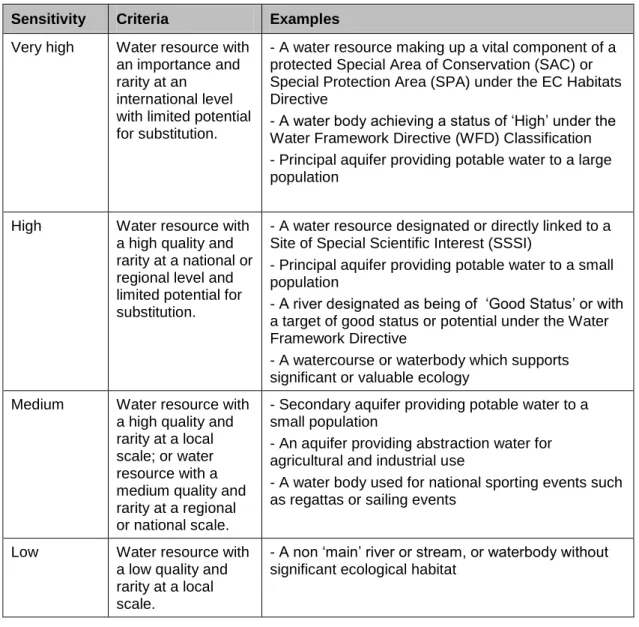
Receptor Sensitivity
13.3.5 The sensitivity of each water resource (the receptor) is based on its considered value e.g. as a water dependent ecological habitat, a source of drinking water or as a recreational resource (see Table 13.1).
Magnitude of Impact
13.3.6 The magnitude of a potential impact is established based on the likely degree of impact relative to the character and extent of the BSCU (see Table 13.2). The derivation of magnitude is carried out independently of the sensitivity of the water resource.
Assessment of Effects
13.3.7 Once the magnitude of an impact is derived, the potential effect can be categorised by combining the assessments of both the sensitivity of the
receptor and the magnitude of the impact in a simple matrix (see Table 13.3).
13.3.8 Effects which are assessed to be major or moderate are generally considered to be significant (and in need of mitigation); those that are minor and negligible are generally not considered to be significant, however determination of
whether an effect is considered to be significant is also based on professional judgement, taking account of whether effects are considered to be positive or negative, permanent or temporary, direct or indirect, and the duration/frequency of the effect.
Table 13.1: Sensitivity of Water Resource Receptors
Sensitivity Criteria Examples Very high Water resource with
an importance and rarity at an
international level with limited potential for substitution.
- A water resource making up a vital component of a protected Special Area of Conservation (SAC) or Special Protection Area (SPA) under the EC Habitats Directive
- A water body achieving a status of ‘High’ under the Water Framework Directive (WFD) Classification - Principal aquifer providing potable water to a large population
High Water resource with a high quality and rarity at a national or regional level and limited potential for substitution.
- A water resource designated or directly linked to a Site of Special Scientific Interest (SSSI)
- Principal aquifer providing potable water to a small population
- A river designated as being of ‘Good Status’ or with a target of good status or potential under the Water Framework Directive
- A watercourse or waterbody which supports significant or valuable ecology
Medium Water resource with a high quality and rarity at a local scale; or water resource with a medium quality and rarity at a regional or national scale.
- Secondary aquifer providing potable water to a small population
- An aquifer providing abstraction water for agricultural and industrial use
- A water body used for national sporting events such as regattas or sailing events
Low Water resource with a low quality and rarity at a local scale.
- A non ‘main’ river or stream, or waterbody without significant ecological habitat
Table 13.2: Magnitude of Water Resource Impact
Magnitude
of Impact Criteria Examples High Impact results in a
shift in a water body’s potential attributes.
- Change in WFD classification of a waterbody - Loss of flood storage/increased flood risk - Pollution of potable source of abstraction Medium Results in impact on
integrity of attribute or loss of part of attribute.
- Contribution / reduction of a significant proportion of the effluent in a receiving river, but insufficient to change its WFD classification
- Reduction / increase in the economic value of the feature
Low Results in minor impact on water body’s attribute.
- Measurable changes in attribute, but of limited size and / or proportion
Very Low Results in an impact on attribute but of insignificant magnitude to affect the use / integrity.
- Physical impact to a water resource, but no
significant reduction / increase in quality, productivity or biodiversity
- No significant impact on the economic value of the feature
- No increase in flood risk Table 13.3: Classification of Effects on Water Resources
Sensitivity of Receptor
Magnitude of Impact
High Medium Low Very Low
Very High Major Major Moderate Moderate
High Major Moderate Moderate Minor
Medium Moderate Moderate Minor Negligible Low Moderate Minor Negligible Negligible
Flood Risk Assessment Methodology
13.3.9 Following the Technical Guidance and requirements of the NPPF, the FRA (See Appendix A13.1) assesses the potential flood risk associated with the existing site, identifies the potential impacts the BSCU may have on flood risk and outlines the appropriate mitigation measures.
13.3.10 FRAs identify potential flood risks both to and as a result of the BSCU. Using the FRA methodology, sites at risk are not graded by a ‘sensitivity’ as it is assumed that all areas affected by flooding are equally important. NPPF
simply requires that proposed development should not increase flood risk elsewhere (i.e. no adverse effect) and should reduce flood risk where possible. In the absence of an assigned ‘value’ for receptors, the significance of effect
will be based on a qualitative assessment of the likely magnitude of the flood risk effects.
Temporal Scope: Baseline and Assessment Years
13.3.11 The current baseline year is taken as 2013 since this is when the majority of baseline work has been undertaken. The assessment years are construction (2016-2021) and beginning of operation/use (2021).
Spatial Scope
13.3.12 The description of the baseline focuses on the area within 1km of the BSCU, since it is deemed unlikely that impacts on water resources and flood risk receptors would extend beyond this distance given the nature of the BSCU. It also considers any key receptors outside of this area that may be hydraulically connected to water resources inside the area e.g. if a groundwater abstraction borehole is located 2km away but has a source protection zone that extends to within 1km of the BSCU.
13.4
Baseline Conditions
Information Sources
13.4.1 A key source of site specific information is the September 2013 Envirocheck report, commissioned for this BSCU baseline assessment (Appendix A14.10).
13.4.2 A detailed review of geology and groundwater conditions has also been undertaken by referring to historic and current ground investigation data. This has been used to inform an understanding of regional groundwater flow
direction and the development of a basic numerical groundwater model for the shallow aquifer.
13.4.3 A summary of the baseline conditions is described below. Topography
13.4.4 The Whole Block Site has ground elevations of between 14 and 15mAOD. Further to the south at the proposed Arthur Street Work Site, ground elevations are lower at around 12mAOD.
13.4.5 The BSCU includes a new southbound platform and running tunnel for the Northern Line. Ground elevations along the proposed route are generally between 10 and 15mAOD, although at its southern limit where it re-joins the existing Northern Line, ground elevations are around 5mAOD.
Hydrology and Surface Water Drainage
13.4.6 The BSCU is located directly north of the tidal River Thames within the Thames River Basin District. Based on Port of London Authority tide information, at the
nearby Blackfriars Bridge, the spring low tides are around -3mAOD and spring high tides are around 4mAOD. The River Thames is brackish in London owing to mixing with seawater.
13.4.7 The River Thames in the vicinity of the BSCU is included within the ‘THAMES MIDDLE’ (GB530603911402) water body under the WFD. It is classified as a heavily modified water body, with a current ecological quality status of
‘Moderate Potential’ and a target ecological quality status of ‘Good Potential’. The current chemical quality status is ‘Fail’ as a result of priority hazardous substances and a number of specific determinands.
13.4.8 The Water Resources Baseline Report (Mott MacDonald, August 2011, Appendix A13.2) indicates that the Whole Block Site is located approximately 100m east of the culverted River Walbrook which is identified as one of the ‘Lost Rivers of London’ (a term used for historic rivers in London which have been incorporated into the sewer network).
13.4.9 In the central London setting of the BSCU, the area is largely hard standing and surface water run-off drains to a series of combined sewers. Thames Water Utilities Limited, known as Thames Water, sewer asset plans (ref:
ALS/227340/SEWER) confirm that a large trunk sewer flows from north to south beneath Walbrook (approximately 100m west of the Whole Block Site). This combined sewer has an overflow outfall into the River Thames near Walbrook Wharf.
13.4.10 Thames Water sewer asset plans show combined sewers in the vicinity of the BSCU. Those most relevant comprise:
one trunk sewer underneath King William Street (of unknown dimensions);
one 3.5m diameter trunk sewer beneath Cannon Street;
two low level sewers running from north to south under Abchurch Lane (west of the site) and Nicholas Lane (east of the site); and
two combined sewers running parallel with the trunk sewer beneath Cannon Street.
13.4.11 These combined sewers are believed to be at depths of between 4.5m and 12.2m and carry both surface water run-off and foul water from local premises.
13.4.12 The Thames Water sewer asset plans indicate that a single 1,372 x 813mm combined sewer runs from east to south-west under the Arthur Street Work Site, with an additional connection coming in from a combined sewer under Martin Lane. The plans indicate that this sewer is located approximately 3 to 4.5m below ground level.
13.4.13 The local Thames Water combined sewer network is a potential pathway for the transport of untreated surface and wastewater to the River Thames via combined sewer overflows after a substantial rainfall event.
Discharge Consents and Surface Water Abstractions
13.4.14 The Envirocheck report indicates a number of current and revoked discharge consents within 1km of the Whole Block Site and Arthur Street Shaft (see Appendix A14.10). There are four existing consents within 500m of the BSCU and these are associated with sewerage network discharges into the River Thames by Thames Water; the closest is at London Bridge.
13.4.15 There is one current licensed surface water abstraction from the River Thames within 1km of the Whole Block Site and Arthur Street Shaft. The licence
number is 28/39/39/0153 and it is operated by City of London Corporation at Walbrook Wharf for industrial processing with a maximum abstraction rate of 144m3/day.
Geology and Hydrogeology
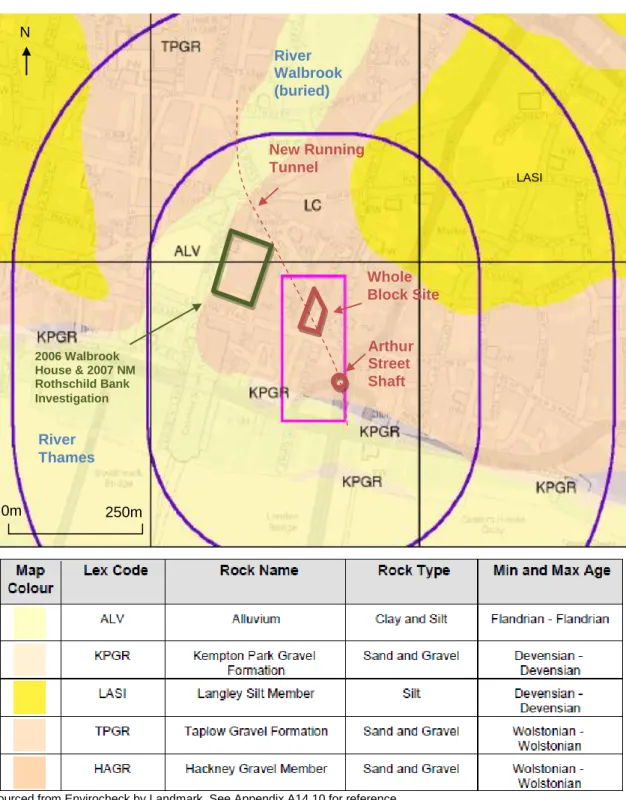
13.4.16 The 1:10,000 scale British Geological Survey (BGS) geological map for the study area is included in the Envirocheck report (see Appendix A14.10) and an extract is provided in Figure 13.1.
Superficial Deposits and Aquifers
13.4.17 Towards the south of the BSCU there exist Alluvium deposits (‘ALV’ on Figure 13.1) comprising clay and silt associated with the River Thames. A ribbon of Alluvium associated with the buried River Walbrook also extends northwards from the River Thames near Cannon Street Station, crossed by the proposed new running tunnel route.
13.4.18 The superficial geology in the vicinity of the BSCU largely comprises the sands and gravels of the Taplow Gravel Formation (‘TPGR’ on Figure 13.1).
13.4.19 The base of the Taplow Gravel Formation in and around the Whole Block Site and Arthur Street Shaft can be expected at an elevation of between 4mAOD and 7mAOD. Beneath the Whole Block Site it is expected to be up to around 3m to 4m thick. However, in the study area, basements and foundations have removed part or all of the thickness of these superficial deposits.
13.4.20 For the purpose of this assessment the Alluvium and Taplow Gravel Formations are referred to as the ‘shallow aquifer’.
13.4.21 Groundwater levels in the shallow aquifer are expected to vary between 4mAOD and 9.5mAOD in the vicinity of the BSCU, at depths of between 4.5m below ground level (following a prolonged wet period/other event such as a burst water main) and 10.5m below ground level (when the shallow aquifer is
largely unsaturated). Preliminary groundwater monitoring results from BSCU geotechnical boreholes are within this range and suggest that the shallow aquifer is largely unsaturated in the vicinity of the Whole Block Site.
13.4.22 Groundwater flow in the shallow aquifer is expected to be to the south or south-west in the vicinity of the BSCU. However, it is unlikely that permanently
saturated conditions and a water table exist locally within the shallow aquifer. This is owing to the elevated ground level and the dipping gradient on the base of the aquifer, which encourages groundwater to flow away from the local area. 13.4.23 The neap high tides and spring high tides in the River Thames are around
3mAOD and 4mAOD, respectively. This is below the base of the aquifer and therefore the tidal influence on groundwater levels in the shallow aquifer will be negligible, except perhaps along the line of the buried River Walbrook and to the south of the Arthur Street Shaft where Alluvium deposits are mapped (Figure 13.1).
Bedrock and Aquifers
13.4.24 The bedrock geology immediately beneath the superficial deposits (at around 4mAOD to 7mAOD) is the London Clay Formation. The base of the London Clay Formation is expected to lie at between -35mAOD and -40mAOD. This overlies the Lambeth Group, Thanet Formation and Chalk.
13.4.25 The Thanet Formation and Chalk form a principal aquifer in the study area. For the purpose of this assessment, the Thanet Formation and Chalk are referred to as the deep aquifer.
13.4.26 The shallow and deep aquifers are hydraulically separated by the low
permeability London Clay Formation and Lambeth Group. These are referred to as Unproductive Strata by the Environment Agency but can contain sandy material leading to localised ingress of water and seepage associated with claystone layers.
13.4.27 Groundwater levels in the deep aquifer have been relatively stable since the year 2000 at around -35mAOD (+/- 5m) and groundwater flow is to the west.
13.4.28 There are no WFD groundwater bodies mapped on the Environment Agency website in the vicinity of the BSCU.
Figure 13.1: Geological Map – Superficial Deposits
Groundwater Users and Water Quality Shallow Aquifer
13.4.29 The urban character of central London combined with the vulnerability of the shallow aquifer to pollution is such that the aquifer is generally unsuitable for potable water supply abstractions. It is also unlikely to be suitable for
non-Sourced from Envirocheck by Landmark. See Appendix A14.10 for reference.
0m 250m N New Running Tunnel LASI Whole Block Site Arthur Street Shaft River Walbrook (buried) River Thames 2006 Walbrook House & 2007 NM Rothschild Bank Investigation N 0m 250m
potable water supply use in the area of the BSCU owing to the thin saturated thickness of aquifer i.e. it will not provide reliable quantities of water. There are no BGS water well records for the shallow aquifer within the vicinity of the BSCU.
Deep Aquifer
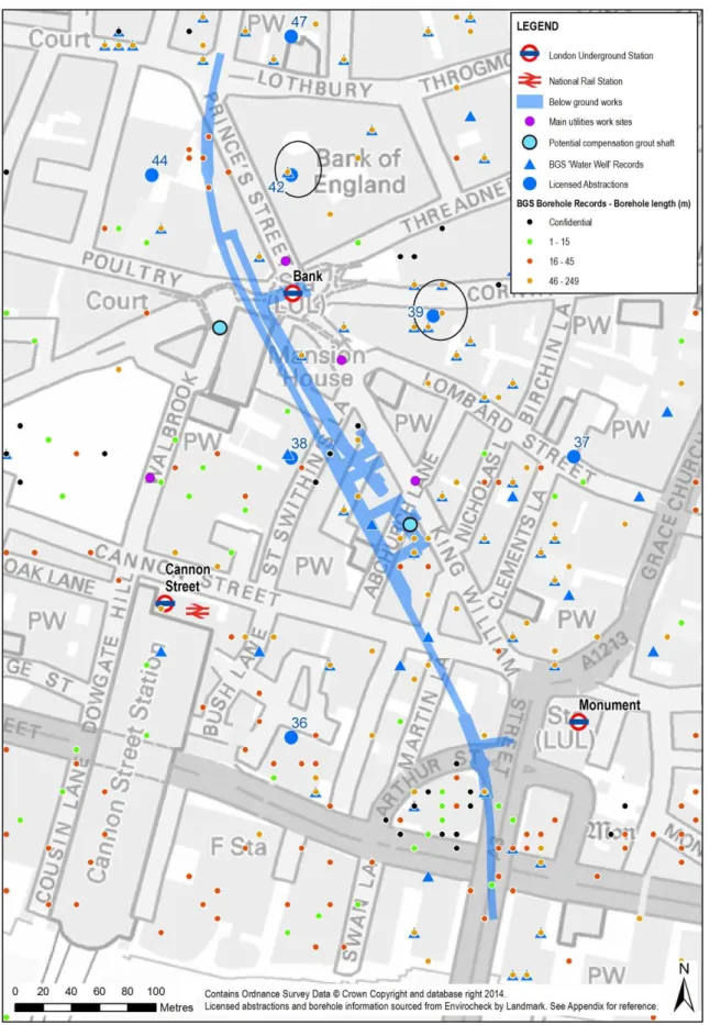
13.4.30 The Environment Agency defines Source Protection Zones (SPZs) to protect groundwater sources used for public drinking water supply. There are no SPZs within 1km of the BSCU. The Envirocheck report (see Appendix A14.10)
includes records for 33 current and historic licensed abstractions and approximately 700 boreholes within 1km of the Whole Block Site.
13.4.31 LUL undertook consultation with the Environment Agency in March 2012 to update the status of licensed wells, reported on within the LUL Report,
Abstraction and Historic Wells (see Appendix A14.9). This indicated there were
only two active abstractions (28/39/39/0166 and 28/39/39/0024), which are 39 and 42 respectively within the Envirocheck report. Their approximate locations are shown on Figure 13.2.
Environmental Designations
13.4.32 There are no water dependent environmental sites (e.g. SSSI or Natura 2000 sites) within 1 km of the BSCU.
Existing Flood Risk
13.4.33 The FRA considers the existing risk of flooding from fluvial, tidal, surface water, overland flow, groundwater and artificial sources (see Appendix A13.1). With regard to the existing conditions, the FRA considers that:
the BSCU Work Sites are located within the Environment Agency Flood Zone 1 and are therefore considered to be at low risk of fluvial and tidal flooding (i.e. less than one flooding event every 1,000 years);
the sites are not considered to be at risk from a breach in the River Thames flood defences;
there is a low risk that LUL and Docklands Light Railway (DLR) portals elsewhere on the network could act as potential pathways for the conveyance of fluvial and tidal floodwater through the LUL network;
both work sites are considered to be at low risk of flooding from surface water and sewers;
the risk of groundwater flooding at the surface level is considered to be low, although there is potential for elevated groundwater levels (within 2m of ground surface) in the Walbrook valley as identified in the Surface Water
Management Plan and subsequent Strategic Flood Risk Assessment for the
City of London;
structures located within the shallow aquifer will be waterproofed, thereby mitigating the risk from this source. Structures located within the London Clay Formation are considered to be at low risk of flooding from groundwater ingress due to the limited permeability of the strata;
a burst water main poses a risk to surface-level and below ground assets. Outputs from the forthcoming London Underground Comprehensive Review of Flood Risk (LUCRFR) assessment will be utilised to inform the detailed design of any mitigation measures if and where it is considered to be necessary; and
there may be a low risk of water ingress from the disused City and South London running tunnels and from the existing disused LUL King William Station through which the Arthur Street Shaft will be constructed.
Receptor Sensitivity
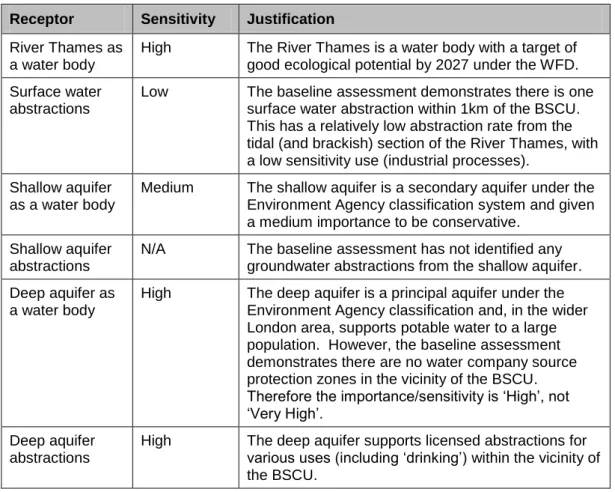
13.4.34 The sensitivity of each receptor is based on its considered value. The assessed importance/sensitivity of identified receptors is given in Table 13.4.
13.4.35 The River Thames and supported surface water abstractions are assessed within this chapter because the BSCU will involve discharges to the River Thames via the Thames Water drainage network.
13.4.36 The shallow aquifer is assessed because the BSCU requires excavation into the aquifer, which introduces a direct pathway for pollution sources such as spillages and the potential to influence groundwater flows and levels.
13.4.37 The deep aquifer is assessed because the BSCU may intercept/damage
existing boreholes/wells, introducing a direct pathway for pollution sources such as spillages.
Table 13.4: Water Resource Receptors
Receptor Sensitivity Justification River Thames as
a water body
High The River Thames is a water body with a target of good ecological potential by 2027 under the WFD. Surface water
abstractions
Low The baseline assessment demonstrates there is one surface water abstraction within 1km of the BSCU. This has a relatively low abstraction rate from the tidal (and brackish) section of the River Thames, with a low sensitivity use (industrial processes).
Shallow aquifer as a water body
Medium The shallow aquifer is a secondary aquifer under the Environment Agency classification system and given a medium importance to be conservative.
Shallow aquifer abstractions
N/A The baseline assessment has not identified any groundwater abstractions from the shallow aquifer. Deep aquifer as
a water body
High The deep aquifer is a principal aquifer under the Environment Agency classification and, in the wider London area, supports potable water to a large population. However, the baseline assessment demonstrates there are no water company source protection zones in the vicinity of the BSCU. Therefore the importance/sensitivity is ‘High’, not ‘Very High’.
Deep aquifer abstractions
High The deep aquifer supports licensed abstractions for various uses (including ‘drinking’) within the vicinity of the BSCU.
13.5
Incorporated Mitigation
13.5.1 Where possible, potential environmental impacts will be prevented through the application of the Code of Construction Practice (CoCP) and design of the BSCU. These aspects are discussed below.
Whole Block Site
13.5.2 A waterproofing strategy has been developed for the escalator box and piled passenger lift shaft at the Whole Block Site comprising:
secant pile wall through the shallow aquifer, with sufficient embedment into the London Clay Formation (1 to 2m);
contiguous pile wall through the clay layer extending to a depth below the base slab;
structural reinforced concrete lining wall tied back to the piles at regular intervals;
temporary bunding to prevent the ingress of water from the escalator box and passenger lift shaft during construction, following construction of the link tunnels and adits;
a drained cavity wall in public and staff areas; and
residual water ingress collected via channels and pipes from drained cavities in public areas, and slab up stand kerbs in plant rooms, and removed via a pumped sump.
13.5.3 The water proofing is required because excessive dewatering of the shallow aquifer and the corresponding change in pore water pressure could lead to consolidation settlement and building damage. In addition to mitigating impacts on the shallow aquifer and existing buildings, it will also mitigate the low risk of groundwater flooding to the BSCU and existing tunnels and platforms.
Arthur Street Shaft
13.5.4 The Arthur Street Shaft will be aligned with the centre of the new running tunnel and will connect into the disused King William Street Station. The Arthur Street Shaft will pass through the shallow aquifer and into the London Clay Formation.
13.5.5 Construction for the upper section of the Arthur Street Shaft will be a 9m deep rectangular sheetpile shaft followed by a 32m deep oval section spray concrete lining (SCL) shaft. The sheetpiles provide a low permeability barrier between the Arthur Street Shaft and the shallow aquifer and also support unstable superficial deposits during construction. As with the Whole Block Site shaft, excessive dewatering will be prevented to maintain pore water pressure and so minimise settlement and building damage.
Flood Risk Prevention
13.5.6 No mitigation is considered necessary to protect the site from fluvial and tidal flooding as it is located within the Environment Agency’s Flood Zone 1 (the zone of lowest flood risk).
13.5.7 There is a low residual risk of flooding from pluvial and sewer sources to the Station Entrance. Residual risk will be managed through the provision of passive flood resilience and resistance measures in accordance with clause
3.1.6.2.2 of LUL Category 1 Standard S1052 - Gravity Drainage Systems (LUL,
2011). Wherever practical, threshold levels will be elevated an additional 300mm above the 0.5 per cent Annual Exceedance Probability (1 in 200 year)
flood level in accordance with the requirements of the Category 1 Standard
S1052 (LUL, 2011).
13.5.8 The critical entrance threshold levels will be determined through detailed surface water modelling of the Whole Block Site and the surrounding area. Further, quantitative model outputs from the forthcoming LUCRFR study will be utilised to inform the specification of the passive flood mitigation measures at detailed design and thereby reduce any residual risk to the BSCU to be as low as reasonably practical.
13.5.9 If, at detailed design, it is determined that passive mitigation measures cannot effectively eliminate the residual flood risks to the site then any outstanding pathway to the below-ground assets will be effectively removed through the provision of an automatic flip-up barrier at the Station Entrance. The barrier would be automatic, with a manual override controlled by staff within the Bank Monument Station Complex Operations Room. The details of this flood barrier and the required flood mitigation measures for the other back-of-house
entrances to the station would be developed further during detailed design with the Station Operational Manager.
13.5.10 If the design of the flip-up barrier is not considered to be feasible, then alternative protection measures and/or a reduction in the level of flood protection may be considered as set out in the Category 1 Standard S1052
(LUL, 2011).
13.5.11 At the Arthur Street Shaft a waterproof collar of 500mm height will be installed and maintained at all times around the shaft during construction. There will also be a temporary sump and pump within the base of the shaft during construction. Following construction, the upper section of the Arthur Street Shaft will be backfilled, waterproofed and capped off post-construction to achieve water tightness to prevent water ingress when the running tunnel is operational.
13.5.12 There is connectivity between the BSCU new running tunnel and the disused City and South London tunnels, via the disused King William Street Station and the Arthur Street Shaft. Various measures will be introduced both temporarily and permanently to isolate the BSCU running tunnel from these other
structures in order to mitigate the low risk of flooding. Permanent measures include a capping slab between the disused King William Street Station and the deeper proposed running tunnel, which will isolate the two tunnel networks, and the use of redundant underground space at the base of the Arthur Street Shaft to accommodate future flood gates if required.
13.5.13 Track, tunnel and seepage drainage will be compliant with LUL flood risk management standards for Gravity Drainage (S1052) and Pumped Drainage
Systems (S1056). Further information and details of LUL standards may be found within the FRA in Appendix A13.1.
13.5.14 Criticality of any track and seepage drainage pumps will undergo a full
assessment and review with the relevant parties in LUL as prescribed by LUL
Category 1 Standard S1506: A2.
Proposed Surface Water, Groundwater and Foul Drainage Demolition and Construction
13.5.15 During the demolition and construction phases there will be discharges into the Thames Water network from site welfare facilities, rainfall run-off and possibly groundwater.
13.5.16 With respect to rainfall run-off, for the temporary situation before the station entrance is constructed, the surface water drainage will not need to be attenuated.
13.5.17 For the potential temporary interim case where the station entrance has been constructed but an over site development (OSD) is not in place, Thames Water has advised that surface water drainage from the station entrance can be treated as a temporary drainage connection (for up to one year) and therefore no attenuation is required. However, Thames Water has further advised that if an OSD is not constructed within one year of completion of the BSCU station entrance, then the situation will be reviewed and the surface water discharge may need to be attenuated. In this case, temporary surface water storage would be located within the OSD site and the attenuation would reduce the surface water discharge by 50 per cent, similar to the OSD as proposed in the recent planning application for the site. An average value of 105m3 of surface water attenuation is given for outline design purposes.
13.5.18 During construction, dewatering and disposal of groundwater will be
implemented where necessary, such as in the event of a prolonged wet period or other event such as a burst water main. However, the volume of any such dewatering is likely to be limited based on the conceptual model for the shallow aquifer and use of pile walls (see Figure 13.3). A traditional sump pumping scheme will be installed during the excavation works within the secant box and any standing water will be pumped into settlement tanks, filtered and
discharged into the existing Thames sewage system in accordance with the discharge licence.
13.5.19 Measures related to waste water generation and protection of groundwater and surface water in the draft CoCP (Appendix A4.1) include the following:
the Contractor will comply with BS 6031 Code of Practice for Earthworks
regarding the general control of site drainage including all washings,
dewatering, abstractions and surface water run-off, unless otherwise agreed;
waste water generated from site activities including site run-off will be managed and disposed of as follows:
by preference, connection to the local foul water sewer (to be agreed with Thames Water); and/or
containment by temporary foul drainage facilities and disposal off-site by a licensed contractor.
contact will be made with the City of London Corporation Drainage Services Group and Thames Water before any work is undertaken on connections to sewers or drains running under the public highway. Any work will be in accordance with the requirements of the City of London Corporation Code of Practice for Deconstruction and Construction Sites (City of London
Corporation, May 2013), including sealing off redundant sewers, surveying and testing retained sewers, and provision of new sewers to the required standards,
silty water from wheel-washes will be re-used if possible or be appropriately disposed of;
in relation to storage of any oil-based materials including petrol, diesel, waste and above ground fuel and oil storage tanks (where over 200 litres), the Contractor will comply with the Control of Pollution (Oil Storage)
(England) Regulations 2001, as amended, and the Environment Agency
publication, Pollution Prevention Guidelines 2: Above Ground Oil Storage Tanks (PPG 2);
the Contractor will comply with the Environment Agency publication,
Pollution Prevention Guidelines 26: Drums and Intermediate Bulk Containers
in relation to chemical storage, handling and use;
stationary plant will be provided with measures such as drip trays or
absorbent ‘plant nappies’ to retain any minor leakage of oil or fuel, which will be checked, and if necessary, emptied at regular intervals to prevent
overflow;
spillage kits will be stored at key locations on site. Spillage kits will also be kept with mobile fuel bowsers. Staff will be trained in their use;
if a spill reaches a surface water body (or a drain leading unimpeded to one) or soaks away in open ground, the Environment Manager will contact the Environment Agency as soon as is practicable on the 24hr helpline; and
if a spill enters a foul drain, the drain asset owner (either Thames Water or City of London Corporation) will be notified as soon as possible through the Environment Manager.
Operation
13.5.20 The new Station Entrance Hall on Cannon Street will, in its final case, be fully covered by an OSD constructed above it. The OSD as proposed for the site in the recent planning application granted permission in July 2014 will include a surface water drainage system for roof drainage that will be attenuated. Therefore no rainfall will need to be drained by the station entrance in its final case.
13.5.21 In addition to rainfall run-off, a drainage connection to a local sewer in Cannon Street will receive:
waste water via gravity drainage from mess room, staff toilets etc (estimated at 1.64 litres per second);
groundwater seepage from station entrance box, escalator barrels, and tunnels, including the track drainage (estimated pumped flow of 0.05 litres per second); and
water from the fire suppression systems when in use (estimated at 25 litres per second, assuming the waste water is not attenuated) - this is acceptable to Thames Water during exceptional circumstances.
13.5.22 The estimates of demands on the Thames Water network are preliminary and subject to agreement with Thames Water.
Utilities and Grout Shaft
13.5.23 During the construction phase there will be general utilities works (including Arthur Street utilities diversions), and construction of shafts to access major sewers and potentially for compensation grouting. Further details are provided in Chapter 4: The Proposed Development.
13.5.24 With the implementation of the project CoCP (see Appendix A4.1), the general utilities, access shafts and potential grout shaft works are not considered likely to result in impacts or significant effects upon flood risk or surface or
groundwater with respect to quality and quantity.
13.5.25 Flood risk to general utilities works is considered to be low, with the exception of groundwater flood risk. Some utilities work sites will likely be located in areas where there is increased potential for elevated groundwater levels in the shallow aquifer (within 2m of ground surface). Groundwater inflow will be managed locally by the contractor by isolating excavations from the
groundwater table as far as is practicable. Residual groundwater inflow will be pumped to a suitable disposal point as per the CoCP.
13.5.26 The utilities work sites and the potential Walbrook compensation grout shaft are located in areas where there is increased potential for elevated groundwater levels in the shallow aquifer (within 2 m of ground surface). The shafts are also located in an area of archaeological potential which will require controlled excavation and recording. To achieve suitable conditions for archaeological excavation groundwater inflow will be managed locally by the contractor by isolating excavations from the groundwater table as far as is practicable and pumping groundwater ingress when required. Below the base of the potential archaeological stratum, where inflows are high the shaft will be allowed to flood with the excavation potentially underwater until the shaft is sealed. This inflow will then be pumped to a suitable disposal point as per the CoCP.
Existing Boreholes and Wells
13.5.27 There is the potential for recorded and unrecorded wells or boreholes to be encountered during construction of the BSCU. The project will undertake a consultation with potentially affected well/borehole owners prior to construction and appropriate monitoring, mitigation and compensation measures will be agreed as required.
13.5.28 Where the consultation identifies that a well/borehole is in use and will be directly intercepted by below ground works, mitigation is likely to comprise the replacement of the water supply with a Thames Water supply. The
wells/boreholes will be decommissioned in accordance with the Environment Agency Good Practice for Decommissioning Redundant Boreholes and Wells
(October 2012). There is a need to ensure any boreholes are safe and secure and that they also do not cause groundwater pollution and therefore loss of water supplies. Removal of any pump/rising main followed by bentonite
cement grouting or use of concrete will provide a low permeability backfill within the London Clay Formation that will eliminate the potential pathway between the shallow and deep aquifer.
13.5.29 Where a well/borehole is in use and within the 10mm predicted settlement contour, the well/borehole may be indirectly impacted by the BSCU. Mitigation is likely to involve monitoring of settlement close to the well/borehole. The need for a CCTV survey of the well/borehole prior to construction works will also be considered where access is possible. The well/borehole may need to be strengthened.
13.5.30 Where a well/borehole is not in use, but is known to exist (i.e. not backfilled), it may still be impacted though direct interception by below ground works. In accordance with Environment Agency good practice these wells/boreholes will be decommissioned in advance of tunnelling works.
13.5.31 Any additional unrecorded boreholes/wells encountered during construction will be dealt with in accordance with Environment Agency Good Practice for
Decommissioning Redundant Boreholes and Wells (October 2012).
13.5.32 The above measures will reduce impacts on existing groundwater users and protect the deep aquifer from pollution.
Groundwater Monitoring
13.5.33 Groundwater monitoring is proposed for geotechnical and water
resources/flood risk purposes. Boreholes installed in spring 2014 in the area of the BSCU include 50mm diameter standpipes near the base of the shallow aquifer. These will be used to monitor groundwater levels and water quality prior to, during and post-construction to confirm baseline conditions and monitor for impacts during construction and at the beginning of operation.
13.6
Assessment of Effects
Effects during Demolition and Construction
13.6.1 The potential impacts and assessment of effects is discussed below and a summary is provided in Table 13.5.
Dewatering of Aquifers
13.6.2 Construction work at the Low Level 2 Sewer shaft, the potential Walbrook compensation grout shaft, the Arthur Street Shaft and the Whole Block Site (escalator box) will require excavation through the shallow aquifer. Although there is potential for impact on the yield and volume of water within the shallow aquifer under high groundwater level conditions, ingress of groundwater into the excavations will be prevented as far as is practicable, as discussed in Section 13.5. The magnitude of impact from dewatering is therefore assessed to be very low to low, affecting a resource of medium sensitivity. Overall effects on the shallow aquifer as a groundwater resource will be minor adverse and not significant.
13.6.3 Dewatering of the deep aquifer is not required for the BSCU demolition, construction or operational phases and therefore there is no potential impact with respect to dewatering.
Pollution of the Shallow Aquifer
13.6.4 There is potential for the BSCU to pollute the shallow aquifer beneath the
construction sites if spillages occur. However, through application of the CoCP, the magnitude of impact from spillages into the shallow aquifer will be very low to low, and the overall effects on water quality will be minor adverse and not significant.
13.6.5 There is no pathway for the BSCU to impact directly the deep aquifer as the new running tunnel will be constructed within the unproductive strata, largely comprising the London Clay Formation, and there is no pathway to impact the deep aquifer directly. Existing boreholes and wells that extend from ground or basement level down into the deep aquifer may provide a pollution pathway for pre-existing contamination or spillages during construction, especially if the structure is damaged during construction of the BSCU (either directly via excavation, or indirectly via ground settlement).
13.6.6 The potential magnitude of impact on the deep aquifer is assessed to be very low using the approach outlined in Section 13.5. Given the high sensitivity of the deep aquifer and supported abstractions the BSCU is likely to have a minor adverse effect (not significant) on the deep aquifer and supported abstractions with respect to water quality.
Pollution of the River Thames and Surface Water Abstractions
13.6.7 There is negligible potential for direct pollution of the River Thames from waste water generated by construction of the BSCU, owing to the distance between the work sites and the River Thames. However, there are two indirect
pathways. The first is via the shallow aquifer and the second is via discharge of water (whether passive or pumped) into the Thames Water drainage network when rainfall is high and combined sewer overflows into the Thames may occur.
13.6.8 However, with application of the CoCP, the potential magnitude of impact is assessed to be very low. The importance of the River Thames is assessed to be high owing to its WFD target status and the importance of the surface water abstractions is assessed to be low. Therefore construction of the BSCU is deemed to have a minor adverse effect on the River Thames and a negligible effect on surface water abstractions – neither of which effects are significant. Flood Risk from the Shallow Aquifer
13.6.9 The introduction of new below ground structures could raise groundwater levels within the shallow aquifer up-gradient (immediately to the north or north-east) of the structures including the Arthur Street Shaft and the escalator box within the Whole Block Site.
13.6.10 A simple numerical groundwater model of the shallow aquifer was developed for the study area to assess the potential increase in groundwater levels owing to these new obstacles to flow. This work established that under an extreme worst case scenario (i.e. the largest obstacle and with levels calibrated to 9.5maOD), obstacles to flow could lead to a rise in groundwater levels of between 0.25 m and 0.4 m.
Figure 13.3: Proposed Pile Wall Box at the Whole Block Site
13.6.11 Buildings with basements include 75, 81 and 85 King William Street and 18 King William Street (Phoenix House) near the Whole Block Site, and 24 to 28 King William Street near the Arthur Street Site. However there is no known record of basement flooding of these and other nearby buildings. The Whole Block Site and Arthur Street Shaft are not located within zones where there is potential for elevated groundwater levels (within 2m of ground surface)
according to the Surface Water Management Plan and Strategic Flood Risk Assessment for the City of London.
13.6.12 The limited dimensions of the BSCU related structures, the lack of evidence for existing basement flooding and elevated groundwater levels, combined with the hydrogeological conceptual model for the study area, mean a potential rise in groundwater levels is expected to be localised and to only result in impacts of a very low magnitude.
13.6.13 Overall, effects from increased groundwater flood risk from the shallow aquifer would be minor and not significant.
© Crown Copyright and database rights 2013 Ordnance Survey 100035971 / 084
Flood Risk from the River Thames or from Water Mains
13.6.14 Construction of the Arthur Street Shaft will involve connection into the disused King William Street Station and City and South London tunnel, which is at a higher elevation than the existing and new Northern Line running tunnels. As discussed in Section 13.5, protective measures will be introduced to ensure that risk of flooding through an accidental pathway between the River Thames or a damaged water main and the City and South London tunnel is minimised. As a result, the potential magnitude of impact is assessed to be very low, and the overall effect will be minor adverse and not significant.
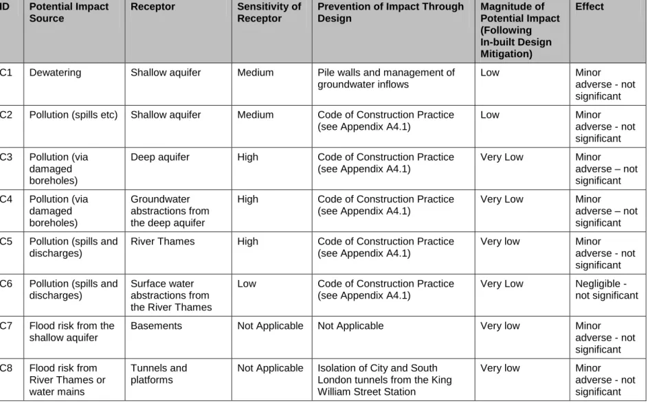
Table 13.5: Summary of Demolition and Construction Effects
ID Potential Impact Source
Receptor Sensitivity of Receptor
Prevention of Impact Through Design Magnitude of Potential Impact (Following In-built Design Mitigation) Effect
C1 Dewatering Shallow aquifer Medium Pile walls and management of groundwater inflows
Low Minor
adverse - not significant C2 Pollution (spills etc) Shallow aquifer Medium Code of Construction Practice
(see Appendix A4.1)
Low Minor adverse - not significant C3 Pollution (via damaged boreholes)
Deep aquifer High Code of Construction Practice (see Appendix A4.1)
Very Low Minor adverse – not significant C4 Pollution (via damaged boreholes) Groundwater abstractions from the deep aquifer
High Code of Construction Practice (see Appendix A4.1)
Very Low Minor
adverse – not significant C5 Pollution (spills and
discharges)
River Thames High Code of Construction Practice (see Appendix A4.1)
Very low Minor adverse - not significant C6 Pollution (spills and
discharges)
Surface water abstractions from the River Thames
Low Code of Construction Practice (see Appendix A4.1)
Very Low Negligible - not significant C7 Flood risk from the
shallow aquifer
Basements Not Applicable Not Applicable Very low Minor adverse - not significant C8 Flood risk from
River Thames or
Tunnels and platforms
Not Applicable Isolation of City and South London tunnels from the King
Very low Minor adverse - not
Permanent and Operational Effects
13.6.15 The potential operational phase impacts and assessment of effects are discussed below and a summary is provided in Table 13.6.
Pollution of the River Thames
13.6.16 There is little potential for direct pollution of the River Thames from waste water generated during operation of the BSCU because the drainage waters will be discharged into the Thames Water sewerage network. The potential magnitude of impact is assessed to be very low and the importance of the River Thames is assessed to be high. Therefore operation of the BSCU is deemed to have a minor adverse effect on the River Thames and a negligible effect on surface water abstractions, which are not significant.
Flood Risk from the Aquifers
13.6.17 As stated earlier, there is some potential for new structures to raise local groundwater levels up-gradient of obstructions to flow. However, this will have a very low impact and overall the effects are assessed as minor adverse and not significant.
Flood Risk from the River Thames or Water Mains
13.6.18 As stated earlier, permanent protective measures will be introduced to ensure that risk of flooding through an accidental pathway between the River Thames or a damaged water main and the City and South London tunnel is minimised. As a result, the potential magnitude of impact is assessed to be very low, and the overall effect will be minor adverse and not significant.
13.6.19 Table 13.6 contains a summary of operational effects prior to additional mitigation.
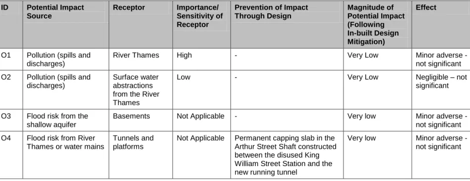
Table 13.6: Summary of Operational Effects ID Potential Impact Source Receptor Importance/ Sensitivity of Receptor Prevention of Impact Through Design Magnitude of Potential Impact (Following In-built Design Mitigation) Effect
O1 Pollution (spills and discharges)
River Thames High - Very Low Minor adverse -
not significant O2 Pollution (spills and
discharges)
Surface water abstractions from the River Thames
Low - Very Low Negligible – not
significant
O3 Flood risk from the shallow aquifer
Basements Not Applicable - Very low Minor adverse - not significant O4 Flood risk from River
Thames or water mains
Tunnels and platforms
Not Applicable Permanent capping slab in the Arthur Street Shaft constructed between the disused King William Street Station and the new running tunnel
Very low Minor adverse - not significant
13.7
Mitigation
13.7.1 The assessment of effects following reduction by incorporated mitigation
indicates there are no predicted significant effects that require further mitigation measures.
13.8
Residual Effects
13.8.1 The assessment of effects following reduction by incorporated mitigation
indicates there are no predicted significant effects that require further mitigation measures. Therefore the residual effects are the same as those in Tables 13.5 and 13.6.
13.9
Inter-relationships and Cumulative Effects
13.9.1 As required by Schedule 1 of the TWA Rules, this assessment also has regard to cumulative effects. It is important to consider how the effects may combine with one another (inter-relationships) and with those of other proposed
development projects in the vicinity (cumulative effects). Construction Effects
13.9.2 Other proposed developments in the area, including the OSD as proposed for the site in the recent planning application granted permission in July 2014, are outlined in Chapter 17: Inter-relationships and Cumulative Effects and they largely comprise demolition of existing buildings followed by redevelopment. Most of the developments are at least 80m from the BSCU Work Sites. Assuming best working practices as required by the City of London Corporation, significant cumulative effects are not expected.
13.9.3 The proposed development at 33 King William Street is adjacent to the Arthur Street Shaft and involves demolition of the existing buildings and
redevelopment to provide a new office building at basement, lower ground, ground and nine upper floors plus roof plant. As there are basement works it is possible that dewatering of the shallow aquifer might be required. Construction is planned for completion during 2015, compared with construction of the BSCU commencing in 2016. Even should an overlap develop, there are no significant cumulative effects anticipated.
Permanent and Operational Effects
13.9.4 No permanent and operational cumulative effects associated with other
developments in the area have been identified with respect to water resources and flood risk.
13.10 Assumptions and Limitations
13.10.1 The numerical groundwater model developed to inform the assessment is a simplification of the likely actual groundwater conditions in the shallow aquifer. It is anticipated that the hydraulic properties of the superficial deposits could vary considerably particularly with variable made ground thickness and
characteristics. The presence of existing basements and deep foundations may already partition the shallow aquifer into discrete blocks. This will prevent
uniform groundwater flow across the area and water levels may vary
significantly over short distances. These aspects are not incorporated within the groundwater model, although it is considered that they would not materially affect the conclusions within this chapter.
13.11 Conclusions
13.11.1 A FRA has been completed for the BSCU in line with the requirements of the
NPPF and also to assist with demonstrating a sustainable development as per the Core Strategy. The BSCU is at low risk of fluvial flooding and other flood risk sources have been mitigated through design under demolition, construction and operational phases.
13.11.2 The assessment has considered the Environment Agency GP3, EU Water Framework Directive and other relevant policy and legislation. It has been assessed that the prevention of impact through design has resulted in no significant effects with respect to water resources and flood risk.
References
City of London Corporation, 2013. Code of Practice for Deconstruction and Construction
Sites (Seventh Edition, May 2013).
Drain London, August 2011. Surface Water Management Plan. City of London. Environment Agency, October 2012. Good Practice for Decommissioning Redundant
Boreholes and Wells.
Environment Agency, 2012. Management of the London Basin Chalk Aquifer. Status Report 2012.
Fugro Engineering Services Limited, September 2006. Walbrook, London Site
Investigation Additional Works. Final Factual Report. LUSTN-0008798-RPT-002620 and
Fugro Engineering Services Limited, June 2006. Walbrook, London – Site Investigation. Final Factual Report. LUSTN-0008798-RPT-002621.
Halcrow, May 2012. Strategic Flood Risk Assessment. City of London.
Hyder Consulting Ltd, October 2012. Geotechnical baseline report. Bank Station Capacity Upgrade Project. LUSTN-0008798-RPT-002364 v0.2.
London Underground Limited, April 2012. Abstraction and historic wells. Current status. Bank Station Capacity Upgrade. LUSTN-0008798-STR-002051.
Mott MacDonald, August 2011. Water Resources Baseline Report. Bank Station Capacity Upgrade Project. N133-BCR-MMD-00-Z-DC-N-0007-S0-0.1.
Norwest Holst Limited, November 2007. Report on a Ground Investigation at NM