Left-Turn Accommodations at
Unsignalized Intersections
NCHRP
REPORT 745
NATIONAL
COOPERATIVE
HIGHWAY
RESEARCH
PROGRAM
OFFICERS
Chair: Deborah H. Butler, Executive Vice President, Planning, and CIO, Norfolk Southern Corporation, Norfolk, VA ViCe Chair: Kirk T. Steudle, Director, Michigan DOT, Lansing
exeCutiVe DireCtor: Robert E. Skinner, Jr., Transportation Research Board
MEMBERS
Victoria A. Arroyo, Executive Director, Georgetown Climate Center, and Visiting Professor, Georgetown University Law Center, Washington, DC Scott E. Bennett, Director, Arkansas State Highway and Transportation Department, Little Rock
William A. V. Clark, Professor of Geography (emeritus) and Professor of Statistics (emeritus), Department of Geography, University of California,
Los Angeles
James M. Crites, Executive Vice President of Operations, Dallas–Fort Worth International Airport, TX John S. Halikowski, Director, Arizona DOT, Phoenix
Paula J. C. Hammond, Secretary, Washington State DOT, Olympia
Michael W. Hancock, Secretary, Kentucky Transportation Cabinet, Frankfort
Susan Hanson, Distinguished University Professor Emerita, School of Geography, Clark University, Worcester, MA Steve Heminger, Executive Director, Metropolitan Transportation Commission, Oakland, CA
Chris T. Hendrickson, Duquesne Light Professor of Engineering, Carnegie Mellon University, Pittsburgh, PA
Jeffrey D. Holt, Managing Director, Bank of Montreal Capital Markets, and Chairman, Utah Transportation Commission, Huntsville, UT Kevin L. Keith, Missouri DOT, Jefferson City
Gary P. LaGrange, President and CEO, Port of New Orleans, LA Michael P. Lewis, Director, Rhode Island DOT, Providence Joan McDonald, Commissioner, New York State DOT, Albany
Donald A. Osterberg, Senior Vice President, Safety and Security, Schneider National, Inc., Green Bay, WI Steve Palmer, Vice President of Transportation, Lowe’s Companies, Inc., Mooresville, NC
Sandra Rosenbloom, Director, Innovation in Infrastructure, The Urban Institute, Washington, DC Henry G. (Gerry) Schwartz, Jr., Chairman (retired), Jacobs/Sverdrup Civil, Inc., St. Louis, MO
Kumares C. Sinha, Olson Distinguished Professor of Civil Engineering, Purdue University, West Lafayette, IN
Daniel Sperling, Professor of Civil Engineering and Environmental Science and Policy; Director, Institute of Transportation Studies;
University of California, Davis
Gary C. Thomas, President and Executive Director, Dallas Area Rapid Transit, Dallas, TX Phillip A. Washington, General Manager, Regional Transportation District, Denver, CO
EX OFFICIO MEMBERS
Rebecca M. Brewster, President and COO, American Transportation Research Institute, Smyrna, GA Anne S. Ferro, Administrator, Federal Motor Carrier Safety Administration, U.S. DOT
LeRoy Gishi, Chief, Division of Transportation, Bureau of Indian Affairs, U.S. Department of the Interior, Washington, DC John T. Gray II, Senior Vice President, Policy and Economics, Association of American Railroads, Washington, DC Michael P. Huerta, Administrator, Federal Aviation Administration, U.S. DOT
Joung Ho Lee, Associate Director for Finance and Business Development, American Association of State Highway and Transportation Officials,
and Chair, TRB Young Members Council, Washington, DC
David T. Matsuda, Administrator, Maritime Administration, U.S. DOT
Michael P. Melaniphy, President and CEO, American Public Transportation Association, Washington, DC Victor M. Mendez, Administrator, Federal Highway Administration, U.S. DOT
Robert J. Papp (Adm., U.S. Coast Guard), Commandant, U.S. Coast Guard, U.S. Department of Homeland Security Cynthia L. Quarterman, Administrator, Pipeline and Hazardous Materials Safety Administration, U.S. DOT Peter M. Rogoff, Administrator, Federal Transit Administration, U.S. DOT
David L. Strickland, Administrator, National Highway Traffic Safety Administration, U.S. DOT Joseph C. Szabo, Administrator, Federal Railroad Administration, U.S. DOT
Polly Trottenberg, Under Secretary for Policy, U.S. DOT
Robert L. Van Antwerp (Lt. General, U.S. Army), Chief of Engineers and Commanding General,
U.S. Army Corps of Engineers, Washington, DC
Barry R. Wallerstein, Executive Officer, South Coast Air Quality Management District, Diamond Bar, CA Gregory D. Winfree, Acting Administrator, Research and Innovative Technology Administration, U.S. DOT
Frederick G. (Bud) Wright, Executive Director, American Association of State Highway and Transportation Officials, Washington, DC
NCHRP
REPORT 745
Left-Turn Accommodations at
Unsignalized Intersections
Kay Fitzpatrick Marcus A. Brewer William L. EiseleTexas a&M TransporTaTion insTiTuTe College Station, TX Herbert S. Levinson Wallingford, CT Jerome S. Gluck Matthew R. Lorenz aeCoM New York, NY Subscriber Categories
Highways • Design • Safety and Human Factors
T R A N S P O R T A T I O N R E S E A R C H B O A R D
WASHINGTON, D.C.
2013
www.TRB.org
Research sponsored by the American Association of State Highway and Transportation Officials in cooperation with the Federal Highway Administration
RESEARCH PROGRAM
Systematic, well-designed research provides the most effective approach to the solution of many problems facing highway administrators and engineers. Often, highway problems are of local interest and can best be studied by highway departments individually or in cooperation with their state universities and others. However, the accelerating growth of highway transportation develops increasingly complex problems of wide interest to highway authorities. These problems are best studied through a coordinated program of cooperative research.
In recognition of these needs, the highway administrators of the American Association of State Highway and Transportation Officials initiated in 1962 an objective national highway research program employing modern scientific techniques. This program is supported on a continuing basis by funds from participating member states of the Association and it receives the full cooperation and support of the Federal Highway Administration, United States Department of Transportation.
The Transportation Research Board of the National Academies was requested by the Association to administer the research program because of the Board’s recognized objectivity and understanding of modern research practices. The Board is uniquely suited for this purpose as it maintains an extensive committee structure from which authorities on any highway transportation subject may be drawn; it possesses avenues of communications and cooperation with federal, state and local governmental agencies, universities, and industry; its relationship to the National Research Council is an insurance of objectivity; it maintains a full-time research correlation staff of specialists in highway transportation matters to bring the findings of research directly to those who are in a position to use them.
The program is developed on the basis of research needs identified by chief administrators of the highway and transportation departments and by committees of AASHTO. Each year, specific areas of research needs to be included in the program are proposed to the National Research Council and the Board by the American Association of State Highway and Transportation Officials. Research projects to fulfill these needs are defined by the Board, and qualified research agencies are selected from those that have submitted proposals. Administration and surveillance of research contracts are the responsibilities of the National Research Council and the Transportation Research Board.
The needs for highway research are many, and the National Cooperative Highway Research Program can make significant contributions to the solution of highway transportation problems of mutual concern to many responsible groups. The program, however, is intended to complement rather than to substitute for or duplicate other highway research programs.
Published reports of the
NATIONAL COOPERATIVE HIGHWAY RESEARCH PROGRAM
are available from:
Transportation Research Board Business Office
500 Fifth Street, NW Washington, DC 20001
and can be ordered through the Internet at: http://www.national-academies.org/trb/bookstore
Printed in the United States of America Project 03-91
ISSN 0077-5614 ISBN 978-0-309-25898-2
Library of Congress Control Number 2013934581 © 2013 National Academy of Sciences. All rights reserved.
COPYRIGHT INFORMATION
Authors herein are responsible for the authenticity of their materials and for obtaining written permissions from publishers or persons who own the copyright to any previously published or copyrighted material used herein.
Cooperative Research Programs (CRP) grants permission to reproduce material in this publication for classroom and not-for-profit purposes. Permission is given with the understanding that none of the material will be used to imply TRB, AASHTO, FAA, FHWA, FMCSA, FTA, or Transit Development Corporation endorsement of a particular product, method, or practice. It is expected that those reproducing the material in this document for educational and not-for-profit uses will give appropriate acknowledgment of the source of any reprinted or reproduced material. For other uses of the material, request permission from CRP.
NOTICE
The project that is the subject of this report was a part of the National Cooperative Highway Research Program, conducted by the Transportation Research Board with the approval of the Governing Board of the National Research Council.
The members of the technical panel selected to monitor this project and to review this report were chosen for their special competencies and with regard for appropriate balance. The report was reviewed by the technical panel and accepted for publication according to procedures established and overseen by the Transportation Research Board and approved by the Governing Board of the National Research Council.
The opinions and conclusions expressed or implied in this report are those of the researchers who performed the research and are not necessarily those of the Transportation Research Board, the National Research Council, or the program sponsors.
The Transportation Research Board of the National Academies, the National Research Council, and the sponsors of the National Cooperative Highway Research Program do not endorse products or manufacturers. Trade or manufacturers’ names appear herein solely because they are considered essential to the object of the report.
authority of the charter granted to it by the Congress in 1863, the Academy has a mandate that requires it to advise the federal government on scientific and technical matters. Dr. Ralph J. Cicerone is president of the National Academy of Sciences.
The National Academy of Engineering was established in 1964, under the charter of the National Academy of Sciences, as a parallel organization of outstanding engineers. It is autonomous in its administration and in the selection of its members, sharing with the National Academy of Sciences the responsibility for advising the federal government. The National Academy of Engineering also sponsors engineering programs aimed at meeting national needs, encourages education and research, and recognizes the superior achievements of engineers. Dr. Charles M. Vest is president of the National Academy of Engineering.
The Institute of Medicine was established in 1970 by the National Academy of Sciences to secure the services of eminent members of appropriate professions in the examination of policy matters pertaining to the health of the public. The Institute acts under the responsibility given to the National Academy of Sciences by its congressional charter to be an adviser to the federal government and, on its own initiative, to identify issues of medical care, research, and education. Dr. Harvey V. Fineberg is president of the Institute of Medicine.
The National Research Council was organized by the National Academy of Sciences in 1916 to associate the broad community of science and technology with the Academy’s purposes of furthering knowledge and advising the federal government. Functioning in accordance with general policies determined by the Academy, the Council has become the principal operating agency of both the National Academy of Sciences and the National Academy of Engineering in providing services to the government, the public, and the scientific and engineering communities. The Council is administered jointly by both Academies and the Institute of Medicine. Dr. Ralph J. Cicerone and Dr. Charles M. Vest are chair and vice chair, respectively, of the National Research Council.
The Transportation Research Board is one of six major divisions of the National Research Council. The mission of the Transporta-tion Research Board is to provide leadership in transportaTransporta-tion innovaTransporta-tion and progress through research and informaTransporta-tion exchange, conducted within a setting that is objective, interdisciplinary, and multimodal. The Board’s varied activities annually engage about 7,000 engineers, scientists, and other transportation researchers and practitioners from the public and private sectors and academia, all of whom contribute their expertise in the public interest. The program is supported by state transportation departments, federal agencies including the component administrations of the U.S. Department of Transportation, and other organizations and individu-als interested in the development of transportation. www.TRB.org
CRP STAFF FOR NCHRP REPORT 745
Christopher W. Jenks, Director, Cooperative Research Programs Crawford F. Jencks, Deputy Director, Cooperative Research Programs B. Ray Derr, Senior Program Officer
Andréa Harrell, Senior Program Assistant Eileen P. Delaney, Director of Publications Margaret B. Hagood, Editor
NCHRP PROJECT 03-91 PANEL
Field of Traffic—Area of Operations and Control Brian K. Gage, Minnesota DOT, St. Paul, MN (Chair) Gary Sokolow, Florida DOT, Tallahassee, FL Michael J. Fuess, Nevada DOT, Sparks, NV
Chris W. Huffman, Kansas and Missouri Certified General Property Appraiser, Lawrence, KS Robert L. Irish, Kentucky Transportation Cabinet, Frankfort, KY
Alejandra L. Medina-Flintsch, Virginia Tech Transportation Institute, Blacksburg, VA Vergil G. Stover, Texas A&M University, College Station, TX
Wei Zhang, FHWA Liaison Richard A. Cunard, TRB Liaison
AUTHOR ACKNOWLEDGMENTS
The research reported herein was performed under NCHRP Project 3-91 by the Texas Transportation Institute (TTI), Texas A&M University. Texas A&M Research Foundation was the contractor for this study. Kay Fitzpatrick, Senior Research Engineer, TTI, was the Principal Investigator. The other authors of this report are: Marcus A. Brewer (Assistant Research Engineer, TTI), Herbert S. Levinson (Principal, Herbert S. Levinson, Transportation Consultant), Jerome Gluck (Associate Vice President, AECOM), Matthew R. Lorenz (Senior Traffic Engineer, AECOM), and William L. Eisele (Research Engineer, TTI). The work was performed under the general supervision of Dr. Fitzpatrick.
The authors wish to acknowledge those who contributed to this research, including (but are not limited to): Yunlong Zhang, Assistant Professor, Texas A&M University and Assistant Research Scientist, TTI; Wyndylyn von Zharen, Professor, Texas A&M University at Galveston; Vichika Iragavarapu, Assistant Transportation Researcher, TTI; Eun Sug Park, Associate Research Scientist, TTI; Richard Calvache, Field Supervisor, AECOM; Robert Medland, Vice-President, Traffic Research and Analysis, Inc.; Lisa Walters, Administrative Assistant, Traffic Research and Analysis, Inc.; Joseph Kaluha, Senior Manual Count Field Supervisor, Traffic Research and Analysis, Inc.; Will Fox, ATR Field Technician II, Traffic Research and Analysis, Inc.; Marcia Halilton, Manual Count Field Supervisor, Traffic Research and Analysis, Inc.; Anthony Voigt, Program Manager, TTI; Byung-Jung Park, Graduate Student, Texas A&M University; Colleen Dau, Lead Office Assistant, TTI; Christopher Senesi, Texas A&M University, Undergraduate Fellows Program; Dan Walker, Assistant Research Specialist, TTI; Feng Wan, Graduate Student, Texas A&M University; James Campbell, Student Worker, TTI; James Robertson, Graduate Student, Texas A&M University; Jesse Stanley, Research Associate, TTI; Jordan Main, Student Worker, TTI; Rickilee Mercer, Student Worker, TTI; Mike Cynecki, City of Phoenix, AZ; Kerry Wilcoxon, City of Phoenix, AZ; Troy Rother, City of College Station, TX; LuAnn Roth, Kansas DOT; Lloyd Smith, Harris County, TX; and Narciso Lira III, City of Pearland, TX.
By B. Ray Derr
Staff Officer
Transportation Research Board
This report presents guidance for the selection and design of left-turn accommodations at unsignalized intersections. Eleven case studies of typical situations illustrate the use of the guidance. The report will be useful to geometric designers and traffic engineers that deal with unsignalized intersections.
Maximizing the potential capacity of existing roadways is a priority in light of grow-ing traffic demands and the diminishgrow-ing resources to develop more capacity. Left turns at unsignalized intersections, including driveways, cause delay and may reduce safety. The decision to install a left-turn accommodation is a complex one as state and local trans-portation agencies weigh the left-turn demand, the cost of the accommodation, and the anticipated operational and safety benefits. Clear and consistent application of left-turn accommodations is important for mitigating the impacts of left turns, both for reconstruc-tion projects and for the permitting of new access points.
In NCHRP Project 03-91, the Texas A&M Transportation Institute and their research team interviewed state and local elected officials and transportation agency administrators, business owners, and developers to determine their concerns related to providing left-turn accommodations at unsignalized intersections and identify performance measures that may influence these decisions. They then developed a process for determining whether a left-turn accommodation is justified at an unsignalized intersection and, if so, the types of accommodations that are appropriate. The process considers safety, operational efficiency, and construction costs. Design guidance was then developed for typical left-turn accom-modations. The likely benefits and impacts of accommodations are described.
This report includes eleven design examples illustrating use of the guidance. These exam-ples are based on actual locations where left-turn treatments were considered, evaluated, and/or installed. Two of the examples involve analysis of a proposed development.
The contractor’s final report providing background information for the project is avail-able on the TRB website. In addition to describing the work that was done, Appendix F presents a legal review of the impact of essential nexus and rough proportionality on devel-opment considerations.
1
Summary
3
Chapter 1
Introduction
3 Background of Study
4 Purpose and Scope of Guidelines 4 Organization of Design Guide
5
Chapter 2
Planning and Design Process
5 Introduction
5 Assemble Basic Information 5 Basic Information 6 Volume
6 Speed
6 Crash History 6 Delay
7 Establish and Apply Decision Criteria 8 Apply Left-Turn Lane Warrants 8 Warrants
8 Source of Warrants—Benefit-Cost Approach 11 Prepare Designs
12
Chapter 3
Geometric Design
12 Introduction
12 Selection of Design Speed 12 Selection of Design Vehicle
13 Desirable and Minimum Lane Widths 13 Tapers
14 Tapers for Left Turns (Bay Taper)
15 Tapers for Through Traffic (Approach Taper) 16 Deceleration Length
17 Vehicle Storage Length 19 Sight Distance
19 Median Design
20 Channelization and Offset 20 Bypass Lanes 22 Pedestrian Storage
23
Chapter 4
Traffic Controls and Illumination
23 Introduction 23 Signs 23 Sign Types 23 Sign Design25 Application Guidelines 26 Pavement Markings 26 Overview 26 Types of Markings 26 Applications 27 Illumination 27 Overview 27 Types of Illumination 28 Intensity 28 Location
29 Provision for Future Signalization 29 Power
29 Location of Signal Poles and Controller Cabinet 29 Vehicle Detection
29 Access Management
30
Chapter 5
Design Examples
30 Introduction
30 Design Application #1: Installation of Exclusive Left-Turn Lanes at an Unsignalized Intersection in a Suburban Fringe Area 30 Context
31 Design Considerations and Analysis 32 Design Result
32 Design Application #2: Installation of an Exclusive Left-Turn Lane
at an Unsignalized Intersection Between a Local Street and a State Highway 32 Context
32 Design Request
34 Design Considerations and Analysis 34 Design Result
34 Design Application #3: Addition of a Left-Turn Lane as Part
of a “Road Diet” Treatment (Conversion of a Four-Lane Cross Section to a Three-Lane Cross Section)
34 Context 34 Design Request
34 Design Considerations and Analysis 35 Design Result
35 Design Application #4: Installation of Left-Turn Lanes at an Unsignalized Rural Intersection Between a State Highway and a Local Road
36 Context 36 Design Request
36 Design Considerations and Analysis 37 Design Result
37 Design Application #5: Installation of Unsignalized “J-Turn” Intersections Along a State Highway
37 Context 38 Design Request
38 Design Considerations and Analysis 39 Design Result
at an Unsignalized Intersection Between a Local Street and a State Highway 40 Context
40 Design Request
40 Design Considerations and Analysis 40 Design Result
41 Design Application #7: Installation of Left-Turn Lanes at an Unsignalized Rural Intersection Between a State Highway and a County Road 41 Context
42 Design Request
42 Design Considerations and Analysis 43 Design Result
43 Design Application #8: Follow-Up Traffic Studies to Verify the Need for an Unsignalized Left-Turn Lane in Conjunction
with a Proposed Development 43 Context
43 Design Request
43 Design Considerations and Analysis 44 Design Result
45 Design Application #9: Installation of Left-Turn Lanes at Unsignalized Intersections in Conjunction with a Proposed Development
45 Context 45 Design Request
45 Design Considerations and Analysis 46 Design Result
46 Design Application #10: Installation of an Exclusive Left-Turn Lane at an Unsignalized Suburban Intersection Between a State Highway and a Local Street
46 Context 47 Design Request
47 Design Considerations and Analysis 48 Design Result
48 Design Example #11: Installation of Exclusive Left-Turn Lanes and a Traffic Signal at an Unsignalized Intersection Between a Local Street and a State Highway
49 Context 49 Design Request
49 Design Considerations and Analysis 50 Design Result
51
References
Note: Many of the photographs, figures, and tables in this report have been converted from color to grayscale for printing. The electronic version of the report (posted on the Web at www.trb.org) retains the color versions.
Left-Turn Accommodations
at Unsignalized Intersections
NCHRP Project 3-91, “Left-Turn Accommodations at Unsignalized Intersections,” had two primary research goals:
• Develop an objective and clear process for the selection of left-turn accommodations at unsignalized intersections and
• Provide guidance on the design of these accommodations.
The second of those goals led to the decision to create this design guide to facilitate the distri-bution of findings from that project and to assist practitioners in their efforts when installing, or deciding when to install, left-turn lanes at unsignalized intersections.
Left-turn movements at unsignalized intersections and driveways, especially those that are made from lanes that are shared with through traffic, cause delays and adversely impact safety. The warrants used by many jurisdictions for when to provide left-turn lanes are based on volume thresholds and a queuing model introduced in research from the mid-1960s. Recent research has indicted that many of the assumptions used in those warrants are dated and need to be reexamined.
The left-turn lane warrants developed from NCHRP Project 3-91 include consideration of the following:
• Rural or urban/suburban environment,
• Number of lanes on the major roadway,
• Number of approaches to the intersection,
• Peak hour left-turn lane volume, and
• Major roadway volume.
This design guide was developed with a focus on practitioner use. It does not contain a com-prehensive description of NCHRP Project 3-91 or how the conclusions were developed. Rather, it focuses on designs and traffic control treatments for left-turn lanes. Details of the research project are documented in the final research report, which is separate from this design guide.
The design guide discusses the basic information (e.g., traffic volumes, speeds, crash history, and delay or gap acceptance data) a practitioner needs to make a decision on whether to install a left-turn lane and how the practitioner can compile that information. It also sets forth a process by which the practitioner can establish and apply design criteria, both in the decision to install a left-turn lane and in the process of determining the specific design elements for that lane.
Warrants for installing left-turn lanes are provided in tabular and graphical form for rural two-lane roadways, rural four-lane roadways, and urban/suburban arterials. Warrants for bypass lanes on rural two-lane roadways also are included. The volume thresholds for these warrants are
typically lower than those described in various states’ manuals and other guidance documents, with installations warranted for as few as five left-turning vehicles in the peak hour, depending on the opposing through volume. These warrants are based on a benefit-cost analysis conducted in NCHRP Project 3-91.
The design guide also contains recommendations for appropriate dimensions for specific design elements, such as:
• Lane width (as wide as the adjacent through lane, but at least 10 ft),
• Taper length (8:1 [L:T] for design speeds up to 30 mph and 15:1 [L:T] for design speeds of 50 mph) and type (bay taper or approach taper; “shadowed” or direct entry),
• Deceleration length (preference for no deceleration in the through lane, though 10 mph may be allowed), and
• Storage length (enough to store expected number of design vehicles during a critical period, but at least 40–50 ft, or two passenger car lengths).
A discussion of intersection sight distance, median design, and channelization and offset are included, as well as general principles for bypass lane design and pedestrian accommodation.
Traffic control devices are important complements to the geometric design of unsignalized intersections. The guide discusses commonly used signs, markings, and illumination, based on guidance from the MUTCD and lighting guides from AASHTO, ITE, and IESNA. The appropri-ate types (e.g., regulatory, warning, guide), sizes, and placement of signs are described, as are application guidelines for both signs and markings. Commonly used principles related to type, intensity, and location of lighting are explained, and provisions for accommodating future sig-nalization are also included.
The guide also contains a series of 11 design example case studies, based on actual inter sections where left-turn treatments were evaluated and installed. These case studies include installations of exclusive left-turn lanes in developing areas, a left-turn lane as part of a road diet program, a J-turn intersection, a bypass lane (or “passing blister”), and a signalized left-turn lane. Design examples provide the practitioner with “real-world” scenarios that are similar to those the prac-titioner would actually encounter, along with possible solutions and the methods by which those solutions can be evaluated and installed.
Background of Study
Left-turn movements at unsignalized intersections, includ-ing driveways—especially movements that are made from lanes that are shared with through traffic—cause delays and adversely impact safety. The warrants used by many jurisdic-tions for when to provide left-turn lanes are based on volume thresholds and a queuing model introduced in research from the mid-1960s. Recent research has indicted that many of the assumptions used in those warrants are dated and need to be reexamined. Part of the concerns regarding the existing warrants were other factors that should be considered when researching left-turn lane warrants, such as the cost element, particularly when right-of-way issues are involved, and the rational nexus, when the left-turn accommodation may be related to a proposed new development.
These and related issues led to the creation of NCHRP Project 3-91, “Left-Turn Accommodations at Unsignalized Intersections.” The project had two primary research goals:
• Develop an objective and clear process for the selection of left-turn accommodations at unsignalized intersections and
• Provide guidance on the design of these accommodations. The second of these goals led to the decision to create this design guide to facilitate the distribution of findings from that project and to assist practitioners in their efforts when installing, or deciding when to install, left-turn lanes at unsignalized intersections. Documentation of how the left-turn lane warrants were developed is contained in the final research report from the project (1).
The left-turn lane warrants developed from NCHRP Proj-ect 3-91 include consideration of the following:
• Rural or urban/suburban environment,
• Number of lanes on the major roadway,
• Number of approaches to the intersection,
• Peak-hour left-turn lane volume, and
• Major roadway volume.
Technical warrants are an important element of the decision-making process; however, other factors also should be considered when deciding whether to install a left-turn lane, including:
• Sight distance relative to the position of the driver and
• Design consistency within the corridor.
These factors should be considered in conjunction with the numerical warrants. For example, if volumes indicate that a left-turn lane is not warranted but there is insufficient sight distance at the location for the left-turning vehicles, then the left-turn lane should be considered along with other poten-tial changes (e.g., remove sight obstructions, realign the high-way, etc.).
The practitioner must consider a number of issues when making decisions about planning and designing the lane. Some of these issues include:
• Design vehicle,
• Width of the turn lane,
• Need for an island of appropriate size for pedestrian refuge,
• Pedestrian facilities,
• Length for deceleration,
• Taper/transition length,
• Length storage for turning vehicles,
• Signage,
• Pavement markings,
• Illumination,
• Position of driveways/intersections in the vicinity of the left-turn lane, and
C h a p t e r 1
Introduction
• Potential of signalizing the intersection in the foreseeable future.
Proper consideration of these issues, and the ability to make informed decisions about them, will improve the likelihood that a left-turn lane is installed at an appropriate location and that its design will lead to improved operations during its ser-vice life.
Purpose and Scope of Guidelines
The design guide was developed with a focus on practi-tioner use. It does not contain a comprehensive description of the research project or how the conclusions were devel-oped. Rather, it focuses on designs and traffic control treat-ments for left-turn lanes. Details about the research project are documented elsewhere (1).
Organization of Design Guide
This design guide has five chapters, including this intro-ductory chapter. Chapter 2 discusses key steps in the plan-ning and design process and how to compile and use the necessary information to complete those steps. It also con-tains the warrants the practitioner should consider when deciding whether to install a left-turn lane at a particular location. Chapter 3 provides a summary of key geometric design criteria and considerations specific to left-turn lanes at unsignalized intersections. Chapter 4 discusses appropriate traffic control devices and illumination, including provisions for future signalization. Chapter 5 contains a variety of case studies. The practitioner can refer to these case studies for examples of prior left-turn lane installations, which illustrate decisions and considerations made by other practitioners in similar situations.
Introduction
Before installing a left-turn lane (or any other roadway improvement), it is necessary to consider the characteristics of the location where it would be installed. These characteristics guide the practitioner’s decisions about whether to install the lane and what specific design criteria need to be emphasized to optimize the operation of the lane at that location. This chapter sets forth guidelines for establishing and applying decision cri-teria for providing left-turn lanes at unsignalized intersections. These guidelines can be useful to transportation agencies in planning new roadways and upgrading existing facilities.
The information in this chapter is closely related to that presented in Chapter 3 because much of the information nec-essary to make the fundamental decision to install a left-turn lane is also used in the subsequent decisions about the details of the design of the lane. Therefore, the practitioner should consider the material in that chapter in conjunction with the following sections when making decisions early in the pro-cess of planning and designing a left-turn lane installation.
Assemble Basic Information
There are some common reasons that practitioners consider the installation of a left-turn lane to improve an intersection.
• Speeds are too high to safely make left turns to or from a particular roadway.
• There is a trend or pattern of crashes involving left-turning vehicles, or rear-end or sideswipe/weaving crashes as through vehicles interact with queued vehicles.
• Drivers have to wait a long time to make a left turn.
• There are a high number of left-turning vehicles.
The thresholds that practitioners apply to these situations (e.g., what speed is “too high”) can vary depending on local or state guidelines, previous experience with left-turn lanes in that
area, and input from local stakeholders. In addition, the per-ception of these issues (whether real or imagined) also can ini-tiate a review of an intersection, particularly when it comes to speed and/or crashes. As a result, basic information needed to assess the validity of those issues is commonly collected at the start of the planning process. In addition to the items discussed below, information also is needed regarding other conditions in the area, such as how left turns are treated at other locations along the corridor in question and the spacing between a loca-tion under study and upstream and downstream traffic signals. The basic information needed for use with the developed left-turn lane warrants includes:
• Development (rural or urban/suburban),
• Number of lanes on the major roadway (two or four),
• Number of approaches (three legs or four legs),
• Peak-hour left-turn lane volume (left-turn vehicles per hour), and
• Major roadway volume (vehicles per hour per lane). Other information traditionally used in traffic engineering studies includes:
• Volume,
• Speed,
• Crashes, and
• For selected locations delay and/or gap acceptance.
Basic Information
The basic geometry of the intersection needed for use with the warrants is the number of lanes on the major roadway and the number of approaches to the intersection. The num-ber of approaches and the development type (rural or urban/ suburban) are included in the warrants because the crash prediction methodology used to develop the warrants varied by these features. Rural crash prediction equations vary by
C h a p t e r 2
number of lanes on the major roadway, so the warrants for rural highways also vary by number of lanes.
Volume
The peak-hour left-turn volume and major road volume are needed for use in the left-turn warrants.
Quantifying the overall traffic volumes at a candidate intersection can provide a better understanding of the condi-tions at a site. An aggregate volume count can be conducted with a speed study if automated traffic counters are used. The two studies can then cover the same amount of time and be reviewed for patterns over time of day or day of the week.
However, it is also important that these volumes are identi-fied not only by time of day, but by turning movement. A com-prehensive turning-movement count quantifies the number of vehicles on each leg of the intersection that turned left, turned right, or proceeded straight through the intersection. These turning-movement counts must be done manually or be collected by video and later manually reviewed. While this type of count is more resource intensive, it provides the infor-mation needed to know what the left-turn demand is on each approach, and it also identifies the opposing traffic volumes through which turning drivers must complete their turning maneuvers. When analyzing the existing counts, it is impor-tant to consider growth in future left-turn demand associated with plans for future development.
If the lane is being considered because of a particular traf-fic generator (e.g., a sporting or concert venue or a seasonal event), then the volume data should be collected when that generator is expected to produce the traffic being considered.
Speed
A speed study to determine the prevailing speeds at a partic-ular intersection is a straightforward way to evaluate the effect of speeds on turning movements. Commonly, these speeds are collected through the use of automated traffic counters, usu-ally deployed at selected spot locations on each approach (and perhaps departure) leg of the intersection. Alternatively, radar or laser speed devices can be used to collect a sample of spot speeds for a particular period of time, such as the peak hour.
Detailed procedures on conducting spot-speed studies can be found in other sources (2). If concerns exist about chang-ing conditions, speed data can be collected on several days or through the course of a week to identify speed patterns over time. An entire week allows the practitioner to see trends on weekdays versus weekends, day versus night, and other time-sensitive comparisons that could influence the decisions related to the left-turn lane.
The result of such a study is a spreadsheet of data show-ing basic speed statistics (e.g., average, minimum, maximum, 85th percentile) for the entire study period as well as other divisions of time (e.g., 24-hour periods, 6-hour periods,
1-hour periods for peak times). These statistics help illustrate patterns and trends in operating speeds at the intersection, which can be used to make informed decisions about the design of the turning lane.
Crash History
If an intersection has a problem (or a perceived problem) with left-turn-related crashes, then a crash study is necessary to determine the extent of the problem. A review of recent crash reports can provide insight into the nature of the prob-lem and how a left-turn lane may be a suitable countermea-sure. For example, if crashes are occurring predominantly on one leg of the intersection, then it may be necessary to install a left-turn lane only on that leg, rather than on multiple legs. Left-turn-related crashes may include rear-end crashes at or near the intersection or driveway as well as sideswipe crashes, especially for multilane streets.
Often a crash study considers the previous 12 months, though a 24- or 36-month study may be useful, particularly if the practitioner desires to estimate the effects of adjacent development or other recent changes at that location. For example, if crashes increased after the completion of a new housing development, then the intersection may need a left-turn lane, a need that did not exist prior to its completion.
Depending on the jurisdiction or the classification of the roadway, there may be an electronic database of crash data that can be searched for information. Use of the electronic database can be helpful in searching through a large num-ber of crashes in a short period of time; however, electronic records typically do not contain the level of detail provided by printed copies of the law enforcement officers’ original reports. The full report shows a diagram of the intersection that includes the movements of vehicles and locations of key objects. The report also contains a narrative of the sequence of events leading to the crash, as the officer states it in his or her own words. The details provided by the diagram and the narrative are extremely valuable in identifying patterns related to crashes and crash history at a given intersection.
Delay
A study of the delay and/or gap acceptance at an intersec-tion can provide useful informaintersec-tion to determine if there is a potential problem that a turn lane can address. If left-turning drivers must wait a lengthy amount of time to com-plete their turns, it can lead to further delay for the drivers waiting in the queue behind them, whether they intend to turn or travel straight through the intersection. A left-turn lane would provide storage for turning vehicles and remove impediments to through vehicles.
A delay study looks at the time it takes vehicles to travel through the intersection under prevailing conditions and
compares it to the amount of time it would take the same vehicles to travel through the intersection under free-flow conditions. A discussion of delay and gap acceptance studies for two-way and all-way stop-controlled intersections, as well as the recommended procedure and equations to use, can be found in the Highway Capacity Manual (3).
It is important to review delay in the context of crashes. Sites with a left-turn crash problem may have high delay, but sites without a crash problem may also have delay because increasing delay can be a precursor to an increasing crash rate. As drivers wait longer to turn, they can become impa-tient and attempt turns when it is not actually safe to do so.
Establish and Apply Decision Criteria
While the practitioner is still early in the planning and design process, the criteria for making decisions about left-turn lane installation need to be defined. In other words, what factors are important for determining the characteristics that the lane needs to have? Some of these factors depend on the issues identified in the previous section; whether some combination of these factors is an influence on the site will partially determine what other factors need to be considered when planning and designing the new lane.
In addition to the basic contributors, other factors might be:
• Access to adjacent development, in conjunction with access management considerations and requirements;
• Available right-of-way;
• Existing roadway width;
• Safety or crash history;
• Consistency with nearby intersections;
• Sight distance restrictions;
• Speed differential concerns;
• Pedestrian traffic;
• Existing or proposed medians; and
• Available budget.
Decisions relating to left-turn installation, particularly for a left-turn lane into a new development, may be governed by access management provisions of the agencies with jurisdic-tion. In order to preserve mobility and provide safety for the traveling public, many transportation agencies have estab-lished regulations and programs to manage access to their roadway network. For access to a new development, state and local agencies typically use access permitting to apply access management standards to guide decisions regarding where and what access would be allowed as well as any restrictions to this access. In general, the regulations are more restrictive for major arterials, the roadways intended to accommodate higher volumes and speeds.
These factors must then be considered in conjunction with the corresponding geometric design criteria and applicable
policies on planning and access management to make appro-priate decisions about specific characteristics of that particular left-turn lane. For example, on an intersection approach under consideration for a left-turn lane, there is a driveway upstream of the intersection where left turns also commonly occur. Vehicles turning into that driveway may also queue in the same through lane and cause confusion both to through drivers and to drivers intending to turn left at the intersection. In order to improve operations for through vehicles and reduce the likeli-hood of delay or rear-end crashes as through vehicles approach queued vehicles turning into the driveway, it may be desirable or preferable to provide a left-turn lane at this location as well. The spacing between the intersection and driveway will be a major consideration in establishing the appropriate treatment. An option may be to extend the left-turn lane upstream from the intersection to the driveway to provide storage for all left-turning vehicles. However, it may also be prudent to completely restrict left-turn access to that driveway through the use of a raised median, where possible, in order to reduce confusion among left-turning drivers; prohibiting turns into the drive-way would prevent the formation of two intermingled queues (one for the driveway and one for the intersection) within the same lane, and it would eliminate the subsequent potential for “jockeying for position” within the left-turn lane and the adja-cent through lane as drivers turning at the intersection try to avoid the queue for the driveway.
The practitioner should identify and list all such influ-encing factors and document them as decisions are made throughout the planning and design phases of the installa-tion. The decision flowchart shown in Figure 1 is an example
Yes No Yes No Yes No No Yes
Are left-turn movements permitted at this location?
Do not install Do access management
guidelines require a left-turn lane?
Install if spacing is adequate Does providing a left-turn
lane achieve design consistency?
Install Would installing a
left-turn lane produce reductions in crashes and delay that exceed the costs
of the lane? (See Table 1 or Table 2 for warrants.)
Do not install
Install
Figure 1. Example decision flowchart for installation of left-turn lane.
of the steps a designer could take to determine whether a left-turn lane is appropriate for a particular location. Where there are no applicable access management guidelines, adequate spacing and design consistency are both essential require-ments to consider.
Apply Left-Turn Lane Warrants
Warrants
After compiling all of the relevant information pertain-ing to a particular intersection, it is necessary to determine whether that information indicates that a left-turn lane is indeed necessary or beneficial. Left-turn lanes can reduce the potential for collisions and improve capacity by remov-ing stopped vehicles from the main travel lane. The recom-mended left-turn lane warrants developed based on the NCHRP Project 3-91 research (1) are:
• Rural, two-lane highways (see Table 1),
• Rural, four-lane highways (see Table 2), and
• Urban and suburban roadways (see Table 3).
Table 1 also present warrants for a bypass lane treatment on two-lane rural highways. Given a peak-hour left-turn vol-ume and a particular intersection configuration (i.e., number of legs, number of lanes on the major highway), the tables show the minimum peak-hour volume on the major highway that warrants a left-turn lane or bypass lane. Figure 2 displays the warrants for rural two-lane highways graphically. Figure 3 shows graphical warrants for four-lane rural highways, and Figure 4 shows the recommended warrants for urban and suburban arterials.
Technical warrants are an important element of the decision-making process; however, other factors should also be considered when deciding whether to install a left-turn lane, including:
• Sight distance relative to the position of the driver and
• Design consistency within the corridor.
These factors should be considered in conjunction with the numerical warrants. For example, if volumes indicate that a left-turn lane is not warranted but there is insufficient sight distance at the location for the left-turning vehicles, then the left-turn lane should be considered along with other potential changes (e.g., remove sight obstructions, realign the highway, etc.).
Source of Warrants—Benefit-Cost Approach
A benefit-cost approach was conducted as part of NCHRP Project 3-91 (1) to determine when a left-turn lane would be justified. Economic analysis can provide a useful method for combining traffic operations and safety benefits of left-turn lanes to identify situations in which left-turn lanes are and are not justified economically. The development steps included:
• Simulation to determine delay savings from installing a left-turn lane,
• Crash costs,
• Crash reduction savings determined from safety perfor-mance functions available in the AASHTO Highway Safety
Manual (Chapter 10 discusses rural two-lane, two-way
roads; Chapter 11 discusses rural multilane highways; and Chapter 12 discusses urban and suburban arterials) (4),
Table 1. Recommended left-turn treatment warrants for rural two-lane highways. Left-Turn Lane Peak-Hour Volume (veh/hr) Three-Leg Intersection, Major Two-Lane Highway Peak-Hour Volume (veh/hr/ln) That Warrants a Bypass Lane Three-Leg Intersection, Major Two-Lane Highway Peak-Hour Volume (veh/hr/ln) That Warrants a Left-Turn Lane Four-Leg Intersection, Major Two-Lane Highway Peak-Hour Volume (veh/hr/ln) That Warrants a Bypass Lane Four-Leg Intersection, Major Two-Lane Highway Peak-Hour Volume (veh/hr/ln) That Warrants a Left-Turn Lane 5 50 200 50 150 10 50 100 < 50 50 15 < 50 100 < 50 50 20 < 50 50 < 50 < 50 25 < 50 50 < 50 < 50 30 < 50 50 < 50 < 50 35 < 50 50 < 50 < 50 40 < 50 50 < 50 < 50 45 < 50 50 < 50 < 50 50 or More < 50 50 < 50 < 50
Table 2. Recommended left-turn lane warrants for rural four-lane highways.
Left-Turn Lane Peak-Hour Volume (veh/hr)
Three-Leg Intersection, Major Four-Lane Highway
Peak-Hour Volume (veh/hr/ln) That Warrants a
Left-Turn Lane
Four-Leg Intersection, Major Four-Lane Highway
Peak-Hour Volume (veh/hr/ln) That Warrants a
Left-Turn Lane 5 75 50 10 75 25 15 50 25 20 50 25 25 50 < 25 30 50 < 25 35 50 < 25 40 50 < 25 45 50 < 25 50 or More 50 < 25
Left-Turn Lane Peak-Hour Volume (veh/hr)
Three-Leg Intersection, Major Urban and Suburban
Arterial Volume (veh/hr/ln) That Warrants a Left-Turn
Lane
Four-Leg Intersection, Major Urban and Suburban
Arterial Volume (veh/hr/ln) That Warrants a Left-Turn
Lane 5 450 50 10 300 50 15 250 50 20 200 50 25 200 50 30 150 50 35 150 50 40 150 50 45 150 < 50 50 or More 100 < 50
Table 3. Recommended left-turn lane warrants for urban and suburban arterials.
(a) Three Legs (b) Four Legs
Bypass lane warranted 0 5 10 15 20 25 0 50 100 150 200 250 Le ft -T ur n Vo lu me (v eh /h r)
Major Highway Volume (veh/hr/ln) Rural, Three Legs, Two Lanes on Major
Left-turn treatment not warranted Left-turn lane warranted 0 5 10 15 20 25 0 50 100 150 200 250 Le ft -T ur n Vo lu me (v eh /h r)
Major Highway Volume (veh/hr/ln) Rural, Four Legs, Two Lanes on Major
Left-turn treatment not warranted Bypass lane warranted Bypass lane warranted Left-turn lane warranted
Figure 2. Recommended left-turn treatment warrants for intersections on rural two-lane highways.
• Crash modification factors available in the AASHTO
High-way Safety Manual (4), and
• Construction costs.
For rural conditions, different safety performance func-tions are provided for two- and four-lane highways and for three- and four-leg intersections. For urban and suburban arterials, prediction equations are provided for three-leg and four-leg intersections. Separate urban and suburban predic-tion equapredic-tions are not provided based on the number of lanes on the major road approach. The prediction equations are not a function of speed limit; therefore, the developed war-rants also are not a function of speed limit.
A range of values was used in the benefit-cost evaluation to identify volume conditions when the installation of a left-turn lane at unsignalized intersections and major driveways would be cost-effective. Plots and tables were developed that indicate combinations of major road traffic and left-turn lane volume where a left-turn lane would be recommended. War-rants were developed using the following:
• A range of values for the economic value of a statistical life,
• Crash costs based on values in the Highway Safety Manual,
• A range of construction costs, and
• A benefit-cost ratio of 1.0 and 2.0.
The research team suggested a benefit-cost ratio of 1.0 along with the mid-range economic value of a statistical life and moderate construction cost to identify the warrants for a left-turn treatment. For urban and suburban areas, that is a left-turn lane. For rural areas, that is a bypass lane. Benefit-cost ratio of 2.0 has been argued as being a more practi-cal value to use to offset the potential variability in other assumptions. The warrants based on a benefit-cost ratio of 2.0 were selected for a left-turn lane on rural highways. These values were similar to the warrants that resulted when the lower crash costs based on older Highway Safety Manual costs were used.
Left-turn lanes can reduce the potential for collisions and improve capacity by removing stopped vehicles from the main travel lane. Left-turn lane warrants were developed as part of NCHRP Project 3-91 using an economic analysis procedure for rural, two-lane highways; rural, four-lane highways; and urban and suburban roadways. The methodology presented in the NCHRP Project 3-91 report (1) could also be used if a transportation agency has available local values for delay
(a) Three Legs (b) Four Legs
0 5 10 15 20 25 0 50 100 150 200 250 Le ft -T ur n Vo lu me (v eh /h r)
Major Highway Volume (veh/hr/ln) Rural, Three Legs, Four Lanes on Major
Left-turn lane not warranted Left-turn lane warranted 0 5 10 15 20 25 0 50 100 150 200 250 Le ft -T ur n Vo lu me (v eh /h r)
Major Highway Volume (veh/hr/ln) Rural, Four Legs, Four Lanes on Major
Left-turn lane not warranted
Left-turn lane warranted
Figure 3. Recommended left-turn lane warrants for intersections on rural four-lane highways.
(a) Three Legs (b) Four Legs
0 5 10 15 20 25 30 35 40 45 50 0 50 100 150 200 250 300 350 400 450 Le ft -T ur n Vo lu me (v eh /h r/ ln )
Major Arterial Volume (veh/hr/ln) Urban and Suburban Arterial,
Three Legs Left-turn lane warranted Left-turn lane not warranted 0 5 10 15 20 25 30 35 40 45 50 0 50 100 150 200 250 300 350 400 450 Le ft -T ur n Vo lu me (v eh /h r)
Major Arterial Volume (veh/hr/ln) Urban and Suburban Arterial,
Four Legs Left-turn lane warranted
Left-turn lane not warranted
reductions due to the installation of a left-turn lane, crash frequency or crash predictions, crash reduction factors, crash costs, and/or construction costs. If crash and/or delay data are available for a specific location, the benefit-cost method as described in the research report can be used to evaluate the potential benefit of installing a left-turn lane at a specific location. The available crash data should be combined with the crash predictions for the site using an empirical Bayes (EB) approach. Both the crash prediction and the EB proce-dures are discussed in the Highway Safety Manual (4). The EB technique is properly exercised by statisticians who have familiarity with this method and interpretation of its results. Highway agencies that desire to use this method but do not have personnel with relevant EB experience should consider employing the resources of a consultant who is experienced in the use of the method.
Prepare Designs
Once the decision to install the left-turn lane has been final-ized, and the planning process has been completed—considering all of the important contributing factors in the placement of the left-turn lane—designs for the specific dimensions of the lane must be prepared. Depending on the characteristics of the inter-section, it may be appropriate to prepare more than one design option and compare their relative strengths and weaknesses. Alternatively, individual design elements can be discussed and evaluated as part of an overall design plan. Either way, the ele-ments comprising the design need to be created according to accepted geometric design principles that account for factors such as design speed and design vehicle, sight distance, storage area, deceleration area, grade, and channelization. These prin-ciples and others are discussed in Chapter 3.
Introduction
Once the decision has been made to provide a left-turn lane at a particular intersection, and the preliminary plan-ning has been completed to determine the basic elements of the lane relative to the characteristics of the location (e.g., right-of-way, traffic volumes, etc.), the dimensions and other physical characteristics of the lane must be specified based on geometric design principles. Figure 5 shows a typical left-turn lane layout.
Selection of Design Speed
Speed is one of the most important factors considered by travelers in selecting alternative routes or transportation modes. According to the AASHTO Green Book (5), design speed is a selected speed used to determine the various geo-metric design features of the roadway. The selected design speed should be a logical one with respect to the topography, anticipated operating speed, adjacent land use, and func-tional classification of the highway. In selection of design speed, every effort should be made to attain a desired com-bination of safety, mobility, and efficiency within the con-straints of environmental quality, economics, aesthetics, and social or political impacts. Once the design speed is selected, all of the pertinent highway features should be related to it to obtain a balanced design.
As one of the geometric design features of a particular intersection, a left-turn lane should be designed in rela-tion to the main lanes of the adjacent roadway. The selected design speed affects the design of the subsequent elements of the turning lane, and the designer should keep in mind the interaction of vehicles between the main lanes and the turning lane when choosing the design speed. The selected design speed should be consistent with the speeds that drivers are likely to expect on a given highway facility. Therefore, the design speed for a left-turn lane should generally be equal to
that of the adjacent roadway, absent constraints imposed by right-of-way or other limiting factors.
A single design speed for deceleration lanes may be appro-priate for rural/undeveloped locations where speed is essen-tially constant throughout the day. However, in suburban/ urban (developed) areas, speeds in peak periods are com-monly lower than in off-peak periods, and left-turn queue lengths are typically longer in peak periods. Therefore, it is prudent to consider two speeds (and two corresponding queue storage lengths), one for peak periods and one for off-peak periods. Additionally, conditions in the morning off-peak period may be different than in the afternoon, most com-monly for commuter routes with a high directional split that reverses from morning to afternoon. When determining the appropriate value for design speed, the value chosen should be that for the conditions that result in the longest required distance for deceleration plus queue storage.
When designing other geometric elements based on the design speed, design values that are more generous than the minimum should be used where practical, particularly on high-speed facilities. Some design features, such as taper length and sight distance, are directly related to, and vary appreciably with, design speed. Other features, such as widths of lanes and shoulders, are not directly related to design speed, but they do affect vehicle speeds. Therefore, wider lanes and shoulders should be considered for higher design speeds. Thus, when a change is made in design speed, many elements of the turning lane design change accordingly.
Selection of Design Vehicle
Key controls in geometric highway design are the physical characteristics and the proportions of vehicles of various sizes using the roadway. Different vehicles have different needs that affect their ability to navigate a left-turn lane. Therefore, it is necessary to select a vehicle, called a design vehicle, with weight, dimensions, and operating characteristics that are
C h a p t e r 3
representative of the vehicles likely to most commonly use the left-turn lane.
When selecting a design vehicle, the designer must first consider the mix of vehicle types that use the adjacent road-way and then which of those vehicles are expected to use the left-turn lane.
AASHTO (5) has established four classes of design vehicles:
• Passenger cars,
• Buses,
• Trucks, and
• Recreational vehicles.
Within each class, there are multiple unique design vehicles to consider. The AASHTO Green Book (5) provides guidance in selecting the most appropriate design vehicle, including representative turning radii and other characteristics.
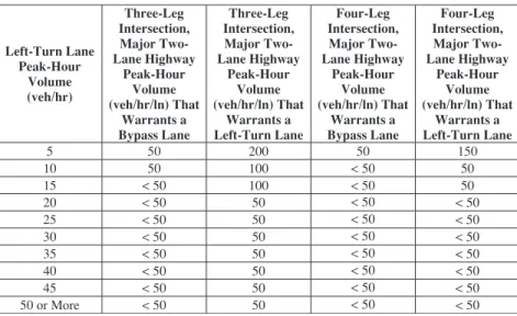
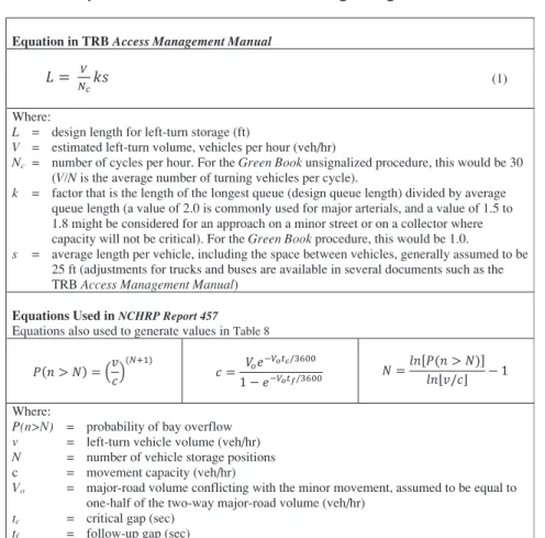
The TRB Access Management Manual (6) provides sug-gested storage length per vehicle for different percent truck levels (reproduced in Table 4).
Desirable and Minimum Lane Widths
Left-turn lanes at intersections and interchanges often help to facilitate traffic movements. Such added lanes should be as wide as the through-traffic lanes, but not less than 10 ft. Of course, the width of the turning lane is dependent on the
width of the median where it is located. If curbs are present, a curb offset of 1 to 2 ft from the edge of the travel lane to the face of the curb should be used (7). In urban situations with constrained space and low speed, 9-ft lanes have been used, but these are the exceptions rather than the rule.
Median widths of 20 ft or more are desirable at intersections with single median lanes, but widths of 16 to 18 ft permit rea-sonably adequate arrangements. Where two median lanes are used, a median width of at least 28 ft is desirable to permit the installation of two 12-ft lanes and a 4-ft separator. Although not equal in width to a normal traveled lane, a 10-ft lane with a 2-ft curbed separator or with traffic buttons or paint lines, or both, separating the median lane from the opposing through lane may be acceptable where speeds are low and the intersection is controlled by traffic signals. According to draft guidelines for accessible public rights-of-way published by the United States Access Board (8), a median width of at least 6 ft must be provided for storage where pedestrians will be present.
Tapers
Two distinct tapers are commonly defined in many guidelines: approach taper length and bay taper length. An approach taper provides space for a left-turn lane by moving traffic laterally to the right on a street or highway without a median. The bay taper length is a reversing curve along the left edge of the traveled way that directs traffic into the left-turn lane. Illustrations of the use of these tapers along with how the left-turn lane is added to the roadway are shown in the following figures:
• Figure 6 shows a left-turn lane added within a median.
• Figure 7 shows a left-turn lane that was added to an un-divided two-lane highway where the through lane on the
Figure 5. Typical left-turn lane layout.
Reaction
Time Deceleration Storage
Bay Taper
Table 4. Queue storage length per vehicle (6).
Trucks (Percent) Assumed Queue Storage Length (ft) per Vehicle in Queue
≤ 5 25
10 30
same approach as the added turn lane was shifted to the right the full width of the turn lane. This condition is known as a full-shadowed left-turn lane.
• Figure 8 shows a partially shadowed left-turn lane where both through lanes are shifted to provide the needed space for the turn lane. With partially shadowed left-turn lanes, the offset created by the approach taper does not entirely protect or “shadow” the turn lane (9).
• Figure 9 shows the condition when a lane is added to the outside edge of the approach, allowing through vehicles to pass left-turning vehicles on the right. This condition is also known as a bypass lane. The bypass lane minimizes delay to following through vehicles by allowing the vehicle following to pass the left-turning vehicle on the right, and then merge back into the through lane. Some states do not allow informal passing on the right or driving on the shoul-der; therefore, the additional width for through vehicles provides a legal means of passing slowed or stopped left-turning vehicles. Some agencies avoid this layout because of the mixed message to drivers between passing lanes and
this condition. For passing or truck climbing lanes, the newly added outside lane is for slower-moving traffic, and the inside existing lane is for faster-moving vehicles. For the configuration shown in Figure 9, the opposite situ-ation is present; the newly added outside lane is for the faster-moving traffic, and the inside existing lane is for the vehicles that are slowing and perhaps stopping while waiting to make the left turn.
Tapers for Left Turns (Bay Taper)
On high-speed highways it is common practice to use a bay taper rate that is between 8:1 and 15:1 (longitudinal:transverse [L:T]). Long tapers approximate the path drivers follow when entering a left-turn lane from a high-speed through lane. However, long tapers tend to entice some through drivers into the deceleration lane—especially when the taper is on a horizontal curve. Long tapers constrain the lateral movement of a driver desiring to enter the left-turn lanes. This problem primarily occurs on urban curbed roadways (5).
Figure 6. Left-turn lane within a median.
Bay Taper
Deceleration Storage
Figure 7. Full-shadowed left-turn lane.
Bay Taper
Deceleration Storage
For urbanized areas, short tapers appear to produce bet-ter visual “targets” for the approaching drivers and to give more positive identification to an added left-turn lane. Short tapers are preferred for deceleration lanes at urban intersec-tions because of slow speeds during peak periods. This results in a longer length of full-width pavement for the left-turn lane. This type of design may reduce the likelihood that entry into the left-turn lane may spill back into the through lane. Municipalities and urban counties are increasingly adopting the use of taper lengths such as 50 to 100 ft for a single-turn lane and 100 to 150 ft for a dual-turn lane for urban streets.
Some agencies permit the tapered section of deceleration left-turn lanes to be constructed in a “squared-off ” or “shad-owed” section at full paving width and depth, particularly in locations where a very short taper is applied. This configura-tion involves a painted delineaconfigura-tion of the taper. The abrupt squared-off beginning of deceleration exits offers improved driver commitment to the exit maneuver and also contributes to driver security because of the elimination of the unused portion of long tapers. The design involves transition of the outer or median shoulders around the squared-off beginning of the deceleration lane.
The Green Book provides advice regarding taper design. The recommended straight-line taper rate is 8:1 (L:T) for design speeds up to 30 mph and 15:1 (L:T) for design speeds of 50 mph. Straight-line tapers are particularly applicable where a paved shoulder is striped to delineate the left-turn lane. Short, straight-line tapers should not be used on curbed urban streets because of the probability of vehicles hitting the leading end of the taper with the resulting potential for a driver losing control. A short curve is desirable at either end of long tapers but may be omitted for ease of construction. Where curves are used at the ends, the tangent section should be about one-third to one-half of the total length.
Tapers for Through Traffic (Approach Taper)
Though left-turn lanes can be added in such a way that the merge taper guides turning vehicles into the turning lane, certain locations instead use the taper to guide through traffic to the right of the turning lane, as shown in Figure 7 and Figure 8. Such treatments are often used in rural con-ditions where it is beneficial to provide added protection and/or guidance to turning vehicles, particularly at isolated
Figure 8. Partially shadowed left-turn lane.
Bay Taper
Deceleration Storage
Approach Taper
Figure 9. Direct entry into left-turn lane (also known as bypass lane).
Transition Taper Transition
Taper
Note: Some agencies recommend against using this layout because drivers must change lanes to continue traveling straight; otherwise, the driver would be in the left-turn lane.