Transit-Oriented Development
Tools for Metropolitan Planning
Organizations
ABOUT THIS REPORT
Transit-Oriented Development Tools for Metropolitan Planning Organizations was written by Reconnecting America’s Center for Transit-Oriented Development. The Center for TOD is the only national nonprofit effort dedicated to providing best practices, research and tools to support market-based transit-oriented development. We partner with both the public and private market sectors to strategize about ways to encourage the development of high performing TOD projects around transit stations and to build transit systems that maximize the development potential. The Center for TOD is a partnership of the national nonprofit Reconnecting America, the Center for Neighborhood Technology, and Strategic Economics, an urban economics firm in Berkeley, CA.
ACKNOWLEDGEMENTS
The report was prepared by Annie Finkenbinder, Kelley Britt and Catherine Cox Blair of Reconnecting America and the Center for Transit-Oriented Development. The Center for Transit-Oriented Development would like to thank the Federal Transit Administration (FTA). The authors are also grateful to several persons who participated in a review of this report: Charlie Goodman, Kate Mattice, Jeff Price, Sharon Pugh and Joanne Waszczak, FTA; Robert Dunphy, Urban Land Institute; DeLania Hardy, AMPO, Chris Zeilinger, CTAA; Mariia Zimmer-man and Jeff Wood, Reconnecting America; and Effie Stallsmith.
NOTICE
This report was funded through a cooperative agreement between Reconnecting America and the Federal Transit Administration, U.S. Department of Transportation. The views and policies expressed
herein do not necessarily represent the views or policies of the Federal Transit Administra-tion. The United States government assumes no liability for the contents or use of this report.
Table of Contents
Introduction
What is Transit-Oriented Development? 5
What is a Metropolitan Planning Organization (MPO)? 8
Why MPOs + TOD? 9
FIGURE 1: SCALES OF TOD 10
TOD Requires Coordination of Many Institutions with Individual Goals 11
FIGURE 2: STAKEHOLDERS 12
Best Practices: Blueprint Planning 13
What Does Good Planning for TOD Require at the Regional Level? True Region-wide Planning 13
Best Practices: Corridor Planning 14
Best Practices: TOD Information Exchange 15
Bringing Disparate Constituencies Together – Consensus Building through the Planning Process 15
Best Practices: Create incentives for local jurisdictions to build at transit-appropriate densities 16
The Planning-Implementation Continuum Capacity Building 16
Best Practices: Innovative Funding Streams 17
Land Use Incentives 17
Access and infrastructure upgrades 17
Funding Challenges 18
Conclusions Appendix A -- Action List for Regional TOD Planning + Implementation Appendix B - Case Studies Denver Regional Council of Governments 22
Metropolitan Council - Twin Cities, MN Region 24
Sacramento Council of Governments -- Sacramento, CA 28
Appendix C - Tool Matrix 31
Introduction
What is Transit-Oriented Development?
Transit-oriented development (TOD) is an approach to development that leverages the unique opportunities provided by access to high-quality public transportation. Transit-oriented development contributes to attractive, walkable, sustainable communities providing residents housing and transportation choices that support an affordable lifestyle. TOD is typically defined as more compact development within easy walking or biking distance of a transit station, typically a half mile. At the core of transit-oriented development is the idea that people with a wide range of incomes can live and work in places with interconnected transportation networks that offer more transportation options, allowing them to take care of some of their daily trips using transit, walking and biking, rather than driving. Since the most transit supportive neighborhoods also tend to be compact neighborhoods, this density also supports a mix of uses and activities including housing, work places, child care, stores, and restaurants. And, because of this compact walkability and mix of uses, people can also take care of some of their daily needs by walking or biking to various destinations. Thus, people are able to reduce the amount of money spent on travel, the number of vehicle miles traveled by car, and perhaps the number of cars they own – with positive impacts not just for households but also for the general public.
To garner significant changes in behavior, however, alternative modes of transport must be convenient, timely, seamlessly connected, and safe. Increasingly,
practitioners are focusing on building transportation “networks”, rather than individual transit lines. These networks knit together a region’s vast array of neighborhoods, destinations and centers. A person might leave their home in the morning, walk to a nearby bus stop, catch a bus that connects to a light rail line, then ride into the city center where they walk the last few blocks to their office. At the end of the day, they might take a streetcar to a nearby restaurant, then bus home along an entirely different route. The regions that have attracted the greatest amount of development around transit facilities and made significant shifts in auto ownership and transit ridership are those regions that have highly interconnected transit networks, linked with safe and direct walking and bicycling networks. In these successful cases, TOD is not an isolated occurrence, but a network of places and nodes with community-wide and even regional scope.
TOD is a modern model based on old principles that provides solutions for building and strengthening our communities, addressing climate change, reducing our dependence on oil and providing more equitable access to economic opportunity for all Americans. The American public appears to be ready for change and practitioners across the country are ready to move from demonstration projects
to full scale implementation of the types of strategies that can simultaneously address local, regional, state, national and global needs.
A growing body of evidence supports the notion that if a substantial portion of America’s future development was located in compact, mixed-use, mixed-income walkable districts connected to regional destinations by high quality transportation networks – Transit-Oriented Development – a series of important current
challenges could be mitigated:
• Congestion Reduction + Increased Mobility Options The traditional goal of transportation planning is to ensure the efficient movement of people and goods throughout the region. TOD capitalizes on existing and proposed transit stations by creating walkable centers and neighborhoods that provide connections to regional employment and activity centers without having to drive. The presence of a regional transit network is key to TOD’s success as a congestion reduction tool.
− Residents of the most walkable areas of the country drive 26 percent fewer miles per day than those living in the most sprawling areas1.
• Increased Livability TOD creates neighborhoods— urban, suburban, and rural—with a variety of housing types affordable to all income levels
where people can live, work, and play. The average U.S. household
spends 34 percent of their annual budget on housing and 18 percent2 on
transportation. With coordinated housing and transportation planning that provides options beyond driving for commuting and everyday errands, that drops to a 9 percent share for transportation, freeing up household budgets for housing, savings, and education.
− The overall cost of living in a transit-rich communities would be lower since households would have the option of spending less on transportation. This would significantly benefit low- and moderate-income households who are most burdened by high travel costs2.
transportation options beyond single-occupant automobile travel opens up regional job opportunities to a wider pool of workers.
− Significant new, well-paying jobs could be created building transit and local transportation infrastructure, operating and maintaining transit service, and building and rebuilding homes and businesses near transit, A new generation of manufacturing jobs could also be generated to support increased bus and rail vehicle demand3.
− Businesses could be better positioned to retain employees as access to walkable urban environments has been noted as a key attractor for knowledge-talent4.
− Local governments could realize a “green dividend” from both the concentration of economic development in urban and suburban centers and from people spending money on local goods and services, rather than on gas and auto maintenance5.
• Improve Environmental Quality and Health Hundreds of regions and cities
throughout the country have established environmental quality as one of their primary planning goals, using both local revenue sources and federal funding like the Congestion Mitigation and Air Quality (CMAQ) program.
− A Center for Transit-Oriented Development study found that the Twin Cities region could fit roughly 60% of its forecasted new development of 24% of available land – meaning that using TOD principles to guide growth could reduce the amount of land consumed by 76%6.
− Transportation-related greenhouse gas emissions and traffic impacts of associated development would be lower as more households would have the option to not use their cars for daily commuting and other activities and car trips that are made are shorter in both duration and trip length7.
− Eliminating one vehicle and using public transit can reduce a two-car household’s carbon footprint between 25-30 percent8.
• Maximize the efficiency of transportation and real estate investments Creating
synergies between the public and private sectors creates and captures value. Value capture —where increases in property values generated because of new infrastructure like transit are used to cover some of the investment costs—can be seen as a strategy to recover part of the cost of new transit infrastructure or station area improvements. These improvemens can then serve as the basis for new TOD. TOD can also help to bolster value appreciation, which in turn can generate increased public revenues that can help lower the overall tax burden for residents and be used to fund community
investments.
− There is a growing demand for this type of development, so developers are willing to invest in TOD9.
− Compact development oriented around activity centers would become more desirable, as the types of amenities that currently make low density living attractive – parks, good schools, safe streets, affordable housing – are provided in location efficient places10.
• Generate sustainable transit ridership and farebox revenues Making transit accessible and convenient for a range of everyday activities along with the typical commuting trips increases both actual and projected ridership.
− Transit’s operating efficiencies could be increased as more people ride and steady sources of income are secured, including through joint development11.
• Support diverse neighborhoods Neighborhoods with a mix of ages, incomes,
household types, and ethnicities create a sense of place and community value. Using TOD strategies to increase the variety of available housing types that serve a range of households – from single person to large family – creates income diversity and bolsters transit use.
− 70% of 250,000 section 8/202 housing units within a half mile of fixed guideway transit will expire in 5 years12.
− 56.1% of tenants in privately owned subsidized housing (section 8/202 etc) are over 55 years of age13.
What is a Metropolitan Planning Organization (MPO)?
MPOs were mandated via federal legislation in 1973 for urbanized areas with populations greater than 50,000. Over time, the role of an MPO has evolved from single-purpose, programmatic agencies agencies charged with coordinating the transportation plans of their member jurisdictions to, after the passage of the 1991 Intermodal Surface Transportation Efficiency Act (ISTEA), active planning bodies responsible for producing long and short-range transportation plans, coordinating public participation in the transportation investment decision-making process, and serving as an impartial regional platform for debate and discussion. This work is all completed in conjunction with member jurisdictions via the MPO’s Policy Committee or member board. MPOs prepare both the long-range context and short-term priorities at the regional, policy, program, and project levels for spending federal surface transportation funds in metropolitan areas.
The responsibilities and strengths of Metropolitan Planning Organizations vary by regional size, political context, and state. In large metropolitan regions with extensive highway and transit networks like Denver, Atlanta or Dallas-Ft. Worth, the MPO has a director and a large professional staff who develop plans and policy, and perform analysis on transportation investment alternatives. In smaller regions, staff capacity may be more limited. Large regional governments with extensive staff capacity like counties or cities may serve as the MPO, with staff performing dual roles with municipal duties and supporting the MPO board. Other regions, like Minneapolis-St. Paul, have combined their transit agency with their MPO, a move that can improve planning efficiency and investment outcomes. The decision-making power of the MPO is dependent on the authority granted by both its member jurisdictions and the state government. While rural areas under 50,000 in population are not required to have MPOs, many have councils of government or rural planning bodies like Rural Planning Organizations (RPOs) that have the interest, mission and capacity to develop transportation plans and incorporate TOD strategies.
The structure of the MPO board, or Policy Committee, also varies by state and region. Generally, board members consist of officials from member jurisdictions, representatives of agencies like area transit providers or large freight operators, and state department of transportation officials. The Policy Committee votes to approve plans required by federal regulation—the 4-year fiscally constrained Transportation Improvement Plan and the 20-year Long-Range Transportation Plan (LRTP)—as well as other programs implemented by the MPO.
These disparate structures and contexts for MPOs can make it difficult to think in terms of prescriptive best practices for MPOs looking to become more involved in supporting successful transit-oriented development within their regions. MPOs are not granted governing authority under federal law, such as zoning or land use authority. In a few cases, MPOs have been charged under state laws with varying levels of authority, but those are very much the exception. Because planning area for an individual MPO is determined by the U.S. Census Urbanized Areas (UZAs), truly comprehensive regional planning that takes into account travel patterns and large regional economic engines can be difficult to accomplish in large areas like Northern New England, which has ten MPOs almost all within Boston’s commute shed.
Why MPOs + TOD?
Metropolitan Planning Organizations play a very important role in the planning and implementation of TOD. As regional planning bodies, MPOs are in a unique position to support stakeholders within their jurisdiction to take actions or adopt policies that support transit-oriented development and provide funding for planning and
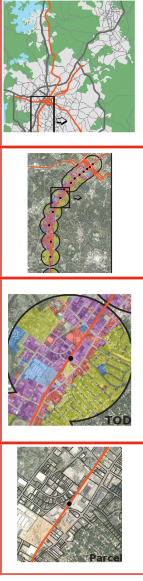
City or Region Scale
Multiple corridors in a city or region create a network of transit-oriented places and sites that integrate different functions and activity centers within easy access of transit. Planning at the regional scale can address problems such as connections to job centers and providing disadvantaged communities improved access to employment and retail opportunities. It is at this scale that overall mode shares and the health of a transit network can be most influenced. For example, the City and County of Denver, Colorado is thinking proactively about transit-oriented development opportunities around the 40 light rail stations that exist or will be built in the next 10 years. Denver staff are working to prioritize station-level planning processes, coordinate affordable housing and zoning policies, and engage with city residents about the opportunities presented by this major infrastructure investment initiative. The build-out of the regional FasTracks program, which will build five new rail lines in 15 years will transform the Denver region from an auto-oriented region into a region with improved mobility options that will shape regional growth for years to come.
Corridor Scale
The stations along a transit corridor support diverse and complementary transit-oriented
neighborhoods. As connections between adjacent station areas are strengthened through transit, the amenities and opportunities in one area are made more accessible to others. Effective, integrated corridor-level planning can encourage the momentum of market activity between station areas, thus augmenting and diversifying development and other opportunities. For instance, in the Fairmount/ Indigo Line Corridor, four community development corporations (CDCs) with contiguous boundaries have joined together to advocate for service upgrades and infill stations along an existing commuter rail corridor in Boston, Massachusetts. The CDCs are leading the advocacy for affordable housing and equitable development along the corridor, focusing on both housing and employment solutions, as well as local transportation improvements beyond the rail upgrades.
Station Area Scale
Planning for TOD at the station area scale should aim to ensure that the 1/2-mile radius around a transit node contains a mix of uses and supports transit access and ridership. Planning at this scale should take into account the existing neighborhoods, since there are no one-size-fits-all solutions to TOD. Some neighborhoods may have good opportunities to grow neighborhood buying power through high-density, mixed-use development, while other neighborhoods may have more potential to take advantage of transit through street and roadway improvements. MPOs can enter into joint development agreements with transit agencies and private entities to help fund station area improvements and access infrastructure. The Lake Pulaski Transit Village in Chicago, Illinois is an example of how incremental change has supported the emergence of a district-wide transit village in a low-income neighborhood on Chicago’s west side. Bethel New Life, a community development corporation, spearheaded efforts to revitalize the neighborhood. Affordable, energy-efficient housing in walking distance of the Pulaski/Lake El Station was the first stage of the village, followed by traffic calming and transit access efforts and a transit center adjacent to the station with a day care center, retail, an employment center, and a community technology center Site Scale
Individual buildings and developments turn the principles of transit-oriented development into physical reality. The design of streets and buildings can have a large impact on the types of transportation choices people make. When buildings are designed to take advantage of walking and transit, with active ground-floor uses and high-quality materials, they encourage increased walking, biking, and transit, and contribute to neighborhood vitality. When streets are designed to safely balance the needs of all users, it becomes easier for people to take care of their daily needs using transit. Public spaces, too, can provide important community gathering places and centers for activity. The Fruitvale Transit Village, in Oakland, California, is centered on a linear public space, connecting from the BART station to the main commercial street in the neighborhood. This connection is used by residents and transit riders alike, and provides an important connection tying the development in with the existing neighborhood.
FIGURE 1: SCALES OF TOD
One key to planning and building successful TOD is to recognize the importance of considering a range of scales. MPOs need to think about transit investments and TOD within all four geographic scales in order to have the most positive impact on regional goals like overall affordability and mobility.
transit supportive infrastructure. In long-standing federal law for MPOs, the goals of a typical regional TOD strategic plan dovetail with the goals that metropolitan planning organizations of all sizes must strive to meet with their planning efforts. TOD is more successful if both public and private investments are planned as part of a regional transit or TOD strategy. This improves the efficiency and the cost-effectiveness of transportation investments and yields more value to more people. Because MPOs play a primary role in identifying priority projects for federal transportation funding, they are uniquely set-up to support region-wide planning efforts, and to encourage local jurisdictions to implement TOD strategies when engaging in transportation, housing, or land use planning.
TOD Requires Coordination of Many Institutions with Individual Goals
While specific case studies that demonstrate how MPOs of different scales and contexts can play a role in regional TOD planning and implementation are discussed in the following section, there are some general ways in which all MPOs canconsider TOD, in strong, emerging, or even weak transit environments.
• Develop a “Plan for the Plan” In regions with little experience in planning
for transit and land use simultaneously, a plan detailing the strategy for community engagement and desired outcomes should be developed prior to undertaking a regional TOD planning effort. Key elements should include stakeholder interaction, and a methodology for considering transportation impacts on regional development patterns. Many regions and jurisdictions create growth management plans—TOD planning should both complement and inform that ongoing work.
• Define residential and employment/activity centers Some places, like Denver,
have developed a TOD Typology (FIGURE 3). The intent is not to define TOD narrowly but to lay out the complexities that must be addressed and simultaneously set boundaries for a range of choices so they are both manageable and recognizable. The goal is to define TOD in a way that is easily replicated but still has enough flexibility that it can respond to the different realities of different communities. MPOs can begin the transit-development planning process at the regional, corridor, and station levels through scenario planning—leading to identification of the most promising TOD market locations
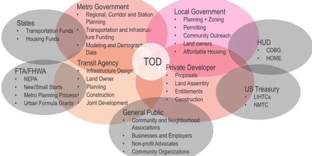
FIGURE 2: STAKEHOLDERS
• Local Agencies:Local planning, economic development, housing, and transportation staff are all stakeholders in TOD planning and implementation. Local agency staff and elected officials are critical in creating and adopting transit supportive, plans, policies and regulations.
• State Agencies: Although the role of state departments of transportation in TOD planning and implementation varies from state to state, the expenditure of state highway funds should be coordinated with transit planning and construction. State housing agencies can provide funds to support affordable housing projects at stations.
• Regional Agencies: MPOs and regional agencies provide technical and planning support, and allocate funding for transit supportive programs and infrastructure. Regional agencies also play an important role in convening the elected officials on issues of regional significance.
• Federal Agencies:FTA and FHWA oversee the planning and funding of corridors through the metropolitan planning and NEPA processes. DOT also provides grants, other funding and support for transit projects that can enable TOD.
• Transit Agencies: Transit agencies lead the planning, funding, construction, operation and maintenance of the transit system. They have to coordinate with many stakeholders throughout the planning and construction process to ensure high quality TOD is realized. Transit agencies adopt TOD supportive policies and own land around transit stations that is well positioned for joint development.
• Private Developers:A large responsibility for implementing transit-oriented development projects rests on market developers of housing, office, retail, and other uses. These real estate professionals have an important role not just in new construction, but also in the reinvestment in existing neighborhoods and structures.
• General Public: The general public—residents, workers, employers and community activists—all have a stake in seeing transit and TOD investments made wisely. If done right, all of the benefits and outcomes detailed above will accrue to this most basic group of stakeholders. Because transit-oriented development is a tool for neighborhood revitalization and investment, community-based organizations have a critical stake in both planning and implementing TOD.
Metro Government
• Regional, Corridor and Station Planning
• Transportation and Infrastruc-ture Funding
• Modeling and Demographic Data
TOD
Transit Agency • Infrastructure Design • Land Owner • Planning • Construction • Joint Development Private Developer • Proposals • Land Assembly • Entitlements • Construction Local Government • Planning + Zoning • Permitting • Community Outreach • Land owners • Affordable Housing US Treasury • LIHTCs • NMTC FTA/FHWA • NEPA • New/Small Starts • Metro Planning Process • Urban Formula GrantsStates
• Transportation Funds
• Housing Funds HUD
• CDBG • HOME
General Public
• Community and Neighborhood Associations
• Businesses and Employers • Non-profit Advocates • Community Organizations
• Provide technical capacity and staff assistance In some regions, MPOs
dedicate staff to support member jurisdictions with TOD planning and
implementation. They host events for information sharing and best practices on topics such as TOD zoning, parking challenges and affordable housing at transit stations.
• Allocate funds for TOD planning and implementation There are two types
of MPO funding that can be used to support TOD. Planning money can be used to support station area planning, market studies and implementation strategies for TOD. Project money that does not flow directly to the MPO can
also be programmed in concert with the State DOT and transit operators to support planning. Supportive funding for station area and corridor funding has been provided by some MPOs to local jurisdictions. In other instances MPOs have provided money to jurisdictions to construct transit supportive infrastructure such as local streets and pedestrian amenities.
What Does Good
Planning for TOD
Require at the Regional
Level?
True Region-wide Planning
MPOs are charged with providing regional-level coordination and planning for transportation investments. To maximize those investments with transit-oriented development, it is necessary for MPOs to also engage with their member jurisdictions in region-wide land use planning that is performed in conjunction with corridor and project analysis for transportation improvement plans (TIPs) and long-range transportation plans (LRTPs).Best Practices: Blueprint Planning
Over the past five years, over 80 cities and towns across the U.S. have engaged in visioning processes to chart a future for their communities. The blueprint planning process connects growth with transportation investments and the environment on a regional basis and looks at things like land use patterns, density, and urban form to find innovative solutions to challenges like housing, carbon emissions reductions, agriculture preservation, and regional economic development. See Appendix A for more information.
How do communities benefit from blueprint planning? • Provides a framework and process for
understanding the many complex issues that surround regional growth
• Builds regional consensus by giving communities the capacity and opportunity to actively
participate in the planning process
• Uses data tools and techniques to assess the impact of transportation and other public policy choices on a community
• Recognizes the impact of tradeoffs among achieving competing goals
• Helps in identifying and improves the
Some regions, like Salt Lake City, Utah and Charlottesville, Virginia, have done this though an integrated regional planning process based on growth scenarios that connect growth with transportation investments and the environment on a regional basis. Integrated scenario planning examines land use patterns, density, and urban form to find innovative solutions to challenges like housing, carbon emissions reductions, agriculture preservation, and regional economic development. FTA, FHWA, EPA, and other federal agencies support scenario planning and are actively promoting the use of blueprint planning by providing technical assistance, distributing information on scenario planning efforts nationwide, and facilitating peer workshops.
MPOs, no matter their structure, are challenged by working across state lines or nearby other Census Urbanized Areas where transportation and
Best Practices: Corridor Planning
Multiple corridors create a network of places and sites that integrate different functions and activity centers across an MPO’s jurisdiction. The districts along a corridor can support diverse and complementary mixed-income and transit-accessible neighborhoods, but require integrative planning across government entities to reach their potential as tools to promote affordability.
Transit corridors serve distinct functions within the regional network. Some corridors are focused on bringing commuters long distances into employment centers, while others are focused on more of the local connection and circulation functions. The corridor type will determine some of the opportunities with respect to transit-oriented development and the real estate market for housing and employment. Understanding the function of the transit corridor also helps in
decision-making about transit mode and service type. Transit corridors can change and evolve over time, but the initial investment in transit infrastructure needs to support the end goal for the corridor. CTOD has developed a transit corridor typology based on case studies from across the country (CTOD, 2007). The corridor types address the principal characteristics, including job centers, transit usage, land use, and population makeup. With this classification system, planning for both transit and land use can understand the potential for future outcomes based on initial transportation and development decisions. Suburb-to-suburb trips are a major part of commuting patterns in regions with decentralized job centers. Regions should identify the suburban commute corridors that do not necessarily directly connect with the region’s urban core. Jurisdictions within suburban commute corridors can create corridor plans that include the introduction of transportation options. Because these corridors usually developed in an auto-oriented fashion, transit investments need to be substantial and highly visible in order to provide a viable alternative to automobile use.
Some corridors will have existing activity patterns and densities that can effectively support transit ridership. Others will require multijurisdictional land use planning that uses corridor-wide zoning and incentives to direct both high-density job and housing growth to hubs along the corridor, creating transit nodes that increase connectivity between jobs and people. Any type of corridor will need cooperation amongst a variety of entities – including regional planning bodies, transit agencies, jurisdictions, community organizations, and individual stakeholders – to increase transportation affordability.
land development patterns cross political boundaries. To get the most benefits from TOD, the MPO needs to engage in multiregional planning to ensure TOD planning that enhances connectivity between regions, economic growth, and community development. This can involve other regional planning entities, transit agencies, MPOs, and state Departments of Transportation. The development of information-sharing protocols that make multiagency collaboration automatic and simultaneous with the planning process rather than an afterthought is a key step in this process.
Bringing Disparate Constituencies Together – Consensus Building through
the Planning Process
A diversity of people, interests, built environments, and political contexts can be found within one MPO region. Any TOD policy efforts by the MPO must be able to serve and respond to all of these populations effectively. Because of varied membership struc-ture and voting protocol, it is neces-sary that any planning, policy or pro-cess be collaborative from the start. A discussion about TOD involves more than just mobility—rather, it must ad-dress a region’s vision of how it wants to grow and live into the future. Some regions, like Salt Lake City, began their transit planning process with an exten-sive series of regional-level charrettes that brought together stakeholders and constituencies not traditionally as-sociated with transit planning, such as faith-based organizations and public health advocates.
Within the MPO context, the jurisdic-tions themselves are also stakeholder groups, and can range within one region from very urban employment centers to low density suburban com-munities. TOD is a scalable concept— meaning that new development should
Best Practices: TOD Information
Exchange
DRCOG created a TOD program in 2006 to provide relevant and timely information that helps policy makers, business leaders, and the public make informed decisions regarding TOD. Program activities have included the following:
• Online Resources—Website with an extensive compilation of resources including case studies, reports, interactive maps, station area plans and profiles, and information on development activity in current and planned transit station areas.
• Planner Idea Exchange—regular meetings for local government planning staff to share their experiences in planning for and implementing TOD and to learn from subject matter experts on topics of particular interest
• TOD Best Practices Series—workshops conducted in collaboration with the Urban Land Institute that bring together members of the public and private sector for panel discussions on timely topics
• Who is TOD?—original research on the residents and businesses located in current transit station areas and their perceptions regarding key issues related to land use and transportation planning
respond to different community contexts and serve every mode of transit, including commuter rail, bus rapid transit, and light rail. The Center for Transit-Oriented De-velopment has developed a typology for TOD that addresses these different scales and can be useful in creating a greater understanding of what both transit and transit-oriented development means for a region.
TOD is more successful if development and public transportation investments are planned as part of a regional transit or TOD strategy. This improves the efficiency and the cost-effectiveness of transportation investments and yields more value to more people. Because MPOs are the primary recipients of federal transportation funding on the regional and local level, they are uniquely set-up to support region-wide planning efforts, and to encourage local jurisdictions to implement TOD strat-egies when engaging in transportation, housing, or land use planning.
The Planning-Implementation Continuum
While specific case studies that demonstrate how MPOs of different scales and contexts can play a role in regional TOD planning and implementation are discussed in the following section, there are some general ways in which all MPOs can consider TOD, even with an emerging or weak existing transit network.
Capacity Building
Smaller MPOs often have municipalities with the least technical and financial
Best Practices: Create incentives for local jurisdictions to build at
transit-ap-propriate densities
Transit and affordable housing are two significant public investments. Some regions are tying the allocation of transit, infrastructure, and housing funds to agreements by local jurisdictions to deliver plans, zoning and other implementation tools that demonstrate a commitment to compact development at densities that can support existing or potential transit. A number of potential incentives exist that could be developed and implemented at various governmental levels. Portland Metro has two significant tools for place making and development that help with planning and implementation of TOD projects, the “Get Centered” program and the Transit-Oriented Development Program. The “Get Centered” Program provides tools to local jurisdictions to plan or envision walkable mixed-use neighborhoods that combine housing, employment, retail and is well-served by transit. The Transit-Oriented Development Program provides funding and uses public/private partnerships to enhance the economic feasibility of higher density mixed-use projects served by transit in key locations throughout the region. Some states also offer TOD incentives. In Massachusetts, specific state funds are provided for development in existing transit corridors. Density bonuses are a common tool used in communities to provide incentives to developers to improve the rate of return on development in exchange for locally determined benefits such as affordable housing, green space, historic preservation, and streetscape improvements. Local jurisdictions can reduce parking requirements for development near transit and can also provide developers an incentive to locate in a TOD.
capacity to further TOD planning and implementation at the neighborhood and site level. This underscores the importance of the MPO’s role in providing technical assistance to jurisdictions interested in TOD, but without the resources to develop a strategic plan or implementing policies. Information exchanges, planning grants that include funding and assistance to guide staff through the process of
plan-ning, policy development, and implementation in a way that fits individual community contexts as well as integrates into the larger regional TOD plan.
Land Use Incentives
While regional planning entities have no direct land use control, they can provide strong incentives for their member jurisdictions to coordinate their land use planning efforts with the regional plan, or for jurisdictions to create transit-oriented districts in conjunction with existing or proposed transit investments. Some regions include incentives for building or preserving affordable housing opportunities around transit. Several regions, including the Bay Area, Washington, DC, Minneapolis-St. Paul, and Atlanta, have created regional livable community funds with state and federal Surface Transportation Program (STP) and Congestion Mitigation and Air Quality (CMAQ) funds. These funds, generally distributed via a formula grant process, have helped local jurisdictions to update to local land use plans, preserve affordable housing, invest in station area infrastructure improvements, off-set the cost of higher density development, acquire key sites for TOD and support bicycling and walking activities. These pilot programs have been enormously popular and have incentivized significant changes in the way local governments have been able to respond to transit investments.
Access and infrastructure upgrades
Funding for access upgrades falls within the typical MPO role, but through a carefully designed project selection process MPOs can direct funding to projects that support a more livable transportation network that also supports long-term
Best Practices: Innovative Funding
Streams
The North Central Texas Council of Governments (NCTCOG) has instituted a tolling mechanism that could help with creatively financing transit development projects. The Regional Toll Revenue (RTR) funds are collected through the TollTag® system. This revenue stream is made up of two funds, one for new projects and the other for projects that are already in the pipeline. Although this program is used primarily for infrastructure improvements, with some creativity it can be directed towards future land use and/or transit projects. While NCTCOG does not have a specified program aimed at transit-oriented development, it does supply technical assistance and funding for transit planning and corridor studies to local jurisdictions. These plans can be integrated into the Regional Transit Initiative and then could be used to spur future TOD development projects.
TOD opportunities and good land use outcomes.
Funding Challenges
Generally, federal funding through FTA’s formula-based programs (Section 5307) is very predictable and, for areas with less than 200,000 people, required to be spent in specific urbanized areas of the state. Generating predictable funding for transportation and transit-oriented development from non-federal sources is difficult because: (1) a portion of funding is dependent on congressional appropriations process,and (2) state funding is not always a consistent stream. MPOs need to be creative and flexible with other revenue sources to fund TOD planning and implementation.
MPOs should also be aware of the possibilities within flexing Federal Highway Administration (FHWA) funding to pay for transit and transit-related projects. STP and CMAQ, along with smaller programs like Transportation Enhancements, can be programmed to pay for transit investments, including access infrastructure.
Conclusions
MPOs have a key role to play in regional planning for transit-oriented development. While other regional planning entities, including transit agencies and non-MPO regional planning councils, have prominent seats at the table during the TOD planning and implementation processes, MPOs are in the best position to
coordinate and lead these efforts because of their policy-making authority, regional coordinating role, and access to federal funding.
This natural positioning as leaders in thinking about regional TOD requires MPOs to consider a variety of planning tools, creative funding mechanisms and other ways they can assist their member jurisdictions in connecting land use and transportation infrastructure investments. MPO staff and leadership can play a critical role in leading the regional planning process while ensuring that each member jurisdiction’s unique needs are met.
Appendix A -- Action List for Regional TOD Planning +
Implementation
MPOs should approach TOD planning as a convening process for their member jurisdictions, other regional planning and transportation agencies, state and federal stakeholders and the private and nonprofit sector,.
Educate MPO Board Members on Transit-Oriented Development and its Benefits The biggest challenge to creating programs and policies that encourage TOD is often a lack of understanding amongst political leaders of how transit-oriented development can benefit their communities. Seminars and workshops addressing what TOD is can provide an opportunity to brainstorm about the most appropriate tools to encourage TOD within the MPO region.
Develop Public Involvement Strategy
Region-wide planning for transit-oriented development—whether in conjunction with planned transit or an already existing network—requires a high level of community involvement. During the in-depth blueprint planning processes in Sacramento and Salt Lake City, the MPO partnered with area nonprofit organizations to ensure civic engagement and public input in the decision-making process. Key to almost all public engagement strategies for both region-wide TOD planning and smaller-scale multi-jurisdictional efforts like corridor planning, is the charrette process. Charrettes allow citizens and policymakers to visualize and have input on different choices about key TOD elements like density, land use patterns, and station access.
Think About a Regional Typology for Station Areas
Typologies provide a way to think about how TOD works in different contexts – from the urban downtown to the low-density suburban – and help citizens and policymakers understand how their individual community fits into a larger regional plan about TOD and transit. A typology framework created with public input helps member jurisdictions simplify the complex decisions that surround planning for TOD projects and station areas by providing details about the scales of development likely to occur in different places. It also provides a context for the larger transit network, including possible future investments by thinking strategically about connections to regional employment centers, entertainment destinations, and how transit riders are likely to use the system
Along with the stakeholders described in Figure 2, MPOs should use the typology as a framework for identifying residential neighborhoods, employment clusters, and
the primary corridors that serve the region. Full engagement with all jurisdictions through this process is essential to reach agreement on where new development will take place, how dense it will be, and where concentrations of activities will be located. The following are examples of typologies developed for regions, and for individual cities:
− Austin, Texas - http://www.ci.austin.tx.us/planning/tod/downloads/ Ch2_LUTypes_StreetX.pdf
− CTOD’s Station Area Planning 202 - http://www.reconnectingamerica. org/public/show/tod202
− Denver, Colorado - http://www.denvergov.org/TOD/StationTypology/ tabid/395260/Default.aspx
Fund TOD studies through the Unified Planning Work Program
MPOs can take advantage of funding that is provided to metropolitan and state agencies for the development of TOD and TOD related plans, programs, and
supporting analyses. MPOs document their planned use of these funds in Unified Planning Work Programs (UPWPs). Station area plans, market studies, station access studies, technical assistance programs, corridor analysis and developing regional typologies fall under the UPWP. The North Central Texas Council of Governments (NCTCOG) includes TOD education events, implementation action plans, market analysis and visioning charrettes in the NCTCOG UPWP.
− http://www.nctcog.org/trans/sustdev/landuse/funding/tod.asp Identify Key Corridors for TOD
Transit corridors serve distinct functions within the regional network, and involve multiple jurisdictions, usually on a smaller scale than a full regional planning exercise. For TOD corridor planning processes, MPOs are well-positioned to serve as the convener of these multiple jurisdictions. Stakeholders often have different ideas regarding the best and highest use of a major transportation corridor. TOD corridor planning can set the stage for future transit investment, helping to ensure high ridership numbers because of the transit-supportive land uses already in place.
Consider Regional Affordability Goals that Combine Household Housing and Transportation Expenses
Transit-oriented development can be used as a strategy to reduce overall household expenses, particularly for working and low-income families. Living near public transportation, whether fixed guideway or bus, allows families to cut
down transportation costs by means such as owning only one car, consuming less fuel, and foregoing parking expenses. Housing affordability goals are developed by the regional Public Housing Authority (PHA) in the form of the HUD-required consolidated housing plan process. Linking regional transportation and housing affordability goals can be done in the form of a large-scale blueprint planning process, or by coordinating the planning processes between the MPO and PHA to ensure that affordable housing near transit is created or preserved.
Identify Funding Sources for TOD Activities
Because MPOs generally receive funding from a variety of sources – ranging from a regional sales tax in the Twin Cities to funding allocated directly from the US
Department of Transportation – they have some flexibility in how money can be spent. In California, the Bay Area’s MPO uses a combination of funding from the federal CMAQ and STP programs to fund its Transit for Livable Communities (TLC) grants. Many regions are now thinking about using HOT lanes and other forms of congestion pricing to fund innovative transportation projects.
Link Funding for Transportation Infrastructure Improvements to Locally Adopted Transit-Supportive Land Use Measures
MPOs that have successfully engaged in a regional TOD planning process can link funding for station access improvements and other transportation/TOD infrastructure investments like pedestrian facilities or new transit, ensuring that improvements made with regional funding will be supported by local decisions. This should be done in conjunction with either a regional planning effort or capacity-building for TOD planning within member jurisdictions.
Build Capacity for TOD Planning and Implementation Within Member Jurisdictions Even without region-wide support for transit-oriented development, MPOs can
assist member jurisdictions interested in maximizing the benefits of transit through TOD. Capacity building can take the form of a number of different policy tools and programs, including:
− Provide direct technical support in TOD planning.
− Grant programs like MTC’s Transit for Livable Communities or the Washington Area Council of Government’s Transportation/Land Use Connections program that provide support for community planning activities and small-scale infrastructure improvements.
− In the Twin Cities, the Metropolitan Council’s Livable Communities grant program provides funding for TOD infrastructure as well as gap financing for affordable housing.
Appendix B - Case Studies
Denver Regional Council of Governments
MPO Context:The Denver Regional Council of Governments (DRCOG) is a regional organization that serves 2.8 million residents in the Denver metropolitan area. Created in the midst of the 1950s post-war growth boom, DRCOG continues its founding philosophy today by bringing more than 50 city and county governments together to work on common issues that affect the region’s future. Each member city and county is entitled to have one of its elected officials serve as a
representative to the DRCOG Board of Directors. DRCOG’s program areas include regional growth and development planning, transportation planning, traffic operations, travel demand management, transit-oriented development, environmental issues, shared government services, aging services, data and maps.
− www.drcog.org
Current transportation network context
The Denver region’s current transit system includes 35 miles of light rail serving downtown and the southern portion of the metro area, as well as more than 140 local, express and regional bus routes. In 2004, voters in the Denver region approved a tax increase to pay for FasTracks, a $4.7 billion program to expand the transit system. The largest transit expansion in the country, FasTracks includes 122 miles of new light rail, 18 miles of new bus rapid transit service and 57 new transit stations. According to the most recent analysis, the estimated cost of the program has increased to $6.9 billion, creating a $2.2 billion funding shortfall. The region is currently considering various options for addressing this shortfall, including seeking another tax increase or extending the program beyond the originally scheduled completion date of 2017.
Goals in implementing regional TOD policy:
DRCOG’s Metro Vision Plan addresses the long-range transportation, land use and the environmental needs of the region, and embodies the local governments’ collective vision for the future. The plan encourages the development of higher-density, mixed-use, transit- and pedestrian-friendly urban centers throughout the Denver region, and calls for a significant portion of future regional growth to occur in these centers. According to this vision, urban centers will be served by transit and also will support transit by increasing ridership and creating pedestrian-oriented environments.
− www.drcog.org/MetroVision Tool/Policy:
DRCOG created a TOD program in 2006 to provide relevant and timely information that helps policy makers, business leaders, and the public make informed
decisions regarding TOD. Program activities have included the following:
Web site with an extensive compilation of resources including case studies, reports, interactive maps, station area plans and profiles, and information on development activity in current and planned transit station areas.
− Planner Idea Exchange – regular meetings for local government planning staff to share their experiences in planning for and implementing TOD and to learn from subject matter experts on topics of particular interest
− TOD Best Practices Series – workshops conducted in collaboration with the Urban Land Institute that bring together members of the public and private sector for panel discussions on timely topics
− Who is TOD? – original research on the residents and businesses located in current transit station areas and their perceptions regarding key issues related to land use and transportation planning
Metropolitan Council - Twin Cities, MN Region
MPO ContextThe Metropolitan Council, or Met Council, was established by the State of Minnesota in 1967—in advance of federal legislation requiring regional transportation planning
entities for urbanized areas of certain populations. There are 17 members, all appointed by the Governor and confirmed by the Minnesota state senate, who represent 16 distinct districts with one at-large member. The Council manages regional wastewater
in addition to serving as the Metropolitan Planning Organization (MPO), and providing bus and fixed guideway transit service throughout the region through its operating arm, Metro Transit. It is funded primarily via state appropriations of state funding and federal funding. The region also has another transit funding entity, the Counties Transit Improvement Board (CTIB), that receives funding from a regional sales tax levy approved by the state legislature in 2008.
The region’s diverse context requires the Met Council to serve urban, suburban, and more rural communities simultaneously. They also work with large cities and counties like the City of St. Paul and Hennepin County when planning for transit investment and TOD along with jurisdictions with less financial and professional capacity for large-scale housing or community planning programs.
Current transportation network context:
The first light rail corrior in the region, the Hiawatha line, opened in 2004
connecting downtown Minneapolis and the Minneapolis-Saint Paul airport within a north-south corridor. 20-year ridership projections made during the planning process were met within the corridor’s first year of operation, The Met Council is pursuing an aggressive expansion of the regional light rail network that includes planned cross-region corridors connecting the centers of Minneapolis and St. Paul, and light rail and commuter rail extending far into the suburbs. This will provide
transportation options to areas previously only served by infrequent bus service.
Goals in implementing regional TOD policy:
The Livable Communities Grant program, introduced in as a Twin Cities-specific state-level policy in 1995, is not explicitly a program encouraging transit-oriented development, but shares objectives with TOD and can be used for TOD planning and implementation. The Twin Cities were once served by an extensive streetcar network, so some closer-in neighborhoods were already primed for the
re-introduction of fixed guideway transit, but there was a greater regional disconnect between land use and infrastructure investment. The program is meant to provide funding avenues for communities and jurisdictions to connect development patterns with access to jobs and services.
Tool/Policy:
The Livable Communities
Program houses three separate grant programs administered by the Met Council – the Livable Communities Demonstration Account, the Local Housing Incentive Account, and the Tax Base Revitalization Account. When initially enacted by the state legislature, it was meant to assist communities in the Twin Cities region with carrying out their affordable housing plans, as well as providing a strong incentive for producing jurisdiction-wide housing plans that addressed affordability needs. It is funded at $8 million per year through state funding. There is also a land-acquisition fund for transit-oriented development in its nascent stages associated with this program. STATED PURPOSE:
“LCDA funding will support projects that demonstrate innovative ways of meeting Framework goals and strategies to achieve connected, efficient land-use patterns in communities throughout the region.
− Develop land uses in centers linked to the local and regional transportation systems.
− Efficiently connect housing, jobs, retail centers and civic uses.
− Develop a range of housing densities, types and costs.
development that is sensitive to the environment.”
A volunteer Livable Communities Advisory Committee composed of a broad cross-section of stakeholders, including community members, local agency staff, architects, and policymakers, is charged with evaluating proposals and recommending funding awards.
Projects are rated on several criteria, including land use and planning process criteria, innovation or demonstration, funding as a catalyst, and project readiness. The program is an intended as an incentive to encourage local jurisdictions to participate in the Met Council’s regional affordable housing allocation process. Affordable housing is one criterion, but not a requirement. The Met Council is in the process of creating a bonus for transit proximity.
Several other regions, including Portland, Oregon and San Francisco, CA, have created regional livable community funds. These funds have fostered updates to local land use plans, preserve affordable housing, invest in station area infrastructure improvements, off-set the cost of higher density development, acquire key sites for TOD and support bicycling and walking activities. These pilot programs have been enormously popular and have incentivized significant changes in the way local governments have been able to respond to transit investments.
Program Development and Centers Metro Transit Oriented (Portland, OR)
Met Council Livable Communities Demonstration Account (Twin
Cities, MN) NCTCOG Sustainable Development Landbanking Program (Dallas-Fort Worth, TX) Overview
Grant program available to developers for construction of projects, coupled with long-term easements to ensure compliance.
Grant program to local jurisdiction for development. Originally included both planning and capital grants. Planning grants eliminated several years ago.
No-interest loan program for landbanking only. The Sustainable Development Funding Program also includes funds for pedestrian, bicycle, and transit improvements and planning.
Objective Create demonstration projects that exemplify the region’s goal to “grow up, not out.”
Support for demonstration projects to achieve “connected, efficient land-use patterns in communities throughout the region.”
Encourage public/private partnerships that positively address existing transportation system capacity, rail access, air quality concerns, and/or mixed land uses.
Program Funding Source and Level
Metropolitan Transportation Improvement Program (MTIP) Regional Flexible Funds exchanged with local funds. Other funding sources to date have included CMAQ, direct FTA funds and earmarks, local government funds and interest earned. Funding is currently $4 million/year.
The LCDA funds come from the Metropolitan Council’s regional tax levy, which the Council must renew each year. Funding is currently $8 million/year
Funds for the program come from local infrastructure funds “swapped” for Federal CMAQ and Surface Transportation Program Metropolitan Mobility funds, but will come from toll revenue through the North Texas Toll Authority in the
future. There may be some restrictions on the use of toll revenues that limit flexibility, but the funding will be easier to disburse due to fewer contracting restrictions. Landbanking restricted to no more than $8.1 million (20% of total funding pool of $40.6 million program)
Program Development and Centers Metro Transit Oriented (Portland, OR)
Met Council Livable Communities Demonstration Account (Twin
Cities, MN) NCTCOG Sustainable Development Landbanking Program (Dallas-Fort Worth, TX) Typical Project Funding Level
Approx. $300K. per grant. Grant funds do not require funding recovery.
No cap on funds to individual projects, but max. grant has been $2.5 million.
Grant funds do not require funding recovery. Projects can ask for funding in multiple years. A cap of 40% of the funds can go to grants in Minneapolis and St. Paul.
Projects awarded up to $1 million each Awards require repayment of principal. Cities keep profit (or pay loss, in that event).
Program Strengths
• Simple process makes funding attractive to developers.
• Wide political support for program and Metro is looking toexpand scale of program.
• Funding is flexible and has beenpopular and competitive.
• Funding is an incentive to reach other regional goals (allocation of affordable housing).
• Advisory Committee structure useful.
• Provides funding for land acquisition while allowing cities to benefit from profitable ventures.
• Requires 20% minimum local match.
Program Weaknesses
• Not enough funding; would be more effective to be able to fund at higher levels.
• Individual projects have had limited impact on surrounding areas and have not leveraged substantial additional development.
• LCDA does not target specificgeographic areas, so impact of funding is diffuse.
• Funding requests vastly outstrip program resources
• City/NCTCOG/Developer relationship difficult for staff to manage.
• Does not place conditions on use of profits from fund use (i.e. proceeds must be use for mixed-income housing)
• Staff feels program has not been successful, and will not recommend a next round of funding.
Sacramento Council of Governments -- Sacramento, CA
MPO ContextIn California, MPOs receive direct allocation of federal funds via formula, giving them autonomy and a predictable source of federal funding to undertake projects of regional significance, and to distribute funds to their member jurisdictions. Board members of the Sacramento Area Council of Governments (SACOG) are appointed by their home jurisdictions, and must be either a Mayor or a member of a City Council. Sacramento County and the
City of Sacramento – the population center of the region – are entitled to two voting members, while other jurisdictions may appoint one each. Member jurisdictions use a Joint Powers Agreement (JPA) to give the SACOG-adopted plans and policies legal standings.
Current transportation network context:
Sacramento’s transit network, which is run by the Sacramento Regional Transit Authority, has seen huge expansion in the past decade. In 2003, the first light rail line opened connecting parts of north and south Sacramento to downtown. The second line, an east-west route, opened in 2005. RTA also operates an extensive regional bus system. There are long-term plans to extend light rail further into the region as funding becomes available.
Goals in implementing regional TOD policy:
As rapidly growing region that wanted to plan strategically for both population growth and open land preservation and anticipated difficulty meeting current and future state and federal environmental benchmarks, Sacramento needed to plan in a way that looked at all regional systems and potential decisions holistically and systematically.
The Blueprint Planning process does not explicitly plan for transit-oriented
development, but rather sets the stage for making concrete connections between land use, infrastructure investment, and desired outcomes like affordability, cleaner air, and open space preservation.
Tool/Policy:
The Sacramento Blueprint is the product of a three-year public involvement effort and partnership between the regional Council of Governments (SACOG) and a
Sacramento Blueprint visualization
local non-profit, Valley Vision. Over 35 public workshops were held, and over 5,000 people used the project’s interactive technology to consider the best land use scenario for the region.
The Preferred Blueprint Scenario, approved in 2006, uses performance measures based on smart growth principles like offering a variety of housing types for
different households and income levels, natural resource stewardship, and compact development. The plan is part of SACOG’s transportation plan, and will be the
framework to guide local governments in growth and transportation planning through 2050.
For smaller regions or regions that don’t have the financial capacity to undertake a large-scale planning process that uses visualization technology, a first step could be to begin coordinating the MPO’s long-range transportation planning with the region’s Public Housing Authority’s HUD-required consolidated housing plans. This begins the process of linking housing and the built environment with transportation investments, and leverages multiple federal funding silos that could go on to spur private investment and TOD in existing and proposed transit zones.
What is the Blueprint Planning Process?
− Identify performance goals for the region, based on the major forces of change like planned transportation investments, population growth, and land development.
Example: Goals could include measures like reducing carbon emissions by 20 percent, preserving regional open space, or providing a certain number of work-force housing units by the target date.
− Create a set of scenarios that look at how the adoption of different sets of policies and investments will affect regional quality-of-life, including environmental impacts, affordability, water quality, public infrastructure expenditures, and congestion. Usually a “baseline” scenario is created to show the effect of continuing with business-as-usual development patterns and transportation investments.
Example: How do more compact residential development patterns affect a re-gion’s average commuting distance?
− Analyze the implications of different scenarios using visualization tools like geographic-information systems mapping (GIS). Mapping the quantitative data produced by the different scenarios helps the public
and decision-makers understand the potential impacts.
Example: Does a new Bus Rapid Transit corridor have a more positive impact on agricultural land preservation than expansion of an existing highway?
− Provide the public, decision-makers, and city planners with opportunities to evaluate each scenario by comparing indicators relating to land use, transportation, demographics, environment, economics, technology, and other driving forces.
Example: One scenario might meet climate targets but falls short in economic benefits, or vice versa
− Monitor progress. Blueprint planning is an ongoing process, and real growth patterns need to be compared with which set of policies and investments are selected to ensure performance goals are met.
TOOLS SCALE GOALS EXAMPLES
Regionwide Jurisdictional Consensus-Building EducationTOD ImplementationTOD
Planning Tools
Start a Regionwide Strategic
Planning Process X X X X
Salt Lake City, UT (http://www. envisionutah.org/); Sacramento (http://www.sacramentoblueprint. org); Charlottesville, VA(http:// www.tjpdc.org/community/epi.asp) Identify Appropriate TOD Typology X X X Denver, CO (http://www.denvergov.org/)
Engage in Corridor Planning X X X X X
Charlotte, NC; St. Paul, MN (http://www.metrocouncil. org/transportation/ccorridor/ centralcorridor.htm)
“Carrot” Tools
Link Transit-Appropriate Land Use to Funding Eligibility for Transportation
Funds X X
San Francisco Bay Area (http:// www.mtc.ca.gov/)
Create incentives for TOD supportive
zoning and land use X X
State of Massachusetts (http:// www.mass.gov/envir/smart_ growth_toolkit/pages/mod-40R. html)
Provide planning funds for linking
land use and transportation X X X X
Washington, DC (http://www. mwcog.org/transportation/ activities/tlc/); SF Bay Area; Twin Cities, MN (www.metrocouncil. org/services/livcomm.htm)
Funding Tools
Think Innovatively about Funding
Sources X X X Dallas, TX
Provide funding for infrastructure
upgrades X X
SF Bay Area; Portland, OR (http://www.oregonmetro. gov); Atlanta (http://www. atlantaregional.com/) Create Tax Increment Finance
Districts (TIFs) or Benefit Districts X X Dallas Office of Economic Development
Capacity-Building Tools
Develop Board member training
program X X Albany, NY
Direct Technical Assistance to
TOOLS SCALE GOALS EXAMPLES
Regionwide Jurisdictional Consensus-Building EducationTOD ImplementationTOD
Planning Tools
Start a Regionwide Strategic
Planning Process X X X X
Salt Lake City, UT (http://www. envisionutah.org/); Sacramento (http://www.sacramentoblueprint. org); Charlottesville, VA(http:// www.tjpdc.org/community/epi.asp) Identify Appropriate TOD Typology X X X Denver, CO (http://www.denvergov.org/)
Engage in Corridor Planning X X X X X
Charlotte, NC; St. Paul, MN (http://www.metrocouncil. org/transportation/ccorridor/ centralcorridor.htm)
“Carrot” Tools
Link Transit-Appropriate Land Use to Funding Eligibility for Transportation
Funds X X
San Francisco Bay Area (http:// www.mtc.ca.gov/)