Ivin Amri Musliman 1 , Alias Abdul Rahman 1 and Volker Coors 2
1
Dept. of Geoinformatics, Faculty of Geoinformation Science & Engineer-ing, Universiti Teknologi Malaysia, 81310 Skudai, Johor, Malaysia. [email protected], [email protected]
2
Faculty of Geomatics, Computer Science and Mathematics, Hochschule für Technik, Schellingstr.24, 70174 Stuttgart, Germany.
Abstract
street, etc). And as for implementation, a GUI provides the users with means (e.g. fill-out forms) to specify SQL queries interact and visualize 3D outcomes in virtual reality environment. This has opened up the ability to distribute and navigate accurately in 3D virtual worlds. The initial study on Klang Valley will go through data conversion processes from different formats like Laser, VRML, CAD and Shape 3D in a first person view envi-ronment using a developed system using VRML, JAVA and .Net compiler. The dataset structure will be in the form of various 2D, 2.5D and 3D array of height fields.
KEY WORDS: 3D-GIS, Navigation, Visualization, Virtual Reality.
1. INTRODUCTION
The needs for three-dimensional (3D) visualization and navigation within 3D-GIS environment are growing and expanding rapidly in a variety of fields. This requires a number of specific issues to be investigated, e.g. 3D routing accuracy, appropriate means to visualize 3D spatial analysis, tools to effortlessly explore and navigate through large models in real time, with the correct texture and geometry.
There are many promising applications in reach, if we can take advan-tage of the “knowledge” of third dimension in the applications. For exam-ple, in 3D navigation, one can have an accurate point-to-point network routing based on 3D network model compared to 2D if an accurate data set is present. Besides that, it can also used to determine the position and the orientation of a human within an urban environment, for instance (Jasnoch et al, 2000). A virtual tourist can use this information to get from one place of interest to another with an accurate and efficient route and retrieve de-tailed information of that particular place, thus taking advantage in travel planning.
The overall aim of the study is to investigate on the support of naviga-tion in real world environment. This will include; firstly, a research on the benefits of using 3D network model (non-planar graph) compared to 2D which will not limited to buildings but also at street level. Secondly, em-phasis on how to use and generate visual landmarks for route descriptions. For implementation stage, a GUI will be developed which provides the us-ers with means (e.g. fill-out forms) to specify SQL queries, interact and visualize 3D outcomes in near-virtual reality environment (PC based).
This paper describes the possible research for 3D navigation develop-ment as one of 3D-GIS application. Firstly, a simple concept on 3D navi-gation for 3D-GIS is briefly presented. Several research questions have been point out here as well. Secondly, it concentrates on the methodology for the development of a simple viewing prototype of the 3D navigation solution. A short description for the experiment is described. Final remarks and further works summarize and conclude the research on 3D navigation for 3D-GIS.
2. 3D-GIS
2.1 3D Navigation
Van Driel (1989) recognized that the advantage of 3D lies in the way we see the information. It is estimated that 50 percent of the brain's neurons are involved in vision. What's more, it is believed that 3D displays stimu-late more neurons: involving a larger portion of the brain in the problem solving process. With 2D contour maps, for example, the mind must first build a conceptual model of the relief before any analysis can be made. Considering the cartographic complexity of some terrain, this can be a dif-ficult task for even the most dexterous mind. 3D display, however, simu-lates spatial reality, thus allowing the viewer to more quickly recognize and understand changes in elevation and texture.
2.2 The Research Questions
In order to be able to start investigating 3D navigation techniques and so-lutions for 3D-GIS, the present system (techniques and soso-lutions) had first to be thoroughly examined and described. In this research, although with the support of visual landmarks in navigation, several research ideas and possible methods still remain as gaps that need to be addressed, where the following research questions raised:
• How to generate visual landmarks descriptions as a solution for 3D navigation? How do visual landmarks influence a 3D visualization as navigation support?
• What is the most suitable or appropriate spatial modeling for 3D navi-gation 3D-GIS environment? Will mobile augmented or mixed-reality visualization make a big benefit towards 3D navigation?
For data accuracy wise, to have an accurate routing (in buildings, or in narrow street, etc), 3D geometry and surface obtained from Laser and any related data will be used. Emphasis is put on how OGC stan-dards could be implemented in such system, especially uncertainties about their integration between several data formats and systems that will be handled in 3D navigation solution. Possible methods of 3D-GIS database regeneration and integration by reconstructing 3D buildings will, as mentioned above, be one of the main issues to be discussed in this study. Here, focus will be on processes rather than on technical device.
• Does generalizing roof top in large-scale maps will affect the accu-racy of the generated 3D-GIS database?
Generalization of 3D objects plays a major role in 3D navigation. It is possible to use either Level-of-Details (LoD) or some compression (e.g. Edgebreaker, Delphi, etc.) or even multi-resolution modeling approach to improve data storage and retrieval in order to avoid the time-consuming data rendering and query results.
• Will the implementation of data compression to the generated 3D-GIS database improve data retrieval or the use of LoD would be better? How about tiled-based method (Zhu et al., 2002)? Or trying to imple-ment using multi-resolution modeling (Coors & Flick, 1998)?
of these multi-resolution modeling approaches is focused on redun-dancy free transmission of different LoD on demand in a web-based application.
• How to implement multi-resolution modeling in 3D navigation solu-tion without having transmission redundancy of different LoD?
3. METHODOLOGY
The exploration of the 3D worlds in the near-VR systems ensures a certain level of virtual reality techniques. Existing VRML, X3D, JAVA, GML, SVG and other Web standards and software modules allow the develop-ment of GUI with limited effort, relying on some operations provided by browsers or viewers. Therefore VRML and JAVA will be employed as a front-end engine to the 3D-GIS model.
As for a start, a simple viewing prototype has been developed. The pro-totype tries to render and visualize the 3D city model of Putrajaya and try to connect the objects in the 3D scene with their attributes in the land reg-istry dataset. Laser data of Putrajaya area obtained from the National sur-vey department is used. The true distance for accurate routing will be based on surface model from Laser data. The motivation was to give the user the ability to interact with the 3D scene not only by moving around, but also to have access to the attributes information by clicking on the ob-jects or ‘intelligently’ display the information on the screen. The given 3D dataset only consists of geometry information so that an algorithm had to be invented, which connects the geometry with the attributes.
This section is considered to be the designing and developing a simple viewing prototype of 3D navigation solution. The simple application pro-totype is just an initial progress of the full development to show how 3D navigation for 3D-GIS can be done. Although the test application is a desktop application, it is possible to realize the concept on a website as well. The VRML viewer can be added in web pages and the application part could be realized as a Java Applet, which interacts with the viewer.
3.1 Tools
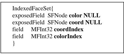
IndexedFaceSet{
exposedField SFNode color NULL exposedField SFNode coord NULL field MFInt32 coordIndex field MFInt32 colorIndex }
Fig. 1. Part of VRML Specification ’97
Viewer be added into the .Net projects as an ActiveX component. There are also some event handler classes to handle mouse events and other in-terface functions so you can completely interact with the viewer.
3.2 Visualization
The 3D geometry dataset will consists of several ASCII files (temporary) dumped or connected directly form databases, which will consist of point tables. Besides the x, y, z-coordinates each point has got the attributes hou-seindex, wallindex, kindofwall (roof, wall, floor). With the help of these attributes it is possible to create an IndexedFaceSet-Node (IFS). The used fields are shown in Figure 1. This VRML-Node seems to be the best solu-tion to describe the building geometry, because it can describe complex objects, which consist of several areas, very easily.
Converting the ASCII information (temporary) into VRML syntax will go through the ASCII table first, read the coordinates and the attributes and then decide when to create a new building (IFS-Node), a new area or when to change the color of the created area to color roof and walls differently based on the attribute selected.
3.3 Connection to attribute data
The connection is done by a geometrical test, similar to point-in-polygon concept. Each building of the temporary ASCII file has got a representa-tive point inside its geometry. The location of this point in the 2D land reg-istry is checked and if the point lies inside of a land regreg-istry building’s out-line, the dataset connected to this outline is considered to be connected to the 3D building. This connection (Abdul Mannan, 2004) is saved in a text file (see Table.1), to avoid doing this test each time a model is loaded.
Table 1. Connection Table
DEF-Name
DBF-Index Representative3D
In this table (“connection table”) the DEF-Name of the 3D object and the corresponding dbf index of the land registry dataset are saved. The rep-resentative coordinates are saved in addition for query or analyzing mat-ters.
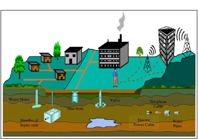
Water Meter
Handles of Septic tank
Valve
Man Hole
Electric
Power Cable Water Pipes Telephone
Cable
Fig. 2. The anticipated view for 3D Navigation for 3D-GIS.
4. FINAL REMARKS AND FURTHER WORKS
This paper has discussed a few problem arise in implementing 3D naviga-tion for 3D-GIS. An investiganaviga-tion on the support of naviganaviga-tion in real world environment will be carried out to find techniques and solutions for 3D navigation. Several research ideas and some initial requirements of 3D navigation solution towards 3D-GIS also been discussed. To make it more understandable, a simple viewing prototype has been developed as an ini-tial stage of implementation. Eventually, this paper will serve as a starting point for a more challenging research effort and the will be part of on go-ing research program on 3D-GIS.
thus making it hard for user to recognized it. The map display buildings or any place of interest as a point feature or as a square box. User interaction with map is not possible, thus information (attributes) for each map fea-tures is not shown completely.
Although, there are a few of works devoted to 3D navigation, the re-search is concentrated around a few basic rere-search ideas. Integration of 3D navigation with current direction and technology for 3D-GIS raises re-search topics at a database level toward standard object descriptors and op-erations. It is expected that the outcome of this research could help laymen who often have trouble in understanding or interpreting complex data, but also can help experts in decision making. It is hope further works could fo-cus on data regeneration and management for 3D-GIS. Still 3D-GIS func-tionality needs to be addressed: 3D buffering, 3D shortest route, 3D inter-visibilities are some of the most appealing for research for integrating with 3D navigation system.
REFERENCES
Coors, V. and Flick S., 1998. Integrating Levels of Detail in a Web-based 3D GIS. Coors, V. and V. Jung, 1998. Using VRML as an Interface to the 3D data
ware-house, in: Proceedings of VRML'98, New York.
Finley, Darel. R., 1998. Point-In-Polygon Algorithm.
http://www.alienryderflex.com/polygon/
Guéziec, A. et al. Simplicial Maps for Progressive Transmission of Polygonal Sur-faces. Third Symposium on the Virtual Reality Modeling Language, Mon-terey, California, USA, 1998, ACM Press.
M. Abdul Mannan and Bogdahn Juergen, 2004. Virtual Environments in Planning Affairs, in 20th ISPRS Proceedings, Istanbul, Turkey.
Morley, Chris, 2002. Tool: libVRML97
http://www.vermontel.net/~cmorley/vrml.htm
User Guide, Cortona SDK 4.1 http://www.parallelgraphics.com/developer/
Uwe Jasnoch, Volker Coors and Ursula Kretschmer, 2000. Applications of 3D-GIS.
Van Driel, Nicholas J., 1989. “Three dimensional display of geologic data”.
VRML ’97 Specification.
http://www.web3d.org/x3d/specifications/vrml/ISO_IEC_14772-All/index.html.