preliminary findings
Muhammad Imzan Hassan1, Alias Abdul Rahman1 and Jantien Stoter2
1
Department of Geoinformatics, Faculty of Geoinformation Science and Engineering, Universiti Teknologi Malaysia, 81310 Skudai, Johor, Malay-sia. Email: {imzan, alias}@fksg.utm.my
2
Department of GeoInformation Processing, International Institute for GeoInformation Science and Earth Observation (ITC), Enschede, The Netherlands. Email: [email protected]
Abstract
realis-tic and meaningful information to users. With the rapid development of hardware, software and knowledge, we believed Malaysia are ready to de-velop a 3D Cadastre System to solve the problems with the complexity of cadastral registration of 3D property situations. In Malaysia, hybrid 3D ca-dastre will be discussed as this model was proposed by previous research work, i.e. Stoter (2004). However, the design system should be realistic and practical to be applied based on Malaysian cadastral environment ei-ther on regulation or historically. The aim of this paper is to discuss some initial literature reviews of the subject or problem with respect to current 2D Cadastre System and 2D registration system in Malaysia. The early findings of the problems will be served as starting point in developing and addressing a much bigger problem for a PhD research work.
Key words: 3D registration system, 3D database, 3D cadastre.
1
Motivation
Traditionally, cadastral registration systems are parcel-based systems, since the individualization of land started with a subdivision of land using 2D boundaries. A country is divided into parcels, where rights and limited rights on property are established and registered on 2D land parcels. This 2D cadastral concept has served its purposes for decades. 2D cadastre mapping being practice in Malaysia and at the moment it provides vital land and property information like ownerships of the parcels for most parts of the country. The current 2D cadastre system is regularly updated both in rural and in urban areas by the national survey agency (NMA), i.e. the De-partment of Survey and Mapping (JUPEM). Typical information related to parcels and property ownerships like parcel numbers or IDs, parcel’s ge-ometry and dimensions, etc. are digitally available. The ownership infor-mation (who owns what) comes from Land Offices and all these informa-tion are considered two-dimensional (2D) in nature. Obviously current cadastral information serves most of the users need. However in very near future these 2D information may not be able to serve for serve more ad-vanced situations for example in large city centers. One way to deal with this situation is by having a more advanced cadastral system like 3D ca-dastre. This means we need to extend the 2D system into a three-dimensional (3D) (Abdul-Rahman, et al, 2005).
cen-tres have led to overlapping and interlocking constructions. Underground infrastructure like number of tunnels, cables and pipelines, underground parking places and shopping malls are not only involve a single parcel but covered by a series of parcels (on the surface). The existence of this cross-boundary infrastructure, raise the question about the property rights in-volved and how to register these rights. Even when the creation of property rights to match these developments is available within existing legislation, describing and depicting them in the cadastral registration poses a chal-lenge. The challenge is how to register overlapping and interlocking con-structions when projected on the surface in a cadastral registration that reg-isters information on 2D parcels. Although property has been located on top of each other for many years, it is only recently that the question has been raised as to whether cadastral registration should be extended into the third dimension. The growing interest for 3D cadastral registration is caused by a number of factors such as; a considerable increase in (private) property values; the number of tunnels, cables and pipelines (water, elec-tricity, sewage, telephone, TV cables), underground parking places, shop-ping malls, buildings above roads/railways and other cases of multilevel buildings has grown considerably in the last forty years; an upcoming 3D approach in other domains (3D GIS (Geographical Information Systems), 3D planning) which makes a 3D approach of cadastral registration techno-logically realizable (Pilouk, 1996; Zlatanova, 2004; Abdul-Rahman, 2000).
This paper discusses some motivation factors in Section 2 and describes current cadastre practices in Malaysia in Section 2. We discuss the possi-ble cadastre models in Section 3 and the hybrid approach in Section 4. Fi-nally, the remarks and further works are highlighted.
2
Current Situation in Malaysia
2.1 The National Mapping Agency (NMA)
Jabatan Ukur dan Pemetaan Malaysia (JUPEM) is a National Mapping Agency (NMA) for Malaysia and the custodian for the spatial data. The increasing demands for digital cadastre data from users (government and private agencies) led JUPEM to this centralized database.
Digital Cadastral Database (DCDB)
The development of DCDB by JUPEM is to cater the needs of cadastre survey data management and with the DCDB the cadastre data manage-ment would be more effective. The data in the DCDB can be integrated with the data from Computerized Land Registration System (CLRS) at Land and Mines Office (PTG). Currently, DCDB stores lot/parcel spatial data in two representations, raster and vector format. Previously JUPEM stored the spatial cadastre data in analog format (paper format). In DCDB the entire paper map have been scanned and converted into digital
DCDB Data Structure
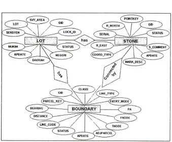
The DCDB has been developed by using relational database. It has three layers, namely,
Cadastre Lot Layer (LOT.shp)
Boundary Line Layer (DYH.shp)
Boundary Stone Layer (STONE.shp)
2.2 The Land and Mines Office (PTG)
In 1992, PTG has introduced Computerized Land Registration System (CLRS). The purpose of introducing CLRS is to modernize the manual transaction into computerized system. The introduction of CLRS is to in-crease work productivity at land offices.
Computerized Land Registration System (CLRS)
CLRS is an online system that operates using a UNIX based server. The CLRS main users are Land Office and Minerals (state), and Land Office (district). The registration of land can only be done by a registrar of the re-spective offices and the land registration information can only be obtained from the local network in the responsible offices.
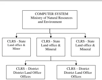
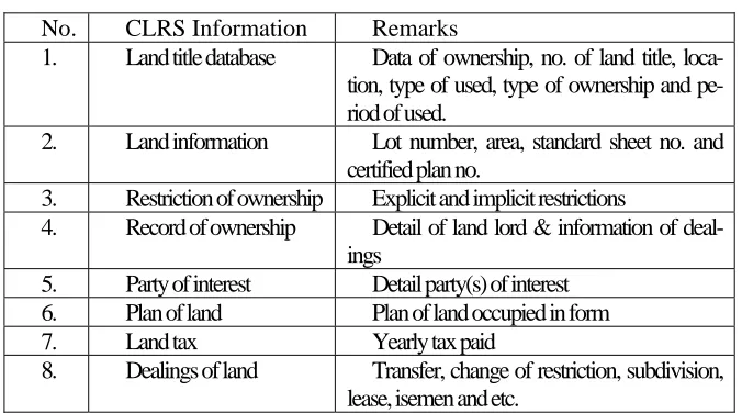
The general structure of CLRS configuration can be seen in Figure 2. Ministry of Natural Resources and Environment is the agency that super-vised the CLRS. The registration of land can either be registered at the State Land Offices and Mineral or District Land Offices. The system used Oracle database to organize the recorded data. The information recorded in the CLRS database as shown in Table 1.
COMPUTER SYSTEM Ministry of Natural Resources
and Environment
CLRS - State
Land office & Miner
CLRS – District District Land Office
Offices
CLRS – District District Land Office
Offices
CLRS - State Land office &
Mineral CLRS - State
Land office & Mineral
No. CLRS Information Remarks
1. Land title database Data of ownership, no. of land title, loca-tion, type of used, type of ownership and pe-riod of used.
2. Land information Lot number, area, standard sheet no. and certified plan no.
3. Restriction of ownership Explicit and implicit restrictions
4. Record of ownership Detail of land lord & information of deal-ings
5. Party of interest Detail party(s) of interest 6. Plan of land Plan of land occupied in form
7. Land tax Yearly tax paid
8. Dealings of land Transfer, change of restriction, subdivision, lease, isemen and etc.
3
The Possible Models
3D cadastre could be implemented by using three possible approaches, i.e. full approach, hybrid approach, and the simple 3D tag approach as pro-posed by Stoter (2004).
3.1 Full 3D Cadastre
In a full 3D cadastre, 3D space (universe) is subdivided into volumes parti-tioning the 3D space. The 3D parcels form a volume partition (no overlaps or gaps in 3D). Relationships between two 3D parcels may be necessary to take care of for example the accessibility of a 3D parcels which is not di-rectly connected to the surface. In a complete implementation of a full 3D cadastre, the only real estate objects that are recognized by the cadastre are 3D parcels (bounded in all dimensions) and the 3D parcels form a com-plete partition of space. It is no longer possible to entitle persons to infinite parcel columns, defined by surface parcel boundaries, but only to well de-fined (and totally bounded), surveyed volumes. It requires a total renewal of the cadastre. However it also can be done with the conversion of the conventional representation of parcels into the third dimension: a parcel is
no longer only defined by the parcel boundary but also by an infinite (or actually indefinite) parcel column that intersects with the surface at the lo-cation of the parcel boundary. In this alternative cadastral registration of the whole country is converted into 3D. With this approach, full 3D cadas-tre still has a strong link with current cadastral registration: traditional 2D situations (parcels with only one person entitled to it) can be kept largely unchanged. The UML class diagram of this solution is shown in Figure 3.
3.2 Hybrid 3D Cadastre
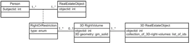
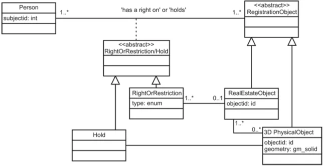
The hybrid approach is basically a registration of 2D parcels in all cases of real property registration and additional registration of 3D legal space in the case of 3D property units. This approach means preservation of 2D ca-dastre and the integration of the registration of the situation in 3D by regis-tering 3D situations integrated and being part of the 2D cadastral geo-graphical data set. The 3D representation can be either the volume to which a person is entitled to or a physical object itself.
Registration of 3D right-volume
A 3D right-volume is a 3D representation of the legal space related to a (limited) right (or apartment right) that is established on a parcel and con-cerns a 3D situation, for example the right of superficies, established for a tunnel, refers to a volume below the surface. The landowner is restricted in using the whole parcel column and the volume that is ‘subtracted’ from this parcel column is visualized in 3D as a 3D right-volume as part of the cadastral map in a 3D environment. The right-volume is only registered for the person, which is entitled to the bounded volume, while the spatial ex-tent of the property of the bare owner can be derived from the registered information.
Rights are still always established (and registered) on surface parcels. A 3D right-volume is extended into 3D (’extruded’) by means of defining the upper and lower limits of the right. The upper and lower limits of 3D right-volumes are initially defined with horizontal planes. This type of registra-tion is sufficient to warn the user that the landowner is restricted in using the whole parcel-column. It also gives an indication on the space to which the limited right applies. More precise information (with juridical status) can be obtained from deeds and survey plans archived in the land registra-tion. If it will be possible in the future to register a real right on only part of a parcel, a 3D right-volume can be defined as a polyhedron located anywhere within a parcel. The first aims of 3D right-volumes are to warn the users something is located above or below the surface and to indicate approximately the space where this ‘something’ is located. Therefore the quality of the 3D representations should be exact enough for practical use. All the parties involved should agree on the upper and lower levels of the 3D right- volumes. The levels should be laid down precisely in the con-cerning deeds and survey plans. Based on this information the 3D right-volumes can be generated and inserted in the cadastral registration. The UML class diagram of 3D right-volumes is shown in Figure 4. The 3D right-volume is a 3D representation of the right, of which the geometry is
maintained in the DBMS as type gm solid, which is a geometry type de-fined by OGC and ISO.
The most basic improvement of the registration of 3D right-volumes compared to the current cadastral registration is that the 3D extent of rights can be visualized in one integrated view in the cadastral map and not only per parcel in isolated visualizations. Furthermore, the 3D situations can be queried since the 3D right-volumes are linked to non-spatial information in the cadastral database in contrast to the (scanned) drawings available in a cadastre containing only tags to 3D situations.
Registration of 3D physical objects
The registration of physical objects is independent from the question of whether there have been rights established and registered on the intersect-ing parcels. The physical objects are added for the same purpose in the ca-dastral geographical data set as buildings: to link caca-dastral registration with representations of reality (i.e. topography) for orientation and
refer-ence purposes. A physical object is a construction above or below the sur-face which may cross parcel boundaries. In the case of physical objects, the objects themselves are registered and not the 3D legal space (as in the first alter- native). The legal space is the space to which the holder of a physical object wants to have a right to ensure the property of the object, which is usually larger than the physical extent of the object itself (for ex-ample including a safety zone. The main objective of the registration of physical objects is to reflect the construction itself.
A registration of 3D physical objects needs to be organized and main-tained and this registration will become a cadastral task. In the cadastral
registration spatial as well as non-spatial information on the whole 3D physical object is maintained. A 3D physical object can be queried as a whole. For example, which parcels are intersecting with (the projection of) a 3D physical object (this is a spatial query)? Which rights are established on these parcels? Who are the associated persons? The solution of register-ing 3D physical objects (includregister-ing geometry in 3D) meets the need of a 3D cadastre to register constructions themselves, or at least to have the loca-tion of physical objects available in the cadastral registraloca-tion (and included in the cadastral map). A 3D description of physical objects can be used if the cadastral map is available in 2.5D. A limited right still needs to be es-tablished on the intersecting parcels referring to the physical object to ex-plicitly secure the legal status (the 2D parcel is still the basic entrance for establishing real rights and for the cadastral registration). Since the physi-cal objects are integrated in the cadastral geographiphysi-cal data set, the real situation is much better reflected than in the current cadastral registration. For the registration of 3D physical objects the UML class diagram in Fig-ure 5 applies.
The only right that a person can get on a 3D physical object is that he can become the holder of this object. A 3D physical object is not a spe-cialization of real estate objects: 3D physical objects are maintained in ad-dition to parcels and parcels are still the basic entity of registration. Sur-face parcels (defined in 2D or 2.5D) are still always needed to ensure the legal status in 3D.
We have described the two possible approaches and few models for 3D cadastre; the approaches have positives and negative points. Malaysia could embark on this 3D cadastre system relatively straight forward since it has good 2D cadastre framework. From the foregoing discussion it can be realized that the hybrid approach certainly would be a good to start with. Experiences from researchers show that this 3D technology in cadas-tre has to be embedded with the legal entity before it can be fully imple-mented and realized.
4
The Hybrid Approach for Malaysian 3D Cadastre
cadastral works involve several processes such as ownership registration, cadastral survey and others. It is good to have one organization that deal with the cadastre system in a country. However, in reality, e.g. in Malay-sia, the idea seems difficult to be realized. This is due to historical reason.
From the previous section, it is clear that both agencies are using Oracle DBMS for the databases (CLRS Database and DCDB) where DCDB stores the spatial and geometric information while CLRS Database stores the none spatial information of the land registration. Technologically, it is possible to have a link between the same DBMS tools. The structure and the schema of both databases have to be well defined before the two data-bases can be integrated.
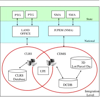
Referring to the schematic diagram as shown in Figure 6, the two sepa-rated databases can be linked to each other by using the Unique Parcel Identifier (UPI). Each none spatial record in the CLRS Database has a unique identifier that eventually can be linked to the appropriate record in the DCDB. Then the same identifier can be used to identify the lot/parcel in the proposed 3D Cadastre object database. Because of 3D component in the 3D cadastre also represent the lot/parcel geometrically in the 3D
repre-3D Lot/Parcel Da-CDMS
PTG
LAND OFFICE
SMA
UPI CLRS
Database
DCDB
CLRS
State
National
Integration Level Fig. 6. The schematic diagram of applying 3D Cadastre into the existing system
PTG SMA
sentation, so this 3D database should be managed by NMA. From the foregoing discussion it can be realized that the hybrid approach certainly would be a good starting point for having 3D Cadastre in Malaysia.
5
Remarks and Further Work
From the foregoing discussions it can be realized that most of the existing 2D cadastre systems are hardly able to provide more realistic information to users like property owners, etc. Obviously, such 2D system inevitably needs to be upgraded to cater for the next generation of information com-munity including cadastre comcom-munity in Malaysia. Attempts to address the 3D cadastre have been carried out in several countries like in the Nether-lands, Australia, Sweden, Finland, British Colombia (Canada), and Israel, but most of these works are still not operational and still needs a lot of re-search efforts before it could be fully implemented and realized. As far as Malaysia is concerned the needs for this research output is clearly sought after by the National Mapping Agency (NMA), i.e. JUPEM. The aspect of 3D property registration as well as in the technical aspect such as the 3D modelling and 3D geo databasing are the focus of this research. This re-search also attempts to address integration issue, i.e. existing 2D system to 3D system (hybrid approach). The detail experiment on the mentioned problems will be carried out in the very near future and certainly a proto-type of 3D cadastre that works with existing Malaysia cadastre framework is our next task.
REFERENCES
Abdul-Rahman, A. and J. E. Stoter (2005). 3D Cadaster in Malaysia – how to
re-alize it? 7th. Surveyors Congress, Petaling Jaya, Selangor, Malaysia.
Abdul-Rahman, A. and J. E. Stoter, A.F. Nordin (2005). Towards 3D Cadaster in
Malaysia. International Symposium and Exhibition on Geoinformation (ISG
2005). Penang, Malaysia.
FIG (1995). The FIG Statement on the Cadastre. Technical Report Publication 11, Federation International des G´eom`etres, Commission 7, 1995.
Genggatharan, M. (2005). Conceptual Model for Integration of Cadastral Data
Management System (CDMS) and Computer Land Registration System (CLRS). MSc. Thesis, Universiti Teknologi Malaysia. (In Malay)
KPTG (1997). Manual Sistem Pendaftaran Tanah Berkomputer: Latihan kepada
Pendaftar. Department of Director General of Lands and Mines. (In Malay)
KPTG, Manual Sistem Pendaftaran Tanah Berkomputer: Bidang Liputan SPTB. Department of Director General of Lands and Mines. (In Malay)
National Land Code (1965).
Omar, A.H. (2003). The development of Coordinated cadastral System for
Penin-sular Malaysia. MSc. Thesis, Universiti Teknologi Malaysia.
Stoter, J.E., M.A. Salzmann, P.J.M. van Oosterom and P. van der Molen (2002),
Towards a 3D Cadastre, FIG XXII/ACSM-ASPRS, 19 - 26 April, 2002,
Washington, USA.