UNIVERSIDAD CARLOS III DE MADRID
TESIS DOCTORAL
VANET-Based optimization of
infotainment and traffic efficiency
vehicular services
Autor: Marco Gramaglia
Directores: Dr. Mar´ıa Calder´on Pastor Dr. Carlos Jes´us Bernardos Cano
DEPARTAMENTO DE INGENIER´IA TELEM ´ATICA
Acknowledgments
Me gustar´ıa agradecer primeramente a mis directores de tesis, Mar´ıa y Carlos Jes´us, por todos los conocimientos que me hab´eis transmitido durante estos cuatro a˜nos. Then, I would like to thank the institution and the people that made possible this thesis by supporting it: the Institute IMDEA Networks and its directors during these years: Arturo Azcorra and Albert Banchs. Quindi, voglio ringraziare la mia famiglia: Lara, Dina e Giovanni che mi hanno aiutato durante tutti questi anni. Adems quiero agradecer, en orden abierto: Andr´es, Pablo, Antonio, Manolo, Isa´ıas, Goyo, Ignacio, Isa, Jos´e Pablo, V´ıctor, David, Isaac, Iv´an, Jos´e Alberto, Alberto, Richi, Chema, Elvira, Rub´en, ´Angel, Paul, Andra, Fabio, Mika, Alex y otras personas de las que seguramente me olvido y que me apoyaron de manera directa o menos (aunque s´olo sea por aguantarme) durante todo este tiempo. Dulcis in fundo, tutta la gente di Macellai e dintorni, che non mi ha fatto mai mancare la sua amicizia: Teo, Mona, Davide Inge, Gian Marco, Massimo, Dario, Nicola e Davide Barb.
Resumen
El dise˜no, normalizaci´on y futuro despliegue de los sistemas de comunicaci´on vehic-ulares han sido principalmente impulsados hasta el momento por las aplicaciones de se-guridad vial. Hay dos aspectos adicionales de las redes vehiculares que han visto crecer su relevancia en los ´ultimos a˜nos: los servicios de Infotainment y los de eficiencia del tr´afico. Estos servicios pueden mejorar la experiencia de los conductores y hacer que los sistemas de comunicaci´on vehiculares resulten m´as atractivos para los usuarios finales. En esta tesis, se proponen mecanismos de optimizaci´on para ambos tipos de servicios vehiculares. Los servicios de Infotainment est´an relacionados con la provisi´on de las cl´asicas aplica-ciones IP tales como, navegar, acceder al correo electr´onico, o a las redes sociales. Los servicios de eficiencia de tr´afico permiten a˜nadir nuevas funcionalidades a los sistemas de navegaci´on con los objetivos de: optimizar el uso de las infraestructuras viarias, reducir los tiempos de viaje y consecuentemente, minimizar el impacto ambiental. Acceder a los servicios de Infotainment desde redes vehiculares conlleva cumplir con los protoco-los y mecanismos estandarizados que permiten la interconexi´on de redes heterog´eneas a Internet. Hay tres funcionalidades principales que tienen que ser proporcionadas: con-figuraci´on autom´atica de direcciones, encaminamiento eficaz y gesti´on de la movilidad. Esta tesis propone mecanismos para hacer frente a los tres aspectos mencionados: una t´ecnica basada en overhearing que mejora un protocolo de configuraci´on autom´atica de direcciones ya estandarizado, un algoritmo de encaminamiento basado en ´arboles espe-cialmente dise˜nado para las comunicaciones desde el veh´ıculo a Internet y, un algoritmo de gesti´on de la movilidad optimizado para entornos vehiculares. En cuanto a los servicios de eficiencia de tr´afico, esta tesis propone dos algoritmos que utilizando las t´ecnicas de comunicaci´on veh´ıculo a veh´ıculo permiten monitorizar y pronosticar a corto plazo las condiciones en el tr´afico, como es el caso de posibles atascos.
Todos los algoritmos y modelos anal´ıticos descritos en esta tesis han sido validados a trav´es de simulaciones y/o implementaciones usando hardware est´andar.
Palabras clave: redes vehiculares, comunicaciones inal´ambricas, configuraci´on au-tom´atica de direcciones, encaminamiento, eficiencia del tr´afico.
Abstract
The design, standardization and future deployment of vehicular communications sys-tems have been driven so far by safety applications. There are two more aspects of the vehicular networking that have increased their importance in the last years: infotainment and traffic efficiency, as they can improve drivers’ experience, making vehicular commu-nications systems more attractive to end-users. In this thesis we propose optimization mechanisms for both types of vehicular services.
Infotainment services are related to the provision of classic IP applications, like browsing, reading e-mail or using social networks. Traffic efficiency services are those accessing new capabilities to the car-navigation systems, aiming at optimizing the usage of road infras-tructures, reducing travel times and therefore minimizing the ecological footprint. Bringing infotainment services to the vehicular environment requires to comply with stan-dard protocols and mechanisms that allow heterogeneous networks to be interconnected in the Internet. There are three main functionalities that have to be provided: i) address autoconfiguration, ii) efficient routing andiii) mobility management.
Regarding infotainment services, this thesis proposes mechanisms tackling the above-named aspects: an overhearing technique to improve an already standardized address autoconfiguration protocol; a tree-based routing algorithm especially tailored for vehicle-to-Internet communications and an optimized mobility management approach for vehic-ular environments.
Regarding traffic efficiency, this thesis proposes two algorithms that make use of vehicular communication techniques to monitor and forecast short-term traffic conditions. We first improved our knowledge on drivers’ behavior by analyzing real vehicular data traces, and proposes a mixture model for the vehicles interarrival time. This outcome was used for validating the proposed infotainment optimization as well.
All the algorithms and analytical models described in this thesis have been validated by simulations and/or implementations using standard hardware.
Keywords: Vehicular networks, wireless communications address autoconfiguration, routing, traffic efficiency.
Contents
Acknowledgments i
Contents ix
1 Introduction 1
1.1 Background . . . 3
1.2 Overview and Summary . . . 5
I Infotainment optimizations 9 2 Efficient IPv6 address autoconfiguration 11 2.1 State of the art . . . 12
2.1.1 ETSI TC ITS IPv6 Integration System Architecture . . . 13
2.2 ETSI Stateless address autoconfiguration . . . 15
2.3 Effectiveness of Vehicular Multi-hop Communications . . . 18
2.4 Analytical Characterization of the ETSI SLAAC’s Performance . . . 25
2.5 Experimental Evaluation and Configuration guidelines . . . 30
2.6 Reducing the IP address auto-configuration time and signaling overhead . 34 2.7 Overhearing-Assisted Optimization for ETSI SLAAC . . . 35
2.7.1 Solution overview . . . 35
2.7.2 Overhearing probability . . . 36
2.8 Evaluation . . . 41
2.8.1 IP address configuration time . . . 41
2.9 Performance Analysis and Evaluation . . . 46
2.9.1 Signaling savings . . . 49
2.9.2 Impact on the handover . . . 49
2.10 Summary . . . 52
3 Hybrid position based routing 53 3.1 State of the art . . . 54
3.2 TREBOL . . . 55
3.2.1 Address Autoconfiguration Support . . . 57
3.3 Simulation results . . . 59
3.3.1 Simulation environment . . . 59
3.3.2 Results analysis . . . 60
3.4 Implementation . . . 62
3.5 Implementation results . . . 65
3.6 Summary . . . 68
4 Seamless Internet Cellular and Opportunistic WLAN Vehicular Connectivity 69 4.1 State of the art . . . 70
4.2 Background . . . 71
4.2.1 Basic Internet connectivity provision: Network Mobility . . . 73
4.2.2 Offloading the 3G network: flow mobility . . . 74
4.2.3 Multi-hop WLAN vehicular Internet connectivity: addressing and routing 76 4.2.4 Seamless Interface Management: vehicular-aware IEEE 802.21 . . 76
4.3 Protocol operation . . . 80
4.4 Evaluation . . . 84
4.4.1 Evaluation framework . . . 84
4.4.2 Results and performance analysis . . . 86
4.5 Comparison with previous work . . . 92
CONTENTS ix
II Traffic efficiency optimizations 95
5 Vehicular trace analysis 97
5.1 Goals . . . 98
5.2 Data set description . . . 98
5.3 Analysis of the arrival process . . . 100
5.3.1 Is the arrival process a Poisson process? . . . 100
5.3.2 On the dependence between consecutive vehicles . . . 102
5.3.3 Identifying bursts of vehicles . . . 102
5.4 An exponential-gaussian mixture model of inter-arrival times . . . 106
5.5 Summary . . . 111
6 Traffic monitoring and short-term prediction 113 6.1 Current monitoring techniques . . . 114
6.2 Monitoring traffic using Virtual Induction Loops . . . 116
6.2.1 Evaluation . . . 117
6.3 Distributed traffic congestion prediction . . . 119
6.3.1 Modeling vehicular traffic . . . 120
6.4 ABEONA: VANET-assisted traffic forecasting . . . 123
6.4.1 Algorithm overview . . . 124
6.4.2 Current epoch data management . . . 125
6.4.3 Historical data record management . . . 127
6.4.4 Beacon size considerations . . . 128
6.4.5 Lack of connectivity issues . . . 129
6.4.6 Forecasting future traffic conditions . . . 129
6.5 Experimental evaluation . . . 131
6.6 Summary . . . 133
Chapter 1
Introduction
In the last few years, vehicular ad-hoc networks (VANETs) have been put into the spotlight. Car manufacturers and Public Transport Authorities have been investing on these emerging technologies, mainly driven by the goal of increasing traffic safety. New standards are being or have been proposed in the recent years, like the ones developed by institutions such as the Institute of Electrical and Electronic Engineers (IEEE) or the European Telecommunications Standards Institute Technical Committee for Intelligent Transportation Systems (ETSI TC ITS), or by consortia like the Car-to-Car Communi-cation Consortium (C2C-CC).
Besides safety-related applications, which have unique requirements of delay and priority, and are generally broadcast-based, two families of services can be identified: infotainment and traffic efficiency.
The Infotainment services are those concerning the provision of classic IP services avail-able in the Internet: browsing, reading e-mails, using social networks. Nowadays, users want to enjoy Internet applications continuously, not only when at home or at work. With the increasing success of the ubiquitous computing paradigm and the embedding of smart devices into vehicles, the research in the field of infotainment services has become more
important in the recent past. Enabling infotainment services in VANETs, not only im-plies providing efficient communications within the vehicular environment, dealing with the unique mobility characteristics of vehicles; but also complying with standard mecha-nisms and techniques currently used in the Internet.
The second type of services, traffic efficiency, aims at exploiting the ability of forming short-range wireless multi-hop networks to achieve a better usage of road infrastructure hence decreasing the time spent traveling by car and reducing the pollution. By smartly routing vehicles accordingly to the traffic conditions, traffic jams can be avoided, reducing travel times. Vehicles can be used to cooperatively exchange information in real time and warn other vehicles about current or near future congestion.
Among all the open issues that are present in the vehicular networks environment, this thesis focuses on both the aforementioned problems: providing Internet access from vehi-cles (i.e., infotainment service) and using the VANET paradigm to monitor and forecast the vehicular traffic conditions.
If we look at infotainment services, bringing IP connectivity to VANETs is the main challenge. In order to do so, the following three main aspects have to be addressed:
a) vehicles have to be able to autoconfigure an IP address,
b) an efficient routing of IP datagrams from/to the vehicular network is required,
c) IP mobility mechanisms have to be tailored for vehicular scenarios.
In this thesis we propose a solution to efficiently solve each one of the previously intro-duced functionalities: a) an analytical model and an enhancement of an existing efficient IPv6 address autoconfiguration mechanism (GeoSAC),b)a hybrid position based routing for vehicle-to-Internet communications (TREBOL); andc)a smart IP mobility algorithm for an efficient use of the available access technologies (SILVIO).
Multi-hop communications in a vehicular environment are heavily influenced by vehicles’ mobility. The presence of connectivity gaps between consecutive vehicles can lead to the unfeasibility of communication through a multi-hop path.The work developed in this the-sis could count on data coming from vehicular traffic measurement points in the city of Madrid. To analyze these data traces, especially in terms of interarrival times between consecutive vehicles, it not only useful to evaluate the performance of the analytical mod-els proposed throughout the thesis, but also to provide insights on drivers’ behavior. This thesis proposes a novel approach to model the distribution of interarrival times that takes into account the interactions between close vehicles.
1.1. Background 3
perform. The installation and the possible relocation of the monitoring hardware is expen-sive and gives a reduced flexibility to the systems. Applying VANET-based techniques to gather the current traffic conditions will reduce the cost and increase the flexibility of the service, contributing to a more capillary dataset of real-time measurements. As VANETs can form a self configured network, vehicles can exchange information among them and gather metrics that cannot be captured using the currently used solutions. In this thesis we propose two solutions for traffic monitoring and short term forecast that exploit vehicular communication.
In order to improve the readability of the thesis, we divided it into two parts. The first one is about the optimization of infotainment services, and includes the proposals that directly deal with the problem of providing Internet connectivity from vehicular envi-ronments. The second one tackles the problem of traffic efficiency, and comprises our findings in the field of the vehicular flow analysis and their use in traffic monitoring and forecasting systems.
1.1
Background
There is already a quite extensive state of the art in the field of non-safety based services for vehicular networks, both for infotainment and traffic efficiency. Providing support for IP based services in VANETs is a complex problem that raises a large num-ber of heterogeneous issues. As already stated previously, there are three main func-tionalities that have to be carried out: address autoconfiguration, routing and mobility management. Despite the common goal of these three research fields, they can be tackled somehow independently, as each one is considering a different piece of the problem. Many of the already proposed solutions are inspired by mobile ad-hoc network (MANET) solu-tions, with modifications in order to deal with VANETs characteristics (i.e., nodes high mobility).
The multi-hop nature of VANETs and the absence of a single multicast-capable link for signaling, typically makes the use of standard IPv6 autoconfiguration protocols, both stateless (Stateless Address Autoconfiguration, SLAAC) and stateful (Dynamic Host Con-figuration Protocol, DHCPv6), impossible to be used without any modifications. Several proposals in the literature [1,2] introduce modified versions of DHCP, adapted to work in VANETs environments. Using a stateless mechanism like IPv6 SLAAC offers advantages in terms of scalability as it does not rely on a central entity (or a federation of delegates). This architecture is studied in [3, 4]. The solution proposed in [3] is the basis of the work further described in Chapter 2.
adoption of geographic based solution as a common choice for routing in vehicular net-works. Numerous solutions like [5], [6] base their operation on additional VANET-related information such as position of gateways, traffic statistics or trajectory estimation. This extra information is however difficult to gather and expensive (in terms of overhead) to keep up-to-date. The work described in Chapter 3 consists in a routing algorithm for vehicle-to-Internet communications that exploits the geographic location knowledge of the nodes.
Deploying a wireless-based access network for vehicular environments is a difficult task. The deployment of access points to the backhaul network cannot be as dense as needed for a complete direct coverage, due to the high installation costs. Giannoulis et al. [7] already proposed mechanisms to efficiently handoff between access points, but without a full wireless coverage seamless connectivity is impossible to achieve. The adoption of a multi-hop communication protocol allows a larger number of nodes to enjoy Internet connectivity via the wireless-based access network but, on the other hand, poses problems of path-stability.
Using the cellular network, vehicles can achieve an “always on” connectivity, but it con-tributes to add more traffic to an already congested network1. In [8] the authors show that, by conveniently switching between access technologies, vehicles can offload a not negligible part of their traffic to the wireless-based access networks. The work outlined in Chapter 4 designs a mechanism for efficiently exploiting both the access technologies, using the cellular network as the default access network, but offloading some non-critical flows when a wireless-based network becomes available.
The second part of this thesis deals with traffic efficiency services. A first useful step is to better understand drivers’ behavior as the performance of multi-hop wireless network protocols heavily depends on the availability of the used paths, that is directly influenced by the vehicles’ mobility patterns and interactions. The Spanish General Directorate of Traffic and the Madrid City Council, kindly provided us with real vehicular traffic mea-surements, coming from fixed observation points in the city of Madrid. We used them to develop a model of the interarrival times between vehicles, and have an useful overview about how they can successfully communicate among them using wireless devices (either radio based, infrared [9], or using visible light communications [10, 11]). While previous studies showed that interarrival times between consecutive vehicles can be modeled using an exponential [12] or a lognormal distribution [13], we found a relation between the used probability distribution and the drivers behavior. Chapter 5 details the procedure we used to analyze the vehicular trace dataset and the steps taken to build an exponential-gaussian based mixture model.
The analysis of the interactions among vehicles is not just useful for studying the effective-ness of networking algorithms. Public transportation authorities are nowadays constantly
1.2. Overview and Summary 5
monitoring the traffic state in their principal arteries, and there are commercial solutions that add real time traffic information to the navigation system capabilities. Currently, the devices used for monitoring purposes are expensive and difficult to deploy. Results very similar to the ones obtained by a legacy solution can be achieved by applying VANET-based monitoring solutions, without incurring into high installation costs and providing more flexibility to the monitoring system. Moreover, as vehicles are cooperating and act-ing as distributed sensors, more than one traffic variable (flow,density andspeed) can be gathered at the same time. A previous work [14] shows that the vehicular traffic demand can be short-term forecast using the value of these traffic variables from the recent past. The work described in Chapter 6 exploits Inter-vehicular communication (both among ve-hicles and between veve-hicles and the fixed infrastructure) to provide a solution for cheaper and efficient vehicular traffic monitoring and forecasting.
1.2
Overview and Summary
The contributions of this thesis are summarized as follows. This thesis first proposes solutions to optimize the provision of infotainment services in VANETs: a model and an enhancement of the IP address autoconfiguration mechanism standardized by ETSI; a tree based routing protocol for VANETs and a mobility solution for heterogeneous inter-net access from vehicular inter-networks. Furthermore, an interarrival time between vehicles analysis based on real traces is used in order to validate the effectiveness of the proposed infotainment solutions, but also as basis for the design of traffic efficiency solutions, namely two proposals for the efficient vehicular traffic monitoring and forecasting of its future values.
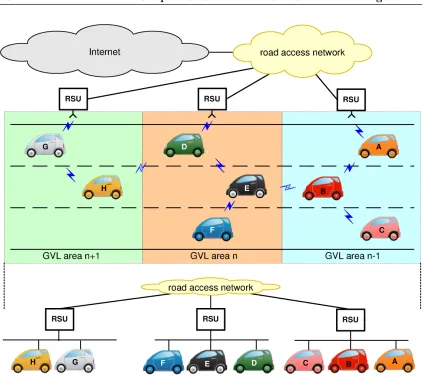
The first contribution of this thesis is to model and enhance GeoSAC (Geographi-cally Scoped stateless Address Configuration) [3] which is an adaptation to VANETs of the standard IPv6 SLAAC (Stateless Address Autoconfiguration) mechanism, built on top of the ETSI TC ITS system architecture, that was subsequently standardized as ETSI SLAAC. ETSI SLAAC supports geographic addressing and networking, by extending the concept of an IPv6 link to a specific geographic area associated with a point-of-attachment (called Geographical Virtual Link, GVL). The network is intended as composed by vehicles (that carry On Board Units - OBUs) and Road Side Units (RSU) that form a self-organizing wireless network. RSUs periodically send out Router Advertisement (RA) messages which reach the nodes currently located within a well-defined area, and the nodes can then generate IPv6 addresses appending their network identifier derived from the MAC address to the received IPv6 prefix.
configuration time. When using ETSI SLAAC, the vehicular network is logically partitioned in non-overlapping areas by selectively filtering received RAs. However, a vehicle within radio range of others in a neighboring area also receives the messages they sent. Therefore, the performance of ETSI SLAAC (in terms of reduction of its configu-ration time and/or signaling overhead) can be improved by vehicles caching the Router Advertisements sent by other vehicles in adjacent areas and reusing them when crossing the area border, without waiting for the reception of the next Router Advertisement (vehicles are considered to be equipped with positioning devices). Simulations and imple-mentations using Commercially available Off-The-Shelf (COTS) devices show that using the proposed optimization the configuration time can be pulled down to zero under most traffic conditions and different RA configurations, obtaining a potentially seamless IP ad-dress configuration. The whole study is detailed in Chapter 2 and was published in [15,16].
The second contribution of this thesis is TREBOL [17] (Tree-Based Routing for Vehicle-to-Internet Communications), a tree-based and configurable routing protocol which benefits from the inherent tree-shaped nature of vehicle-to-Internet traffic (V2I) to reduce the signaling overhead while dealing efficiently with the vehicular dynamics. TREBOL builds the upstream routing tree by slightly modifying the Router Advertise-ment messages sent by the Road Side Units with some additional information required to construct the tree piggybacked into them. Once the tree has been built, every node has a parent node that is used as next hop for upstream (vehicle-to-Internet, V2I) traffic. This upstream tree is updated periodically by means of some lightweight signaling sent by the Road Side Unit. For downstream traffic, nodes keep soft-state about routes for currently used destinations. Furthermore, the protocol could also be used to allow nodes to autoconfigure IPv6 addresses when used in conjunction with our GeoSAC overhearing optimization, reducing even more the overall control overhead required by routing and address autoconfiguration functions. Another remarkable feature of the proposed protocol is the wide range of deployment scenarios, mostly defined by the size of the TREBOL area where it may operate, making it suitable for both urban and highways scenarios.
The protocol is validated using a real trace driven simulator and the results show that TREBOL outperforms a well known geographic routing protocol, providing better traffic delivery ratio and allowing at the same time a significant saving of control overhead, aspect considered as critical in wireless VANETs networks, as it does not introduce any beaconing mechanism. Moreover, in [18] TREBOL has been experimentally evaluated using a Linux implementation under lab-controlled realistic scenarios. The proposal is detailed in Chapter 3.
tai-1.2. Overview and Summary 7
lored for VANETs, where each well defined area is represented by an IPv6 prefix. Traveling vehicles traverse many areas during a trip, thus changing IPv6 prefix and point of attachment to the infrastructure network. SILVIO [19] (Seamless Internet 3G and Opportunistic WLAN Vehicular Internet Connectivity) is a mobility mechanism that allows to seamlessly hand off between different RSUs via a multi-hop wireless access through the VANET. However, the knowledge coming from previous works showed us that this could be sometimes unfeasible, due to a lack of multi-hop connectivity. Although using a WLAN interface is desirable because it can provide higher bandwidth, the possibly lack of multi-hop connectivity suggests its opportunistic use. SILVIO uses standardized techniques (e.g., flow mobility) and vehicular modifications of them (e.g., 802.21 Media Independent Handover), allowing to efficiently use the connectivity through the VANET when available. Hence, our IP mobility solution for VANETs considers the possibility of using a cellular network interface as default option, conveniently offloading some selected IP flows as soon as a multi-hop link to a RSU becomes available. We describe this proposal in Chapter 4.
Another contribution arose by the need for a procedure to validate the proposed analytical models. Initially, the distribution used for modeling the interarrival time between two consecutive vehicles was an exponential distribution, as it was already used in many papers in the literature. This model was firstly proposed in [20] and more recently extended by [21]. Later, we used real vehicular traffic measurements collected at different locations in several highways of the city of Madrid to feed the simulators used in [15] and [17]. The final step was to perform an analysis of the traces, checking if they matched the exponential based model.
The last contributions of this thesis relate to traffic efficiency services which have gained strength in the last few years. A study from the University of Texas2 claims that the total cost of traffic congestion in the U.S. in that year was 100 billion USD.
Current technologies used for traffic monitoring purposes suffer of high installation costs both for the work needed to embed the hardware into the road infrastructure (that can reduce the road capacity and create troubles to the traffic) and for the hardware cost itself. Moreover, current technologies are extremely difficult to relocate in case of a change of requirements.
The use of a vehicular communication based solution can solve these two particular issues. Having vehicles that cooperate by exchanging data among them (and with installed Road Side Units) to make available real time traffic information about a given stretch of road will enable a cheaper and more flexible monitoring paradigm. This outcome can be achieved either using a completely distributed vehicle-to-vehicle (V2V) communication based solution or by taking advantage of already deployed RSUs.
The theory of vehicular traffic is a well known topic that has been extensively researched in the past century. Among all the theories that came up, the Kerner’s Three-phase traffic theory [22] is one of the most considered. It introduces three possible states of the vehicular traffic: Free flow, Synchronized and Traffic jam. The transitions between the different states happen according to the variation of three fundamental variables the vehicular flow, speed and density. We designed a cooperative distributed algorithm which is able to monitor the three fundamental traffic variables, something that cannot be easily achieved using legacy standard monitoring techniques. This exercise benefited from the knowledge gained while performing the analysis of the real vehicular traces as described before.
Monitoring the traffic variables is also useful for the prediction of short-term future conditions. Our proposal keeps track of the historical series of the observed variables and makes a short term prediction of their future values. This outcome is finally used to detect a possible breakdown and, if true, warn approaching vehicles so that they can change their routes accordingly. Both the monitoring and fully distributed forecasting proposals are detailed in Chapter 6.
Finally, in Chapter 7 we discuss about the contributions of this thesis, identifying some future work.
Part I
Infotainment optimizations
Chapter 2
Efficient IPv6 address
autoconfiguration
In this chapter we focus on the auto-configuration of IP addresses by nodes of a Vehic-ular ad-hoc network (VANET). The internet was built over the robust Internet Protocol (IP) version 4, but emerging technologies like VANETs can benet from functionalities introduced by the new version (IPv6) and are therefore expected to generate a flywheel effect for its deployment. For this reason, all of the aforementioned international commit-tees dening architectures for vehicular communication have included a native IPv6 stack in their protocol stacks. IPv6 provides some standardized mechanisms of IP address auto-configuration, both stateless [23], [24] and stateful [25] that cannot – or at the very least are hard to – be applied without any modification in vehicular environments. The main causes of this fact are the multi-hop nature of VANETs and their lack of a single multicast-capable link for signaling, that prevent current IP address auto-configuration related protocol specifications from being used as-is in VANETs. Therefore, a key research issue is how to auto-configure IPv6 addresses in a VANET. The same problem occurs in general in any unmanaged multi-hop network. Among these, Mobile Ad-hoc Networks
(MANETs) have received a remarkable attention in the research area for years, and there even existed a working group in the IETF1, called AUTOCONF, that was chartered to work on the standardization of an address auto-configuration solution for MANETs [26].
2.1
State of the art
There are two main approaches that can be followed to integrate IP in a multi-hop vehicular network:
1. Making the IP layer fully aware of the multi-hop nature of VANETs. In this case, the VANET can be defined as a set of IP routers that are interconnected by a multitude of IP links. The high dynamics of each individual link strongly contributes to the overall addressing and routing management overhead. In particular, in order to understand this complexity, we recall the assumption underpinning IP routing, which requires IP addresses assigned to nodes terminating different links to belong to non-overlapping prefixes. Two IP prefixes p::/l_p and q::/l_q are non-over-lapping if and only if there is no IP address p::a/l_p configured from p::/l_p that also belongs to q::/l_q, and vice versa2. In order to enable IP routing, an overwhelming amount of short-lived routes is required, posing extremely challenging management issues.
An example of solution that falls in this category and is particularly designed for VANET environments is the Vehicular Address Autoconfiguration (VAC) solution, proposed by Fazio et al. in [1]. This solution exploits the VANETs topology and an enhanced DHCP service with dynamically elected leaders to provide a fast and reliable IP address configuration. VAC organizes leaders in a connected chain such that every node (vehicle) lies in the communication range of at least one leader. This hierarchical organization allows limiting the signaling overhead for the address management tasks. Only leaders communicate with each other to maintain updated information on configured addresses in the network. Leaders act as servers of a distributed DHCP protocol and normal nodes ask leaders for a valid IP address whenever they need to be configured. The main drawbacks of this solution are the assumption of linear topology and group movement which limits the applicability scope, the overhead due to the explicit management signaling (e.g., between leaders) and the possible security threat due to the critical tasks carried out by the leaders. Some of the solutions proposed for Mobile Ad Hoc Networks (MANETs) [26] may also be used for vehicular networks. Most of these solutions and VAC share the
1Internet Engineering Task Force: http://www.ietf.org/
2For example, 2001:DB8:1:1::/64 and 2001:DB8:1:2::/64 are non-overlapping prefixes, while
2.1. State of the art 13
problem that they require modifications to the IP stack of the nodes, as they do not rely on existing standardized IPv6 address auto-configuration solutions.
2. Hiding the multi-hop nature of VANETs from the IP layer. In this approach, the concept of IPv6 link is extended to a set of nodes which might not be directly reachable within one physical hop. A protocol located below IP presents a flat network topology, ensuring that the link seen by the IP layer includes all the nodes of the extended set, even those that are not directly reachable. In this case, existing IP address auto-configuration mechanisms could be used with minor modifications.
This last approach was followed by the European GeoNet project3, which con-tributed to the solution finally standardized by the European Telecommunications Standards Institute (ETSI). Two similar solutions have been proposed: Geographi-cally Scoped stateless Address Configuration (GeoSAC) [3], initially proposed before GeoNet started, and further developed during the lifetime of the project; and [4], that adopts this same concept but has many and essential differences in the realiza-tion. The latter solution does not assure compatibility with legacy IPv6 protocol implementations and requires the IPv6 protocol to be geo-aware.
In this chapter we focus on the solution adopted by the ETSI Technical Committee for Intelligent Transportation Systems (TC ITS), which follows the second approach, hiding the multi-hop nature of the VANET from the IP layer. We next present this system architecture and define the terms used in the rest of the chapter.
2.1.1 ETSI TC ITS IPv6 Integration System Architecture
ETSI TC ITS is developing a set of protocols and algorithms that define an har-monized communication system for European ITS applications taking into account industry requirements like in particular those coming from the Car-to-Car Commu-nications Consortium.
In the ETSI TC ITS network architecture [27], vehicles are equipped with devices called Communication and Control Units (CCUs), which implement the ETSI pro-tocol stack (see Figure 2.1, in which only the part of the stack involved in IPv6 communications is shown). Vehicles can communicate with each other or with fixed roadside ITS stations (also called Roadside Units, RSUs) installed along roads. CCUs and RSUs implement the same network layer functionalities and form a self-organizing network. RSUs can be connected to a network infrastructure, most likely an IP-based network. On-board application hosts including passenger devices at-tached to the vehicle on-board system are called Application Units (AUs). Passenger devices are assumed to have a standard IPv6 protocol stack, whereas CCUs act as
Figure 2.1: GN6ASL in the ITS station architecture.
gateways for the in-vehicle network optionally enhanced with the Network Mobility Basic Support protocol [28].
The ETSI GeoNetworking (GN) protocol [29], published in 2011, plays the role of a sub-IP layer, offering a flat network view to the IPv6 layer and dealing with the multi-hop routing within the VANET (nodes within the same area – i.e., attached to the same IP link – might not be directly reachable, but are portrayed as such by the sub-IP layer). The ETSI has standardized a protocol adaptation sub-layer referred to as the GN6ASL (GeoNetworking to IPv6 Adaptation Sub-Layer) [30] which allows for the transport of IPv6 packets by ETSI GeoNetworking protocol, enabling sub-IP multi-hop delivery of IPv6 packets. The ETSI GN geo-broadcasting capability is used by the GN6ASL in order to shape link-local multicast messages to geographical areas.
2.2. ETSI Stateless address autoconfiguration 15
Figure 2.2: IPv6 packet forwarding within an area, and affected protocol layers.
Vehicle C is not within the radio coverage of the RSU. This example shows that in a system architecture based on short range communication devices, the effective provisioning of Internet-based applications over multi-hop communication strongly depends on mobility. Single-hop vehicular Internet access based on WLAN has already been investigated in highway scenarios [31], concluding that the link between CCU and RSU is stable enough to allow for several types of applications. When considering multi-hop communication, the applicability scope of Internet-based applications might need to be reduced to lower speed scenarios (e.g., urban or semi-urban), to a proper ratio of CCUs per installed RSU and to a realistic maximum number of hops (to be determined). Section 2.3 addresses these particular issues, assessing under which conditions it is realistically feasible to support IP unicast multi-hop communications.
2.2
ETSI Stateless address autoconfiguration
The ETSI specification devoted to the integration of IPv6 and the geonetworking architecture not only describes how IPv6 packets are exchanged between ITS stations and how the GN6ASL is presented to the IPv6 layer as a link-layer protocol, but also explains how IPv6 addresses can be automatically configured by ITS stations, namely CCUs. The specification [30] only considers the use of stateless address autoconfiguration schemes, as stateful ones present higher latencies (due to the several round-trip time signaling messages) and require greater management effort. Manual configuration is also not recommended.
The ETSI solution is based on the Geographically Scoped stateless Address Config-uration (GeoSAC) solution [3], which can be considered as one particular realization of the ETSI standardized mechanism. In the rest of this thesis we refer to the ETSI IPv6 address stateless autoconfiguration solution as ETSI SLAAC.
Figure 2.3: Geographical area partitioning and IPv6 virtual link abstraction
In ETSI SLAAC, the concept of IPv6 link is extended to a well defined geographical area (i.e., GVL area) associated with a point of attachment to an infrastructure-based network that plays the role of the IPv6 Access Router (AR).
The GeoNetworking-IPv6 Adaptation Sub-Layer (GN6ASL) (see Figure 2.1) is a sub-IP layer sitting on top of the ETSI GN layer. The ETSI GN layer deals with ad-hoc routing by using geographic location information, while the GN6ASL presents to the IPv6 layer a flat network topology. Consequently, the link seen by the IPv6 layer includes nodes that are not directly reachable but are portrayed as such by the sub-IP layer (see Figure 2.1). This layer provides IPv6 with a link-local multicast capable link, the Geographical Virtual Link (GVL), which includes a non-overlapping partition of the VANET formed by all nodes within a certain geographical area (the GVL area).
2.2. ETSI Stateless address autoconfiguration 17
build a valid IPv6 address out of the included IPv6 prefix, following the standard SLAAC mechanism, i.e., the host generates an address by joining the prefix received from the Router Advertisement and the network identifier derived by its MAC address.
The link-local multicast capability emulation is achieved by relying on the geo-multicast/geo-broadcast capabilities provided by the ETSI GN layer. In particular, in order to be link-local multicast capable, an IP link must provide symmetric reachabil-ity [23], which is normally not accomplished by virtual links spanning multiple physical links due to the lack of reference boundaries. Link-local multicast packets are forwarded with geographical knowledge, so that a node processes a packet only if it was addressed to the area where the node is located. The geographic scoping provides non-variable virtual link boundaries which enable symmetric reachability. For Router Advertisements, this means that Router Advertisements must be delivered to – and only to – the nodes that are part of the same IPv6 link, nodes that are actually connected via multiple wireless hops. If a multi-hop path exists, all the nodes within the area will receive a copy of the Router Advertisement, and the IPv6 instance running above the geonetworking will process the message as if the node was directly connected to the access router that issued the message.
It is assumed that MAC addresses (or a different identifier that can be used for IPv6 address generation purposes) of vehicles are unique, at least within macro-regions where vehicles are sold and can potentially communicate with each other (e.g., a continent). This property in fact is highly desirable for security and liability reasons, as it would allow(i) forensic teams to rely on vehicular communications to reconstruct accident scenes or other critical situations and,(ii) to detect malicious nodes and reduce considerably the effects of network attacks. Despite uniqueness of identifiers, privacy of users can be protected by equipping vehicles with sets of unique identifiers to be used for limited intervals as pseudonyms [32]. These identifiers could be assigned by authorities and, when coupled with the usage of digital certificates and cryptographic protection [33], this mechanism can accomplish support for liability as well as privacy protection from malicious users (commonly referred to as revocable privacy). Assuming that the IPv6 prefix announced by the RSU is exclusively assigned to this area, the address uniqueness is verified, and therefore no Duplicate Address Detection (DAD) mechanism is required. Note that the proposed solution could be applied to multiple RSUs acting as bridges connected to one single Access Router. This might be a good deployment choice in scenarios where single-hop connectivity to the infrastructure is preferred while it is also required to reduce the number of IPv6 address changes (e.g., city environment).
gateway selection is achieved with the infrastructure having full control on it4, as only
one RSU is assigned per geographical area; (ii) a network partitioning is obtained that supports movement detection procedures of IPv6 mobility and also allows for location-based services. In particular, a vehicle moving across regions served by different Access Routers experiences a sharp sub-net change, without traversing gray areas where Router Advertisements are received from multiple access points (potentially leading toping-pong effects).
Before characterizing and analyzing the performance of the ETSI SLAAC solution, we next analyze under which conditions it is realistically feasible to support IP unicast multi-hop communications in a vehicular environment.
2.3
Effectiveness of Vehicular Multi-hop Communications
Vehicular networks using short-range wireless technologies, such as IEEE 802.11-based ones, rely on multi-hop communications to extend the effective coverage of the Road Side Units deployed on the roadside. One of the main challenges that VANETs pose is the minimum degree of technology penetration that is needed in order to ensure that there is enough density of communication-enabled vehicles to support multi-hop connectivity between the intended peers (e.g., for the case of Internet communications, between the vehicle and the RSU). This problem becomes even more problematic during the time of the day when roads are less busy. In these environments communications can become difficult because radio devices often operate at their design limits (large distances, multi-path signal propagation, critical packet length vs. channel coherence time ratio, etc.), which amplifies the effect of layer-2 inefficiencies due to hidden node scenarios. Furthermore, the probability of having a multi-hop path between two nodes is lower in sparse scenarios. On the other hand, when roads become more crowded, speeds are lower, links are more reliable and the chances for two arbitrary nodes to be connected by at least one stable multi-hop path are higher.
Deploying vehicular networks without dead zones (i.e., areas not served by any RSU) is economically inefficient in non-urban locations. As we have mentioned above, in the ETSI TC ITS architecture vehicles form a self-organized hop network. This multi-hop network is used to forward packets between the RSU and the CCUs within the RSU’s area of influence (i.e., associated GVL area), and therefore extends the effective coverage area of the RSU. In order to assess the feasibility of vehicular communications in practical scenarios, it is necessary to evaluate whether wireless multi-hop communications are possible in different vehicular situations. Connectivity in ad-hoc networks has been
4More precisely, in this solution gateway selection is performed by the infrastructure itself and not by
2.3. Effectiveness of Vehicular Multi-hop Communications 19
RSU
R
S
Figure 2.4: Multi-hop connectivity between a car and an RSU.
thoroughly studied, but vehicular networks have special characteristics (in particular, the mobility patterns and range of speeds) that require specific analysis. Some studies have contributed to the characterization of connectivity in vehicular networks (for example, [21, 34], which focus on inter-vehicle connectivity), but in this chapter, we model and analyze the probability of having a multi-hop path between a sender and a receiver, studying the impact of different parameters, such as vehicular speed and density, wireless radio coverage, etc. We present our mathematical model first and then validate it via simulations.
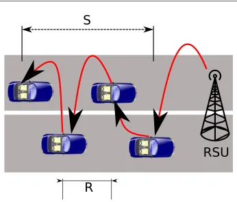
Given two nodes separated by a distance S, Pmhc(S) is the probability of having
multi-hop connectivity (mhc) or, in other words, the probability that one chain of inter-connected vehicles between the two nodes exists. This probability depends – as we show below – on the distance between the two nodes, the radio coverage and the vehicular density. Figure 2.4 shows an example of a chain of interconnected vehicles between a car and an RSU. We model the distance D between consecutive vehicles (inter-vehicle spacing) as exponentially distributed [12, 21], with parameter β, with its Probability Density Function (PDF) given by:
fD(d) =βe−βd, d≥0, (2.1)
0
500 1000 1500 2000
2500 300010 2030 4050 60 0 0.2 0.4 0.6 0.8 1 Pmhc Pmhc S (m) density (veh/km) Pmhc
(a)R= 150m
0
500 1000 1500 2000
2500 300010 2030 4050 60 0 0.2 0.4 0.6 0.8 1 Pmhc Pmhc S (m) density (veh/km) Pmhc
(b)R= 300m
0
500 1000 1500 2000
2500 3000 5 1015 2025 30 0 0.2 0.4 0.6 0.8 1 Pmhc Pmhc S (m) density (veh/km) Pmhc
(c)R= 450m
Figure 2.5: Pmhc: simulation results (cut in 90% probability).
LetRbe the wireless coverage radius. The distance between two consecutive vehicles that are part of a connected multi-hop chain of vehicles (the inter-vehicle gap is smaller than R) follows a truncated exponential distribution [35]:
fte(d) =
βe−βd
1−e−βR, 0< d < R,
0, otherwise. (2.2)
The length of a multi-hop connected chain of n+ 1 vehicles (Y) can be represented as the sum of n independent exponential truncated variables. The PDF of Y can be obtained by the method of characteristic functions [35]:
gY(y;n) = (βb) n
(n−1)!e −βy
k0
X
k=0
(−1)k
n k
(y−kR)n−1; k0R < y <(k0+ 1)R (2.3)
where k0 = 0,1,· · ·, n−1, andb= (1−e−βR).
2.3. Effectiveness of Vehicular Multi-hop Communications 21
Function (CDF) ofY evaluated atais GY(a;n) =R0agY(y;n)dy:
GY(a;n) = 1
(1−e−βR)−n k0
X
k=0
(−1)k
n k
e−βkR Q[2(k0′−k+c)Rβ,2n]. (2.4)
where Q[u, w] = P χ2(w)< u
and χ2(w) is a chi-square variable with w degrees of freedom. Since the probability P(i) of having a connected chain of i hops is given by (1−e−βR)i e−βR, the PDF and CDF of the length (L) of a connected multi-hop chain of
vehicles can be derived using the law of total probability:
fL(l) =
∞
X
i=0
P(ihops)gY(l;i) =
∞
X
i=0
(1−e−βR)ie−βRgY(l;i), (2.5)
FL(l) =PL(L≤l) =
Z l 0
fL(u)du=
∞
X
i=0
(1−e−βR)ie−βRGY(l;i). (2.6)
Based on this,Pmhc(S) is given by:
Pmhc(S) = 1−FL(S). (2.7)
Another factor that should be considered to assess the feasibility of vehicular multi-hop communications is the number of available lanes in a road. Our previous analysis is valid regardless of the number of lanes, thanks to the properties of the exponential distribution. If we consider several lanes, and in each one we model the spacing between cars by an exponential distribution, not necessarily with the same mean (the different lanes can have different car densities), the resulting space between cars in the road (independently from the number of lanes) is exponentially distributed with mean the average of the means in each lane. Therefore, we do not assume any particular number of lanes throughout the rest of the chapter, unless indicated explicitly. Note that we are approximating the car distribution assuming that there is no correlation between the lane geometry and the car distribution. This means that we disregard the spatial correlation introduced by traffic regulation and congestion. The consequences of this assumption are evaluated in the next section.
In order to validate our analysis of Pmhc, we performed a large amount of
experi-ments via simulation under different traffic conditions. The simulator5 was developed using MATLAB and it implements the scenario described in this section, namely vehicles
5The code of this simulator is available at
distributed in a one-dimensional road, travelling at a predefined and constant speed, with an exponential inter-vehicular distance and a maximum wireless radio coverage, assuming an ideal wireless technology (no packet losses nor collisions and infinite bandwidth). Al-though the simulator does not consider a real wireless model, we argue that it is enough to show the correctness of our mathematical model, as it fully implements the behavior we are modeling. Obtained results show that our mathematical analysis perfectly models the probability of having multi-hop connectivity (assuming the aforementioned simplifi-cations). Simulation and experimental results are shown in Section 2.4, where we use a more advanced simulator (OMNeT++) that does include a complete wireless model to validate our formulation of the configuration time of the ETSI SLAAC solution.
In the following, we focus on analyzing the scenarios in which unicast communications using a multi-hop vehicular network are feasible. There are three parameters that have an impact on the probability of having multi-hop connectivity between two nodes:
The distance S between the nodes. The larger this distance is, the lower is the probability of having connectivity. If we focus on the vehicle-to-Internet scenario, this value would be related to the distance between a moving vehicle and the fixed RSU, and therefore it depends on how RSUs are deployed.
The vehicular density β. The probability of having connectivity increases with the vehicular density. The density depends on the traffic conditions (i.e., the time of the day and road) and the type of road (i.e., there are roads more congested than others). Vehicles density and speed are usually correlated as well, since the minimum safety distance between vehicles depends on the speed [36].
The wireless coverage radiusR. The effective radius depends on the specific wireless access technology, the transmission power at the antenna, the antenna radiation pattern and the instantaneous channel response. The probability of having multi-hop connectivity is obviously very much affected by R, shorter values leading to lower probabilities.
2.3. Effectiveness of Vehicular Multi-hop Communications 23 10 15 20 25 30 35 40 45 50
500 1000 1500 2000 2500 3000
density (veh/km)
S (m)
Pmhc = 0.7
Pmhc = 0.8
Pmhc = 0.9
Pmhc = 0.95
(a)R= 150m
4 6 8 10 12 14 16 18 20 22
500 1000 1500 2000 2500 3000
density (veh/km)
S (m)
Pmhc = 0.7
Pmhc = 0.8
Pmhc = 0.9
Pmhc = 0.95
(b)R= 300m
2 4 6 8 10 12 14
500 1000 1500 2000 2500 3000
density (veh/km)
S (m)
Pmhc = 0.7
Pmhc = 0.8
Pmhc = 0.9
Pmhc = 0.95
(c)R= 450m
Figure 2.6: Contours for different values of Pmhc.
are the combinations of β and S that result in values of Pmhc higher than 90%. The
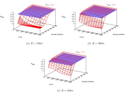
cut (intersection) of horizontal planes corresponding to probabilities of 0.7, 0.8, 0.9 and 0.95 and the 3D curve are shown in Figure 2.6. Using this figure we can find out which is the minimum vehicular density required to achieve a minimum multi-hop connectivity probability between two nodes separated by a given distance. Let’s take for example the reference value of S = 1000m. From the results in Figure 2.6, we can conclude that if the coverage radiusR is 150m, a vehicular density of approximately 35 veh/km or higher ensures that there is multi-hop connectivity in the 90% of the cases. Similarly, 15 veh/km are enough if R is 300m, and 8 veh/km for R = 450m. It is important to highlight that these densities are quite low, and that therefore are likely to be found in realistic scenarios with typical traffic conditions. We selected the following three scenarios which mostly cover a wide spectrum of potential traffic scenarios:
Urban road: high vehicular density (β = 80veh/km) and low speed (v= 50km/h).
City highway: moderate vehicular density (β = 50veh/km) and moderate speed (v= 80km/h).
0 2 4 6 8 10 12 14
0 200 400 600 800 1000 1200 1400 1600
Number of hops
S (m)
v = 120 Km/h β = 10 veh/km (simulation) v = 80 Km/h β = 20 veh/km (simulation) v = 50 Km/h β = 40 veh/km (simulation)
(a)R= 150m
0 2 4 6 8 10 12 14
0 200 400 600 800 1000 1200 1400 1600
Number of hops
S (m)
v = 120 Km/h β = 10 veh/km (simulation) v = 80 Km/h β = 20 veh/km (simulation) v = 50 Km/h β = 40 veh/km (simulation)
(b)R= 300m
0 2 4 6 8 10 12 14
0 200 400 600 800 1000 1200 1400 1600
Number of hops
S (m)
v = 120 Km/h β = 10 veh/km (simulation) v = 80 Km/h β = 20 veh/km (simulation) v = 50 Km/h β = 40 veh/km (simulation)
(c)R= 450m
Figure 2.7: Number of hops: simulation results.
As it can be observed from Figure 2.6, it is perfectly feasible to have multi-hop con-nectivity in these three scenarios for most of the potential deployments (i.e., inter-RSU distances). The probability of multi-hop connectivity is not the only parameter that should be considered when assessing the feasibility of vehicular communications, as the number of hops also plays an important role (i.e., the larger this number is, the lower are throughput and reliability). Figure 2.7 shows the average, minimum and maximum values of the number of traversed hops (only for those communications that can take place, i.e., where a multi-hop chain of vehicles exists) for the same scenarios. From these results we can also conclude that it is not efficient from a performance viewpoint to deploy RSUs which are separated by large distances, as the number of hops would get too high, impacting the performance of the communications. It should be noted that vehicles are expected to be equipped with one single wireless radio interface for multi-hop communi-cations using a self configured VANET6 and therefore the effective throughput decreases with the number of traversed wireless hops in the VANET.
6It is also very likely that in the future, cars are equipped with a dedicated interface for safety-related
2.4. Analytical Characterization of the ETSI SLAAC’s Performance 25
2.4
Analytical Characterization of the ETSI SLAAC’s
Per-formance
The main purpose of an IP address auto-configuration protocol is to provide each node with a valid IP address as soon as possible. In the followings we derive an analytical expression of the time required by the ETSI SLAAC solution to configure an address. The address configuration time (Tconf) is the time elapsed since a vehicle enters a new
geographical area (therefore loosing the connectivity to the old RSU) till the moment in which it can start using the newly configured global IPv6 address. This time depends on several factors, such as the shape and size of the areas, the configuration of the RSUs and ARs, etc. We consider that the time between two consecutive RAs sent by an RSU (or an AR in case the RSU is working in bridge mode) follows a uniform distribution between a minimum value (MinRtrAdvInterval) and a maximum value (MaxRtrAdvInterval), which we refer to as Rm and RM respectively [38].
We use the following additional terminology. LetDRSU be the distance between two
adjacent RSUs,R the wireless communication range, β the vehicular density, and v the speed of the vehicles7.
In order to obtain a mathematical expression for Tconf, we first calculate the mean
length of a chain of vehicles. Based on that, we are able to find out which is – on average – the length of the gap between the multi-hop chain of vehicles from the unconfigured vehicle and the RSU wireless coverage area ¯Dgap (see Figure 2.8).
The average distance between two consecutive vehicles can be calculated using Eq. (2.2), and it is given by:
¯
D=
Z ∞
−∞
d fte(d)dd=
1 +βR−eβR
β(1−eβR) . (2.8)
The average length of a chain composed byi+ 1 vehicles is:
¯
Lchain(i+ 1) =iD.¯ (2.9)
As already seen in Section 2.3, the probability of having a connected chain composed exactly by i+ 1 vehicles is given by: (1−e−βR)i e−βR. From this, we can calculate the average length of a multi-hop connected chain of vehicles:
¯
Lchain=
Z ∞
0
l fL(l)dl=
∞
X
i=0
(1−e−βR)ie−βRL¯chain(i+ 1). (2.10)
7We consider the speed of all vehicles fixed and constant for simplicity of the model. Simulation results
D
GVL area n-1 GVL area n
RSU 2
⩽R
⩽R
>R
D⩽R
RSU
R
Lchain Dgap
Figure 2.8: ETSI TC ITS IPv6 address configuration
Therefore, the average gap length is given by:
¯
Dgap=
DRSU
2 −R−L¯chain. (2.11) Let Tunsol
RA be the time elapsed since a vehicle changes area until the RSU sends the
next unsolicited RA. The average value of this time is given by [39]:
¯
TRAunsol= R
2
M +RMRm+R2m
3(RM +Rm)
. (2.12)
Now we can calculate the average ETSI SLAAC address configuration time ( ¯Tconf),
by simply considering the two possible configuration situations: i) there is on average multi-hop connectivity between the unconfigured vehicle and the RSU (i.e., ¯Dgap ≤ 0),
and therefore vehicles only need to wait ¯TRAunsol for the next unsolicited RA sent by the RSU;ii)there is on average no chain of connected vehicles between the unconfigured node and the RSU:
¯
Tconf =
¯
TRAunsol, D¯gap≤0,
¯
Dgap
v + ¯TRAunsol, D¯gap>0.
(2.13)
In order to validate the accuracy of our model and assess the performance of our solu-tion, we performed the following experiments. We evaluated the configuration time ¯Tconf
2.4. Analytical Characterization of the ETSI SLAAC’s Performance 27 0 2 4 6 8 10 12
0 5 10 15 20
Tconf
(s)
TRA (Rm=0.75 TRA,RM=1.25 TRA) DRSU = 2500m (analysis)
DRSU = 2000m (analysis) DRSU = 1750m (analysis) DRSU = 1500m (analysis)
DRSU = 2500m (simulation) DRSU = 2000m (simulation) DRSU = 1750m (simulation) DRSU = 1500m (simulation)
(a)R= 150m
Figure 2.9: ETSI SLAAC configuration time (analysis and simulation) for the Urban scenario. 0 2 4 6 8 10 12 14
0 5 10 15 20
Tconf
(s)
TRA (Rm=0.75 TRA,RM=1.25 TRA) DRSU = 4000m (analysis)
DRSU = 3000m (analysis) DRSU = 2500m (analysis) DRSU = 2000m (analysis)
DRSU = 4000m (simulation) DRSU = 3000m (simulation) DRSU = 2500m (simulation) DRSU = 2000m (simulation)
(a)R= 150m
0 2 4 6 8 10 12
0 5 10 15 20
Tconf
(s)
TRA (Rm=0.75 TRA,RM=1.25 TRA) DRSU = 4000m (analysis)
DRSU = 3000m (analysis) DRSU = 2500m (analysis) DRSU = 2000m (analysis)
DRSU = 4000m (simulation) DRSU = 3000m (simulation) DRSU = 2500m (simulation) DRSU = 2000m (simulation)
(b)R= 300m
Figure 2.10: ETSI SLAAC configuration time (analysis and simulation) for the City highway scenario.
the radio wireless coverage of each node (R) and the average time between unsolicited RAs (TRA). The same MATLAB-based simulator that was used in Section 2.3 to assess
the effectiveness of multi-hop unicast communications in a vehicular scenario is used in these experiments. Therefore, an ideal wireless technology is assumed. In the next section we also perform an experimental evaluation based on a more complex model, and using the OMNeT++ simulator, that allows us to assess the correctness of the simplifications assumed in our mathematical model of the ETSI SLAAC configuration time, and also to derive some configuration guidelines.
0 2 4 6 8 10 12 14 16 18 20
0 5 10 15 20
Tconf
(s)
TRA (Rm=0.75 TRA,RM=1.25 TRA) DRSU = 4000m (analysis)
DRSU = 3000m (analysis) DRSU = 2500m (analysis) DRSU = 2000m (analysis)
DRSU = 4000m (simulation) DRSU = 3000m (simulation) DRSU = 2500m (simulation) DRSU = 2000m (simulation)
(a)R= 150m
0 2 4 6 8 10 12
0 5 10 15 20
Tconf
(s)
TRA (Rm=0.75 TRA,RM=1.25 TRA) DRSU = 4000m (analysis)
DRSU = 3000m (analysis) DRSU = 2500m (analysis) DRSU = 2000m (analysis)
DRSU = 4000m (simulation) DRSU = 3000m (simulation) DRSU = 2500m (simulation) DRSU = 2000m (simulation)
(b)R= 300m
Figure 2.11: ETSI SLAAC configuration time (analysis and simulation) for the Motorway scenario.
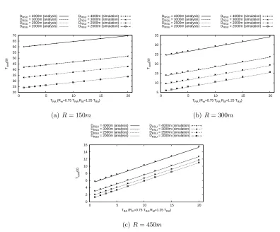
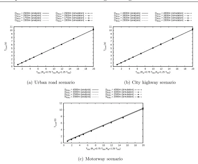
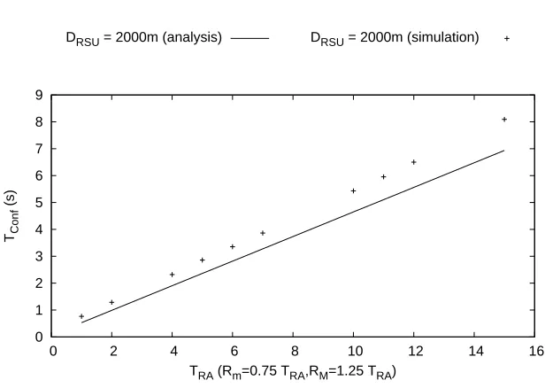
shown in Figures 2.9–2.11, in which the values calculated from our analysis are also depicted. We make use of the same three scenarios that we used in Section 2.3: urban, city highway and motorway, and we also represent the results for different deployment scenarios (characterized by DRSU and TRA8). Note that the range of the average time
between Router Advertisements sent by the RSU (TRA) depends on the traffic conditions
scenario. This is so because the maximum value that could be configured in a real scenario should allow for vehicles to always have at least one configuration opportunity before changing area, and that means that TRA has to be low enough to allow that a
vehicle would be configured – in the worst possible case – when it is within one single hop of the RSU (i.e., the minimum time required by a vehicle to cross the whole coverage area of the RSU should not be higher thanRM). Note that in Figure 2.9 (urban scenario) we
only show the case R = 150m, as the results for R = 300m and R = 450m are almost exactly the same (the actual difference is negligible). Similarly, for the city highway and motorway scenarios (Figures 2.10 and 2.11) we also skip depicting the results for
R = 450m, as they are equivalent to those for R = 300m. This is due to the fact that in the studied scenarios, the vehicular density proves to be enough to ensure multi-hop connectivity in most of the situations, and therefore ¯Tconf ≃T¯RAunsol. These are reasonable
scenarios in terms of vehicular density, and they are actually the ones in which it makes sense to enable Internet hop communications, as the probability of having multi-hop connectivity to the RSU is high enough, and the configuration time is short enough to support classical IP communications (e.g., infotainment, non-safety). We also analyze later in this chapter sparser scenarios, in which the vehicular density is much lower.
From Figures 2.9–2.11 we can derive different conclusions. First of all, results show that our mathematical analysis perfectly matches our model of the ETSI SLAAC so-lution configuration time, assuming the simplifications that we have described in this
8R
2.4. Analytical Characterization of the ETSI SLAAC’s Performance 29
section, namely: constant and homogeneous speed, perfect collision-free wireless medium, exponential inter-vehicle spacing. Another important conclusion is that in most of the scenarios, the IP address auto-configuration time can be kept very low by properly con-figuring the time interval between Router Advertisements, without using too aggressive values. Besides, in these scenarios the value of the wireless coverage technology (R) – which depends on the particular access technology, transceiver performance, antenna, and channel conditions – and the distance DRSU between deployed RSUs, do not seem
to have a noticeable impact on the resulting configuration time. Nevertheless, we should not forget that shorter values of R combined with larger values of DRSU would lead to
longer multi-hop paths, in terms of number of traversed nodes, and therefore lower ef-fective bandwidths. Only for R = 150m and in the motorway scenario (this behavior starts to be noticeable in the city highway scenario), the distance between RSUs has an impact on the configuration time, as the chances to have multi-hop connectivity between an unconfigured node that just enters into an area and the RSU decrease with the dis-tance between them (DRSU). In the motorway scenario, as we could anticipate from the
results shown in Figure 2.4, configuration times are higher – though still reasonable – as the probability of having a multi-hop chain between the unconfigured node and the RSU is lower.
A simple qualitative evaluation of the ETSI SLAAC performance can be done by comparingTconf with the estimated permanency time of a vehicle within a geographical
area. For the sake of the example, let’s consider a non-extreme case, as the one of an area with a length (DRSU) of 2000m and a wireless radio technology with R = 300m, in the
city highway scenario (average speed of 80 km/h). In this scenario, a vehicle spends about 90 seconds in the area. By choosing values of TRA smaller than 10 seconds, the ETSI
SLAAC solution guarantees that vehicles can have Internet connectivity for more than 80 seconds, as ¯Tconf is approximately 5 seconds. However, it is important to highlight that
the configuration parameters, such as the size and shape of the geographical areas, should be chosen also taking into account the expected traffic conditions. For example, in sparse scenarios, areas should be longer than the physical radio coverage R, while in dense scenarios the opposite case is more appropriate. We derive some simple configuration guidelines in Section 2.5.
In addition to these experiments, we performed some simulations to validate the cor-rectness of our mathematical analysis also in scenarios in which the vehicular density is not high enough to have multi-hop connectivity during most of the time (β = 10 veh/km,
v = 100 km/h). Examples of this scenario are city highways and motorways at night, or secondary roads. Results (see Figure 2.12) show that our mathematical analysis also matches the simulation results in sparse scenarios (i.e., with low values of Pmhc).
20 25 30 35 40 45 50 55 60 65 70
0 5 10 15 20
Tconf
(s)
TRA (Rm=0.75 TRA,RM=1.25 TRA) DRSU = 4000m (analysis)
DRSU = 3000m (analysis) DRSU = 2500m (analysis) DRSU = 2000m (analysis)
DRSU = 4000m (simulation) DRSU = 3000m (simulation) DRSU = 2500m (simulation) DRSU = 2000m (simulation)
(a)R= 150m
5 10 15 20 25 30 35
0 5 10 15 20
Tconf
(s)
TRA (Rm=0.75 TRA,RM=1.25 TRA) DRSU = 4000m (analysis)
DRSU = 3000m (analysis) DRSU = 2500m (analysis) DRSU = 2000m (analysis)
DRSU = 4000m (simulation) DRSU = 3000m (simulation) DRSU = 2500m (simulation) DRSU = 2000m (simulation)
(b)R= 300m
0 2 4 6 8 10 12 14 16
0 5 10 15 20
Tconf
(s)
TRA (Rm=0.75 TRA,RM=1.25 TRA) DRSU = 4000m (analysis)
DRSU = 3000m (analysis) DRSU = 2500m (analysis) DRSU = 2000m (analysis)
DRSU = 4000m (simulation) DRSU = 3000m (simulation) DRSU = 2500m (simulation) DRSU = 2000m (simulation)
(c)R= 450m
Figure 2.12: ETSI SLAAC configuration time (analysis and simulation) for the Sparse scenario.
address, because in many cases the vehicle is not able to receive an RA until it is within the 1-hop coverage of the RSU. This also means that during a considerable amount of the time a vehicle is visiting a geographical area, it does not benefit from having connec-tivity with the RSU. It can also be observed that in this kind of scenario R has a bigger impact on the performance, as higher values of R lead to higher multi-hop connectivity probabilities.
2.5
Experimental Evaluation and Configuration guidelines
In this section we take a step further and experimentally evaluate the performance of the ETSI SLAAC solution – in terms of address configuration time – eliminating some of the simplifications assumed in the previous section. The goal is to assess if our mathematical model is still good enough when we use a simulation model that better replicates a real environment.
2.5. Experimental Evaluation and Configuration guidelines 31 0 1 2 3 4 5 6 7 8 9 10 11
0 2 4 6 8 10 12 14 16 18 20 TConf
(s)
TRA (Rm=0.75 TRA,RM=1.25 TRA) DRSU = 2500m (analysis)
DRSU = 2000m (analysis) DRSU = 1750m (analysis) DRSU = 1500m (analysis)
DRSU = 2500m (simulation) DRSU = 2000m (simulation) DRSU = 1750m (simulation) DRSU = 1500m (simulation)
(a) Urban road scenario
0 1 2 3 4 5 6 7 8 9 10 11
0 2 4 6 8 10 12 14 16 18 20 TConf
(s)
TRA (Rm=0.75 TRA,RM=1.25 TRA) DRSU = 4000m (analysis)
DRSU = 3000m (analysis) DRSU = 2500m (analysis) DRSU = 2000m (analysis)
DRSU = 4000m (simulation) DRSU = 3000m (simulation) DRSU = 2500m (simulation) DRSU = 2000m (simulation)
(b) City highway scenario
0 2 4 6 8 10 12
0 2 4 6 8 10 12 14 16 18 20 TConf
(s)
TRA (Rm=0.75 TRA,RM=1.25 TRA) DRSU = 4000m (analysis)
DRSU = 3000m (analysis) DRSU = 2500m (analysis) DRSU = 2000m (analysis)
DRSU = 4000m (simulation) DRSU = 3000m (simulation) DRSU = 2500m (simulation) DRSU = 2000m (simulation)
(c) Motorway scenario
Figure 2.13: ETSI SLAAC configuration time (analysis and simulation with OMNeT++).
IEEE 802.11. In order to do so, we implemented the ETSI SLAAC solution9using Mixim. Mixim10 is a framework for wireless ad hoc network for the OMNeT++ simulator11. It
provides the 802.11 MAC layer and many physical layer models (including the widely accepted path-loss, shadowing and large and small-scale fading models [40] [41] [42]). The simulation scenario consists of a road segment where vehicles travel within a homogeneous flow. Vehicles’