Abstract : Mesquite ( Prosopis ) had been imported from its original home in North and South America, which is ranked as a desert plants, that bear all environmental conditions, it had been planted in the Tokar Delta, which is located in the Red Sea State in Sudan, as a belt against desert encroachment from which the city is suffering annually, but after few years These trees deployed in the Delta and became a new risk to the agricultural lands and the banks of Khor Baraka producing another problem. Now mesquite covers more than half of the delta's area causing negative impact on all of the agricultural lands, surface, ground water and irrigation channels. This paper is intended to assess the impact of the mesquite on the Tokar Delta and the impact of efforts to control the spread of mesquite trees over 30 years. Also to provide guidelines for the management and control of mesquite trees, using the capabilities of remote sensing and geographic information systems in producing layers of maps and attributes, showing the spatial extent of these trees in the Delta over the study periods of time, and conduct analysis to support decision makers to solve this serious problem.
Keywords: Impact, Mesquite, Area, Delta Tokar, GIS
I.
INTRODUCTION
During the Colonial times Tokar delta was great source of wealth through the extensive production of cotton, but since then land usage has declined to less than 70,000 hectares. It has been estimated that more than 1400 hectares of the delta can no longer be cultivated because of mesquite infestation [3]. Mesquite species now invade greater part of the Delta area and create risk to the environment and the population. This paper is an attempt to assess, map and analyze mesquite risk in Tokar Delta aiming to have better understanding to the invasion dynamics and provide guidance for management plans.
Scale crop production has also been negatively impacted over the last ten years by the rapid spread of Mesquite trees that has significantly reduced the area of agricultural land disrupted irrigation channels and provided shelter for pests, particularly in the Delta areas and South Tokar. This has led to increased, sharecropping by farmers. The lack of sufficient agricultural extension and appropriate policies and strategies, inadequate pest control and inappropriate water harvesting systems has further contributed to the inability to grow crops and attain food security in the state. Mesquite can control the leaf water evaporation and survive in any condition regardless of the weather. This is because water efficiency is more than those of native plants [2].Therefore Data on the distribution of mesquite plants, captured at the correct scale and accuracy, is critical for predicting future spread and devising appropriate management plans [9,10].
II.
MATERIALS
AND
METHODS
II.1 Study Area
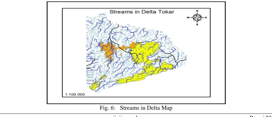
Tokar Delta is located in the southern part of the Sudanese coastal plain. It extends between latitudes 18° 00' and 18° 45' N and longitudes 37° 30' and 38° 05' E covering an area of approximately 1450 square kilometer. The delta has been formed by Khor Baraka which is an intermittent stream originates in the higher lands of Eritrea and Sudan. It flows northeast across the area and terminates in a wide delta which starts from Shidden Rock and ends at the Red Sea (Fig. 1).
Fig. 1: The Study Area
II.2 The Data
- Satellite image was obtained from the Sudanese Survey Institution, of high accuracy to enable distinguishing between areas clearly and also Sudan map with scale 1: 5000.
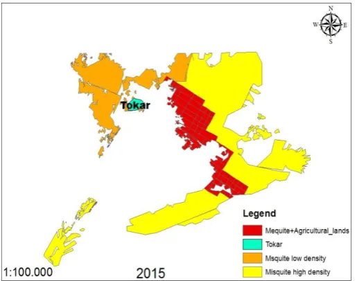
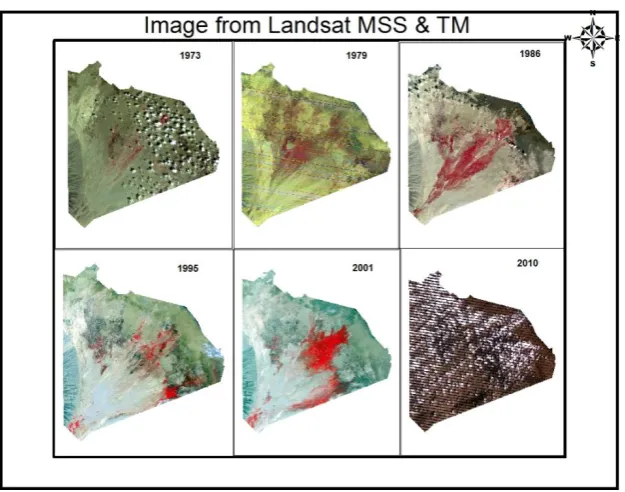
- Map of agricultural lands of the Delta Tokar from Delta project management in 2015 as in Fig. 2 - Landsat MSS & TM Satellite images (Fig. 3) have been downloaded from http://earthexplorer.usgs.gov
Fig. 3: Images before analysis
II.3 Detecting of mesquite trees
The remote sensing method is very useful to detect the invasion route of mesquite trees in wide area. Since plants leaf absorbs red light energy, and reflect near-infrared (NIR) light energy of sunlight. Various image processing techniques have been implemented to the images using ERDAS Imagine 9.1, and ArcGIS10.2 software. These were including; image subset, spectral test, enhancement and classification. Normalized Difference Vegetation Index (NDVI) was one of the most successful of many attempts to simply and quickly identify vegetated areas and their "condition," and it remains the most well-known and used index to detect live green plant canopies in multispectral remote sensing [13].
III.
RESULT
AND
DISCUSSION
Normalized Difference Vegetation Index (NDVI) map calculated from Landsat data (where, green-colors shows the satellite extraction of mesquite tree pixels). Fig. 4 shows Mesquite Area in Tokar Delta from the period of 1973 to 2010. In addition the agriculture map was used to indicate the spread of mesquite in 2015.
Fig. 5: Mesquite Area in Tokar Delta 1973 _ 2015.
The results (in Fig. 5) showed that very few prevalent mesquites in the time between 1973-1979 ratios can be controlled. A high percentage in prolife ratio was shown in 1986 while in the later period the invasion was limited, then it is start to increase in 2001. After that the proportion of removal operations conducted in the period between 2001 and 2010, there was some control measures applied to reduce mesquite expansion in the Delta such as clear cutting and eradication which also has impact in. In the last five years, Mesquite spread again extensively and represented the highest rate over the past years and evaded a very large part of the Delta and the entrances to Khor Baraka in the form of a dense forest, the prevalence rate is estimated to more than (100%) there were more bare lands with good moisture in the delta area which gave chance for rapid spread of mesquite. In addition more studies that are related to the problem of published papers on the Internet and the National Forestry Commission pasture section was discussed
III.1 Operations of Mesquite Removal
In 2002, Oxfam made a clean of 13 thousand acres of mesquite trees and hand-ax under the food-work program. In 2005 the most important steps were taken to ratify the removal of 100 thousand acres discount on the development of the Eastern States of the Federal Ministry of Finance and the Ministry of Agriculture and Forestry of the Federal budget (pilot projects), has been one hundred thousand acres divided into five phases consisting of 20 thousand acres [12].
III.2 The impact of Mesquite
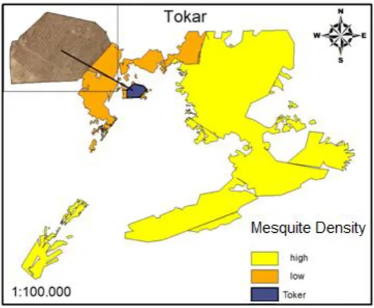
Fig 7: City's site with mesquite Map.
III.2.2 Impact on pasture
Mesquite produces profusely fruits and is palatable to all animals as it is feed excellent rich in protein (13%), this is a high rate compared to other fodder in the use of animal food on the ointment [5].
III.2.3 The impact on agricultural lands:
The biggest risk for the invasion of mesquite tree in the delta on agricultural lands (see Fig. 8) where Mesquite occupies large part especially from the north-eastern and southern entrances to the Khor Baraka in the form of dense forests represent a present by danger and by up to more than about 50% compared with agricultural land available in Central Delta [1]
.
III.2.4 Impact on groundwater:
The geoelectric investigation has shown that the freshwater in the aquifer overlies saline or brackish water. The freshwater-bearing aquifer has an area of 200 square kilometer rep-resenting about 14% of the total area of the delta [2].
Very significant in the area covered by the natural vegetation, which mainly consists of the mesquite trees (Prosopis chilensis) forming dense and multi-aged forests in the lower delta and the upper delta. The total annual evapotranspiration of mesquite trees species and other vegetation types related to annual evaporation from open-water surfaces values per unit land area are revealed in, evapotranspiration is re-ported per unit land area occupied by each vegetation type, which includes the total water used by the vegetation including groundwater and surface water sources.
The surface area of the freshwater aquifer which is covered by mesquite forests is about 45 square kilometer. Mesquite uses a combination of surface water, groundwater and deep vadose-zone sources (1 to 10 meters) depending on the availability of each source throughout the season [8]. Hence a total volume of groundwater discharged from the freshwater aquifer due to evapotranspiration is estimated to be 21.8 x10⁶ m3/y4
IV.
CONCLUSION
Geographic Information Systems (GIS), coupled with the remote sensing can identify and assess the distribution of Mesquite in Tokar Delta. As the results documented, most of the study area showed there is clear mesquite invasion and risk in 2015. The result can be useful and can provide guidelines for management and control the spread of Mesquite.
REFERENCES
[1] Abdulmagid, T. D. An approach towards mesquite management in Kassala State, 2008, PhD Thesis, University of Khartoum.
[2] Babiker, E. M. Elzein, M. Groundwater Resource Potential and Water Balance Components in Tokar Delta- Sudan.
[3] CBS, Central Bureau of Statistics-The Republic of Sudan, 2008 Census.Eastern , Sudan..
[4] Dafa. A. Scientific and experimental methods to get rid of mesquite tree, 1996, Ministry of Agriculture and Livestock.
[5] Eltayeb, A. (2001). Mesquites reality and challenge ,research station new halfa, Agricultural Research corporation.
[6] Climate,. www.climate-charts.com, 2013, Tokar, Sudan. Retrieved 10.12.2013
[7] Hoshino, B., Karamalla, A., Mohamed, A., Manayeva, K., Yoda, K., Suliman, M., Mohamed, E., NAWATA, H., and Yasuda, H. Evaluating the Invasion Strategic of Mesquite (Prosopis juliflora) in Eastern Sudan Using Remotely Sensed Technique. Journal of Arid Land Studies, 2012, 22(1), 1-4
[8] Lite, S. J. San Perdo River riparian vegetation across water availability and flood disturbance gradients, Ph.D. dissertation. Tempe, Arizona State Univer. pp.166.
[9] Mack, R. N. Assessing biotic invasions in time and space: the second imperative. In: H. A. Mooney, R. N. Mack, J. A. McNeely, L. E. Neville, P. J. Schei, and J. K. Waage. Invasive alien species: A new synthesis. London, United Kingdom: Island Press, 2005, p. 179–208.
[10] Mullerov, J., P. Pysek, V. Jarosik, and Pergel, J. 2005. Aerial photographs as a tool for assessing the regional dynamics of the invasive plant species Heracleium mantegazzianum. Journal of Applied Ecology, 2005, 42:1042–1053.
[11] Omer A.M, .(1995). The Political Ecology of Subsistence Crisis in the Red Sea Hills, Sudan.Ph.D. Thesis .University of Bergen, Norway.
[12] Osman, O. A. Study on the expansion of mesquite trees in Delta Toker and its negative impacts. http://www.sudanile.com/index.php?option=com_content&view=article&id=11743:2010-03-08- 19-40 15&catid=51:aaaaaa&Itemid=55,2010.