FORERUNNERS OF URBANISM
A comparative study of settlement organisation in Western Veneto
and South Etruria from the Middle Bronze Age to the end of the
Final Bronze Age.
by
Mâria del Carmen VIDA NAVARRO
Ph.D. Thesis
ProQuest Number: 10017682
All rights reserved
INFORMATION TO ALL USERS
The quality of this reproduction is dependent upon the quality of the copy submitted.
In the unlikely event that the author did not send a complete manuscript and there are missing pages, these will be noted. Also, if material had to be removed,
a note will indicate the deletion.
uest.
ProQuest 10017682
Published by ProQuest LLC(2016). Copyright of the Dissertation is held by the Author.
All rights reserved.
This work is protected against unauthorized copying under Title 17, United States Code. Microform Edition © ProQuest LLC.
ProQuest LLC
789 East Eisenhower Parkway P.O. Box 1346
ABSTRACT
The Ph.D studies the settlement trends of two areas in Italy -Western Veneto and South Etruria- for which there is clear evidence of increasing complexity during the Bronze Age. The developments which took place in both areas are compared to monitor wider social and historical issues, namely the possible factors and causes behind the processes leading to settlement nucléation and the later emergence of urban forms in Italy. The two areas provide an outstanding opportunity for this, because their trajectories appear similar yet diverge in the final stages: Southern Etruria to undertake a leap in complexity which led to the emergence of its Iron Age protourban groups; Western Veneto to face a halt and apparent reversal of trends, and the virtual collapse of the area as a focus for settlement. Both areas have also been the object of field survey campaigns, which have contributed to a better knowledge of the overall settlement distribution of the regions. The approach adopted is a novel one in that it oversteps local and regional boundaries to compare the various trends affecting the two regions, in so far as the data allows it, on the same footing, as a way of assessing the extent of their impact on settlement.
TABLE OF CONTENTS
Contents page
Title Page 1
Abstract 2
Table of Contents 3
Acknowledgements 7
Chapter 1 : Aims and Methodology 11
Chapter 2: Terminology 32
Chapter 3: The Historical Perspective 40
Chapter 4: Environmental Relationships 59
Chapter 5: The Time Dimension: Traditional Chronologies and Continuity 100
Chapter 6: Chronological Analysis 133
Chapter 7: Subsistence and Technology 163
Chapter 8: Social Interactions 194
Chapter 9: Interpretation 222
Appendix I: Plant Ecology Information 237
Appendix II: Pottery and Bronze Typologies 243
Bibliography 363
List of tables page
Table 1: Summary Chronological Table for Northern Italy 52 Table 2: Summary Chronological Table for Central Italy 53
Table 3: European climatic sequence 64
Table 4: Chronological spans for sites in Western Veneto 120 Table 5: Chronological spans for sites in South Etruria 122
Table 6: Radiocarbon dates from Western Veneto 134
Table 7: Radiocarbon dates from South Etruria 139
List of illustrations page
Fig. 1: Location of study areas in Italy: Etruria’s physical landscape 17 Fig. 2: Location of study areas in Italy: Veneto’s physical landscape 18
Fig. 3: Sites in South Etruria 24
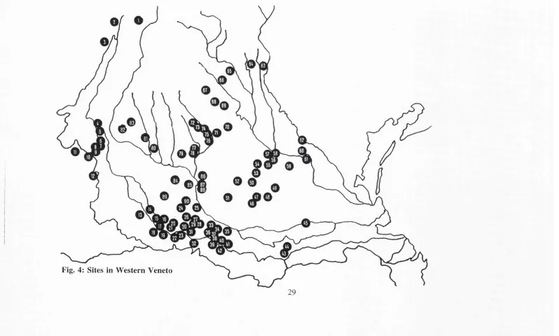
Fig. 4: Sites in Western Veneto 29
Fig. 5: Environmental Relationships Model 61
Fig. 6: Diagram of changes to timberline altitude 69
Fig. 7: Variations from average levels 71
Fig. 8: Pollen core from Fimon 81
Fig. 9: Pollen core from Arqua Petrarca 81
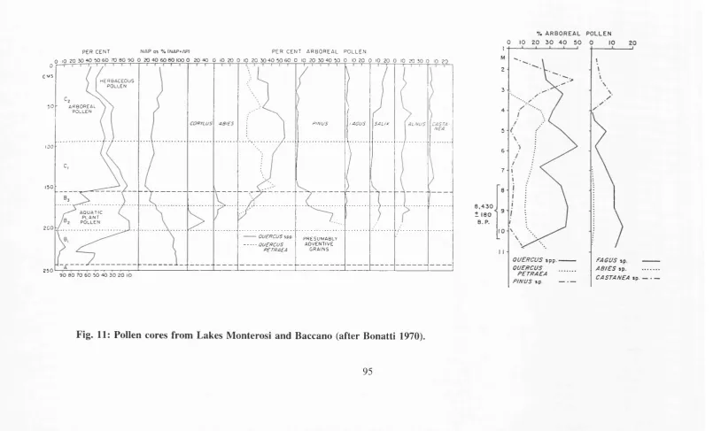
Fig. 10: Changes to coastline and fluvial systems in Western Veneto 90 Fig. 11 : Pollen profiles from Lakes Monterosi and Baccano 95
Fig. 12: Differential Time Scales Model 104
Fig. 13: Settlement Continuity in South Etruria 130
Fig. 14: Settlement Continuity in Western Veneto 130
Fig. 15: Dispersion Diagrams: Western Veneto 153
Fig. 16: Dispersion Diagrams: South Etruria 154
Fig. 17: Dispersion Diagrams: Mezzano Lake 155
Fig. n , 12 B: Decorative motifs characteristic of the MB3b in Central Italy 310 Fig. n , 13: Decorative motifs characteristic of the MB3b in Central Italy 311 Fig.
n
Fig.
n
Fig.n
Fig. n Fig. II Fig.n
Fig. n Fig.n
14: Decorative motifs characteristic of the MB3b in Central Italy 312 15: Bronze types characteristic of the MB3 in Central Italy 313 16: Pottery types characteristic of the LB A in Central Italy 314 17: Pottery types characteristic of the LB A in Central Italy 315 18: Pottery types characteristic of the LB A in Central Italy 316 19: Bronze types characteristic of the LB A in Central Italy 317 20: Pottery and bronze types characteristic of the FBAl in Central Italy 318 21 A: Bronze types characteristic of the FBA2 in Central Italy 319
21 B: Bronze types characteristic of the FBA2/3 In Central Italy 319 22: Pottery types characteristic of the FB3 in Central Italy 320 23: Bronze types characteristic of the FB3 in Central Italy 321 24: Bronze types characteristic of the FB3 in Central Italy 322 25: Pottery and bronze types characteristic of the M Bl in N. Italy 323 26: Pottery and bronze types characteristic of the MB 1 in N. Italy 324 27: Pottery characteristic of the M Bl in Northern Italy 325 28: Pottery characteristic of the M Bl in Northern Italy 326 29: Pottery and bronze types characteristic of the MB 1/2 in N. Italy 327 30: Pottery types characteristic of the MB 1/2 in Northern Italy 328 31: Pottery types characteristic of the MB 1/2 in Northern Italy 329 32: Pottery and bronze types characteristic of the MB2 in Northern Italy 330 33: Pottery types characteristic of the MB2 in Northern Italy 331 34: Pottery types characteristic of the MB2 in Northern Italy 332 35: Bronze types characteristic of the MB2/MB3a in Northern Italy 332 36: Pottery types characteristic of the MB2/MB3a in Northern Italy 334 37: Pottery and bronze types characteristic of the MB3a in N. Italy 335 38: Pottery and bronze types characteristic of the MB3a/MB3b in N. Italy 336 39: Pottery and bronze types characteristic of the MB3b in N. Italy 337 40: Pottery types characteristic of the MB3b in Northern Italy 338 41: Pottery types characteristic of the MB3b/LBAl in Northern Italy 339 42: Pottery and bronze types characteristic of the LBAl in Northern Italy 340 Fig. II, 22: Pottery
ACKNOWLEDGEMENTS
It is difficult to list down everyone who has provided help, assistance or simply encouragement over the research and writing of my Ph.D., but my greatest debt of gratitude remains with my parents and with my family both in Spain and here. I always had not just their support, but more incredibly, their interest at times when research became more monotonous. They have also been excellent at teaching me not to take certain things too seriously (specially the pots!!!).
I am also particularly indebted to my two supervisors. Dr. Ruth Whitehouse and Prof. Roy Hodson. Ruth has been a very inspiring figure throughout my university years, and I owe to her countless opportunities: her support was undiminished even during difficult professional situations. I think this Ph.D. is, together with others written under her supervision, a tribute to her dedication to foster research in Italian archaeology in this country and abroad.
There were many people who helped me, either by discussing ideas, reading various parts of the thesis, or facilitating information. Among this I would like to mention Dott. Armando De Guio from the Istituto di Archeologia dell’Universita di Padova, for many intense and interesting discussions, access to departmental libraries and unpublished information, and for putting up with requests for innumerable photocopies; Dotssa. Anna Maria Bietti Sestieri from the Soprintendenza di Roma, Dottssa. Nicoletta Martinelli from the Istituto Italiano di Dendrocronologia, Dr. Simon Stoddart from Bristol University, Mark Pluciennik. To Caroline I am grateful for her advice with some of the statistical questions.
My research would have been impossible without financial support from the following entities:
British Academy Studentship (Fees only)
Special gratitude goes also to the now defunct Dept, of Mediterranean Studies QMW and its staff, and to the ACCORDIA Centre, for all the help to attend Conferences, their general support and interest, and above all for having taught me as an undergraduate.
"I could tell you how many steps make up the streets rising like
stairways, and the degree o f the arcades curves, and what kind
o f zinc scales cover the roofs; but I already know this w ould be
the same as telling you nothing. The city does not consist o f this,
but o f relationships between the measurement o f its space and
the events o f its p a s t”.
”Beware o f saying to them that sometimes different cities follow
one another on the same site and under the same name, born
and dying without knowing one another, without communication
among themselves. A t times even the names o f the inhabitants
remain the same and their voices' accent, and also the features
o f the faces; but the gods who live beneath names and above
places have gone off without a w ord and outsiders have settled in
their p la c e ”.
Italo Calvino (excerpts from Le città invisibili)
Chapter 1: AIMS AND METHODOLOGY
The emergence of urban forms has always been a major topic of interest and indeed a popular one. Words as suggestive as civilisation, the Orient, a palace-city, the Mediterranean and the like are conjured up in people’s imagination from the mist of the dark beginnings of what is now the most characteristic form of modem human settlement. Until recently, however, not much attention had been paid to the beginnings but rather to the periods of greater splendour: a general tendency towards settlement nucléation in the Mediterranean at the end of the second millennium B.C. was noted and "universal" agents for its existence and grandeur were sought (for a discussion of the trend see Bietti Sestieri 1984: 57). Nevertheless, despite the universal ring and appeal of the topic, it is a naive and simplistic position to see the cities which emerged from this mist in the Mediterranean during the Iron Age as units and reflections of a single reality: urbanism and settlement nucléation are incredibly complex phenomena affected in their very core by the particular characteristics and make up of lands and populations. An initial premise in settlement studies is, thus, that the way in which men and women spread (or gather) across this earth is a direct reflection of more intangible realities such as economic activity or subsistence basis, social parameters of behaviour, the environment, ideologies, and/or different political events. It is only in the understanding of settlement genesis in any specific area that one can hope to find the causes which triggered it in that particular place, time, and form. It is only, too, after having done this, that we will be in a position to detect and understand the common issues, if such there are, which are at the root of the choice for settlement nucléation elsewhere.
1. Aims
To attempt the study of early Italian urbanism is a particularly arduous task. All evidence seems to indicate that the richness of Italian cultural manifestations was already a fact in prehistory. Besides, as it shall be seen later, the history of research in the topic is responsible for many of the problems which the subject currently faces. Whilst the complexity of settlement analysis is not limited to prehistory, it is there, nevertheless, where it appears aggravated by an even lesser knowledge of the factors involved. In tackling the problem of early urbanism in Italy, this has been a major concern: to provide
a real time perspective of the complexity of the developments which fully manifest themselves as urban in the first millennium B.C. so as to investigate the depth of the urban achievement. As the title of this work implies, its purpose is to look and study the period which preceded the full development of urbanism, in an attempt to provide a hitherto lacking background to the crystallisation of early Italian urban forms. We, thus, propose to study settlement dynamics and urban formation in the context of the Late Bronze Age.
The dawn of history, in its disciplinary sense, is marked by the many more or less legendary accounts of and references to the founding of cities by different figures and their followers (Pilemene or Antenore for Padua, Romulus for Rome), by groups of colonists (as in the founding of the towns of Megara, or Syracuse), and by expeditions of people running away from war, hunger or disasters (as were the Lydians under Tyrrhenus, mentioned by Herodotus). The still deeply instilled tendency to regard these accounts as a point of departure for research is, perhaps, to be blamed for centring the attention of researchers in the Iron Age period (e.g. Hencken 1968; Ridgway and Ridgway 1979; Pallottino 1991: 40-43). Thus, by comparison with the Bronze Age, the Iron Age has been the focus of much research concerning settlement nucléation (e.g. among others Di Gennaro 1982; Guidi 1985). In equivalent terms in settlement studies, the period of protourban formation (9th-7th centuries in traditional chronologies) has been the subject of intense attention (the Villanovans of Central Italy are the clearest example), whereas the period preceding it has remained in an obscurity which some have polemically termed as a Dark Age (Spivey & Stoddart 1990; James et al. 1991). Fortunately this trend seems to be receding. The reasons for this gap in the research of settlement nucléation are many and very complex, and linked to the historical development of archaeology as a discipline in Italy. A further aspect to be taken into account is the "unfortunate" positioning of the period in the time scale: the Late and Final Bronze Age are periods falling in the traditional frontier line between Prehistory and History, which might have caused a sort of uneasiness and reluctance to tackle it in both prehistorians and historians. The term "protohistory" does not solve the problem either, and the period remains one for which no acceptable methodology has been developed but to which both history and prehistory have made a weak claim (see Chapter 3). For a truly thought-provoking account of the
problem see M. Pallottino, 1989).
The research gathered here is a response to the need for Bronze Age settlement studies to deepen into the nature of the groups and development which characterise it, and which will give rise to the urban phenomenon in Italy. A study of these dimensions for the whole of Italy would be highly desirable, although for obvious reasons it has been necessary to choose two areas of particular interest instead: South Etruria in Central Italy, and Western Veneto in Northeast Italy. But if the area of study has been reduced, there are reasons which prompt an increase in the time range so as to give results the adequate perspective. The period of study encompasses that which spans approximately from 1600 to 900 B.C. in traditional chronology (the Middle Bronze Age to the end of the Final Bronze Age), with special attention being paid to the Late and Final Bronze Age (traditionally dated to 1300-900 B.C.).
The purpose of this piece of research is two-fold: to investigate the causes behind the adoption of nucleated (and eventually urban) forms of settlement, analysing the impact of various factors on settlement nucléation in the areas of interest (the definitions of these terms can be found in Chapter 2). The research fills a gap in that way: that of understanding the different aspects which led to the adoption of new forms of settlement that implied or preceded fundamental changes for the human group. Urbanism, as it later developed, cannot be understood simply as a set of external or functional characteristics affecting the town or city per se, the particular settlement. Rather it is a phenomenon that encompasses the whole settlement system, town and countryside (Whitehouse 1977) and the individuals and group that form part of it. It is in direct relation to central economic, social and individual choices which imply radical changes from a rural society.
2. Methodology
As already stated the aim of this piece of research is to deepen the understanding of the nature of the urban phenomenon in Italy. I will now set out the way in which I propose to do so.
The main line of enquiry is a specific, and so far little researched, area: the study of the pre-urban stages in the Bronze Age, and of the developments which would allow urban systems to emerge. Yet, in order to do so it is not enough to consider certain issues in general, nor is it to concentrate on one specific case. That would tell us rather of possible theoretical developments with little relation to actual past human groups, or, in the case of a specific example, of the particular combination of factors that affected one group. Urbanism being the very complex phenomenon that it is, I decided to approach its formative stages by assessing the importance of certain variables - deemed to be relevant - in the process.
Thus, the proposed methodology for the analysis of this complex phenomenon without being too theoretical or too particular, is to make use of data from two areas to establish the general value of each one of a series of variables by contrasting its impact on two different systems. First the variable is considered separately for each area, then the pictures which emerge for each region are compared, and finally, the main issues affecting settlement organisation are highlighted.
The study of the two regions has been done by placing them on an equal level of analysis in order to monitor the relevance of the different variables which affect human groups in the movement towards urban forms. The variables chosen for consideration are: material culture and continuity, real time depth of change, environmental relationships, subsistence economy, technology, and social involvement (including inter-group relations, trade and ideological exchange). Some of the issues needing clarification and which have been more discussed in the recent past will also be raised: for instance the importance of local versus external influences, and whether nucléation is to be seen as a free choice for a group or the only possible choice.
As stated above, the two areas chosen for this study are South Etruria and Western Veneto. This particular choice is due to a series of converging circumstances, which make the areas ideal for the study of settlement organisation and nucléation processes. Traditional analysis places them within two different cultural groups and in different cultural traditions, yet contacts between the two regions have long been argued for and
archaeologically identified. Even though they are geographically distinct and separate, their material culture seems to indicate close contact between them at particular periods, so that one could talk of distinct archaeological cultures with fairly parallel lives. When it comes to settlement patterns, both developed forms of nucleated settlement, the forerunners of the urban phenomenon, in the Bronze Age. The areas share many things in common: the approximate timing (from the Middle Bronze Age onwards), the degree of development of the groups, the other social groups with which they came into contact. There is also evidence for contacts between the two areas during the period of study. However, there are also notable differences between them. Most remarkably, the different turn their settlement trajectories took. Etruria moved towards proto-urban centres with the beginning of the Early Iron Age. Veneto reverted to less organised forms of settlement, though some protourban centres emerged, later than in Etruria, in a different landscape.
These two areas seem to be a clear case in which traditional frameworks fall short of explaining the nature of very complex cultural similarities and differences other than by trade or invasion. In fact, an explanation of cultural similarities between the two which takes into account the whole of society and not just specific aspects of the material culture has never been attempted.
The definition of the areas deserves some clarification, though both areas are well delimited in geographic terms. South Etruria spreads along the West Coast of Central Italy, bounded by the Tyrrhenian Sea to the West, the Tiber and Apennines to the East, the Tiber to the South and the Fiora to the North (fig. 1). Western Veneto is bounded by the rivers Po to the South, the Brenta to the North and East, and the Mincio to the West (fig. 2). The limits to the areas set out here are slightly arbitrary and modern in conception, springing from the need to restrict in some way the vast geographic landscape and taking into account the archaeological history of the area.
The boundaries chosen for the areas of study are not always an exact reflection of the geographic boundaries of primitive territories: that was never intended, territories being interesting from an overall point of view. Frontiers are a characteristic of more
rigidly organised landscapes, and there are no indications of formal territory markers at this point in time. It seems more than plausible that social groups had a wider perception of the territory, and that limits were more blurred: Green and Pearlman have convincingly argued that "social systems at all levels of society are more open than they are often considered in archaeology and ethnography" (Green and Pearlman 1985: 7). The study of frontier emergence seems to take significance only in the Etruscan period (Stoddart 1990). Instead what has been sought here is a representation of landscapes, which can be treated homogeneously for research purposes. Homogeneity has been defined in traditional "cultural" terms (areas which render similar material culture assemblages) but also in geographical terms (natural geographic boundaries have been sought). The choice, for instance, of the river Mincio as a boundary is based on the knowledge that a number of sites clearly related to the rest is found between this river and the river Tartaro.
It is worth pointing out that, as a consequence of this approach, the areas defined here as South Etruria and Western Veneto cut through different modern regional and provincial boundaries, and that this will necessarily have an effect on the amount of information - and accessibility to that information - in different areas. As defined here. South Etruria, roughly corresponds with northern Lazio. Western Veneto includes the provinces of Verona, Vicenza, Padova, Rovigo, parts of Trentino Alto-Adige, and a very small strip of land between the Tartaro and the Mincio rivers which belongs to Lombardia.
Lake
Bolsena
%
Fig. 1: Location of study areas: South E tru ria’s physical landscape.
Benci
Euganaean
Po
Fig. 2: Location of study areas: W estern Veneto’s physical landscape.
It w as realised from the very beginning that in order to study the run-up to urban
attitudes and urban living it w as not enough to sim ply m onitor settlem ent dynam ics.
R ather it w ould be more productive to m ake use o f the know n settlem ent dynam ics and
put into context all other available evidence (economy, material culture and social identities, trade and exchange, the impact of the environment etc.), thus ensuring that the study was reflective of the interaction between changes to society and settlement, and not exclusively a settlement typology which was then interpreted in social terms. The history of settlement dynamics which constitutes the basis of this research will be now set out. In each of the areas I have accepted those interpretations which incorporate the most recent discoveries.
3. Bronze Age and settlement dynamics
South Etruria
A central issue to the problem of settlement in Etruria is that of settlement continuity, considered in itself (i.e. the span of life of settlements), in relation to cultural continuity (i.e. settlements surviving or not cultural change) and in relation to settlement type (i.e. certain types of settlement being more prone to experience continuity than others). It is in the relation between these three that the problem of settlement dynamics rests: there is strict (actual location) settlement continuity between the first Etruscan centres and the settlements from the first stages of the Early Iron Age. On the other hand, there is no strict continuity between these and the settlements of the Final Bronze Age, which seem to end with the Bronze Age with locational shifts. There is, nevertheless, a very interesting phenomenon of cultural continuity between the Final Bronze Age and the Early Iron Age, the so called Protovillanovans and Villanovans. Continuity between the Late Bronze Age and the Early Iron Age can be observed also in settlement type, which can be said to continue unchanged in everything but size. This indicates that, despite locational changes in settlement, there was continuity among the human groups, and that, therefore, an inquiry into the Bronze Age to shed light on later developments is fully justified. A characteristic tendency towards increasing settlement size and decreased settlement numbers is also observable already from the early stages of the Middle Bronze Age: in the Early Iron Age what was remarkable was the magnitude and speed of the event. Therefore, the phenomenon of progressive settlement concentration which became dominant in the Early Iron Age can be now traced back to the early stages of the Middle Bronze Age though previously it was thought to be a Late Bronze Age process, only in
some cases going back to the late phases of the Middle Bronze Age (Di Gennaro 1979, 1986).
At present the knowledge of settlement dynamics stands as follows (I have based this summary on the studies of F. Di Gennaro 1986 and 1991/92, Bartoloni 1986, and Peroni 1989). The type of settlements in existence at the onset of the Middle Bronze Age were mostly in open locations on hill sides, inland plains, valleys and the coastal plain. Recent research has also shown that at this time a group of settlements emerged on a new type of location: the naturally defended positions on tuff outcrops (Di Gennaro, 1991/92: 200). The majority of early Middle Bronze Age settlements are open settlements, many of which are water oriented along river valleys or around lakes. Those on defended positions amount to a third of the total. The extension of the settlements is difficult to determine, but those on tuff outcrops were 1 to 3 hectares in area, though not all of it might have been occupied initially.
The last phase of the Middle Bronze Age does not show special signs of settlement continuity: about half of the sites disappear, and many more start in this period. The larger settlements in defended positions have better survival rates: almost all of the settlements over 3 hectares or more reach the Final Bronze Age. The majority of late Middle Bronze Age settlements are still short-lived small and/or undefended settlements. As they seem to concentrate around the larger ones it has been suggested that several settlements might have corresponded to the same human group.
By the Late Bronze Age more than half of the settlements are in defended positions, but this time there is no evidence of groupings of smaller settlements around them. Settlement continuity is shown in the 78% survival rate from the previous periods. The number of known Late Bronze Age settlements is much smaller than those of previous periods, though it is likely that this be a consequence of the lack of characteristic traits in the pottery. It is difficult, therefore, to put forward a definitive picture of settlement dynamics at this time. Yet it is clear that settlements in defended positions and with larger areas were becoming the object of preferential location.
With the Final Bronze Age there is a new increase in the number of sites. Those in defended positions make up a 70% of the total. Settlements on the coastal plain, around lakes, and in connection with transhumance routes are abandoned at this time. Conversely, there is a concentration of settlement on heights and in certain areas such as the Fiora valley and the Tolfa mountains, where site densities increase as much as 100% during this period. If settlement numbers decrease, sizes increase: site size is now 4V2 hectares on average. By the 10th century B.C. many settlements cease to exist and there is evidence that settlements were regularly spaced (approximately each 10 km.), and had similar sizes. With the end of the Final Bronze Age more settlements become abandoned or change location and settlement sizes increase, arguing for a centralisation of population in certain sites. The settlements on the larger tuff outcrops were those that had better survival rates.
Western Veneto
The story of settlement nucléation in the Veneto area goes back to the last stages of the Early Bronze Age/first phases of the Middle Bronze Age, when settlements were selectively placed in wetland areas, particularly around lakes, depressed interfluvial basins and alluvial plains. These settlements were adapted to the wet environment, and are of the lake-side or lake-village type. The Middle Bronze Age is also characterised by the progressive conquering of higher ground (isolated heights on the plain, the inland area of the Lessini hills and pre-Alps). Settlements of this type are, too, heavily oriented along water sources, characteristically on high plains overlooking the wetlands or on terraces at the meeting point of two rivers. Settlement in the plain follows also a water orientation: in the high plain settlements are overlooking the wetlands (e.g. Tombola, S. Zeno), or over the edge of the terraces overlooking the confluence of rivers (Cop Roman). Some defended settlements (bank and ditch type) also appear at this stage in the mid to lower plain, all of them along fluvial axes, and placed in central positions of control of transit both by water and land. The Middle Bronze Age sees a demographic boom of settlements, with some areas like the old Tartaro course becoming specially relevant.
Settlement during the Late Bronze Age changes orientation slightly, whereas in the
Middle Bronze Age settlements in the hills had been placed in inland locations, towards the Alps, now they occupy also the foothills and the hill sides overlooking the plain. With the beginning of the second part of the Late Bronze Age settlement contracted and its numbers decreased remarkably. Yet, no settlement intensification accompanies the reduction in settlement numbers: it seems instead that a real demographic crisis affects the area, and there is a marked discontinuity of settlement (Malgarise 1989-90: 253-262; Peroni 1989: 105-108). The first sites to disappear are those in the inner hills, and connected to transhumance networks. Diffuse settlement concentrates around Garda, on the Lessini (particularly the metal bearing area of Schio-Recoaro), on the Berici hills and the Basso Veronese.
Demographic recession continues in the Final Bronze Age, and affects the Garda area, the Lessini, the Berici hills, and the Basso Veronese. Settlements concentrate along the Po di Adria, and on the high plain. There is a slight recovery in landscape occupation in the 10th century, with a return to hill sites and the birth of new settlements in a new area (the high plain around Gazzo and Padova). However, towards the end of the period, settlement contracts once more and occupation of the hills, the inner mountain area and the mid to lower plain practically ceases. Urban forms develop in the higher plain later than in Etruria.
The two pictures for settlement dynamics and nucléation in the Bronze Age seem very different and yet share things in common. So far no comparison has been made between the two areas (and indeed between any two areas of Italy for that matter) in an attempt to set the problems under study within a wider framework of perception^ It is very interesting to map out the similarities and the differences in the process, with a view to seeing what is "normal", and even if a norm exists at all: we are with this plunging deep into the core of the urbanistic problem, of its reasons for being and for a society adopting such a deep change in organisation. It is not possible to interpret a phenomenon
^ The only exception is an unpublished paper by A. Cardarelli on "Settlement organisation and
demography in the Po Plain and South Etruria during the Bronze Age; two different patterns o f development", delivered at the Conference "The identity o f Bronze Age Europe", British Museum, 27-29 October 1994. The paper mainly dealt with the Terremare area, and the comparison o f population estimates which should be considered highly hypothetical.
only by looking at it in isolation from events elsewhere: to understand something we need not only to know what it is hke, but also to understand why it is that way, in which other ways it could have been and was not, and the reasons behind the specific choice or result.
"...The study o f the single region, whilst certainly the most profitable and economical
approach fo r much o f settlement analysis, cannot be the exclusive form o f investigation"
(Barker 1985: 9). Studies have now reached a level that will permit an analysis of both areas to be carried out according to the same parameters.
m
© © ©
j f f i
©
%
m
Fig. 3: Sites in South E truria
SOUTH ETRURIAN SITES (numerically arranged)
1 Bufalareccia RM
2 Cerreta RM
3 Monte Rovello RM
4 Costa del Marano RM
5 La Tolfa RM
6 Castellina orientale di Poggio S. Pietro RM
7 Elceto RM
8 Sughera RM
9 Monte Urbano RM 10 Rota RM
11 Castellina del Cerasolo RM 12 Gatta Pelosa RM
13 Codata della Macine RM 14 Monte Sasseto RM
15 Campanile S. Giovanni RM 16 Giovita RM
17 Monte Radicata RM 18 Capannone RM 19 Mercareccia RM 20 Tufarelle RM 21 Cicugnola RM 22 La Caldara RM 23 Monterano RM 24 La Tolfaccia RM 25 Valdaliga RM 26 Mattonara RM 27 Malpasso RM
28 Castellina del Marangone RM 29 Foce del Marangone RM 30 Chiaruccia RM
31 Poggio Castelsecco RM 32 Selciatta a Mare RM 33 Caolino del Fosso Eri RM 34 Monte Pozzo di Ferro RM 35 Grottini di Santa Severa RM 36 Pian Sultano RM
37 Monte delle Fate RM 38 Sassone RM
39 Cerqua Petrosa RM 40 Norcino di Montetosto RM 41 Monte Santo RM
42 Monte Abbadone RM 43 Monte Bischero RM 44 Pomace di Ceri RM 45 Ceri - Pian Cerese RM 46 Riserva delle Pertuce RM 47 Quarto della Caduta RM 48 II Pigno RM
49 Torre del Pascolaro RM 50 Casale Campanella RM 51 Cas tel Campanile RM 52 Pizzo Prete RM 53 Cecio RM
54 Vaccina RM 55 Le Colonnacce RM 56 Palidoro RM
57 Fontanile della Breccia RM 58 Riserva dei Grottoni RM 59 Casotto RM
60 Fosso della Bottaccia RM 61 Monte Roncione RM 62 Fosso Pantano RM 63 Acquafredda RM 64 Chiavichetta RM 65 Vicarello sub RM 66 Vigna Grande sub RM 67 Vigna di Valle sub RM 68 Longarina di Malveto RM 69 Galeria RM
70 Lago Martignano (riva est) RM 71 Monte Sant’Angelo RM 72 Valle Cencella RM 73 Vignale VT
74 Terre di Bettona RM 75 Formelle RM 76 Prato la Corte RM
77 Veio, apendice orientale RM 78 Veio porta NW RM
79 Vignacce RM 80 Tre Querce RM 81 Monte la Rosa RM 82 Monte li Santi RM 83 Narce VT
84 Grotta Porciosa VT 85 Punta Matteo VT 86 Torre Aliano VT
87 Monte Venere - Nocicchiola VT 88 Monte Tufo VT
89 Ferriera VT 90 SolfarateVT 91 II Pizzo VT 92 Porciano VT
93 Monte Piombone VT 94 San Silvestro VT 95 Casale dei Gesuiti VT 96 Masseto VT
97 Poggio di Sermugnano VT 98 Santo Stefano VT
99 Capriola VT 100 Ragnatoro VT 101 Fondaccio VT
102 Pian di Mola - Acqua Forte VT 103 Colie di San Pietro VT
104 Rocca Respampani VT 105 Piano del Casalone VT 106 Norchia VT
107 La Casetta VT 162 Le Bagnare VT
108 Pontone Colonna VT 163 La Palanzana - Monte Pizzo VT
109 Pontone VT 164 Monte Cimino VT
110 Monte Sant’Elia VT 165 Vallerano VT
111 Veiano VT 166 Monte Fogliano VT
112 Castellina di San Nicola VT 167 Torre d’Ischia VT
113 Castellina di Valle Campane VT 168 Torrionaccio VT
114 Castellina delle Pallarete VT 169 Uliveto di Cencelle VT
115 Pontone Cavalière VT 170 S. Giuliano VT
116 Castellina délia Pampanare-Sant’Andrea VT 171 Sutri VT
117 Monte Casella-Reale RM 172 Fosso del Mandrione VT
118 Cupellaro VT 173 Alveo di Baccano RM
119 San Giovenale VT 174 Fosso delle Rote VT
120 Portone VT 175 Poggio Starnina VT
121 Pontesilli RM 176 Torre délia Stroppa VT
122 Luni VT 177 Valderico alla Mandriola VT
123 Pontone delle Pallotte RM 178 Scarceta GR
124 Pisciarello VT 179 Rocca Ripesena TR
125 Cavone VT 180 Pitigliano GR
126 Castellina délia Cività VT 181 Marmone del Pantano GR
127 Montarana VT 182 Sovana GR
128 Orti di San Martino VT 183 I Colli GR
129 Larga Callare VT 184 Orvieto TR
130 Castellaccio deU’Ancarano VT 185 Pontone délia Noce VT
131 Ferleta VT 132 Omo Morto VT
133 Lestre délia Roccaccia VT 134 Pontecchio VT
135 Ponterotto di Vulci VT 136 Cavalupo di Vulci VT 137 Torre Crognola VT 138 Le Rogge VT
139 Grotta Misa - Le Colle VT 140 Osteriaccia del Punton di Villa VT 141 La Selva-2 VT
142 Ponte S. Pietro VT 143 Crostoletto di Lamone VT 144 Sorgenti délia Nova VT
145 Castellaro di Prato Fabulino VT 146 Santa Lucia VT
147 Cantinaccia di Montedonato VT 148 Monte Cellere VT
149 Valle del Bovo VT 150 Monte Saliette VT 151 Poggio del Mulino VT 152 Poggio Pilato VT 153 Mezzano VT 154 II Montione VT 155 Poggio Evangelista VT 156 Poggio Buco VT 157 Bisenzio VT 158 Casone VT 159 Famese VT
160 Castellina délia Roccaccia VT 161 Cività di Bagnoregio VT
SOUTH ETRURIAN SITES (alphabetically arranged)
Acquafredda RM (63) Alveo di Baccano RM (173) Bisenzio VT (157)
Bufalareccia RM (1)
Campanile S. Giovanni RM (15) Cantinaccia di Montedonato VT (147) Caolino del Fosso Eri RM (33) Capannone RM (18)
Capriola VT (99)
Casale Campanella RM (50) Casale dei Gesuiti VT (95) Casone VT (158)
Casotto RM (59)
Castel Campanile RM (51)
Castellaccio dell’Ancarano VT (130) Castellaro di Prato Fabulino VT (145) Castellina del Cerasolo RM (11) Castellina del Marangone RM (28) Castellina della Roccaccia VT (160) Castellina della Cività VT (126) Castellina delle Pallarete VT (114)
Castellina della Pampanare-Sant’Andrea VT (116) Castellina di San Nicola VT (112)
Castellina di Valle Campane VT (113) Cavalupo di Vulci VT (136)
Castellina orientale di Poggio S. Pietro RM (6) Cavone VT (125)
Cecio RM (53)
Ceri - Pian Cerese RM (45) Cerqua Petrosa RM (39) Cerreta RM (2)
Chiaruccia RM (30) Chiavichetta RM (64) Cicugnola RM (21)
Cività di Bagnoregio VT (161) Codata della Macine RM (13) Colle di San Pietro VT (103) Coste del Marano RM (4) Crostoletto di Lamone VT (143) Cupellaro VT (118)
Elceto RM (7) Famese VT (159) Ferleta VT (131) Ferriera VT (89)
Foce del Marangone RM (29) Fondaccio VT (101)
Fontanile della Breccia RM (57) Formello RM (75)
Fornace di Ceri RM (44) Fosso del Mandrione VT (172) Fosso della Bottaccia RM (60) Fosso delle Rote VT (174) Fosso Pantano RM (62)
Galeria RM (69) Gatta Pelosa RM (12) Giovita RM (16)
Grotta Misa - Le Colle VT (139) Grotta Porciosa VT (84)
Grottini di Santa Severa RM (35) I Colli GR (183)
II Montione VT (154) II Pigno RM (48) II Pizzo VT (91) La Caldara RM (22) La Casetta VT (107)
La Palanzana - Monte Pizzo VT (163) La Selva-2 VT (141)
La Tolfa RM (5) La Tolfaccia RM (24)
Lago Martignano (riva est) RM (70) Larga Callare VT (129)
Le Bagnare VT (162) Le Colonnacce RM (55) Le Rogge VT (138)
Lestre della Roccaccia VT (133) Longarina di Malveto RM (68) Luni VT (122)
Malpasso RM (27)
Marmone del Pantano GR (181) Masseto VT (96)
Mattonara RM (26) Mercareccia RM (19) Mezzano VT (153) Montarana VT (127) Monte Abbadone RM (42) Monte Bischero RM (43) Monte Casella-Reale RM (117) Monte Cellere VT (148) Monte Cimino VT (164) Monte delle Fate RM (37) Monte Fogliano VT (166) Monte la Rosa RM (81) Monte li Santi RM (82) Monte Piombone VT (93) Monte Pozzo di Ferro RM (34) Monte Radicata RM (17) Monte Roncione RM (61) Monte Rovello RM (3) Monte Saliette VT (150) Monte Sant’Angelo RM (71) Monte Sant’Elia VT (110) Monte Santo RM (41) Monte Sasseto RM (14) Monte Tufo VT (88) Monte Urbano RM (9)
Monte Venere - Nocicchiola VT (87)
Monterano RM (23) Narce VT (83) Norchia VT (106)
Norcino di Montetosto RM (40) Omo Morto VT (132)
Orti di San Martino VT (128) Orvieto TR (184)
Osteriaccia del Punton di Villa VT (140) Palidoro RM (56)
Pian di Mola - Acqua Forte VT (102) Pian Sultano RM (36)
Piano del Casalone VT (105) Pisciarello VT (124)
Pitigliano GR (180) Pizzo Prete RM (52) Poggio Buco VT (156) Poggio Castelsecco RM (31) Poggio del Mulino VT (151) Poggio di Sermugnano VT (97) Poggio Evangelista VT (155) Poggio Pilato VT (152) Poggio Starnina VT (175) Ponte S. Pietro VT (142) Pontecchio VT (134) Ponterotto di Vulci VT (135) Pontesilli RM (121)
Pontone VT (109)
Pontone Cavalière VT (115) Pontone Colonna VT (108) Pontone délia Noce VT (185) Pontone delle Pallotte RM (123) Porciano VT (92)
Portone VT (120) Prato la Corte RM (76) Punta Matteo VT (85) Quarto délia Caduta RM (47) Ragnatoro VT (100)
Riserva dei Grottoni RM (58) Riserva delle Pertuce RM (46) Rocca Ripesena TR (179) Rocca Respampani VT (104) Rota RM (10)
San Giovenale VT (119) San Giuliano VT (170) San Silvestro VT (94) Santa Lucia VT (146) Santo Stefano VT (98) Sassone RM (38) Scarceta GR (178) Selciatta a Mare RM (32) Solfarate VT (90)
Sorgenti délia Nova VT (144) Sovana GR (182)
Sughera RM (8) Sutri VT (171)
Terre di Bettona RM (74) Torre Aliano VT (86) Torre Crognola VT (137) Torre del Pascolaro RM (49) Torre délia Stroppa VT (176) Torre dTschia VT (167) Torrionaccio VT (168) Tre Querce RM (80) Tufarelle RM (20)
Uliveto di Cencelle VT (169) Vaccina RM (54)
Valdaliga RM (25)
Valderico alla Mandriola VT (177) Valle Cencella RM (72)
Valle del Bovo VT (149) Vallerano VT (165) Veiano VT (111)
Veio, apendice orientale RM (77) Veio porta NW RM (78)
Vicarello sub RM (65) Vigna di Valle sub RM (67) Vigna Grande sub RM (66) Vignacce RM (79)
Vignale VT (73)
I
WESTERN VENETO SITES (numerically arranged)
1 V igolo Vattaro TN
2 Fiavè TN
3 Ledro TN
4 Paerno VR
5 Cisano VR
6 Lazise-La Quercia VR 7 Villa Bagatta VR
8 Bor di Pacengo VR
9 Porto di Pacengo VR
10 Peschiera Bacino Maria VR 10 Peschiera Boccatura VR
10 Peschiera Mulino dell’Otello VR 10 Peschiera Palafitta centrale VR 11 Lavagnone BS
12 Isolone del Mincio MN 13 Demorta MN
14 Mulino VR 15 Coazze VR
16 Gazzo Veronese VR 17 Cop Roman VR 18 Finilone VR 19 La Vallona MN
20 Quartieri dei Maccacari VR 21 Maccacari VR
22 Mazzagatta MN 23 Ara di Spin MN 24 San Zeno di Cerea VR 25 Terranegra VR 26 Tombola di Cerea VR 27 Aselogna VR
28 Perteghelle VR 29 Morandine VR 30 Corte Bellintane VR 31 Castello del Tartaro VR 32 Mariconda di Merlara RO 33 Corte Lazise VR
34 Venezia Nuova VR 35 Stanghelletti VR 36 Fondo Paviani VR 37 Stanghelle VR 38 Canàr San Pietro RO 39 Canova RO
40 Fabbrica dei Soci VR 41 Parona VR
42 Marola RO 43 Villamarzana RO 44 Frattesina di Fratta RO 45 Saline RO
46 Prà d’Este PD 47 Este PD 48 Marendole PD 49 Arqua Petrarca VI
50 Lozzo Atestino-Vignalon PD
51 Montagnana Borgo San Zeno PD 52 Bosco di Noventa VI
53 Monte Rovarola PD 54 Monte Rosso PD 55 Monte Tondo VI 56 Monte Alto VI
57 Fimon-Fondo Tomellero VI 58 Castelon del Brosimo VI 59 Monte délia Croce VI 60 Creola PD
61 Padova -ex Storione PD 62 Ponterotto PD
63 San Giorgio di Angarano VI 64 Monte Corgnon VI
65 Piovene Castel Manduca VI 66 Monte Summano VI 67 Magrè VI
68 Castelgomberto VI 69 Costabissara Pignare VI 70 Altavilla Vicentina VI 71 Montecchio Maggiore VI 72 Monte Madarosa VI 73 Monte Parnese VI 74 Monte Cavalrina VI
75 Monte Lago-Monte Bello VI 76 Montebello-Lotto Maran VI 77 Monte Zoppega VR 78 Monte Rocchetta VR 79 Monte Casteggioni VR 80 Monte Pipaldolo VR 81 Marzana VR
82 San Giorgio di Valpollicella VR 83 Monte Castellon di Marano VR 84 Feniletto VR
85 Fomace di Oppeano VR 86 Desmontà di Veronella VR 87 Beccacivetta di Coriano VR 88 Coriano VR
89 Castello di Bovolone VR 90 Cavalzara VR
WESTERN VENETO SITES (alphabetically arranged)
Altavilla Vicentina VI (70) Ara di Spin MN (23) Arqua Petrarca VI (49) Aselogna VR (27)
Beccacivetta di Coriano VR (87) Bor di Pacengo VR (8)
Bosco di Noventa VI (52) Canàr San Pietro RO (38) Canova RO (39)
Castelgomberto VI (68) Castello del Tartaro VR (31) Castello di Bovolone VR (89) Castelon del Brosimo VI (58) Cavalzara VR (90)
Cisano VR (5) Coazze VR (15) Cop Roman VR (17) Coriano VR (88)
Corte Bellintane VR (30) Corte Lazise VR (33) Costabissara Pignare VI (69) Creola PD (60)
Demorta MN (13)
Desmontà di Veronella VR (86) Este PD (47)
Fabbrica dei Soci VR (40) Feniletto VR (84)
Fiavè TN (2)
Fimon-Fondo Tomellero VI (57) Finilone VR (18)
Fondo Paviani VR (36) Fornace di Oppeano VR (85) Frattesina di Fratta RO (44) Gazzo Veronese VR (16) Isolone del Mincio MN (12) La Vallona MN (19) Lavagnone BS (11) Lazise-La Quercia VR (6) Ledro TN (3)
Lozzo Atestino-Vignalon PD (50) Maccacari VR (21)
Magrè VI (67) Marendole PD (48)
Mariconda di Merlara RO (32) Marola RO (42)
Marzana VR (81) Mazzagatta MN (22)
Montagnana Borgo San Zeno PD (51) Monte Alto VI (56)
Monte Casteggioni VR (79)
Monte Castellon di Marano VR (83) Monte Cavalrina VI (74)
Monte Corgnon VI (64)
Monte délia Croce VI (59) Monte Lago-Monte Bello VI (75) Monte Madarosa VI (72)
Monte Parnese VI (73) Monte Pipaldolo VR (80) Monte Rocchetta VR (78) Monte Rosso PD (54) Monte Rovarola PD (53) Monte Summano VI (66) Monte Tondo VI (55) Monte Zoppega VR (77) Montebello-Lotto Maran VI (76) Montecchio Maggiore VI (71) Morandine VR (29)
Mulino VR (14)
Padova -ex Storione PD (61) Paemo VR (4)
Parona VR (41) Perteghelle VR (28)
Peschiera Bacino Maria VR (10) Peschiera Boccatura VR (10)
Peschiera Mulino dell’Otello VR (10) Peschiera Palafitta centrale VR (10) Piovene Castel Manduca VI (65) Ponterotto PD (62)
Porto di Pacengo VR (9) Prà d’Este PD (46)
Quartieri dei Maccacari VR (20) Saline RO (45)
San Giorgio di Angarano VI (63) San Giorgio di Valpollicella VR (82) San Zeno di Cerea VR (24)
Stanghelle VR (37) Stanghelletti VR (35) Terranegra VR (25) Tombola di Cerea VR (26) Venezia Nuova VR (34) Vigolo Vattaro TN (1) Villa Bagatta VR (7) Villamarzana RO (43)
Chapter 2: TERMINOLOGY
Let us avoid the ancient belief in the magic power o f words, which can make us turn names into real things (...). It is possible to persuade oneself that having named a
concept, therefore, it actually exists and can be dealt with accordingly" (Piggott 1972:
948-949).
It is relevant at this point to deal with some of the terminology and concepts central to the objective of my research. To clarify the specific meaning given to the terms used is important, since they have often had long histories of development and use and equally long debates have taken place about the specific issues they refer to. Consequently, over the years, the terms have acquired particular nuances.
The terms to be clarified refer specifically to the main forms of settlement organisation as they existed in prehistory. Though different from area to area, three general types of settlement can be distinguished in later European prehistory: the farmstead or isolated family unit; the village, made up of a conglomerate of various families mainly engaged in food production; the town/city, a conglomerate larger than the village in which the population engages in a diversity of tasks (Wells 1984: 16). The background changes of the movement from the second to the third in two areas of Italy is the subject of my research.
Perhaps the most obvious of all the terms needing definition is that of
urbanism/urbanisation itself, the process of urban formation, and auxiliary words such
as proto-urban. I do not wish to reproduce here the whole general debate over what makes a site into an urban site (for some ideas see Childe 1936, Redman 1978 and Whitehouse 1977). Since Childe first coined the expression "urban revolution" there have been many attempts at establishing which quantitative and qualitative markers should be found before a group acquires the urban label. Generically, evidence can be grouped in two main strands (see Redman 1978 for a detailed analysis of Childe’s ten characteristics of a city): first the quantitative considerations (e.g. settlement size, estimated population numbers, presence of substantial buildings, markers of long-distance trade, etc); secondly
some qualitative conditions (e.g. development of tight forms of social control, landscape organisation, concentration of surplus, varied economic activity with a considerable amount of technological development, etc). However, agreement over these is no more than on a very general basis; which specific conditions/combination of conditions are a must, and in which degrees they should appear remains very much a matter of debate.
In this work I have treated the definition of the word urbanism in very generic terms, that is, without seeking rigid boundaries as to estimated population numbers, site sizes and densities etc. Within European prehistory the definition of urbanism has seen a trend to perhaps stress the more intangible aspects of the phenomenon (see for instance Wells 1984 for an interpretation of urbanisation North of the Alps which emphasizes the role of trade, industry and of commercial entrepreneurial activity in the development of the first towns and cities in Central Europe in the 1st millennium). My own position is within this current and largely in agreement with the views expressed by Whitehouse (1977: 7-8). To my mind, to employ rigid definition boundaries in prehistory is but to project our own constructs onto the past. Such approaches, determined to draw borderlines in terms of population numbers or site sizes, which are then crossed by societies in their evolutionary race towards development, do not fit well with the reality of the processes under study. From our modem perspective it is not always easy to realise that prehistoric societies of a pre-urban nature often did not have a model to go by. This is true also of the process of urban emergence in Italy even if it could be argued that by then there were groups in the East Mediterranean which had acquired urban status. It is my view that urbanisation in prehistory, and certainly in Italy during the 2nd and early 1st millennium, was a non-existing possibility which later came into being as the result of a series of events and circumstances which took place within non-urban human groups during this period: it was not a 7th century import.
Urbanism itself was a concept in the make during the period, and as such, to try to bound it within narrow limits is not an appropriate solution. It is also possible that some of the events which eventually facilitated its development (I purposely do not use the word adoption), were not, in fact, part of the final outcome: subsistence intensification, for instance, was a developmental factor of metal production/exchange in Etruria which
in its turn was important for nucléation, though subsistence intensification was not a causal factor of nucléation (see Chapters 7 and 9). It is in this context - the historical process which resulted in the definition of urban forms in some areas of Italy during the Second Iron Age - that my areas of research can be seen as forerunners of urbanism. I also believe that some of the characteristics that emerged as determinant from my study of the background to urbanism in Italy (see Chapter 9) can be later observed North of the Alps.
But going back to the definition of urbanism itself, the convergence of the following factors has been deemed enough in my work to qualify urban status. First large population numbers (in the hundreds), and larger and denser sites, though these requirements on their own are not enough. There are examples in Italy since the Neolithic of large conglomerates of population where there is no trait of urban achievement (some of the largest villaggi trincerati of the Tavoliere such as Passo di Corvo with population estimated in the hundreds are good examples, vid. Brown 1991).
Other characteristics considered of primary importance in my work are the development of forms of social control, of territorial hierarchies and relationships of dependence between sites, particularly the development of town/countryside economic
patterns. By this I am not referring to forms of centre-periphery (for a definition see the
essays gathered in Champion 1989 (ed.) Centre and Periphery), but rather to the establishment of supply exchange systems between sites which involved commodities moving from the larger sites to smaller communities engaged in primary production which in turn supplied the larger centres with subsistence goods. In my research, the development of such patterns is not as yet documented during the period of study (Stoddart 1989: 95 for Etruria; see Chapter 7 for Veneto). It is also in the context of the development of exchange and dependency systems between sites as part of the urban phenomenon that I regard the move away from primary to secondary (or from subsistence to technological activities) in a considerable sector of the population an important indicator of such development, and it is within this development that I will make use of the expression socio-economic binomial (see Chapter 7 for instance). The expression refers to the balance in a group’s economy between predominantly economic
considerations such as investment in primary (subsistence) activities, and predominantly social considerations such as the development of secondary (technology) activities and trade. Finally, vital to the definition of urbanism is, to my mind, the development of locational identities (call it local/national awareness), linked to increasing landscape stabilisation, growth of forms of land possession and a sense of us V5, the others which is displayed through material culture (for modem ethnographic examples of assertions of tribal identity through material culture see Hodder 1982, for the development of geographical boundaries see Cherry 1987: 152-159; Green and Pearlman (eds.) 1985).
Other indices of urbanism (e.g. the development of writing, of monumental and ritual buildings, etc) I consider more as the optional consequences of the above mentioned deeper running changes.
According to this general definition of urbanism, in my areas of study no settlement meets urban status until roughly the 7th century (Etruria) or later (Veneto). Before that, the phenomenon affecting settlement dynamics and landscape organisation can be best defined by the expression settlement nucléation, an expression which also deserves some clarification.
In this work I will be making use of the word nucléation in a sense akin to that of an expression used by authors such as Di Gennaro or Peroni, as that of "una
progressiva concentrazione delVinsediamento'' (Di Gennaro 1991/92: 199; Peroni and Di
Gennaro 1986: 193; Peroni 1989: 140). The expression, however, begs two important questions, namely:
a) where and how is the borderline drawn between an unnucleated and a nucleated site in this process of progressive concentration of settlement (i.e. when is a settlement concentrated enough to be defined as nucleated?).
b) how is this borderline identified in archaeological terms?.
The answers to these two questions, as I view them, are:
a) As with urbanism, it is difficult to try to define in retrospect a phenomenon which to all indications did not follow a unilinear pattern of development (many sites
were abandoned and later reoccupied). If nucléation as such was a phenomenon which affected groups in different ways and with different patterns, the boundaries within which the process is defined must perforce be relatively wide. As with urbanism too, I will set out the characteristics which define the process in its more generic terms, since I consider the process of nucléation or concentration of settlement to be a phenomenon more deeply determined by settlement and landscape configuration and relationships than by individual settlement characteristics. This last statement is not, on the other hand, a denial of the fact that the latter (the individual settlement characteristics) tend to be taken as the obvious archaeological expression of the former (settlement and landscape configuration). The decision to view the process of settlement nucléation in more general terms is also motivated by the type of data available; archaeological data as it has been obtained is not sufficiently precise to indicate specific number or density of sites in a regional context. I will expand these considerations in my answer to question b).
The characteristics, then, which I consider essential to justify the definition of a group or a settlement as nucleated (or in the process of nucleating) are basically two. On the one hand substantial settlement occupation. By this I mean relative settlement stability and the signs of communities being larger than the family unit (understood in its widest sense as the extended family). If some sort of estimate must be given, this requirement would put population numbers in the order of several tens of individuals at any one time. The other vital point to be taken into account is the spatial distribution of these individuals, which must be within well defined geographical boundaries: nucléation implies the enlargement of human communities and the restriction of the inhabited space. This is not meant in the sense of smaller settlement sizes - the case is for quite the opposite in societies with growing populations - but rather in the sense of a concentration of settlement, of site occupation. Nucleated sites are of a monocentric nature (i.e. they are the only settlement site used by the group). This is in direct opposition to a polycentric arrangement whereby a group will make use of several sites, either by rotating between them or by splitting sectors of its population between them at different times, normally to perform different economic activities. The development of monocentric communities is in its turn linked to the growth of exploitation territories and settlement hierarchies.
b) There is a series of issues which affect the archaeological identification of nucleated sites and which need to be addressed here, not least because they have not
always been highlighted prior to interpretations of settlement dynamics. It appears from settlement studies that from the beginning of their Middle Bronze Ages both areas experienced a process of increasing settlement stabilisation and concentration (see Chapters 1 and 5 for an outline of the process in time and for references). However there are some problems with the way in which the process itself has been documented. First of all, the study of settlement dynamics is above all a regional undertaking. As such, the main research tool in the acquisition of data for the interpretative models put forward for both areas is field survey. Chronological settlement maps and patterns of settlement continuity have been defined from field survey, and, though in many cases it is the only possible source of regional information, it has also been responsible for possible distortions to the perception of true settlement dynamics. For instance, the under representation of Late Bronze Age sites is a direct consequence of the differences in percentage representation of pottery parts in any assemblage and the fact that the almost exclusive chronological indicators for this period are handles. It is therefore unclear up to what point the dearth of Late Bronze Age sites corresponds to deficient research or to actual settlement contraction.
Of the characteristics needing to be established to justify the definition of a settlement as nucleated I have specified large populations, and noticeable settlement concentration. Archaeologically, these characteristics tend to be determined from settlement sizes and site densities. Problems arise once more in trying to establish settlement size at any time. In Veneto, the bank and ditch settlement type facilitates the calculation of good estimates of settlement sizes and, possibly, population numbers. In Etruria, though estimated sizes have been calculated for the defended sites on tuff outcrops (e.g. Di Gennaro 1986; Peroni and Di Gennaro 1986), it is nevertheless by no means certain that occupation of the whole plateau took place from the beginning of a site’s history. For some of the major excavated sites this has in fact been proved not to be the case (e.g. see Di Gennaro’s comments on the occupation of Luni and San Giovenale in the Late Bronze Age as opposed to the Final Bronze Age, in Di Gennaro 1986: 29). Despite initial optimism, it has started to be realised that accurate estimates