Complex interfaces under change: Sea – River – Groundwater – Lake
Proceedings of HP2/HP3, IAHS-IAPSO-IASPEI Assembly, Gothenburg, Sweden, July 2013 (IAHS Publ. 365, 2014).
11
Towards worldwide height unification using ocean information
PHILIP L. WOODWORTH & CHRIS W. HUGHES
National Oceanography Centre, Joseph Proudman Building, 6 Brownlow Street, Liverpool L3 5DA, UK [email protected]
Abstract This paper describes how we are contributing to worldwide height system unification (WHSU) by using ocean models together with sea level (tide gauge and altimeter) information, geodetic (GPS and levelling) data, and new geoid models based on information from the GRACE and GOCE gravity missions, to understand how mean sea level (MSL) varies from place to place along the coast. For the last two centuries, MSL has been used to define datums for national levelling systems. However, there are many problems with this. One consequence of WHSU will be the substitution of conventional datums as a reference for heights with the use of geoid, as the only true “level” or datum. This work is within a number of GOCE-related activities funded by the European Space Agency. The study is focused on the coastlines of North America and Europe where the various datasets are most copious.
Key words height unification; mean sea level; geodetic science; geoid models; national datums
INTRODUCTION
This paper describes our work on worldwide height system unification (WHSU) within a project funded by the European Space Agency and led by the Technical University of Munich, Germany. WHSU is a long-standing goal of the geodetic community. Geodesists have developed progress-ively more accurate models of the geoid, an equipotential surface of the gravity field that would be equivalent to (or technically closely parallel to) the mean sea surface (MSS) if there were no ocean currents or atmospheric pressure variations (Amalvict and Boavida 1993).
A model of the geoid surface (expressed relative to the centre of the Earth or, more usually, with respect to a reference ellipsoid) provides a datum to which the ellipsoidal heights of points on the Earth or ocean surface obtained by Global Positioning System (GPS) receivers may be referenced, thereby determining which points are “up-hill” or “down-hill” of others. The availability of a global geoid model of high accuracy provides a means for all countries to measure heights with respect to that datum in exactly the same way.
Until the satellite era, and even still today, heights have been measured in many countries with respect to an official Mean Sea Level (MSL) at the most suitable tide gauge station. This value of MSL would be adopted as the national datum (reference level) and would be transferred to other locations by means of conventional levelling. In this way, all points could be expressed as “heights above sea level”. Examples of national datums include Ordnance Datum Newlyn (ODN) in the UK, defined in terms of MSL measured at Newlyn in SW England during May 1915–April 1921. Other examples of European national datums include Normaal Amsterdams Peil (NAP) in the Netherlands and Nivellement Général de la France (NGF) in France. These datums, when originally established approximately a century ago, were close approximations of the then MSL at Newlyn, Amsterdam and Marseille, respectively. The later Canadian Geodetic Vertical Datum 28 (CGVD28) and North American Vertical Datums 1929 and 1988 (NAVD29 and NAVD88) used in the USA were also related to MSL, in both cases to that at Rimouski in Québec.
However, there are many problems with measuring heights in this way worldwide:
(1) A first trivial point is that some countries do not have coastlines, and so their national datums would have to be defined in terms of MSL at a considerable distance from the coast across neighbouring countries, with all the levelling uncertainties involved in such connections. (2) The MSL defined at the tide gauges in different countries will not represent the same
geopotential because of the ocean circulation. In reality, the MSS and geoid surfaces are not the same but differ by approximately ±1 m in different parts of the ocean, and this difference between them is called the Mean Dynamic Topography (MDT). Moreover, the level of the ocean is constantly changing and so any determination of MSL (or MSS and MDT) will
Philip L. Woodworth & Chris W. Hughes
depend on the epoch of the measurements, and different epochs were used for national datum definition in different countries.
(3) The volume of the ocean is known to be changing (Bindoff et al. 2007) and at each tide gauge there will long-term vertical crustal movements of the land on which the gauge is located. Consequently, any datum defined by an historical MSL measurement will be “out of date” almost as soon as it is established. For example, sea level has risen by almost 0.2 m at Newlyn since ODN was first defined (Woodworth et al. 2009). Nevertheless, these national datums remain as important reference levels in each country. In many countries, they have great practical and legal importance and cannot be disregarded now, even if we know that they do not represent exactly the same geopotential (or “level”).
PROJECT AIMS
Our role as oceanographers, rather than geodesists, in this project was to make use of: (i) the recent precise models of the geoid that have benefited from measurements by new space gravity missions including the Gravity Recovery and Climate Experiment (GRACE) and Gravity Field and Steady-State Ocean Circulation (GOCE) missions (Bouman et al. 2013), (ii) a set of state-of-the art ocean circulation models, each of which provided estimates of the MDT for a stated epoch, (iii) measurements of sea level obtained at tide gauges along the coastline of Europe and the Atlantic, Pacific and Gulf coastlines of North America, expressed as ellipsoidal heights with the use of GPS receivers at each gauge, and (iv) sea levels obtained from satellite radar altimetry.
The aim was to see if the spatial variations of MSL, expressed relative to the geoid, were consistent with MDT values from the ocean models, thereby providing confidence in the combined datasets. There are then two important consequences:
(1) The confidence acquired by validation of the accuracy of the geoid models in an oceanic context lends credibility to their use in WHSU worldwide, even for land areas far from the coast.
(2) The confidence acquired by validation of MDT values provided by ocean models provides a means for relating the traditional national datums from different countries, i.e. by providing a modern form of the “ocean levelling” that hitherto made use of sets of ocean measurements (e.g. Cartwright and Crease 1962).
TECHNICAL INFORMATION
We standardized primarily on the epoch 1993–2002 as that choice provides a good compromise between the availability of tide gauge and altimeter information. All tide gauge data used were from the Permanent Service for Mean Sea Level (PSMSL, Holgate et al. 2013). The Revised Local Reference (RLR) subset of the PSMSL provides MSL data measured relative to a known Tide Gauge Bench Mark (TGBM) at each site. The RLR stations selected for the present study have TGBMs for which heights are known with respect to the appropriate national datum, and which have been surveyed with GPS equipment or can be connected by local levelling to other marks that have been surveyed by GPS. As a result, the height of the TGBMs and of the MSL values of the tide gauge, can be expressed as ellipsoidal heights within either the International Terrestrial Reference Frame (ITRF) 2005 or 2008 (Altamimi et al. 2011, Santamaria-Gomez et al. 2012). All MSL values were adjusted for the inverse barometer (IB) effect using a reference air pressure of 1011.4 mbar at each site, thereby ensuring that any MDT profiles computed along a coastline would not contain a contribution from air pressure gradients.
Two main geoid models were employed. The first was GOCO03S, which at the time was the state-of-the-art geoid model based on satellite information only including data from GRACE and GOCE (Mayer-Gürr et al. 2012). GOCE has the greater relevance to the present study because of its ability to measure shorter spatial scale variations in the gravity field. In the present study, we used the model to degree 180 only which is believed to be the useful limit of its accuracy based on knowledge of the cumulative error spectrum of this series of models (Mayer-Gürr et al. 2012, Gruber et al. 2013, Rummel 2013).
The second geoid model was referred to as the “Extended GOCO03S” model. This model was constructed by making use of GOCO03S to degree 180, to which information from the Earth Gravitational Model 2008 (EGM08) (Pavlis et al. 2012) was added so as to provide a model to degree 2190. The Extended model gives an idea of the global product that one expects will be available at the completion of the GOCE mission when its data are combined with all available terrestrial, marine and airborne gravity information. The higher-degree contributions from EGM08 are important in compensating for the omission errors in GOCO03S, and result in greater consistency with the tide gauge information.
RESULTS
In brief, we found that the spatial variations of MSL minus the Extended GOCO03S geoid model at the tide gauges along each coastline were consistent at the 5–10 cm level with that expected from ocean models.
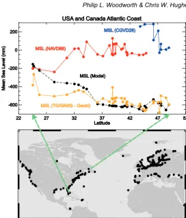
As an example, we show in Fig. 1 a result on the sea level gradient (essentially the variation with latitude of the MDT) along the Atlantic coast of North America, which is a topic that has interested oceanographers for decades (e.g. Sturges 1974), as has discussion of slopes along UK and other coastlines (e.g. Thompson 1980). The conventional method of determining this gradient involved reference of MSL values to the national datums of the US and Canada (red and blue dots, respectively). At first sight these data would suggest that the height of the sea (relative to a “level” surface) increases travelling north from Florida to Canada. However, most modern numerical models of ocean circulation (black dots) demonstrate that the slope of the sea is actually downward, travelling north, primarily due to the effects of the Gulf Stream in this region of the Atlantic Ocean. New models of the geoid, such as those discussed above, have resolved this long-standing controversy by providing conclusive proof that the height of the sea does, indeed, fall going north along the coast (yellow dots), and have shown that the national datums are not true “levels” for reference of heights.
A further result concerned the consistency between the MDT spatial distributions of models provided by the “geodetic approach” employing altimeter data, and the “ocean approach” of pure ocean models. As a first step, maps of the MDT values of the six “pure” models were made and were found to differ with a standard deviation of less than 10 cm in most parts of the ocean, including the coastal oceans, apart from bands of higher standard deviation along the trajectories of the major currents and in Hudson Bay. There are significant, large regions where the standard deviation is less than 2.5 cm.
However, for WHSU we are more interested in how the models perform along coastlines, rather than in the centre of the oceans (which is, of course, of great interest in other contexts). The profiles of MDT of each model around the East Pacific coastline and for the entire Atlantic coastline were found to be in close agreement (~5–10 cm), in spite of the MDT itself varying between –80 and +35 cm as one travels around the coast.
Philip L. Woodworth & Chris W. Hughes
Fig. 1 The apparent north–south slope of MSL along the Atlantic coast of North America derived by three different methods: measured at tide gauges with respect to national datums in the US and Canada (red and blue dots, respectively); determined at the same locations by calculating MSL above the geoid using the state-of-the-art Extended GOCO03S geoid model (yellow dots); and as inferred from a numerical ocean circulation model (black dots). Based on a figure in Woodworth et al. (2012).
geoid models will be particularly severe in this tectonically-active region where the plate boundary coincides with the ocean boundary.
Overall, we assess the agreement between tide gauges and models, between altimetry and models, and between models themselves at the ~5 cm level, which provides an assessment of the present-day accuracy of WHSU from an ocean perspective. We expect this level of agreement to become even closer as geoid models continue to improve. More details of our work may be found in Woodworth et al. (2012).
REFERENCES
Altamimi Z., Collilieux, X. and Métivier, L. (2011) ITRF2008: an improved solution of the International Terrestrial Reference
Frame. J. Geod. 85, 457-473, doi:10.1007/s00190-011-0444-4.
Amalvict, M. and Boavida, J. (1993) The geoid: From geodesy to geophysics and from geophysics to geodesy. Surv. Geophys.
14, 477–494, doi:10.1007/BF00690573.
Bindoff, N., et al. (2007) Observations: oceanic climate change and sea level. In: Climate Change 2007: The Physical Science
Basis. Contribution of Working Group 1 to the Fourth Assessment Report of the Intergovernmental Panel on Climate
Change (ed. By S. Solomon, D. Qin, and M. Manning). Cambridge: Cambridge University Press.
Bouman, J., Floberghagen, R. and Rummel, R. (2013) More than 50 years of progress in satellite gravimetry. Eos, Transactions
of the American Geophysical Union 94, 269–270.
Cartwright, D. E. and Crease, J. (1962) A comparison of the geodetic reference levels of England and France by means of the
sea surface. P. Roy. Soc. London A, 273, 558–580, doi:10.1098/rspa.1963.0109.
Gruber, T., Gerlach, C. and Haagmans, R. (2013) Intercontinental height datum connection with GOCE and GPS-levelling data.
J. Geod. Sci. 2, 270–280, doi:10.2478/v10156-012-0001-y.
Holgate, S. J., et al. (2013) New data systems and products at the Permanent Service for Mean Sea Level. J. Coastal Res. 29,
493–504, doi:10.2112/JCOASTRES-D-12-00175.1.
Mayer-Gürr, T., et al. (2012) The new combined satellite only model GOCO03s. Abstract submitted to the International
Symposium on Gravity, Geoid and Height Systems, Venice, Italy, 9–12 October 2012.
Pavlis, N. K., et al. (2012) The development and evaluation of the Earth Gravitational Model 2008 (EGM2008). J. Geophys.
Rummel, R. (2013) Height unification using GOCE. J. Geod. Sci. 2, 355–362, doi:10.2478/v10156-011-0047-2.
Santamaría-Gómez, A., et al. (2012) Mitigating the effects of vertical land motion in tide gauge records using a state-of-the-art
GPS velocity field. Global Planet. Change 98–99, 6–17, doi:10.1016/j.gloplacha.2012.07.007.
Sturges, W. (1974) Sea level slope along continental boundaries. J. Geophys. Res. 79, 825–830, doi:10.1029/JC079i006p00825.
Thompson, K. R. (1980) An analysis of British monthly mean sea level. Geophys. J. Roy Astro. Soc. 63, 57–73,
doi:10.1111/j.1365-246X.1980.tb02610.x.
Woodworth, P. L., et al. (2009) Trends in UK mean sea level revisited. Geophys. J. Int. 176, 19–30,
doi:10.1111/j.1365-246X.2008.03942.x.
Woodworth, P. L., et al. (2012) Towards worldwide height system unification using ocean information. J. Geod. Sci. 2,