_____________________________________________________________________________________________________
International
20(2): 1-9, 2019; Article no.JGEESI.28026 ISSN: 2454-7352
Application of Radar Imagery to Tectonic,
Structural and Geological Studies in Afikpo Basin,
Southeastern Benue Trough, Nigeria
Minapuye Isaac Odigi
1*and Prince Suka Momta
11
Department of Geology, University of Port Harcourt, Nigeria.
Authors’ contributions
This work was carried out in collaboration between both authors. Both authors read and approved the final manuscript.
Article Information
DOI: 10.9734/JGEESI/2019/v20i230104 Editor(s): (1) Tim G. Frazier, Associate Professor, Department of Geography Director, Hazards and Climate Impacts Research Center (HazCIRC), The State University of New York at Binghamton, USA. Reviewers: (1) José Martínez Reyes, University of the Ciénega of Michoacán State, México. (2)Ahmet Sayar, Kocaeli University, Turkey. (3)Angelo Paone, Pusan National University, South Korea. Complete Peer review History:http://www.sdiarticle3.com/review-history/28026
Received 29 March 2016 Accepted 18 August 2016 Published 05 April 2019
ABSTRACT
Radar imagery was used to identify geological features and the production of geological maps of the Afikpo basin. The essence of this study was to delineate significant geological and geomorphological features that have not been imaged by the traditional ground field mapping. The application of Radar imagery technique will be relevant to the discovery of subsurface structures that will aid the accumulation or concentration of certain economic minerals or natural resources. It will enhance the identification of significant geological information such as lineaments, geologic structures, drainages, etc, that will serve as a guide to the actual ground field work investigation. Results from radar imageries revealed drainage pattern, major geomorphological units, mega lithostratigraphic units, lineaments and structures. The geology of Afikpo basin consist of Cretaceous, Tertiary and Quaternary rocks are recognizable; the highly deformed Cretaceous rocks are characterized by regional lineaments. Some of the rivers are aligned along the regional lineaments. The NW-SE and NE-SW lineaments truncate one another, suggesting different ages for the lineament groups. A few sinistral tensional movements occur in the eastern sector of the basin. The major folds in the Afikpo basin have NE-SW and NW-SE trends, and occur as anticlines and
synclines. The basement structuring and basin framework suggest a tectonic setting in the southeastern Benue Trough resulting from the Early Cretaceous opening of the South Atlantic Ocean and interpolate movement in Africa. From the evidence currently available we may conclude that the post Santonian Afikpo basin falls within the transtenstional basin categories associated with transform faults. The regional tectonics interpreted from the radar imageries are likely hydrocarbon related structural features.
Keywords: Tectonic; structure; radar imagery; geological features.
1. INTRODUCTION
Geological studies can benefit from the application of remote sensing systems (primarily imaging sensors). In most geological exploration projects in Nigeria and all over the world, radar imageries have become very indispensible tools. However, the importance of radar imageries in geological investigations is yet to be fully appreciated in the country. It can be used for the production of reconnaissance geological maps which contain a comprehensive range of lithological and structural information. The method is based on the use of aerial photogeological interpretation, which does not necessarily require extreme sophisticated image processing and is most effective when supported by limited field check. In regional mapping projects such as that currently in progress in most parts of Nigeria and Africa, interpretation of satellite imageries should be the first step for a well-planned programme. This should also include the use of aerial photographs and some geophysical techniques such as aeromagnetic surveys (which the author is currently working on). All these methods have their own advantages which include resolution, cloud
penetration, scale or sensitivity. These
advantages often overlap but can also be complementary. The use of remote sensing systems does not and should not replace actual field observations. It will help to accelerate actual field work by identifying areas of special interest or difficulties in a timely and effective manner.
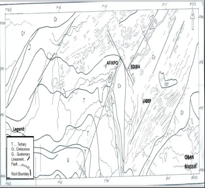
The area investigated in this paper lies within the southeastern part of Nigeria. It is bounded by Longitude 7°45 E and 8°30 E and Latitude 5°00’N and 5°36 N (Fig. 1). About half of the study area is rainforest region with difficult accessibility. Field work is slow and costly, and geological mapping is often inefficient and unproductive. Consequently, comparatively little is known of the regional tectonic and structures of this area. Hence, a better and productive tool of radar imagery is used in this study. The aims
of the study are: to delineate major
lithostratigraphic and geomorphologic units, identify tectonic lineaments and structural features associated with the basin under investigation [1].
The Oban Massif is overlain by Cretaceous– Cenozoic sediments of the Afikpo Basin, Calabar flank and Mamfe Embayment. The Afikpo Basin is part of the southeastern Nigeria sedimentary basins that is bounded by the Niger Delta to the south, the Abakaliki Anticlinorium to the north and the Anambra basin to the west, the Oban massif and the Mamfe rift to the east.
2. MATERIALS AND METHODS
Radar mosaic imagery (Fig. 4) of part of southeastern Nigeria [2] was used for this study with a scale of 1: 250,000. The interpretation of the radar imagery is based on drainage, geology, structural features (bedding surfaces, joints, faults and folds) and lineament pattern analysis. An understanding of the fundamental principles of remote sensing is outside the scope of this paper. It is however difficult to fully appreciate
the advantages and potential of this
technique without a very brief outline of the basis of remote sensing. The term “remote
sensing,” is most frequently used today to mean the collection of information from a
distance through the use of radiant energy. Radiation can be transferred across free space as well as through a medium such as air. Thus, it is that sunlight, a form of radiant energy, crosses the gulf of emptiness between the sun and the earth. The radiant energy emitted is called “electromagnetic energy” in recognition of the fact that it has both electric and magnetic components.
typified by lower frequencies. At the other extreme are the higher frequency forms such as X-rays and Gama rays with short wavelengths. The most prevalent unit used to measure wavelength along the spectrum is the micrometer
(µm). A micrometer equals 1 x 10⁻⁶m.
Wavelength dimensions are used to bound the various regions of the spectrum which have been given names for convenience (e.g. Infra-red, microwave, ultraviolet etc.).
Radar satellite imagery technique uses Synthetic Aperture Radar (SAR), which sends its own microwave signals down to the Earth and processes the signals received in a format that can be interpreted. It contains active sensors with longer wavelength suitable for penetration in rough atmospheric conditions. This accounts for high its recording and data acquisition capacity. It uses an active microwave source onboard of the satellite and measure the back-scatter from the earth’s surface. The back-scatter qualities measured are directly related to the earth’s geomorphology, dielectric properties, and the roughness of the terrain being imaged [3,4]. In addition, radar can acquire multiple images which can be used to provide stereoscopic viewing. Radar remote sensing technique was deployed over some parts of the Afikpo Basin area on a scale of 1:25000 primarily for the detection of geological anomalies and surficial features.
2.1 Regional Geology of South Eastern Nigeria
The evolution of sedimentary basins in South-Eastern Nigeria followed the opening of the South Atlantic and the break-up of the South American and West African plates in late Jurassic times (Fig. 2). The proto-basin of the Benue Trough was the failed arm of rift-rift-rift (RRR) triple junction which extended from the Northern limits of the Niger Delta Basin to the Chad area in the North-East.
A review of the tectonic framework of the inland sedimentary basins of Nigeria has demonstrated that the Benue Trough system was indeed a rejuvenation of existing basement fractures. Wrench movements along these faults resulted in blocks faulting and formation of several sedimentary basins [5]. The Benue Trough system had in the past been conveniently subdivided into the lower, middle and upper Benue Trough. However recent aeromagnetic and gravity data across the entire system has demonstrated the distinct nature of these basins
each with its well defined sedimentary
succession and separated by positive anomaly areas [6,7]. Sediment thicknesses of up to 8km have been recorded in some of these basins within the Trough [8,9]. The depth to basement in Afikpo basin varies from 2.0 to 3.98 km (personal communication with Okereke, 1986).
Fig. 2. Regional structural map showing the major fracture subsystems in the West Africa and Central Africa [5]
2.2 Geology and Stratigraphy of the Afikpo Basin
The Benue Trough is a linear NE-SW trending
intra- continental basin. The Cretaceous
succession in Nigeria is exposed in the Benue Trough (Fig. 3). The Benue Trough is about 85-90 km wide fault-bounded depression containing up to 6000 m of slightly too strongly deformed Cretaceous sedimentary, minor intrusive and extrusive rocks. The Afikpo basin consists of both pre-and post Santonian rocks [10,11].
The sedimentary fill in the Afikpo basin is divided into three tectonic-stratigraphic mega sequences: The Asu River Group, Eze-Aku Group and proto-Niger Delta succession (Fig. 3). The three mega sequences have been intruded by basic to intermediate rocks during the three tectonic events, namely Cenomanian, Santonian and Maastrichtian times [11,12].
In the Afikpo Basin, the oldestsedimentary rocks overlying the Precambrian Basement complex rocks of the Oban Massif are non-marine to marine sediments of Early-Mid Albian in age. The Albian Asu River Group is dominantly shale with siliciclastic and calcareous sandstones. The
oldest sedimentary sequence is of a
conglomeratic to arkosic sandstone, overlain by shales, lower and upper regressive sandstones. The lower and upper sandstone bodies of the Asu River Group are regarded by [13] as Awi and Awe Formations respectively. The Asu River Group is overlain unconformably by the Late Cenomanian-Turonian-Coniacian EzeAku Group, while the Eze-Aku Group is also overlain by the proto-Niger Delta deposits. The proto-Niger Delta basin comprise of Campanian-Maastrichtian and Paleocene sediments which are post-unconformity formations.
3. RESULTS AND DISCUSSION
The analysis of the interpreted drainage patterns in Figs. 4 and 5 shows the Afikpo basin with the following observations relevant to the scope of the study.
3.1 Drainage Pattern
area that flow in the NW-SE, E-W and NE-SW
directions. The NW-SE, E-Wand NE-SW
directions conform to the regional tectonic and structural features of Nigeria sedimentary basins and basement complex terrain [14]. The central sector of the study area is characterized by trellis-like drainage channels located between Unwana, Itigidi and Anonng. The offset drainage channels are interpreted as tectonic controlled. The study area is generally characterized by asymmetrical drainage networks controlled by permeable shale and impermeable sandstone rocks and tectonic setting.
3.2 Morphological Features
Three major geomorphological units –landscapes of structural origin are readily distinguishable. The principal landforms in the area consist of (i) highlands; (ii) plains and (iii) valleys. The sandstone ridges form the highlands and extend
from Owutu through Ndiowere, Amangu,
Amaseri, Afikpo areas, and through Ugep. Sandstone ridges occur at Abini and Adim. In between the ridges are plains that are well drained by rivers originating from the highly fractured, deformed sandstone ridges. Additional
morphological features significant to the
structural-geological interpretation by visual examination of the imagery are deep valleys,
erosion scraps, alignment of knick points in stream courses and the distributions of outcrops.
3.3 Radar Geology
The geologic units easily discernable in the study area highlight the potential of radar imagery in elucidating the geology of Afikpo basin. Basement and sedimentary rocks are identifiable on the radar imagery (Fig. 5). Furthermore, the sedimentary rocks are subdivided into three
mega-lithostratigraphic units: Cretaceous,
Tertiary and Quaternary which were confirmed
during field spot checks [11;15].
Lithostratigraphic units encountered in the field were Asu River Group, Eze-Aku Group and terminal Cretaceous Proto-Niger delta deposits [11]. The first Cretaceous strata after crossing the Oban Massif at the southeast section of Fig. 5 are theAsu River Group sediments overlain by a second Cretaceous strata referred to as Eze-Aku Group. The Eze-Eze-Aku Group is a paralic sequence of two marine transgressive cycles - the Late Cenomanian-Early Turonian, and the Late Turonian –Conacian cycle [16].
The Oban Massif lithologically comprises of three major rock groups-Migmatitic gneisses complex rocks, older granite intrusive and unmetamorphosed doleritic intrusive [17;18].
Fig. 4. Radar mosaic imagery of Oban Massif and Afikpo Basin
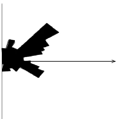
3.4 Regional Lineaments – Linear and Curvilinear Patterns
Lineament in this study is base on the definition of [19]. This definition connotes a lineament as a topographic expression, with possible crustal implication observed on a regional scale. In this study lineaments less than half kilometer length were screened out. A total of 280 lineaments were mapped in the Afikpo basin (Fig. 5).These were separated from a total of 415 mapped in the adjacent basement-Oban Massif located southeast of Afikpo basin (Figs. 4 & 5).The idea for comparing the basement with sedimentary area was to find out whether any sort of tectonic control existed between the two geologic environments. A careful study of the Afikpo basin and Oban Massif, revealed a close correlation between lineaments in the Afikpo basin and Oban massif. The dominant lineaments in the
Oban Massif trend NE-SW with subordinate lineaments trending NW-SE and N-S. The rose diagram constructed quantitatively shows the
maximum stress distribution pattern of
lineaments in the study area (Fig. 6). The Afikpo basin has similar lineament trend, suggesting tectonic control between the sedimentary and Oban massif. Coincidentally, these paleo-trends were observed as crustal fractures in the study of satellite imagery of Nigeria [20].
3.5 Northwest-Southeast Lineaments
This group of lineaments is based on series of escarpments in the sediments. Generally, these rocks have a horizontal to subhorizontal attitude. The western area is clearly reflected by the NW-SE oriented drainage courses, and some of the
manifestation of the fold system is the displacement of the limbs of the complex folds into halves in a left-lateral sense. A few of the
lineaments trending NW-SE have been
established as probable faults.NE-SW to NE-SW lineaments-these constitute a tectonic system. Some of the rivers and streams are aligned along this group of lineaments.
The N-S trending lineaments appear prominent within the southern region of the sedimentary area typical of the Pan-African orogenic mobile belt [21]. The NW-SE and NE-SW lineaments truncate one another in places, suggesting different ages for the lineament groups. For
example, the NE-SW lineament L1 is older than
the NW-SE lineament L2. The N-S lineaments
form another generation of tectonic system which
is older than the L1 and L2 lineaments. These
tend to suggest that an important tectonic episode occurred in the Cretaceous sedimentary basins of Nigeria. Generally, the different lineament systems seem to delineate blocks containing folded structures. During the early episode, the NE-SW structures were formed with corresponding fold axial traces. The later folding produced NW-SE trending structures.
The regional lineaments identified in Fig. 5, are considered to be Cretaceous fracture zones traces that continued from the Gulf of Guinea beneath the Abakaliki-Benue areas then the possibility must be considered that transtentional (pull apart) basin may occur.
Fig. 6. Directional frequency rose diagram of interpreted fractures
4. CONCLUSIONS
It is concluded that the radar imagery under consideration in the Afikpo basin can be usefully applied by visual examination to the delineation of major lithostratigraphic units; the Cretaceous,
Cenozoic and Quaternary and regional
lineaments of tectonic origin. The study further reveals that important tectonic episodes occurred in the Afikpo basin during the Cretaceous. NE-SW to NE-NE-SW lineaments-these constitute a tectonic system. Some of rivers and streams are aligned along this group of lineaments. At the eastern sector of the basin along Itigidi and Anonng, there is an evidence of tectonic controlled drainage system showing offset of river channels. The N-S trending lineaments appear prominent within the southern region of the sedimentary area typical of the Pan-African orogenic mobile belt [17]. The NW-SE and NE-SW lineaments truncate one another in places, suggesting different ages for the lineament groups.
Generally, the different lineament systems seem to delineate blocks containing folded structures. During the early episode, the NE-SW structures were formed with corresponding fold axial traces. The later folding produced NW-SE trending structures.
From the evidence currently available we may conclude that the post-Santonian Afikpo basin fall within the transtentional basin categories associated with transform faults.
COMPETING INTERESTS
Authors have declared that no competing interests exist.
REFERENCES
1. Short KC, Stauble AJ. Outline of geology
of Niger Delta: American Association of Petroleum Geologists Bulletin. 1967;51: 761-779.
2. Odigi MI, Okonny IP. Application of radar
imagery to structural and geological studies in the Oban Massif, SE Nigeria. Journal of African Earth Sciences. 1987; 6(3):275-280.
3. Dekker F. 1996. RADARSAT Geology
Handbook subscene of Venezuela © Canadian Space Agency/Agence spatial ecanadienne RADARSAT International; 1996.
Available:www.radarsatinaction .com
4. Andreas Laake. Integration of satellite
imagery, geology and geophysical data, earth and environmental sciences, Dr. Imran Ahmad Dar (Ed.). 2011;ISBN:978-953-307-468-9, InTech.
5. Popoff M. Du Gondwanua I’’
Atlantiquesud: Les connexions du poss de la benone avec les basins du nord-East bresilienjusqu’alouvertune du GolRe de guinea intereur. Journal African East Science. 1988;7:409-431.
6. Cratchley CR, Jones GP. An interpretation
of the Geology and gravity anomalies of the Benue valley, Nigeria. Overs. Geol. Surv. Geophys. 1965;26:Paper No. 1.
7. Ofoegbu CO, Odigi MI, Okereke CS,
Ahmed NM. Magnetic anomalies and structures of Nigeria’s Oban Massif. Journ. African Earth Sciences. 1992;15(2):271-280.
8. Ofoegbu CO. A review of the geology of
the Benue Trough of Nigeria. Journal of African Earth Sciences. 1984;3:283-291.
9. Ofoegbu CO. A model for the tectonic
evolution of the Benue Trough of Nigeria, Geologischen Rundschau. 1985;73:1007-1017.
10. Whiteman A. Nigeria: Its Petroleum
Geology, Resources and Potential. 1982;1: 177.
11. Odigi MI. Facies and Sequence
12. Odigi MI, Amajor LC. Geochemical characterization of Cretaceous Sandstone sequences from the southern Benue Trough, Nigeria. Chinese Journal of Geochemistry. 2009;28(1):49-54.
13. Petters SW, Ekweozor. Petroleum geology
of the Benue Trough and SE Chad Basin, Nigeria, AAPG Bull. 1982;66:1141-1149.
14. Rahaman MA. Review of the basement
geology of southwestern Nigeria. In: Geology of Nigeria (Ed, Kogbe CA). 1976; 41-58.
15. Odigi MI. (In prep). Geological field guidee to
Afikpo Basin, Southeastern Nigeria.
16. Petters SW. Southeastern Benue Trough
and Ikom Mamfe Embayment. In:
Geological Excursion Guidebook to Oban
Massif, Calabar flank and Mamfe
Embayment, southeastern Nigeria. Part 2, 1995;26-36.
17. Rahman A, AMS, Ukpong EE, Azmatullah
M. Geology of the Oban Massif,
southeastern Nigeria. Nigerian Journal of Min and Geol. 1981;18(1):60-65.
18. Odigi MI. Accessory Minerals in the Oban
Massif granitoid plutons of Southeastern Nigeria-their qualitative and quantitative significance in fertility studies. Journal of African Earth Science. 1985;5(2):163– 166.
19. O’Leary DW. Freidman JD, Pohn HA.
Lineament, linear, lineation: Some
proposed new definitions for old terms. Geological Society of America Bulletin. 1976;87:1463-1469.
20. Chuku-Ike IM, Norman JW.
Mineralized crustal failures shown on Satellite imagery of Nigeria. Inst. Mining Metal. Trans. (Sect. B, Appl. Earth. Sci). 1977;86:B55-B57.
21. Kogbe CA. Geological Interpretation
of Landsat imageries of part of
Central Nigeria. Journ. Min. Geol.
1981;18:66-69.
_________________________________________________________________________________ © 2019 Odigi and Momta; This is an Open Access article distributed under the terms of the Creative Commons Attribution License (http://creativecommons.org/licenses/by/4.0), which permits unrestricted use, distribution, and reproduction in any medium, provided the original work is properly cited.
Peer-review history:
![Fig. 1. Geological map showing four major structural domains in southeastern Nigeria [1]](https://thumb-us.123doks.com/thumbv2/123dok_us/8376398.1677024/3.612.156.458.454.687/fig-geological-showing-major-structural-domains-southeastern-nigeria.webp)
![Fig. 2. Regional structural map showing the major fracture subsystems in the West Africa and Central Africa [5]](https://thumb-us.123doks.com/thumbv2/123dok_us/8376398.1677024/4.612.97.518.98.362/regional-structural-showing-fracture-subsystems-africa-central-africa.webp)