Forensic geophysics: assisting law enforcement agencies in clandestine grave detection – 4-6 pages
Jamie K. Pringle, Senior Lecturer, School of Physical and Geographical Sciences, Keele University, Staffs, UK. Email: [email protected]
Henry C. Dick, PhD student, School of Physical and Geographical Sciences, Keele University, Staffs, UK. Email: [email protected]
1. Introduction
Thousands of people are reported missing in the world every year to their respective Police Services, 250,000 annually in the United Kingdom alone (UK Home Office, 2010). In other countries, with larger populations, these figures will be considerably more, for example, the US National Crime Information Center lists 84,136 missing persons cases as of 2013, with ~57,000 currently missing in Colombia (Molina and others, 2016). Where the missing have sadly become homicide victims, their bodies are commonly hidden inside structures (see Ruffell and others, 2014), deposited in water (see Parker and others, 2010) or buried in terrestrial environments (see Pringle and others, 2012). Where these cases are unsolved, they are commonly referred to as ‘cold cases’ which periodically get revisited every decade or so, where new case information may come to light and/or forensic techniques have been recently developed which may assist with the investigation.
There are various methods used for detection of these victims, with best practice suggesting a phased approach, moving from large-scale remote sensing methods to suggest likely areas, down to ground reconnaissance and control studies of suspect area(s) before full site searches are initiated (see Larsen and others, 2011, Pringle and others, 2012). Full site searches can include a variety of techniques, including forensic geomorphology, scent-trained ‘cadaver’ victim recovery dogs, chemical analysis of soil/water samples and near-surface forensic geophysics. Near-surface geophysical methods are being increasingly used by forensic search teams to assist them with detecting a variety of forensic-related items of interest.
Forensic geophysics has been defined as ‘the study of locating and mapping hidden objects or features that are underground or underwater’ (Dupras and others, 2011) for both civil and criminal court purposes. Geophysical methods should be able to non-invasively, rapidly survey extensive suspected areas; subsequent targeted anomalies can then be investigated using conventional and forensically careful, intrusive methods. Forensic geophysical targets are many, the highest profile of which are both isolated and mass clandestine graves of homicide victims, but other targets, for example, weapons used in robberies, weapons, drugs and money caches, are also important forensically to locate for criminal and civil courts, with environmental forensics to locate, characterise and, ideally, time the illegal dumping of waste also becoming more common (see Pringle and others, 2012).
The dominant near-surface geophysical technique currently utilised globally for terrestrial searches is ground penetrating radar or GPR (Fig. 1). It is easily portable, has good resolution (depending upon the antenna frequency being utilised) and penetration (depending upon soil type), and data is able to be both viewed in real-time and GPS positioned. Usually mid-range frequencies (200 MHz – 500 MHz) are mostly used for forensic investigations, on ~0.5m spaced traverses and ~0.1m sample spacings, depending upon the target size being searched for. However, it has been suggested that in some cases, it has been used based on past successes and without consideration of local depositional conditions (see Table 1). It is also particularly used to pinpoint historic and unmarked grave burials (see the FastTIMES article by Lachlab and Zawacki, 2015).
Electro-magnetic (EM) methods, which include metal detectors, are also commonly used, often as the initial field geophysical technique, as they are relatively quick. Metal detectors have the transmitter and receiver together and therefore have very good resolution, other EM equipment have these separated, which usually results in them not having as high resolution as other methods, although the penetration depths for the latter are better. EM datasets would be typically acquired on 1m spaced traverses and ~0.5m sample spacings. Apart from metal detectors, EM surveys are mainly used for detecting disturbed from ‘natural’ ground (and thus may not be useful in urban searches), metallic items and or waste which are conductive and items that are contained with or beside the target(s) of interest, as well as items left behind by the perpetrator(s). However, caution should be used for intrusive investigation of anomalies in a search site; used before other geophysical
techniques, any intrusive investigations created by the detector search teams may then themselves be identified as a target by subsequent geophysical searches (Fig. 2). They are also problematic in urban or culturally ‘noisy’ environments where above-ground EM sources may interfer with results (Table 1).
Electrical resistivity (ER) techniques, the inverse of EM methods, have been widely used for ancient burials searches, clandestine grave searches (particularly in clay-rich soils which may preclude GPR to be used – see Fig. 2) and for larger targets (see Pringle and others, 2012). Resistivity surveys have the advantage of
measuring probes being physically inserted into the ground and are therefore less affected by above-ground sources of interference (Fig .2). Datasets are typically collected on 0.5m spaced traverses and 0.5m sample spacings, depending on target size. However search results, whilst useful to pinpoint suspect area(s), may be due to soil moisture content variations in heterogeneous soil rather than due to targets, and thus careful data processing is necessary and potentially other technique(s) may be necessary to confirm if target(s) are present are positions before intrusive
investigations are undertaken.
Figure 1: Photograph of a forensic geophysics search site in the United Kingdom to look for a homicide victim. A GPR survey has been undertaken on 0.5 m spaced survey lines, with suspect anomalous areas being marked by yellow flags for investigation teams to intrusively investigate.
77 78 79 80 81 82 83 84 85 86 87 88
Figure 2: Photograph of a forensic geophysics search site in the United Kingdom to look for a homicide victim. A metal detector search team have already been onsite and dug up where metal was indicated (water-filled holes). Due to the clay-rich soil type of the site, a fixed-offset, dipole-dipole electrical resistivity survey has been undertaken (in background).
Finally magnetic methods have also been used in forensic searches, particularly looking to recover metallic weapons, or when metallic objects are left within an unmarked or clandestine grave. Various magnetometers are typically used on 0.5m spaced traverses and 0.25m sample positions, with total field magnetometers utilised for big targets, magnetic gradiometry for smaller objects within 1 m of the ground surface, to even magnetic susceptibility surface probe surveys for more subtle targets or to look for disturbed ground (see Fig. 3).
Figure 3: Magnetic susceptibility surface survey to detect an Anglo-Saxon grave in East Anglia, United Kingdom. a. digitally contoured gridded surface of MS results with subsequent b. excavated skeleton outline superimposed, interestingly not containing any metal. Modified from Pringle and others, 2015.
With the development of faster data acquisition technologies, particularly towed geophysical instrumentation, automated robot surveys, and drone technologies (see FastTIMES March 2016 Special Drone Issue), terrestrial searches using forensic geophysics should become increasingly common. However, considerations need to be given on the individual case, which is where controlled geophysical research comes in.
3. Controlled forensic geophysical research
Controlled research using simulated clandestine graves have proven critical to determine the optimal geophysical technique(s) and equipment configurations to maximise the potential for target detection success (see, for example, Schultz and Martin, 2012 and Pringle and others, 2016). Controlled research by various authors has also determined the major site variables that affect burial detection. The most 108
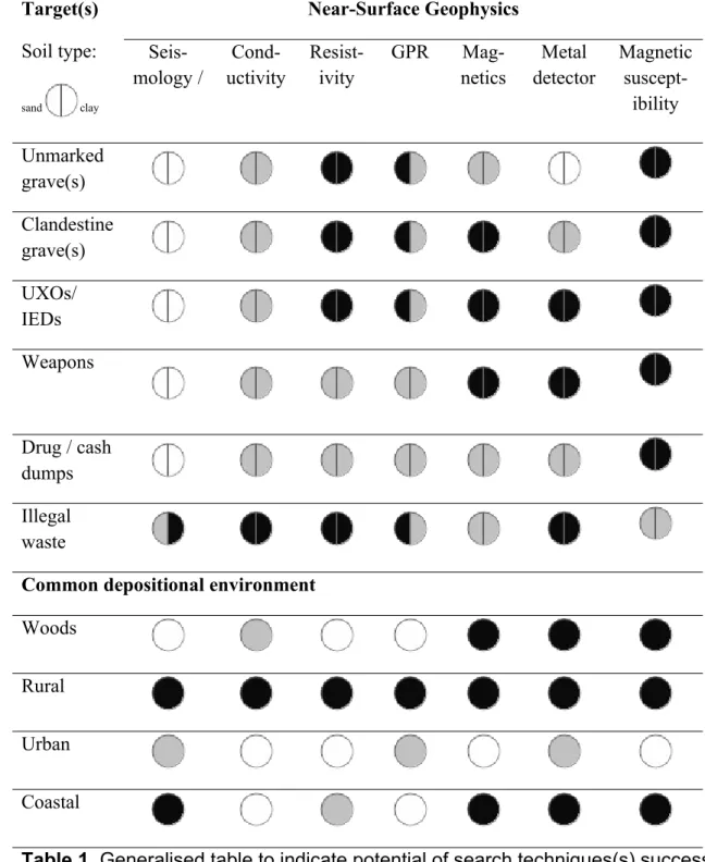
important variable is time since burial, over time the disturbed soil over a buried target will compact to leave this target to be more difficult to differentiate from background values. For clandestine burials the style of burial is important, if it is wrapped/clothed it will have a big difference geophysically, wrapping will prevent conductive decompositional fluids from escaping and being detected, but the wrapping itself provides a good radar reflective surface. The local soil type is also important, clay-rich soils, for example, result in rapid attenuation of radar waves and thus usually results in poor penetration so electrical resistivity surveys may be optimal in this scenario. Finally the local depositional environment including surface vegetation is an important variable, dense forests would preclude the use of GPR and electrical resistivity due to them imaging tree roots, thus EM or magnetics may be optimal here. Table 1 details the optimal techniques in different depositional environments.
Clandestine burials are quite different from historic graves in graveyards and cemeteries, the actual target will change depending on the time since burial and decomposition stages; this will then effect which technique should be. Early
decomposition results in lighter than air gases escaping which would make methane probes and search dogs optimal, later stage decomposition would release ‘leachate plumes’ that could be detected electrically, whilst skeletonised remains would be best detected by GPR (see Fig. 4).
Figure 4: Schematics and potential ‘grave’ markers of the clandestine and cemetery burial stages. (A) Recent burial, surface expression is most obvious. (B) Early 128
129 130 131 132 133 134 135 136 137 138 139 140 141 142 143 144 145 146 147 148 149
decomposition with forensic geomorphologists (surface changes), search dogs and/or methane probes being optimal. (C) Late-stage decomposition with forensic geomorphologists and grave soil fluids being an ER target. (D) Final skeletonised decomposition with GPR being optimal. These contrast with (E) isolated static graveyard/cemetery burial showing typical geophysical targets including forensic geomorphology, back-filled grave soil, coffin/contents and ‘grave fluid’. Modified from Pringle and others, 2016.
Target(s)
Soil type:
sand clay
Near-Surface Geophysics
Seis-mology /
Cond-uctivity
Resist-ivity
GPR Mag-netics
Metal detector
Magnetic
suscept-ibility
Unmarked grave(s)
Clandestine grave(s)
UXOs/ IEDs
Weapons
Drug / cash dumps
Illegal waste
Common depositional environment
Woods
Rural
Urban
Coastal
Table 1. Generalised table to indicate potential of search techniques(s) success for buried target(s) assuming optimum equipment configurations. Note this table does not differentiate between target size, burial depth/age and other important specific factors (see text). Key: Good; Medium; Poor chances of success. The dominant sand | clay soil end-types are detailed where appropriate for simplicity, 161
therefore not including peat, cobbles etc., types. Modified from Pringle and others (2012).
Conclusions
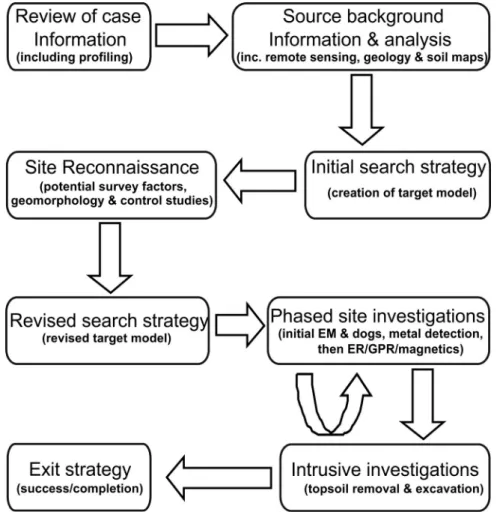
Every forensic geophysical search is unique, therefore a good knowledge of the case background and potential suspected site(s) should be gained before a sequential site investigation(s) is initiated. Creating a conceptual target model and continually refining this when new information comes available will assist forensic search teams in developing a detailed and focussed search plan. Analysis of large-scale (remote sensing) techniques should be undertaken before ground reconnaissance and control studies are initiated. Key considerations when considering a forensic
geophysical survey are exhaustive but should, as a minimum, consider the local soil type and environment, likely time since burial and target size and style. If time is not a factor, certain surveys are optimal in certain seasons, for example electrical
resistivity surveys have been shown to be more successful in wetter winter ground conditions. Lastly a clear written workplan should be created as an exit strategy in case the target is not identified using geophysical methods. Figure 5 gives a generalised typical search programme workflow using forensic geophysics. 166
167
Figure 5: Generalised forensic search programme workflow (modified from Pringle and others, 2012).
References:
Dupras, D., Schultz, J., Wheeler, S., and Williams, L., 2011, Forensic Recovery of Human Remains: Archaeological Approaches: Taylor and Francis, Boca Raton, Florida, USA, 232pp.
Lachlab, A., and Zawacki, A.J., 2015, Comparison of two GPR surveys with different grid spacings to identify unmarked graves in a 19th Century cemetery at Snyder
County, PA: FastTIMES, v. 20, n.3, p. 33-42.
Larson, D.O., Vass, A.A., and Wise, M., 2011, Advanced scientific methods and procedures in the forensic investigation of clandestine graves, Journal of
Contemporary Criminal Justice, v. 27, p. 149-182.
Molina, C.M., Pringle, J.K. Saumett, M., Hernandez, O, and Evans, G.T., 2016, Geophysical monitoring of simulated graves with resistivity, magnetic susceptibility, conductivity and GPR in Colombia, South America, Forensic Science International, v. 261, p. 106-115.
Parker, R., Ruffell, A., Hughes, D. and Pringle, J., 2010, Geophysics and the search of freshwater bodies: a review: Science and Justice, v. 50, p. 141-149.
Pringle, J.K., Jervis, J.R., Roberts, D., Dick, H.C., Wisniewski, K.D., Cassidy, N.J. and Cassella, J.P., 2016, Geophysical monitoring of simulated clandestine graves using electrical and ground penetrating radar methods: 4-6 years: Journal of Forensic Sciences, v. 61, p. 309-321.
Pringle, J.K, Wisniewski K., Giubertoni, M., Cassidy, N.J., Hansen, J.D., Linford, N.J. and Daniels, R.M., 2015, The use of magnetic susceptibility as a forensic search tool, Forensic Science International, v. 246, p. 31-42.
Pringle, J.K., Ruffell, A., Jervis, J.R. Donnelly, L., McKinley, J., Hansen, J., Morgan, R., Pirrie, D., Harrison, M., 2012, The use of geoscience methods for terrestrial forensic searches: Earth Science Reviews, v. 114, no. 1-2, p. 108-123.
Ruffell, A., Pringle, J.K., Forbes, S., 2014, Search protocols for hidden forensic objects beneath floors and within walls, Forensic Science International, v. 237, p. 137-145.
Schultz, J.J., and Martin, M.M., 2012, Monitoring controlled graves representing common burial scenarios with ground penetrating radar: Journal of Applied Geophysics, v. 83, p. 74–89.
United Kingdom Home Office, 2010, The Missing Persons Taskforce: A report with recommendations for improving the multi-agency response to missing incidents. London: Home Office.