A Forward GPS Multipath Simulator Based on the Vegetation Radiative Transfer Equation Model
Xuerui Wu1,2
* Shuanggen Jin1
1. Shanghai Astronomical Observatory, Chinese Academy of Sciences, Shanghai 200030, China
2. Key Laboratory of Planetary Sciences,Shanghai Astronomical Observatory, Chinese Academy of Sciences, Shanghai 200030, China
* Correspondence: Email: [email protected]
Tel: +86-21-34775291; Fax: +86-21-64384618
Abstract—GNSS have been widely used in navigation, positioning and timing. Nowadays, the multipath errors previously considered detrimental may be re-utilized for the remote sensing of geophysical parameters (soil moisture, vegetation and snow depth), e.g. GPS- Multipath Reflectometry (GPS-MR). In this paper, a new element describing bistatic scattering properties of vegetation is incorporated into the traditional GPS-MR model. This new element is the first-order radiative transfer equation model. The new forward GPS multipath simulator is able to explicitly link the vegetation parameters with GPS multipath observables (signal-to-noise-ratio (SNR), code pseudorange and carrier phase observables). The trunk layer and its corresponding scattering mechanisms are ignored since GPS-MR is not suitable for high forest monitoring due to the coherence of direct and reflected signals. Based on this new model linking the GPS observables (SNR, phase and pseudorange) with detailed vegetation parameters, the developed simulator can present how the GPS signals (L1 and L2 carrier frequencies, C/A, P(Y) and L2C modulations) are transmitted (scattered and absorbed) through vegetation medium and received by GPS receivers. Simulation results show that wheat will decrease the amplitudes of GPS multipath observables, if we increase the vegetation moisture contents or the scatters sizes (stem or leaf), the amplitudes of GPS multipath observables (SNR, phase and code) decrease. Although the Specular-Ground component dominates the total specular scattering, vegetation covered ground soil moisture has almost no effects on the final multipath signatures. Our simulated results are consistent with published results for environmental parameter detections with GPS-MR.
Index Terms—GNSS-R; multipath; radiative transfer equation model; vegetation; simulation
Introduction
Global Navigation Satellite Systems (GNSS) have reached a new era with wider applications than navigation, timing and positioning due to GNSS-R (GNSS-Reflectometry). Compared with traditional remote sensing techniques, GNSS-R has advantages of exploiting pre-existing transmission sources and has wide spreading applications from meso-scale ocean remote sensing to soil moisture and vegetation detections on the land surface (Jin and Komjathy 2010).
In order to receive the reflected signals, a special receiver should be designed, such as the modified DMR (Delay Doppler Maps Receiver) used in SMEX (Soil Moisture Experiment) airborne GPS-R remote sensing experiments (Masters et al. 2004) ,BAO-Tower (Boulder Atmospheric Observatory-tower) experiments (Zavorotny et al. 2003 ) or the SAM sensor (An innovative GNSS-R system for Soil Moisture retrieval) used in the LEiMON (Land Monitoring with Navigation Signals) experiments (Egido et al. 2011).
As for GPS-Interferometric Reflectometry (GPS-IR), an efficient method for geophysical parameter retrieval is to employ the interferometric signals of direct signals and reflected signals. A specially designed GPS receiver named SMIGOL (Soil Moisture Interference pattern GNSS Observations at L-band Reflectometer) (Rodriguez-Alvarez et al. 2011.). or an extension of PSMIGOL (dual-polarization SMIGOL) have been designed for their work (Alonso-Arroyo et al. 2014. ). Based on the in-situ measurements, Rodriguez-Alvarez et al have given good quantitative retrieval results.
height was an efficient metric for snow depth retrieval (the correlation parameter is 0.7~0.9)( Larson et al. 2013 ); Similarly, Chew et al. pointed out that when the vegetation wet weight was below 1.5 kg.m2, the metric of amplitude could be used to estimate vegetation amount. Since phase was very sensitive to soil moisture (Chew et al. 2014), it was not a suitable indicator for detecting vegetation changes (Chew et al. 2015).
A 1-D plane-stratified model has previously been employed in their vegetation amount study (Chew et al. 2015). The model is separated into two stages, with the first being the permittivity profile generation that is then input into the second stage (reflector power at the antenna). The intention of the 1-D plane-stratified model was to divide the soil depth and vegetation canopy into a 1-D stratified permittivity profile, which input into the right- and left-handed reflection coefficients. The reflection coefficients were then combined with the corresponding antenna gain to get the final reflected power at the antenna.
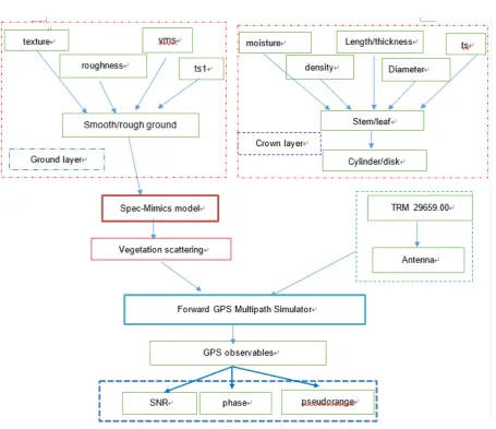
In order to better understand the internal mechanisms, it is necessary to develop an appropriate multipath model. Currently there are three kinds of GPS multipath simulators: one is a tracking simulator assuming arbitrary values for the reflected power, another is a geometry simulator adopting empirical values, and the last is a polarimetric model that calculates the complex reflectivity. However, most of the present models are not available to users. Recently Nievinski and Larson (Nievinski and Larson, 2013, 2014) developed a forward multipath GPS simulator that was based on the physical model proposed by Zavorotny et al. (Zavorotny et al. 2010). This model combined the antenna type and the surface characteristics.
mechanisms, considering only the crown layer and ground layer that remain when simulating the relatively low agriculture (compare to the high forest).
After incorporated the Bi-mimics model (Liang et al. 2005.) into the forward multipath simulator (Nievinski and Larson, 2013, 2014), a new multipath simulator is formed, and it is the first time for a combination of a forward GPS multipath simulator has been combined with microwave vegetation radiative transfer equation model. Using our new developed GPS multipath model, the interactions of GPS signals (L1, L2, C/A, P(Y) and L2C modulations) with vegetated targets can be better understood assisting in data explanation, field experiment design, and vegetation parameter retrieval from GPS-MR. In the next section, we describe the theory and methodology used in this study, followed by the simulation results.
Theory and Methodology
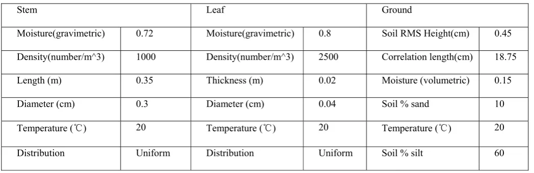
Table 1 Vegetation inputs for the simulator. vegetation is modeled by a crown layer (composed of stem and leaf) and ground layer.
The vegetation scattering model
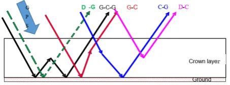
Mimics (Michigan Microwave Canopy Scattering Model) model has been developed for monostatic (backscattering) radar systems (Ulaby et al. 1988). However, GNSS-R is typically a bistatic radar, so a bistatic scattering model referred to as Bi-Mimics model has been developed using the work of (Liang et al. 2005). The Bi-Mimics model is based on the first-order solution of RT model, where first-order refers to solving with a single scattering from each region and double scattering from pairs of regions. This model comprises a crown layer, a trunk layer and a rough-surface ground boundary. Dielectric cylinders (representing needles and branches) and disks (representing leaves) are used to model the crown layer. The trunk layer is simulated by large vertical dielectric cylinders of uniform diameter. The underlying ground is modeled as a rough dielectric surface using a root mean square (RMS) height and a correlation length to characterize its roughness properties. Bistatic scattering model based on RT theory is used to describe the changes of propagating GPS intensity by the process of extinctions and emissions. Due to the coherence limitations of direct and reflected signals of GPS-MR and the obscuration of the direct signals, this technique is not suitable for large forests (Small et al. 2010.). For this reason, only low crop or shrubs are considered and we therefore eliminate the trunk layer. The crown layer and ground layer have been reserved. The scattering mechanisms measured in bistatic directions are shown in Figure 2.
Stem Leaf Ground
Moisture(gravimetric) 0.72 Moisture(gravimetric) 0.8 Soil RMS Height(cm) 0.45 Density(number/m^3) 1000 Density(number/m^3) 2500 Correlation length(cm) 18.75 Length (m) 0.35 Thickness (m) 0.02 Moisture (volumetric) 0.15
Diameter (cm) 0.3 Diameter (cm) 0.04 Soil % sand 10
Temperature (℃) 20 Temperature (℃) 20 Temperature (℃) 20
1
Fig. 2. Scattering mechanisms in the Bi-Mimics model (only the crown layer and the ground layer are retained, while the trunk layer has been eliminated.) including D-G (direct ground),G-C-G (ground reflection and crown scattering and ground reflection),G-C(ground reflection and crown scattering ),C-G(crown scattering and ground reflection) and D-C(direct crown scattering). While the specular ground reflection is not shown in the figure (S-G).
For the same scattering mechanism, it has the same color for the arrows and the top legend
(
,)
(
,) (
,)
s s s s s i i i
I θ ϕ =T θ ϕ I θ ϕ (1)
Assum that the incident intensity Ii impinges on the top surface of the canopy from the direction
, while the upward scattering intensity is in the direction . The first-order bistatic
transformation matrix T links the changes between and Ii(1).
(
s)
(
)
(
s)
P θ ϕ θ ϕ, ; ,s i i =Nk
f sk, ,θ ϕk k ×Lm θ ϕ θ ϕ θ ϕ, ; , ; ,s i i k k ds d dk θ ϕk k(2)
(
)
(
)
(
)
(
)
(
)
(
) (
)
(
)
(
)
(
) (
) (
)
2 2 * *
2 2 * *
* * * * * *
* * * * * *
2 2
2 2
vv vh vh vv vh vv
hv hh hh hv hv hh
m
vv hv vh hh vv hh vh hv vv hh vh hv
vv hv vh hh vv hh vh hv vv hh vh hv
S S R S S S S
S S R S S S S
L
R S S R S S R S S S S S S S S
R S S S S S S S S R S S S S
η −ℑ −ℑ = + −ℑ − ℑ ℑ + − (3)
The phase (2) and extinction (3) matrices are used to represent the transformation matrix T. The
phase function relates the scattered intensity
(
θ ϕs, s)
to the incident intensity(
θ ϕi, i)
(2).k is the number of scatters, Nk is the scatter number density, Sk is the size of scatter, and its orientation
(
θ ϕk, k)
is described by the distribution . Lmis the modified Mueller matrix (3).(
θ ϕi, i)
Is(
θ ϕs, s)
s
I
(
)
(
)
(
)
(
)
(
)
(
)
(
)
(
)
(
)
(
)
(
)
(
)
(
)
(
)
2 0 0 2 2 2 2 2vv vh vh
hh hv hv
hv vh vv hh vv hh
hv vh vv hh vv hh
M M M
M M M
k
M M M M M M
M M M M M M
− ℜ −ℜ −ℑ − ℜ −ℜ ℑ = − ℜ − ℜ −ℜ + ℑ − ℑ − ℑ −ℑ − −ℜ +
(4)
(
0 0)
1 0
2
, ; , ; , ; , ,
K
k
pq pqk k k k
k
i N
M S p q v h
k
π θ φ θ φ θ φ
=
=
= (5)The extinction matrix of a medium containing random scatters is given by (4), it represents the attenuation of the Stokes parameters due to absorption and scattering.
As for type scatter at pq polarization, Spqk
(
θ ϕ θ ϕ θ ϕ, ; , ; ,0 0 k k)
is the average scatteringamplitude coefficient.
( )
( )
( )
( )
2 2 * * * *0 0 0
0 0 0
0 0 Re Im
0 0 Im Re
v
h
v h v h
v h v h
r r R
r r r r r r r r
= −
(6)
The reflectivity matrix of the specular ground surface is given by (6). As for the rough surface, the ground surface scattering matrix G is calculated by the random surface scattering model (Kirchhoff model or Small Perturbation Model) ( Zavorotny et al. 2010 ).
With the above phase matrix (2), extinction matrix (4) and the ground surface matrix (6), it is able to calculate the transformation matrix T in Equation1.
(
, , ,)
4 r trt r r t t Y M Ym m m
σ ψ χ ψ χ = π (7)
Using the wave synthesis technique (7) (Ulaby and Elachi, 1990), the scattering cross sections
of any combinations of transmitted and received polarizations can be got. and are the
modified stokes vectors of the transmitted and received wave. The modified Mueller matrix is
got from the transformation matrix T (1).
If we set the observatory angles as and modify the corresponding phase,
k t m Y r m Y m M ,
s i s i
extinction and ground surface matrices, the bistatic scattering model Bi-Mimics can be applied to specular reflections is referred to as the Spec-Mimics model.
The improved multipath GPS simulator
Recently, a GPS multipath simulator written in Matlab/Octave(Mccreight et al. 2014,Larson et al. 2013) has been made available to the general scientific community. The model is capable of predicting GPS multipath observables (SNR, carrier phase and code pseudorange) by coupling different surfaces and antenna types.
Chew et al. adapted an electrodynamics forward model developed in the paper(Chew et al. 2015) to model SNR data. In order to simulate the vegetation scattering, a plane-stratified model was employed, which did not take internal canopy geometry into considerations (Chew et al. 2015).
2
2
cos sin
r
cos sin
v ε θ ε θ
ε θ ε θ
− −
=
+ − (8)
2 h 2 cos sin r cos sin θ ε θ θ ε θ − − =
+ − (9)
(
)
1 2
RR LL rv rh
ℜ = ℜ = + (10)
(
)
1 2
RL LR rv rh
ℜ = ℜ = − (11)
Equation (8) to (11) are the simpler Fresnel reflection coefficients at V, H, RR and LR polarizations, respectively. Using the dielectric constant of different medium (such as vegetation), we can get the corresponding Fresnel reflectivities at different incident anglesθ .
Although polarization and coherence can be taken into account, the ground reflectivity is calculated using the Fresnel theory by different dielectric constants, such as snow, bare soil and vegetation. However, this simple form of reflectivity is not sufficient to describe the propagation of microwave wave (L band) in the vegetation. It cannot represent the coherent and non-coherent
scattering, and also cannot represent the scattering mechanisms, as shown in Figure 2. But if we want to pay more attention to the effects of environmental parameters on the final GPS multipath observables (SNR, phase and code pseudorange), we need a microwave scattering model to better understand the interactions of GPS signals with vegetated targets, which assist in vegetation parameter retrieval from GPS-MR measurements.
Here, an improved forward GPS multipath model based on the RT model (Liang et al. 2005,
Ulaby et al. 1988)is employed. The development of the model is to use a vegetation bistatic scattering model (Liang et al. 2005) to replace the original Fresnel reflectivity with vegetation permittivity. A more detailed description of the microwave scattering model (Nievinski and Larson, 2013,Zavorotny et al. 2010) has given in section of the vegetation scattering model.
Simulations and results
With the above improved multipath GPS simulator, theoretical simulations of vegetation parameters effects now provided. We begin with the comparisons between bare soil and vegetation on GPS multipath observables, where the main features of vegetation moisture content and sizes are also illustrated. Meanwhile, specular scattering cross sections calculated by the Bi-Mimics model are also presented in order to interpret the effects of vegetation characteristics on final GPS multipath observables.
Bare soil and wheat comparisons
Models given inHallikainen et al. (1985) and Dobson et al. (1985)are used for the calculations of soil permittivity. As for the RT model, all vegetation components are treated like different combinations of single microwave scatters: flat circular disks, dielectric cylinders or probate spheroids. Wheat is selected as a representational vegetation for simulations: its stem and leaf are modeled as dielectric cylinder and disks, respectively. Model inputs are given in Table 1.
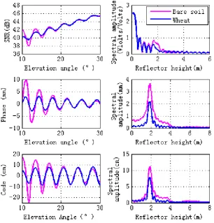
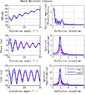
both bare soil and wheat, are consistent with the filed GPS multipath study (Chew et al. 2015)
and there is a sinusoidal-like style for the final interference pattern. As can be seen from Figure 3,
when the elevation angles are larger than 10°and lower than 30°, wheat decreases the magnitudes of the GPS multipath observables (SNR, phase and pseudorange). Lomb-Scargle periodograms are computed for GPS multipath signatures. The right panel of Figure 3 shows that wheat causes the peak amplitude of the GPS multipath observables to decrease, especially the phase and code pseudorange spectral amplitude.
Fig. 3. Comparisons of GPS multipath simulation between vegetation (veg) and bare soil (soil). Model inputs for bare soil is the same as the ground layer of vegetation. Bare soil is shown pink, wheat in blue. Lomb-Sargle
periodograms computed for the GPS multipath signatures are shown in the right panel in plots
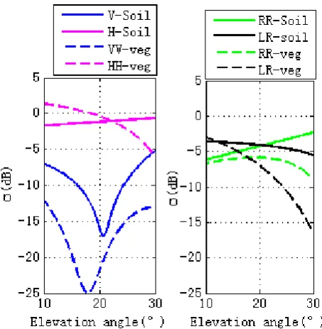
scattering surface’s properties. Specular scattering comparisons with vegetation and bare soil are shown in Fig.4, where the left figure is for linear polarizations and the right is for circular polarization. For soil and vegetation, there is a notch for V polarization in the vicinity of Brewster angle, with the scattering cross section for V polarization being larger than H polarization. For V polarization, the scattering cross section of soil is larger than vegetation. While for H polarization,
scattering cross section of vegetation is larger than soil when the elevation angle is between 10°
and 22°. As the elevation angle varies from 22° to 30°, the scattering cross section of vegetation is larger than soil. While the right figure is for circular polarization, as for RR polarization, scattering cross section of soil is larger than vegetation, soil scattering increase with the elevation angle, while the vegetation scattering increase with the elevation angle and then decrease( from 22° to 30°). For LR polarization, when the elevation angle is between 10°
and 12°, scattering cross section of vegetation is larger than soil, While for the other range of the elevation angles between 12° and 30°,the scattering cross section of the soil is larger than that of the vegetation. For both soil and vegetation, scattering cross section decreases as the elevation angle increases.
Wheat moisture effects
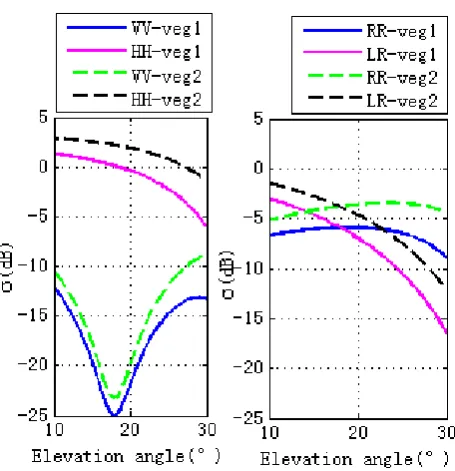
The effects of stem and leaf moisture contents on GPS multipath observables are investigated in this section. To demonstrate different wheat moisture content, we consider Veg 1 and Veg 2 for comparison (Table 2), with Veg1 having a moisture content a factor of 4 times higher than Veg2.
Table 2. Different vegetation moisture contents. The stem and leaf moisture contents of vegetation 1 and vegetation 2 are different. While the other input parameters are the same
Figure 5 shows the
final simulations. It can be seen that higher vegetation moisture content corresponds to lower magnitude fluctuations of GPS observables, which is due to the lower specular scattering cross sections at different polarizations for the entire set of elevation angles, as shown in Figure 6. The right hand panel of Figure 5 shows that lower vegetation moisture content corresponds to higher peak amplitude of spectral amplitude (especially for phase and code pseudorange). This means that changes of vegetation moisture content affects GPS observables, indicating that GPS-MR is an efficient technique for vegetation moisture content detections, and will be an effective supplement to the existing remote sensing techniques.
Vegetation1
Stem Leaf Moisture(gravimetric) 0.72 Moisture(gravimetric) 0.8
Vegetation2
Fig. 5 Effects of different vegetation moisture content on the forward GPS multipath simulation. The vegetation moisture content of veg1(vegetation 1) is higher than that one of veg2 (Vegetation 2). The moisture content (gravimetric) of stem and leaf for veg1 is 0.72 and 0.8, respectively, while the equipment for veg2 is 0.2 and 0.2,
Fig. 6 Specular scattering cross sections of different vegetation moisture contents. The left figure is for linear polarizations, while the right one is for circular polarizations. The vegetation moisture contents of veg1(Vegetation
1) is larger than the one of veg2 (Vegetation 2). The moisture contents (gravimetric) of stem and leaf for veg1 are 0.72 and 0.8, respectively. While the ones for veg2 are 0.2 and 0.2, respectively.
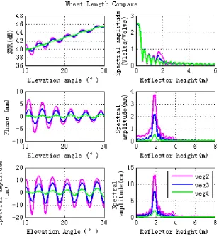
Vegetation height effects
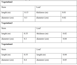
Table 3 Different vegetation sizes. as for vegetation 2, vegetation 3 and vegetation 4. the length and diameter of stem and leaf are different. while the other input parameters are the same
Vegetation2
Stem Leaf
length (m) 0.15 thickness (m) 0.01
diameter (cm) 0.3 diameter (cm) 0.02
Vegetation3
Stem Leaf
length (m) 0.35 thickness (m) 0.02
diameter (cm) 0.3 diameter (cm) 0.04
Vegetation4
Stem Leaf
length (m) 0.55 length (m) 0.04
Fig. 7 Effects of different vegetation sizes on the forward GPS multipath simulation observables. The lengths and diameters of the stems or the thicknesses and diameters of the leaves for Vegetation 2 (veg 2), Vegetation 3 (veg3)
and Vegetation 4 (veg4) are different. The sizes of veg2 are smaller than veg3, while the sizes of veg4 are largest. Results for varying wheat lengths are shown in pink (veg2), blue (veg3) and green (veg4). Lomb-Sargle
Fig. 8 Specular scattering cross sections of different vegetation sizes. The left hand figure is for linear polarizations, while the right hand figure is for circular polarizations. Lengths and diameters of the stems or thicknesses and diameters of the leaves for veg 2, veg3 and veg4 are different. The sizes of veg2 are smaller than veg3, while the sizes of veg4 are the largest.
Ground soil moisture effects
Table 4. Different ground soil moisture for veg 2 and veg5. As for Vegetation 2 and Vegetation 5, the ground soil moisture contents are different. While the other input parameters are the same.
Fig. 9 Vegetation scattering component contributions versus the specular incidence angles. The top panel is for linear polarization (VV and HH) and the bottom panel is for circular polarization (RR and LR). Total is the total scattering; Crown is the scattering from the crown layer; D-G is the Direct-ground scattering component; S-G is the specular scattering component.
Ground (volumetric soil moisture)
Vegetation 2 0.15
Fig. 10 Effects of different ground soil moisture contents on the forward GPS multipath simulation. The ground soil moisture content for veg2 is 0.15, while the one for veg5 is 0.55.
Fig.12 Scattering cross sections for S-G component with different ground soil moisture contents. The ground soil moisture content for veg2 is 0.15, while the one for veg5 is 0.55. The top panel is for linear polarization (VV and HH) and the bottom panel is for circular polarization (RR and LR).
Discussion
electromagnetic waves. The microwave vegetation model can be divided into a continuous model and the discrete scattering model, which is often used for crop physical scattering models. The discrete scattering model is often further divided into an incoherence model and a coherence model. The coherence model considers the changes of phase and amplitude, while the incoherence model only takes the intensity changes into considerations. The model is based on the radiative transfer equation model, while the bistatic scattering MIMICS (Michigan Microwave Canopy Scattering Model) is a commonly used vegetation scattering model. The limitation of our newly developed model is that it only takes amplitude changes into consideration. In this way, we think that the incident GPS broadcast signals are superimposed on the direct signals, and their phase remains changed. The superposition of the reflected signals only results in the amplitude change of electromagnetic waves. It has been pointed out that phase is very sensitive to soil moisture. As shown in Chew et al. paper (Chew et al. 2015), the GPS multipath metric is an efficient method for the vegetation amount estimation, but phase is not a good indicator. Therefore, this newly developed model only takes the amplitude change of GPS broadcast signals into consideration.
Conclusions
ground-based remote sensing technique for vegetation moisture content and growth detections. Using this model, it is more convenient to analyze the vegetation characteristics and it can explicitly link the GPS multipath signatures with the vegetation environment parameters. Our future work will concentrate on the development of algorithms for vegetation water content retrieval and the assessment of the potentialities of GPS-MR measurement for vegetation biomass monitoring.
Acknowledgement
This research is supported by the Natural Science Foundation of China (NSFC) Project (Grant Nos. 41501384, 41304002and 11173050).
References
Alonso-Arroyo A, Camps A, Aguasca A, et al. Improving the Accuracy of Soil Moisture
Retrievals Using the Phase Difference of the Dual-Polarization GNSS-R Interference Patterns[J]. IEEE Geoscience & Remote Sensing Letters, 2014, 11(12):2090-2094.
Chew C C, Small E E, Larson K M, et al. Effects of Near-Surface Soil Moisture on GPS SNR Data: Development of a Retrieval Algorithm for Soil Moisture[J]. IEEE Transactions on Geoscience & Remote Sensing, 2014, 52(1):537-543.
Chew C C, Small E E, Larson K M, et al. Vegetation Sensing Using GPS-Interferometric Reflectometry: Theoretical Effects of Canopy Parameters on Signal-to-Noise Ratio Data[J]. IEEE Transactions on Geoscience & Remote Sensing, 2015, 53(5):2755-2764.
Dobson M C, Ulaby F T, Hallikainen M T, et al. Microwave Dielectric Behavior of Wet Soil-Part II: Dielectric Mixing Models[J]. IEEE Transactions on Geoscience & Remote Sensing, 1985, GE-23(1):35-46.
Hallikainen M T, Ulaby F T, Dobson M C, et al. Microwave Dielectric Behavior of Wet Soil-Part 1: Empirical Models and Experimental Observations[J]. Geoscience & Remote Sensing IEEE Transactions on, 1985, GE-23(1):25-34.
Jin S, Komjathy A. GNSS reflectometry and remote sensing: New objectives and results[J]. Advances in Space Research, 2010, 46(2):111-117.
Larson K M, Nievinski F G. GPS snow sensing: results from the EarthScope Plate Boundary Observatory[J]. Gps Solutions, 2013, 17(1):41-52.
Larson K M, Small E E, Gutmann E, et al. Using GPS multipath to measure soil moisture fluctuations: initial results[J]. Gps Solutions, 2008, 12(3):173-177.
Liang P, Pierce L E, Moghaddam M. Radiative transfer model for microwave bistatic scattering from forest canopies[J]. Geoscience & Remote Sensing IEEE Transactions on, 2005,
43(11):2470-2483.
Masters D, Axelrad P, Katzberg S. Initial results of land-reflected GPS bistatic radar measurements in SMEX02[J]. Remote Sensing of Environment, 2004, 92(4):507-520.
Mccreight J L, Small E E, Larson K M. Snow depth, density, and SWE estimates derived from GPS reflection data: Validation in the western U. S.[J]. Water Resources Research, 2014, 50(8):6892–6909.
Nievinski F G, Larson K M. An open source GPS multipath simulator in Matlab/Octave[J]. Gps Solutions, 2014, 18(3):1-9.
Nievinski F G, Larson K M. Forward modeling of GPS multipath for near-surface reflectometry and positioning applications[J]. Gps Solutions, 2013, 18(2):309-322.
Rodriguez-Alvarez N, Camps A, Vall-Llossera M, et al. Land Geophysical Parameters Retrieval Using the Interference Pattern GNSS-R Technique[J]. Geoscience & Remote Sensing IEEE Transactions on, 2011, 49(1):71-84.
Small E E, Larson K M, Braun J J. Sensing vegetation growth with reflected GPS signals[J]. Geophysical Research Letters, 2010, 37(12):245-269.
Ulaby F T, Mcdonald K, Sarabandi K, et al. Michigan Microwave Canopy Scattering Models (MIMICS)[C]// Geoscience and Remote Sensing Symposium, 1988. Igarss '88. Remote Sensing: Moving Toward the, Century. International. IEEE, 1988:1009-1009.
Zavorotny V U, Larson K M, Braun J J, et al. A Physical Model for GPS Multipath Caused by Land Reflections: Toward Bare Soil Moisture Retrievals[J]. IEEE Journal of Selected Topics in Applied Earth Observations & Remote Sensing, 2010, 3(1):100-110.
Zavorotny V, Masters D, Gasiewski A, et al. Seasonal polarimetric measurements of soil moisture using tower-based GPS bistatic radar[C]// Geoscience and Remote Sensing
Symposium, 2003. IGARSS '03. Proceedings. 2003 IEEE International. 2003:781-783 vol.2.
Author Biographies
Xuerui Wu is an Associate Professor at Shanghai Astronomical Observatory, Chinese Academy of Sciences with focusing on GNSS-Reflectometry and its applications. She got the PhD in GNSS-R from the Dalian Marine University and worked as a post-doc at Shanghai Astronomical Observatory from 2012 to 2014, Shanghai, China.