DESERT 17 (2012) 105-109
Study of the Effect of Management Criterion on Desertification
Control (Case Study: Kashan)
M.S. Ziaei
a*, R. Masoudi
b, M. Ghodsi
c, H.Khosravi
da
Associate professor, Faculty of Management, Univ. of Tehran, Tehran, Iran
b
Ph.D. Student, Faculty of Natural Resources, University of Tehran, Karaj, Iran
c
Ph.D. Student, Faculty of Geography, University of Tehran, Tehran, Iran
d
Ph.D. Graduate, Faculty of Natural Resources, University of Tehran, Karaj, Iran
Received: 30 April 2012; Received in revised form: 18 July 2012; Accepted: 14 August 2012
Abstract
Desertification is more related to social and anthropogenic issues than natural causes and it becomes more important over the time. Human effects on desertification could be classified as direct and indirect factors. This study has focused on the effect of management factor, as a dominant case, on desertification of Kashan region based on IMDPA (IMDPA: Iranian Model of Desertification for Potential Assessment) model. The geometric average weight was used in order to find out the numerical value of management factor and then; desertification status map of the area was prepared using GIS. The results showed that about 59.96 percent of the region, based on management criterion, is classified in the medium class of desertification which mostly covers central, northern, southeastern and western parts of the region. Meanwhile, irrigation systems, rangeland ploughing and the index of evaluation implemented activity having the numeral value of 3.52, 3.43 and 2.23 are the most important affecting factors on desertification, respectively. Increasing unwise human activities due to lack of sufficient knowledge on new irrigation and cultivation technologies has been resulted on accelerated degradation and consequent desertification. Then, combination of new extension and traditional knowledge, policy making and planning may lead to desertification control in the region.
Keywords: Management; IMDPA model; Desertification; GIS; Kashan
1. Introduction
Physical issues such as soil salinity, alkalinities erosion as well as anthropogenic activities including over grazing, unwise irrigation and deforestation have been considered as the responsible factors of desertification in recent years (Darkoh, 1987). Soil and vegetation cover is a social and human-related phenomena which is, sometimes, more important than natural factors (Saadi, 2003). Anthropogenic factors have considerable effects on desertification. In a case study, it was revealed that, lack of proper management of
Corresponding author. Tel.: +98 21 66404795,
Fax: +98 21 66404795.
E-mail address:[email protected]
desertification.
One of the proposed methods to classify the desertification status is IMDPA model which enable the user to assign a numeral value for each sub factor of management for preparation of desertification map.
Vesali (2008) argues that pump age time of wells and crop yield have the highest and lowest effects on desertification in Kashan and Aran Bidgol regions, Iran. Abdi (2008) also concluded that desertification status of Abozeid Abad is in the metric level base on soil and waters factors of IMDPA model.
For better management and reducing desertification impacts, it is needed to implement proper strategies considering natural and human aspects (Mehrabi et al., 2010). Environment planning and policy making can play a major role in successful participatory management of natural resources (Lemos & Agrauwal, 2006). Rate of people participation is one of the effective factors in IMDPA model. In this research, all management and anthropogenic factors which affect on desertification based on IMDPA model were classified and rated.
2. Material and Methods
2.1. Study area
Kashan plain is located in 51° 05' to 51° 54' E and 33° 54' to 34° 23' N and has an arid climate with annual average precipitation of 133.5 mm. This region is in Isfahan province and south of Tehran with mean annual temperature of 18.8°C.
2.2. Methodology
In this research and based on IMDPA
methodology, rangelands and shrub lands were considered for policy making while agricultural lands were chosen to examine the effectiveness of management criterion (Tables 1 and 2). A range of 1 to 4 was assigned to each layer indicating its positive effect as 1 while lowest impact as 4 (Table 3).
Finally, weighted values of each index and sub index were mapped in GIS based on geometric average as follow:
Index- X=[(layer -1). (Layer – 2)…(Layer- n)]1/n
Where
Index-X: criteria
Layer: indices of each criterion N: number of indices of each criterion
According to the mentioned formulas, the following indices were calculated:
● Range land and shrub land index = (over grazing × shrubs cutting × range ploughing × yield reduction)
● Agriculture index: (Land use change × wise farming × unwise application of machinery and pesticides × irrigation × change of well to qanat)
● Policy and management = (Required actions × combating desertification methods × implemented activities × people participation)
● Management quality = (type and intensity of land use × policy and management)
3. Results
Based on the average weights of each land use (Table 4), it is clear that rangeland ploughing (3.43) and improper irrigation measures (3.52) have the highest scores in range and shrub land and agricultural land uses (Tables 4-5). Figures 1 and 2 show the landuse intensity in both landuses.
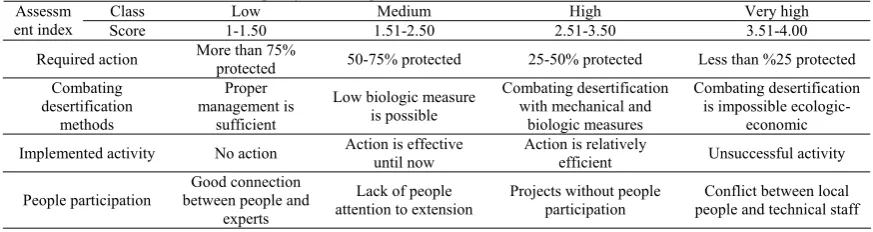
Table 1. Indices used for evaluation of policy and management
Very high High
Medium Low
Class
3.51-4.00 2.51-3.50
1.51-2.50 1-1.50
Score Assessm
ent index
Less than %25 protected 25-50% protected
50-75% protected More than 75%
protected Required action
Combating desertification is impossible
ecologic-economic Combating desertification
with mechanical and biologic measures Low biologic measure
is possible Proper
management is sufficient Combating
desertification methods
Unsuccessful activity Action is relatively
efficient Action is effective
until now No action
Implemented activity
Conflict between local people and technical staff Projects without people
participation Lack of people
attention to extension Good connection
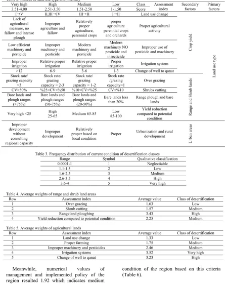
Table 2. Indices of land use type and intensity
Very high High Medium Low Class
3.51-4.00 2.51-3.50 1.51-2.50 1-1.50 Score
Assessment index Secondary factors Primary factors
IV II,IIIIV IIIII III Land use change
Lack of agricultural measure, no fallow and intense
plough Improper agriculture and fallow Relatively proper agriculture, perennial crops proper agriculture perennial crops and orchards Proper agricultural activity Low efficient machinery and pesticide Improper machinery and pesticide Modern machinery and pesticide Modern machinery NO pesticide and insecticide
Improper use of pesticide and machinery
Improper
irrigation Relative proper irrigation Relative proper irrigation irrigation Proper Irrigation system
>12 6-9 3-6 1-3 Change of well to qanat
Cr op yield Stock rate/ grazing capacity >3 Stock rate/ grazing capacity = 2-3
Stock rate/ grazing capacity = 1-2
Stock rate /grazing capacity=1
Over grazing
CV>50% %25<CV<%50 %10<CV<%25 CV<%10 Shrubs cutting Bare lands and
plough ranges (>75%)
Bare lands and plough ranges (50-75%)
Bare lands and plough ranges
(20-50%)
Bare lands less than 20%
Range plough and bare lands
Very high <25 25-65 High Medium 65-85 85-100 Low
Yield reduction compared to potential
condition Range and Shr
ub lands
L
and use type
Improper development without consulting regional capacity Improper development Relatively proper based on
local condition
Proper Urbanization and rural development
Urban areas
Table 3. Frequency distribution of current condition of desertification classes
Range Symbol Qualitative classification
0.0001-1 1 Neglectiable
1.1-1.5 2 Low
1.6-2.5 3 Medium
2.6-3.5 4 High
3.6-4 5 Very high
Table 4. Average weights of range and shrub land areas
Class of desertification Average value Assessment index Row Low 1.63 Over grazing 1 Medium 1.57 Shrub cutting 2 High 3.43 Rangeland ploughing 3 Medium 2.25
Yield reduction compared to potential condition 4
Table 5. Average weights of agricultural lands
Class of desertification Average value
Assessment index Row
Low 1.33
Land use change 1 Medium 1.75 Proper farming 2 Medium 2.46
Improper machinery and pesticides 3 Very high 3.52 Irrigation systems 4 High 3.23
Change of well to qanat 5
Meanwhile, numerical values of management and implemented policy of the region resulted 1.92 which indicates medium
condition of the region based on this criteria (Table 6).
Table 6. Average values of policy making and implemented management criteria in the region
Class of desertification Average value Assessment index Row Medium 1.93 Required action 1 Medium 1.90 Desertification measures 2 Medium 2.23 Implemented actions 3 Medium 1.51
Attention to people participation 4
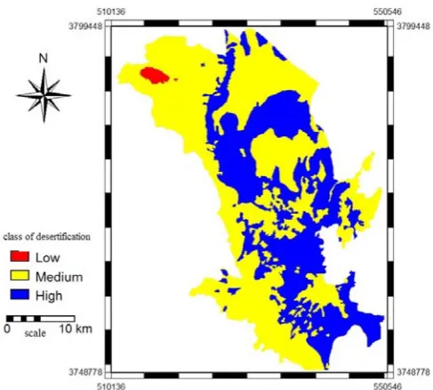
According to the prepared maps of indices, final map of desertification intensity based on
Fig. 1. Numerical value of range and shrub land type
Fig. 2. Numerical value of agricultural lands
According to figure 3, Kashan region is classified in three classing including 0.75 percent of the region in low class while 59.95% located in central, northern, southeastern and western party in middle class. It was revealed that 39.29% of the region has higher class of desertification mostly located in eastern and southeastern parts.
4. Discussion and Conclusion
Some factors in the region are responsible for unstable agriculture of the region including rangeland ploughing, improper irrigation, implemented activities and overuse of pesticides, these results confirms the same results done by Wang (2006), Vesali (2008), Ma (2007). Because of fine size particles of soil and water resources deficiency, flooding irrigation (especially in big sizes) is not recommended for this region because of high losses of water due to infiltration and evaporation which results in increasing trend of ground water depletion. Also in Aran and Bidgol areas, there are some bare lands with long term fallow which increase susceptibility of the land to erosion and land degradation. Higher intensity of pesticide application (up to 20 times) is shown in the farm lands which are resulted in higher numerical value of this index (2.23).
Proper land use planning, policy making and management strategies is required to this region in order to attract local people attention to participating in combating desertification projects (Carlsson & Berkes, 2005; Pretty and Ward, 2001; Ghorbani, 2011). On the other hand, lack of sufficient knowledge on application of modern irrigation techniques require extension measures considering indigenous knowledge of local people in planning and management of desertification.
Since land use change from rangelands to
farmlands is one of the problems of the region, then it is required to implement legal measures in order to prevent land use change which is important for controlling accelerated desertification (Saadi, 2003; Wang, 2006).
References
Abdi, J., 2008. Assessment and Mapping of Desertification condition using IMDPA model with emphasis on water and soil, (case study: Abuzeidabad), M.Sc thesis, Facalty of Natural Resources, University of Tehran.
Carlsson, L., Berkes, F., 2005. Co-management: concepts and methodological implications. Journal of Environmental Management, 75: 65–76.
Darkoh, M.B.K., 1987. Socio-economic and institutional factors behind desertification in Southern Africa, 19 1: 25-33.
Ghorbani, M., 2011. Trust and collaboration network in rangeland policy in Iran, 8th conference the
application of social network analysis, Zurich University.
Lemos, M.C., Agrawal, A., 2006. Environmental Governance, Annual Review of Environmental resources, 31: 297- 325.
Ma, Y., 2007, The temporal change of driving factors during the course of land desertification in arid region of North China: the case of Minqin county, Environ Geol, 51: 999–1008
Mehrabi, A.A., Ghorbani, M., Golkanian, A., Abnsham, E., 2010. Theory of watershed management in land management system (case study: Firdeh Watershed). Range and Watershed Management Journal, 64: 4: 529-541 (In Persian).
Pretty, J., Ward, H., 2001. Social Capital and the Environment. World Development, 29:2:209–227. Vesali. A., 2008, Biophysics indices of desertification intensity affected by human activities (study area: Kashan, Aran and Bidgol), M.Sc thesis, Faculty of Natural Resources, University of Tehran
Saadi, H., 2003. Extension measures for conservation of natural resources in Markazi Province, Ph.D. Thesis. University of Tehran, Iran (In Persian).