Effects of Wind Turbines on Radar:
A Pilot Study of US Concerns
Trisha Auld, B.Bus.
Masters of Science in Renewable Energy Dissertation
Energy Studies, School of Engineering and Energy, Murdoch University
Declaration
Except where I have indicated, the work in this dissertation is my own and has not been
submitted for assessment in another unit, or at another educational institution.
Abstract
A substantial number of wind energy projects have recently been stalled or abandoned in
the United States of America (US) due to concerns over the effects of wind turbines on
radar and military sites. The US Department of Defence (DOD) has reported that utility
class turbines can have a „significant impact‟ on the operational capabilities of air defence
radar, can interfere with military testing and training capabilities, and can obstruct
Comprehensive Test Ban Treaty monitoring (DOD 2006). The American Wind Energy
Association (AWEA) estimates 10,000 MW of wind generation capacity was held up or
abandoned in 2009 due to such concerns (cited in Warwick 2010).
This dissertation is a pilot project that aims to look behind such public statements to:
1. Define the nature of US concerns pertaining to the effects of wind turbines on radar and
military sites.
2. Determine the recent impact these concerns have had on wind energy projects in the
US.
3. Identify and analyse proposed solutions to the problem.
Results of the literature review, case study analysis, and industry interviews conducted for
this pilot study show:
1. Additional clutter, shadow, seismic noise and flight obstruction are the main concerns
the DOD has with proposed wind projects.
2. DOD concerns have had an extensive impact on the rapid development of the US wind
industry and could prevent the US from reaching its target of 20% of energy from wind
energy by 2030.
3. Proposed solutions available to overcome DOD concerns are vast; however the range
Acknowledgement
I would like sincerely thank those who have contributed to following dissertation. Thank you
to BP Wind Energy North America and Murdoch University for your generous financial
contributions; to David Van Hoogstraten of BP for your encouragement and time, to
Jonathan Whale and Trevor Pryor of Murdoch University for your sensible and calming
academic guidance; to Erich Von Dietze of Murdoch University for your considered and
helpful ethical steering; and finally to all the research participants who generously made the
Table of Contents
1. Introduction ... 1
1.1. Research Scope and Objectives ... 2
1.2. Research Methodology ... 2
2. Issue Context ... 4
2.1. US Wind Industry ... 4
2.2. US National Security ... 5
2.3. Turbine Impact Assessment Process ... 5
2.4. Fundamentals of Radar ... 6
3. Wind Turbines: US Causes for Concern ... 11
3.1. Why Wind Turbines Affect Radar ... 11
3.2. Effects of Wind Turbines on Radar ... 12
3.3. Effects of Wind Turbines on Military Sites ... 16
4. Impact of Concerns on US Wind Development ... 19
4.1. Scale of Impact Versus National Targets ... 19
4.2. FAA Assessment – A Catalyst for Delay ... 21
5. Issue Mitigations ... 26
5.1. DOD Approved Mitigations ... 26
5.2. Proposed Technical Mitigations ... 29
5.3. Evaluation of Proposed Solutions ... 38
6. Cooperation, Funding & Research ... 40
6.1. Cooperation ... 40
6.2. Research & Funding ... 42
6.3. Issue Next Steps ... 43
7. Evaluation of Pilot Study Results... 45
1.
Introduction
Wind energy is increasingly viewed as a viable option to expand renewable energy
generation in the United States of America (US). US installed wind generation capacity
accounts for 22% of the world‟s installed wind generation capacity (BP 2010), 2.3% of the
US energy mix (AWEA cited in Science Daily 2011), and grew more than any other US
energy source from 2008 to 2010 (BP 2010). The US Department of Energy (DOE)
envisions that 20% of the country‟s electricity could come from wind energy by 2030 (DOE
2008). To support this vision, the current US Government aims to double US renewable
energy generation by 2011 (Freshfields 2009) and supports wind energy development
through tax incentives and government grants under the American Recovery and
Reinvestment Act (ARRA) of 2009.
Despite strong growth in government support for the US wind industry, US wind energy
projects are being stalled by concerns from government defence departments over the
impact of wind turbines on radar and military sites. The US has a strong commitment to
national security, with a defence budget of over $650 billion (DOD 2011). The country‟s
policy on national security focuses on preventing acts of terrorism on American soil, and
fighting war in Afghanistan to disrupt and dismantle al-Qa‟ida (United States Government
2010). In serving this policy the US Department of Defence (DOD) has publicly advocated
that utility class turbines can have a „significant impact‟ on the operational capabilities of air
defence radar, can interfere with military testing and training capabilities, and can obstruct
Comprehensive Test Ban Treaty monitoring (DOD 2006).
The American Wind Energy Association (AWEA) estimated 10,000 megawatts (MW) of
wind generation capacity was held up or abandoned in 2009 in the US due to radar and
military site concerns (cited in Warwick 2010). Stu Webster (2010), speaking on behalf of
AWEA members, testified to Congress in 2010 that the growth necessary to achieve 20% of
US electricity from wind energy is unlikely to be achieved; without first resolving radar and
1.1.
Research Scope and Objectives
This dissertation is a pilot project that seeks to look behind such statements of concern to
understand:
What is the nature of concerns pertaining to the effects of wind turbines on radar and
military sites in the U.S?
How have radar concerns recently impacted wind energy developments in the U.S?
What solutions have been proposed to resolve such concerns and how valid are they
from a US wind development perspective?
What type of support (e.g. governance and funding) is required to help implement viable
solutions?
This pilot study is focused on solutions for the US. Examples of successful governance and
mitigations from alternative countries will be analysed for their suitability to the US.
1.2.
Research Methodology
This pilot project uses a synthesis of a literature analysis, case study analysis, and industry
interviews. The literature survey and case study analysis cover public information from
databases, news articles, wind/radar forums, and previous research. They aim to define
radar and military site concerns raised around wind turbines, identify any impact that
concerns have had on wind development in the US, and discover proposed solutions to
such concerns from the US and the rest of the world (where applicable). The case study
analysis aims to provide relevant examples from these areas.
The aim of the industry interviews is to enhance the findings of the literature survey by
What is required (e.g. governance and resources) to implement the most viable
solutions?
Note: Only non-classified information will be sought in these interviews
These questions may be tailored to include more detail questioning depending on the
expertise of the participant.
Eight individuals were invited to be interviewed. Participants were interviewed in a semi
structured manner over the phone, with a transcript of the interview being scribed
throughout. Answers to both scripted questions and conversational leads were recorded.
To ensure each interview was conducted in an ethical manner, guidance and ethical
approval (number 2011/043) was obtained from the Murdoch University Human Research
Ethics Committee for this research. Results of industry interviews will be presented under
2.
Issue Context
2.1.
US Wind Industry
The US has over 35,000 MW of installed wind energy capacity, with the potential to power
9.7 million homes, and avoid 62 million tonnes of carbon dioxide emissions annually (AWEA
2009). This shows rapid expansion from its installed wind energy capacity of 2,500 MW ten
years ago. Wind energy achieved an average growth of around 40% annually from 2004 to
2009 and at least 36 states now have utility class turbines installed (AWEA 2009), which are
typically over 400feet (ft) (122m) tall and 300ft (92m) wide (Warwick 2010).
The US does not have binding federal renewable energy targets (AWEA 2009); however
rapid wind energy development is strongly supported by the current government, which
aims to double US renewable energy generation by 2011 (Freshfields 2009). The current
government also supports the DOE‟s vision for 20% of US electricity supply to come from
wind by 2030 (also known as „20/30‟) and intensive state wind energy targets reinforce this
vision. In Massachusetts for example, the state government aims to have 2,000 MW of
installed wind power by 2020; an aggressive target considering Massachusetts only had
around 9 MW of installed wind energy capacity in 2009 (Butcher 2010).
Rapid industry growth has also been boosted by government incentives. Provisions in the
American Recovery and Reinvestment Act (ARRA) allow production tax credits (traditional wind development incentives) to be converted into an investment tax during the economic
downturn. Incentives for renewable energy research and manufacturing are also provided
under The Recovery Act. These government incentives supported around 3,000 MW of new
2.2.
US National Security
The US Department of Defense (DOD) is America‟s largest and oldest government
agency, with its headquarters at the Pentagon. The DOD manages a large inventory of
installations in over 5,000 different locations and utilises over 30 million acres of land
for its activities. The sites range from small half-acre single navigational aids to 3.6
million acre missile ranges (DOD 2010). The DOD website (2010) advocates:
“The national security depends on our defense installations and facilities being in the
right place, at the right time, with the right qualities and capacities to protect our
national resources. Those resources have never been more important as America
fights terrorists who plan and carry out attacks on our facilities and our people.”
For fiscal year 2012, a defence budget of $671 billion was been requested. This
includes a $553 billion discretionary budget to fund base defence programs and $118
billion for overseas contingency operations focussed on Afghanistan and Iraq (DOD
2010).
2.3.
Turbine Impact Assessment Process
The Federal Aviation Administration (FAA) in the US has the regulatory authority to review
and evaluate the impact of new structures on civilian and military airspace use (DOE 2008).
This impact assessment process is applicable to many new wind energy projects and is the
mechanism through which many wind developments have been held up, delayed or
abandoned. Wind projects are unable to start construction without FAA approval.
Wind farm developers are required to file a notice of proposed construction for each wind
turbine within a wind project that may affect the navigable airspace. This is defined in the
FAA Advisory Circular 70/7460 2K as:
Objects greater that 200 ft (61m) in height above the ground level at its location.
Objects within 20,000 ft (6098m) of a Public-Use or Military Airport or Seaplane Base
where object would exceed a 100:1 horizontal slope from the nearest point on the
Objects within 10,000 ft (305m) of a Public-Use or Military Airport or Seaplane Base
where the object would exceed a 50:1 horizontal slope from the nearest point on the
runway.
Objects within 5,000 ft (1524m) of a Heliport pad and the object would exceed 25:1
horizontal slope.
(FAA 2000)
Process guidelines also substantiate that developers are required to submit paperwork
stating the exact locations of the wind turbines 30 days before ground breaking (Magnuson
2010).
To determine whether a proposed construction is a potential hazard to air safety or security,
the FAA consults a number of relevant authorities, including the Department of Defence
(DOD) and the Department of Homeland Security (DHS). A notice of „no hazard‟ is issued
by the FAA when there are no concerns about air safety caused by a proposed
development. This enables a wind farm construction to commence from an air safety and
security perspective. Alternatively, the FAA issue a notice of „presumed hazard‟ when
consulted authorities raise concerns over air safety or security. Notices of presumed hazard
require wind developers to work in conjunction with the FAA and relevant authorities, in an
effort to minimise potential hazards (DOE 2008). At this point in the process many wind
development projects are delayed.
2.4.
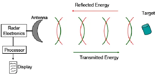
Fundamentals of Radar
2.4.1. Basic Radar Systems
the manner in which it is processed determines the basis of operation for a radar (DOD
2006).
Figure 1- Basic radar system
Source: (DOD 2006, 11)
There are two main forms of radar surveillance systems, primary and secondary. Primary
surveillance radar (PSR) uses the basic radar process above to provide a two or three
dimensional representation of a target in a region (DOD 2006). A number of factors can
affect a PSR‟s ability to process reflections off a target of interest, including; the power of
the transmitter, the distance from the target, the size of the reflection [or radar cross section
(RCS)] of a target, antenna geometry, obstructions, and reflections from other objects e.g.
hills, buildings, wind turbines (DOD 2006).
In contrast to a PSR, secondary surveillance radar (SSR) uses coded signals to obtain
information about a target. SSR systems are also called „beacon‟ systems and help air
defence staff distinguish between friendly and hostile aircraft. An SSR sends out a coded
signal which is received by aircraft. The aircraft‟s transponder translates the signal and then
transmits a coded signal back to the SSR (DOD 2006). This means SSR systems use
much stronger direct signals from an aircraft‟s transponder, rather than weaker reflected
signals used by a PSR. Consequently, SSR are typically unaffected by reflections from
other objects (DOD 2006); an important point for understanding the impact of wind turbines
on PSR and SSR.
2.4.2. Types of Radar Used in the US
The following section outlines radar types used by the DOD, FAA, and National Oceanic
relatively aging radar fleet with around 80% of all US radars being implemented from the
1950s to 1980s.
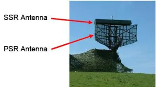
Air Traffic Control Radar (ATC)
ATC radars consist of both primary and secondary radar systems and are used to monitor
aircraft in and around air fields. Modern ATC radars typically have PSR coverage of up to 60
miles and SSR coverage of up to 120 miles
(Raytheon 2011). There are 283 ATC radars of
various models in the US. 110 are modern digital
ASR-11 (deployed in the 1990s), 135 are ASR-
10 (deployed in the 1980s) and 38 are
Figure 2 - UK Watchman ATC Radar
Source: DOD 2006, 19, Figure 11
analogue ASR-8 (deployed in the 1970s) (NWCC 2010). The figure above shows an
example of an ATC radar with the PSR and SSR identified.
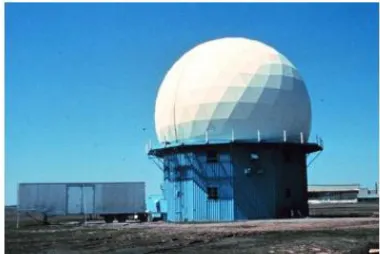
Long Range Radar (LRR)
LRR (shown below) are described as the “back bone of primary surveillance in the US”
(Blackman cited in NWCC 2010, 24). LRR track aircraft in between airports and
Figure 3 – ARSR-4 Radar
Source: Aftergood 2000
Are used for air defence (Brenner et al 2008). Modern
systems are digital, and provide coverage up to 250
nautical miles (nmi) (Aftergood 2000), while older
systems are analogue (Seifert 2009). There are 128 long
range radars of various model types in the US (NWCC
2010); these are predominantly located in perimeter
states (Aftergood 2000). Two dimensional FPS-20, ARSR
Weather Radar
There are 158 WSR-88D Next Generation
Weather Radars (NEXRAD) in the US
which are used to monitor weather
conditions. The majority of these were
deployed in the late 1980s (NWCC 2010).
These radars create Doppler maps to
illustrate rain, hail, and snowfall patterns
(DOD 2006). The figure to the right shows
US NEXRAD radar.
Figure 4 - US NEXRAD Weather Radar
Source: DOD 2006, 21, Figure 13
Missile Early Warning Radar (EWR)
EWR (shown below) are large, high powered phased array systems designed to detect and
track objects with low radar reflectivity at long ranges with a high level of accuracy. These
radars have a range in excess of 5,000 kilometres (km) and are required to discriminate
Figure 5 - US Beale Early Warning Radar
Source: DOD 2006, 20, Figure 12
between closely spaced objects; such as
nuclear weapon re-entry vehicles and
possible counter measures designed to
confuse defensive systems. There are two
EWR radars in the US, one on the east
coast in Massachusetts and another on the
west coast in California. (DOD 2006).
2.4.3. Target Detection
Auld (2006) describes electromagnetic energy as „fairly indiscriminate in what it reflects off‟
(5). Therefore ATC radar and LRR adopt particular processing techniques to distinguish
between the electromagnetic echo of aircraft and the echoes of unwanted targets, referred
to as „clutter‟. Examples of clutter include objects such as buildings and towers (Kelly 2011).
The parameters radar use to identify aircraft from clutter are described by Kelly (2011)
below:
1. Aircraft have a high level of reflectivity, known as a radar cross section (RCS). Radars
2. Aircraft occupy predictable elevations. Radar antennae can be oriented to focus on
echoes from a particular elevation.
3. Aircraft are in motion at the moment they reflect electromagnetic energy causing an
apparent change in frequency of the return, also known as a „Doppler‟ effect (Wolff
2011). Radars can use moving target indication (MTI) and moving target detection
(MTD) to differentiate and focus on echoes from moving targets, cancelling out
stationary objects.
4. Aircraft do not hover or remain still for extended periods of time. Constant false alarm
rate (CFAR) processing can be used to determine the average background echo per
cell of radar coverage. Amplitude thresholds can then be used to only pick up objects
with echoes above that of the background average.
RCS thresholds, antennae orientation, MTI/MTD processing, and CFAR processing are all
minimum standard for most modern radar (Kelly 2011). Weather radar uses similar
parameters to distinguish between actual and unwanted weather echoes (EURMETNET
3.
Wind Turbines: US Causes for Concern
3.1.
Why Wind Turbines Affect Radar
Wind turbines affect radar as their echo characteristics often match those of an actual
aircraft or storm pattern, which radar seeks to track. For example:
Wind turbines have incredibly high reflectivity. Studies conducted by the DOD (2006)
showed that the RCS for a turbine could be greater than that of a long haul, wide bodied
aircraft such as a 747. Therefore RCS filters have difficulty in differentiating wind
turbines from aircraft. The following figure illustrates the RCS of a 1.5MW wind turbine
against other objects that may be detected or rejected by radar.
Figure 6 - Comparison of RCS for different objects
Source: DOD 2006, p15
Utility scale wind turbines can occupy similar elevations to aircraft, especially when
located on hill tops. Radar requirements to monitor low flying aircraft means wind
turbine and aircraft can share the same elevation (Kelly 2011). Therefore typical
Wind turbine blades are moving at the time of reflection, meaning that typical MTI/MTD
algorithms are unable to detect the difference between a turbine and an aircraft (Kelly
2011).
Wind turbine echoes can vary over time depending on wind direction and blade
orientation. This causes problems for CFAR processing as wind turbines can cause
consistently high background echoes which can raise the CFAR threshold. This means
smaller aircraft, with a lower RCS than a turbine, may not be detected. Additionally,
radar may treat inconsistent large returns from turbines as actual aircraft targets (Kelly,
2011).
Based on the information above, typical processing methods used by radar to focus on valid
targets can be ineffective at filtering out the unwanted echoes or „clutter‟ caused by wind
turbines.
3.2.
Effects of Wind Turbines on Radar
Wind turbines cause two main types of interference with radar, direct interference and
Doppler interference. Direct interference is caused by the high reflectivity of the turbine
components: towers, nacelles, and blades. This can reduce the sensitivity of the radar via
increased background noise, create false readings, and shadow areas of radar coverage.
Alternatively, Doppler interference is caused by the moving blades of a turbine which can
cause false targets, false MTI/MTDs, and impacts both airborne and fixed radar (Seifert
2009). The following section explains each of these impacts in more detail. A variety of
research has been conducted which verifies the following impacts of turbines on ATC, LRR,
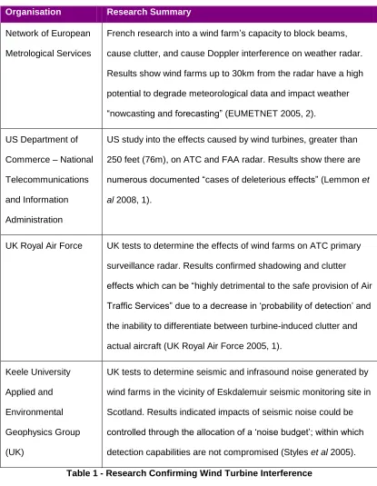
Organisation Research Summary
Network of European
Metrological Services
French research into a wind farm‟s capacity to block beams,
cause clutter, and cause Doppler interference on weather radar.
Results show wind farms up to 30km from the radar have a high
potential to degrade meteorological data and impact weather
“nowcasting and forecasting” (EUMETNET 2005, 2).
US Department of
Commerce – National
Telecommunications
and Information
Administration
US study into the effects caused by wind turbines, greater than
250 feet (76m), on ATC and FAA radar. Results show there are
numerous documented “cases of deleterious effects” (Lemmon et
al 2008, 1).
UK Royal Air Force UK tests to determine the effects of wind farms on ATC primary
surveillance radar. Results confirmed shadowing and clutter
effects which can be “highly detrimental to the safe provision of Air
Traffic Services” due to a decrease in „probability of detection‟ and
the inability to differentiate between turbine-induced clutter and
actual aircraft (UK Royal Air Force 2005, 1).
Keele University
Applied and
Environmental
Geophysics Group
(UK)
UK tests to determine seismic and infrasound noise generated by
wind farms in the vicinity of Eskdalemuir seismic monitoring site in
Scotland. Results indicated impacts of seismic noise could be
controlled through the allocation of a „noise budget‟; within which
detection capabilities are not compromised (Styles et al 2005).
Table 1 - Research Confirming Wind Turbine Interference
To better understand the nature of US DOD concerns, the DOD‟s 2006 report ‘Effects of
Wind Farms on Military Readiness’ which also confirms turbine interference effects will be
referenced extensively in the following sections.
3.2.1. Shadowing & Clutter
Shadowing
The DOD (2006) describe the shadowing effect wind turbines have on radar in the following
way:
“Objects in the path of an electromagnetic wave affect its propagation
characteristics. This includes the actual blockage of wave propagation by large
individual objects or interference in wave continuity due to diffraction of the beam by
individual or multiple objects“ (DOD 2006, 13-14)”
The following figures illustrate complete and partial blocking of electromagnetic waves and
diffraction of electromagnetic waves. Clusters of wind turbines typically cause diffraction of
a radar‟s electromagnetic energy and therefore create shadow zones or blind spots where
monitoring is less efficient. The amount of shadow incurred will be dependent on the size of
the wind farm and the topographical features which surround it.
Figure 7 – Shadowing
Source: DOD 2006, 14 Source: DOD 2006, 14 Figure 8 - Diffraction
Clutter
DOD (2006) advocate that „clutter‟ could occur if any portion of the turbine appeared in the
radar‟s line of sight and exceeds accepted RCS noise thresholds. Studies conducted by the
DOD (2006) showed the RCS for a turbine could be greater than that of a long haul aircraft.
As wind turbines are stationary and near the surface of the earth, this appears as „clutter‟ on
air defence radar. The amount of clutter is in direct proportion to the number of turbines
within the line of sight of the radar. The DOD (2006) study concluded that a single turbine
located at a distance from the radar will have minimal impact; however a large number of
turbines over a wide sector of the radar‟s coverage will significantly impact its performance.
This is supported by Ministry of Defence research trials in the United Kingdom.
Impacts of Shadow and Clutter
When asked about efforts to improve the range of technical mitigations available to
overcome wind/radar issues, the Wind and Radar Expert interviewed by the author
explained, “There is military concern around the use of wind farms (clutter and shadow
zones) by unfriendly aircraft to transition below the radar level of detection.” Thereby
allowing unfriendly aircraft to conduct missions undetected. The Wind and Radar Expert
extended his answer to say that drug trafficking was an area of military concern for such a
manoeuvre. Magnuson (2010) suggests this DOD concern also pertains to pilots who have
hijacked a plane. Schleck Associates (2010) suggest clutter and shadow zones could make
it hard to maintain security for potential terrorist targets. The DOD (2006) highlight that
shadow and clutter areas may minimise the tie that security forces have to react to potential
threats.
An interview with a Military Pilot with US experience conducted by the author confirmed that
it is possible for drug traffickers to have the appropriate flight equipment to fly below the
radar (e.g. helicopters or jets). When asked about the feasibility or terrorists or drug
trafficker having access to such assets the Military Pilot said, “It‟s absolutely plausible. Drug
traffickers looking to move product across US borders have been known to use
submarines. Having access to a jet is definitely not out of the question.” In considering this
option the Military Pilot added “An important consideration is the distance between the take
off point, the wind farm, and potential targets”pointing out that different aircraft types would
have different refuelling requirements and therefore different capacities to complete such a
Theoretically, the inability of a radar operator to track an aircraft for a short period over and
near wind farm is therefore a valid concern. Presumably proposed wind energy sites near
potential terrorist targets or near potential trafficking entry routes would therefore have lower
acceptance for loss of coverage. The DOE (2008) website however points out, “Wind
developers have successfully installed over 21,000 megawatts of wind power capacity
across the US and 93,000 megawatts across the world in the past 20 years without one
documented case of enabling an attack on any nation.” This leaves the question open as to
how significant this theoretical threat is.
Shadowing and clutter also affect weather radar. The Forth Worth Star (2010) reported that
clusters of turbines near Albany in the US produce radar shadows to the north and west of
Dyess. These shadows are of concern as they could potentially hide the appearance of
severe weather approaching a base. Butcher (2010) describes how a wind turbine at the
Jimney Peak ski resort in Hancock produces a signature resembling a thunderstorm, which
cannot be distinguished from heavy rainfall. Kalinowski (2010, cited on www.faa.gov)
explains how the false appearance of storm activity on Next Generation Weather Radar
(NEXRAD), caused by wind farms, makes it hard to provide accurate weather information to
pilots; therefore decreasing the accuracy and safety of weather forecasts.
While the pilot study results indicate shadow and clutter have adverse affects on radar, is
there an acceptable level of interference for radar? From an interview conducted by the
author with a Wind and Radar Expert it was found that “Just because a radar can see a
turbine, that doesn‟t mean the radar cannot do its job. The aviation industry is of the view
that a little bit of sparkle is manageable, while the military are concerned with any loss of
airspace, test ranges, and training ranges used by the US military can occupy the same
altitude as aircraft. Wind turbines can be over 400ft tall (122m) (Warwick 2010) and military
flight training missions can be as low at 10ft (3m) (obtained from author‟s interview with a
Military Pilot); meaning wind turbines can physically obstruct low flying missions or aircraft
during take off and landing.A representative of Dyess Air Force Base in Abilene, where
more than 2,000 turbines have been built within a 100 mile radius, advocated that wind
turbines could pose hazards for B-1 bombers and C-130 transports used in the area. Base
officials also found wind farms in West Texas interfered with low attitude training missions
that can extend up to 120 miles from the base (Fort Worth Star 2010). The DOD (2006)
highlights that a single turbine poses the same aviation obstruction as radio antennas and
cell phone towers, and as such could be mitigated through the same process; however the
number and proximity of turbines being installed makes them harder to mitigate with
traditional measures.
Overhead transmission lines associated with wind farms also provide a flying hazard for
aircraft, which poses a safety risk to flight and weapons training operations (DOD 2006).
From the interview conducted by the author with a Military Pilot with US experience, it was
confirmed that: “Both the poles and the lines provide obstacles to aircraft. The lines are
particularly hard to see while using night vision equipment”. The Military Pilot added when
asked about the validity of such concerns, “There have been many aircraft accidents due to
wire strike. They‟re definitely a concern for pilots on low flying missions”. Flight training and
testing concerns however, are likely to be restricted to only particular areas of the US. Tom
Vinson, a spokesperson for AWEA who was interviewed by the author, said “There‟s a
limited number of training areas in the US for such DOD activities. Issues around training
areas primarily come from Nevada, California, and Texas.” Vinson said when questioned
around the split between objections due to military sites versus radar.
3.3.1. Seismic and Infrasound Noise
Seismic and infrasound noise is the final publicly stated area of concern for military
operations. Wind turbines produce seismic and infrasound noise that could “contaminate
monitoring stations providing data to support the Comprehensive Test Ban Treaty (CTBT)
and US nuclear explosion monitoring effort” (DOD 2006 Appendix 2, 61). There are 4
Detection Systems located in the US. These systems use a seismometer array to monitor
nuclear explosions in line with the CTBT (DOD 2006). Studies by Styles et al (2005) confirm
that sophisticated equipment such as seismic arrays can detect seismic noise caused by
wind turbines.
Interference with military design and development sites was also confirmed as a viable
concern. A Wind and Radar Expert interviewed by the author said, “A wind turbine changes
the environment meaning there isn‟t the same baseline for testing from one day to the next.”
The Expert said when commenting on efforts to increase the range of viable technology
solutions. These results are confirmed by seismic noise tests conducted in the UK at the
Eskdalemuir; however these tests also pointed out that only the most sophisticated
4.
Impact of Concerns on US Wind Development
4.1.
Scale of Impact Versus National Targets
In 2009 10,000 MW of proposed wind energy generation capacity was delayed in the US
(AWEA, cited in Warwick 2010). From interviews conducted by the author with Tom Vinson
from AWEA, it was revealed the approximately another 10,000 MW was delayed in 2010
and that no data had been collated for 2011. The following impact map presented by Seifert
(2009) shows existing wind projects (in blue) and proposed wind projects affected by radar
interference issues (in purple) against radars used by the DOD (in red). This map
demonstrates that numerous projects, many of substantial MW size, are affected by this
issue.
Figure 9 - Impact Map 2009
Source: Seifert 2009
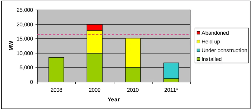
The overall impact for the US wind industry is outlined in the following figure, which shows
delayed wind capacity and implemented wind capacity against the growth forecast required
0 5,000 10,000 15,000 20,000 25,000
2008 2009 2010 2011*
Year
MW
Abandoned
Held up
Under construction
Installed
Figure 10 - Issue Impact: MW Installed v.s. DOE 20% 2018 Target
Source: (Graph data sourced from AWEA (2011, 2010, 2009, 2008), interview with Tom Vinson (2011), AWEA (cited in Warwick 2010), and Blackman (2009)). Notes: Dashed red
line represent ‘20/30’ target installation, * 2011 first quarter data only, ‘Held Up’ and ‘Abandoned’ information available for 2009-2010 only.
The above figure indicates a significant amount of wind development has been held up in
the US in recent years. Recent wind energy implementation falls well below the „20/30‟
target capacity required to be obtained by 2018 (shown by the dashed line). Based on this
comparison, it appears this impact could prevent the US wind industry from meeting the
„20/30‟ target without a rapid increase in wind energy implementation. This is reinforced by
the following figures which show „20/30‟ target wind energy installation and wind energy
Figure 11 - 2030 vision for wind energy development
Source: Seifert 2009
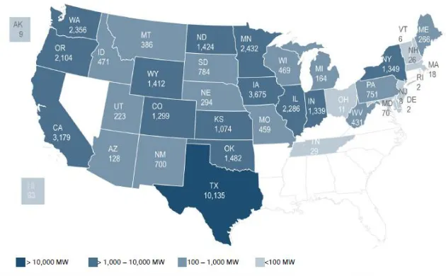
Figure 12 - US Wind Power Capacity Installations by State (2011)
Source: AWEA 2011,6
4.2.
FAA Assessment – A Catalyst for Delay
A review of the literature indicated the existing FAA process for the notification and review
of proposed wind farm constructions appears to suffer inefficiencies related to timing and
cooperation. In 2010 the Deputy Undersecretary of Defence for Installation and
Environment, Dorothy Robyn, voiced concern that wind developers were notifying the FAA
Ms Robyn identified that late notification limits the scope for collaborative efforts to identify
potential issues and mitigation options (cited in Magnuson 2010). Alternatively, Levitan
(2010) shows how input from government agencies has been uncoordinated and also last
minute. This is demonstrated in Caithness Energy Shepherd‟s Flat wind development
project, summarised in the case study below.
Case Study – Shepherd’s Flat Wind Energy Project.
Shepherd‟s Flat is a 909 MW wind farm, proposed by Caithness Energy to be built in
northeast Oregon (Levitan 2010).The project is set to be the largest wind farm in the world
(Eilperin 2010). It involves a 1.4 billion US dollar turbine deal with General Electric (Learn
2010), is expected to avoid over 1.2 million tonnes of greenhouse gas emissions per year,
and will create over 400 construction and 35 permanent jobs (Coal Geology 2010) in an
economically depressed community (Eilperin 2010). By 2010 the project had been in
Figure 13 – Shepherd’s Flat Project
Source: Washington Post (2010)
development for almost nine years (Eilperin
2010). Caithness had been through more
than four years of permit approval with
county, state and federal governments, and
had worked out concerns with the US Navy.
Despite being notified of the project 3 years
earlier (Air Force Times 2010), the US Air
Force raised concerns „at the 25th hour‟
about the turbines‟ potential to create further
clutter and aircraft tracking interference
issues for the long range Fossil radar at Ore, over 70 miles away. This denied the project its
final FAA permit required for construction (Eilperin 2010). If construction was not completed
General Electric officials also lobbied the White House; with Wyden using his nomination for
future DOD staff as a bargaining tool to help ensure the issue was resolved. Merkley‟s
Press Office (2010) reported that after „a months long stand off‟ the Pentagon announced it
would no longer block the project and would instead upgrade the nearby radar system,
improving its ability to cope with clutter. A move that would „eliminate the threat to other
planned wind farms in the area‟.
The lack of coordinated consultation for affected agencies was further highlighted by Tom
Vinson, a representative of AWEA, who advocated (in an interview with the author) that
vigilant wind developers attempt to engage relevant military input as soon as possible.
Vison said when commenting on the „next steps‟ required to progress the issue. Vinson also
commented that military departments are not always responsive and collaborative efforts to
identify and resolve hazards can be inconsistent (cited in Magnuson 2010). The lengths to
which wind developers can be prepared to go to in order to avoid such issues is reinforced
by claims from Kalinowski (2010) that primary FAA radar leaseholders have been offered
financial incentives from wind developers not to renew their FAA contract and to lease to
wind developers instead (cited on FAA website 2010).
4.2.1. Inhibiting Concerns – Science or Politics?
The congressional battle required to progress the Shepherd‟s Flat wind project, opens
questions about the extent to which radar and military site concerns are genuinely scientific
and to what extent they are political. Iberdrola Renewables, another company with wind
developments in the Shepherd‟s Flat area, revealed that when radar issues have been
raised in the past developers have been helped by Congress members, who are keen to
bring employment to the area (cited in Levitan 2010). This political intervention would
appear to override the scientific intention of the FAA impact assessment. This overriding
can be interpreted in various ways:
1. Genuine DOD concerns may be being superseded by political agendas for economic
development. The extent of political intervention required in the Shepherd‟s Flat case
2. DOD concerns may be less scientific and more political than publicly advocated. Recent
military base closures may be a potential motive for preserving current base
environments. Watson (2010) reports that 20 major military installations will be shut
down by 2011 under the DOD Base Closure Alignment Commission. Watson (2010)
recognises that base closure can have a negative economic impact in rural
communities reliant on military business and employment. Based on this information it
could be possible that wind turbines, which have the potential to degrade radar
coverage and military sites, could be objected to in order to preserve the quality of base
facilities and therefore help prevent a base from being selected for closure.
In evaluating the contrasting agendas of rapid wind development and national security,
Seifert (2006) argues the issue matters when wind farms pose an unreasonable risk to
national security and the benefits offered by the wind farm do not outweigh their interference
impact. Providing an objective assessment of this balance, which is supported by Congress,
remains a current challenge for the FAA impact assessment process.
4.2.2. DOD Energy Siting Clearing House
Tom Vinson, an AWEA spokesperson interviewed by the author, said the DOD has taken
measures to improve the FAA impact assessment process (when asked about
inefficiencies in the FAA assessment process). Vinson stated that the DOD have
reorganised how they engage with wind developers, “Under Section 358, fiscal year 2011,
of the National Defence Authorisation Act, they have developed a one-stop-shop for
developer engagement called the Department of Defence Energy Siting Clearing House…
The Clearing House has been methodically going through the backlog of development
applications and sorting them out” Vinson said. The new process has been thought to be a
Tom Vinson also pointed out, when interviewed by the author, “There are still some issues
with individual services not being as collaborative as the Clearing House, however overall
we‟ve received positive feedback... People feel like they have access and their concerns
are being heard”. While these changes appear to improve some of the issues related with
the FAA process, whether the Clearing House is able to provide an objective justification for
concerns that lead to a balanced assessment of the impact against the benefits of wind
energy proposals is an important question. A spokesperson from the Clearing House was
invited to be interviewed by the author to discuss this topic, however the spokesperson was
unable to participate due to a busy schedule.
5.
Issue Mitigations
Wind industry participants acknowledge there is no single solution to radar and military site
concerns due to variables such as: location, radar type, mission type, and terrain type in
each proposal (Magnuson 2010). The following section outlines DOD approved and
proposed mitigating solutions to the issue.
5.1.
DOD Approved Mitigations
The DOD in ‘Effect of Windmills on Military Readiness’ (2006) concluded non- technical
solutions to be the only proven mitigation to avoid the degradation of radar capability and
interference with military training due to wind turbines. Non- technical solutions involve
avoiding placing wind turbines in a radar‟s line of sight via zoning, terrain masking or terrain
relief.
5.1.1. Zoning
Zoning refers to placing turbines a predetermined distance from a radar to avoid
interference. The aforementioned DOD report (2006) recommends a distance of 30 nautical
miles (nmi) would be required for turbines with blade tips that protrude over 300 ft (91m)
above the local terrain. Zoning is a mitigation supported by policies pertaining to wind
turbine siting in many European countries. In Austria, wind farms greater than 10km from an
air defence radar will receive no objections. In The Netherlands, only wind farms within 15
nmi (approx 24 km) from a military radar require review. In Germany, policy enforces a
protection zone of 10km around all ATC radars, with an area of interest up to 18km from
ATC radars. These policies address military and civilian concerns over radar shadowing (for
Germany and the Netherlands), electromagnetic interference and obstacles to low flying
Zoning is also a technique that has been used to overcome seismic noise interference for
nuclear explosion monitoring in the UK. Studies in Eskdalemuir in the UK, site of the longest
operating seismometer array and very good wind development areas, found that turbines
within 10km of nuclear monitoring sites should be prohibited (Styles et al 2005). From 10km
to 50km, the study concluded that wind turbines should not exceed a predetermined „noise
budget‟, and turbines over 50km from the radar should have no restrictions applied
pertaining to this monitoring type (Styles et al 2005). The method used to determine these
protocols has been accepted as sound by the DOD (2006) at which time recommendations
were made for similar testing in the US, on a site to site basis to allow for differing
background seismic noise.
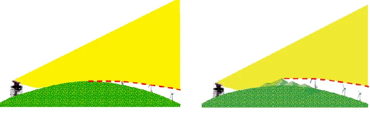
5.1.2. Terrain Masking and Relief
Under UK, US and European policies mentioned in the previous section, turbines may be
placed closer to the radar after further analysis determines there are no effects or the
effects can be suitably mitigated. Non-technical solutions to facilitate this include ensuring
there is elevated terrain between the radar and the turbine (terrain masking) or ensuring the
elevation of the radar is above that of the turbine (terrain relief) (DOD 2006). The following
figure illustrates how terrain masking helps remove turbine interference on a radar system.
Kelly (2011) also identifies terrain masking as the “simplest method of mitigation” (17).
No terrain masking – majority of turbines in
radar line of sight
Some terrain masking – less turbines in
radar line of sight
Figure 14 – Illustration of Terrain Masking
Analysis using wind farm models and terrain databases is required to determine whether
this mitigation is suitable for a particular wind farm. The DOD (2006) advocate that while the
analysis is not complicated it can be time-consuming.
5.1.3. Viability of DOD Approved Solutions
The practicality of using zoning alone can be limited due to the vast distribution of US radar.
Seifert (2009) highlights this through the following figure which displays recommended
turbine siting areas (in green) based on radar location (red zones indicating a 20nmi buffer
zone).
Figure 15 – Recommended Turbine Siting Areas
NWCC 2010); representing an opportunity cost that could be considerable. Alternatively,
Kalinowski (cited on www.faa.gov 2010) suggests moving the radars to facilitate zoning is
an impractical option. Additional radars may be added, but existing coverage cannot be lost.
The FAA does not have a stock of spare radars and new radars would require a change in
national airspace systems e.g. reporting points and airspace fixes.
Brenner et al (2008) argues non-technical solutions alone are narrow-sighted, stating the
2006 DOD report favoured to “block the installation of offending turbines, rather than to
attempt to find technical means of ameliorating the turbine impact” (4). The following
section explores a range of technical solutions that have been proposed to help solve the
issue.
5.2.
Proposed Technical Mitigations
Kelly (2011) suggests, where non-technical mitigations such as terrain shielding are not
possible, there are three theoretical ways to limit the impacts of wind turbines on radar:
Improving radar design to enable radars to distinguish between wind turbines and
actual targets e.g. radar upgrades, gap fill radar.
Reduce the reflectivity of the turbine e.g. via stealth technology to reduce the turbine‟s
RCS.
Remove the clutter from the radar‟s vision, e.g. blanking or suppressing of radar cells
where turbines are known to be.
The following sections discuss current and future technologies that have been suggested
for the US market.
5.2.1. Radar Upgrade
Radar upgrades are pertinent to the US due to the aging nature of the US radar fleet. Ken
Kingsmore from the DOD (cited in NWCC 2006) explains that prior to September 11, 2001
the Joint Radar Planning Group in the US, who manage long range radar assets, focused
primarily on maintaining border sites such as Hawaii, Alaska and Guam; leaving internal
radars to remain untouched. After the September 11 terrorist attacks however, the group
became more inwardly focused adding 170 additional sites covering mainland US. Few
highlights that, due to their age, many current FAA radars have limited capability to filter out
clutter. In addition, making adjustments to older radars, e.g. reducing their sensitivity to
eliminate clutter, can cause actual targets to be missed.
Gary Seifert, an expert in radar and wind at the Idaho National Laboratory, advocates
modern radars are better equipped to deal with turbine impact issues than older radars
(cited in NWCC 2006). Modern radars are typically digital (versus analogue) and have a
greater band width, which Webster (2010) arguescan improve the radar‟s resolution and
ability to track targets between turbines.New radars also include digital processing
capabilities such as multidimensional detection, and pulse shapes which can help
differentiate between aircraft and wind farms (Brenner et al 2008). Brenner et al (2008)
point out that computing power has increased 600 fold since the 1990s. The older systems
are often hard wired and unable to be changed, limiting their flexibility.
Modern radars that have been shown to improve aircraft detection and/or reduce the
visibility of wind farms include the Raytheon ASR-11 (produced in Canada) and the UK
equivalent, the Lockhead Martin TPS-77, which enable the UK Ministry of Defence to lift
objections to over 3,000 MW of offshore wind projects (Webster 2010). A Wind and Radar
Expert interviewed by the author advocated “Lockhead TPS 77 is a fabulous radar that is
designed to provide advanced targeting and coverage for the military… Published limits (for
the radar) indicate it can provide coverage as close as 500m to the edge of the wind farm.”
Tom Vinson, an AWEA spokesperson interviewed by the author, said the DOD has
replaced an old ASR-8 with an ASR-11 at Travis Air Force Base. Vinson stated in the
interview that “The DOD are not comfortable to say they validate these mitigations”
however, “they would agree this has improved coverage”. Vinson also said in the interview
Although each of these modern systems has a greater ability to manage the effects of wind
turbines, at present no radar is capable of distinguishing a wind turbine echo from a valid
aeroplane target echo and therefore no system can consistently provide un-degraded
coverage in the area of wind farms (Kelly 2011). This view was supported by the Wind and
Radar Expert interviewed by the author who said:
“You can not completely eliminate clutter. New software allows you to track… right up
to the edge of a turbine and then pick it up right after the turbine, therefore reducing
the size of areas without coverage… Raytheon‟s ASR11 is very effective at reducing
zones with poor visibility to one or two (radar) cells either side of a turbine.”
Geoff Blackman, a consultant on wind radar issues for Westslope Consulting, recommends
older US ATC radars such as the ASR-8 (38 in US) and ASR 9 (135 in US) radars should
be considered for replacement with ASR-11 radars (cited in NWCC 2010, p25) due to their
improved „clutter‟ processing capability. Blackman added that some of the newer radars
already installed might cope with wind farm interference through additional software
upgrades. Tom Vinson, an AWEA spokesperson interviewed by the author, said
“The only issue (for radar upgrades) is cost. A Lockheed radar is in the vicinity of $15 - $20
million and is not going to be viable everywhere; particularly for single developer projects.
Only areas with multiple developer interests will, most likely, be able to afford such a cost.”
5.2.2. Software Upgrades
The following software upgrades can be added to modern radars or digitised older radars to
improve their coverage of areas with wind turbines. The following subsections describe
each software upgrade.
Concurrent Beam Processing
Concurrent beam processing involves two radar beams, one high and one low, which are
obtained and processed simultaneously. This helps identify wind farm clutter from actual
aircraft (Webster 2010). Lok and Drake (2009) established that tests in Stockholm in 2005,
FAATC in 2007, and Travis Air Force Base in 2008 have shown the advantages of
Pass Wind Farm showed ~20% improvement in probability of detection. Geoff Blackman,
from Westslope Consulting, recommends this upgrade would be beneficial to Long Range
US radars such as FPS-20 series and ARSR 1/2s, and for ATC ASR-11 radars (NWCC
2010, p25) to help them cope with wind turbine interference.
Constant False Alarm Rate (CFAR) Processing
Constant False Alarm Rate (CFAR) processing suppresses data in radar cells that have
high level signals from turbines, which contribute to the average background level.
Suppressing the high return cells reduces the average background level and detection
threshold, which improves the radar‟s ability to detect aircraft over wind turbines (Webster
2010). CFAR processing can be implemented manually using a map of known turbine
positions or automatically using turbine positions from the radar‟s track extractor. Butler and
Johnson (2003) state the manual method is the least demanding as it only affects the radar
signal processor. However, CFAR processing would be considered ineffective if the turbines
are so dense they raise the background level in all cells.
Enhanced Tracking Techniques
Enhanced tracking techniques are a proposed mitigation, which is in the process of
implementation and evaluated on ASR-11 radar systems (Lok and Drake 2009). The
enhancements aim to look over (rather than through) the turbines by increasing the antenna
tilt and altering the radar‟s beam transition. The following figure indicates the improvements
Probability of detection before: 67.53%
Probability of detection after: 92.72%
Figure 16 – Enhanced Tracking Techniques Testing (Lok & Drake 2009)
Source: Lok & Drake 2009
Webster (2010) supports this research arguing increasing the height of radar installation, or
using increased antenna elevation angle, has been shown to eliminate a significant portion
of performance problems.
High Resolution Clutter Mapping
Clutter maps store information about the average background clutter for successive radar
cells. Clutter maps can be incorporated into the MTI/MTD configuration. Decreasing the
size of clutter map cells will increase the number of cells between turbines and in turn the
probability of detecting aircraft between cells (Butler and Johnson 2003). Implementation of
this mitigation requires a wide instantaneous band width transmitter and receiver. In
and volumes (Butler and Johnson 2003). Geoff Blackman from Westslope Consulting,
suggests that enhanced clutter map processing is useful on ARSR-4 long range radars to
help see through clutter, but notes that it requires a redesign of many of the radars essential
components (cited in NWCC 2010).
5.2.3. Gap Filler Radars
Gap filler radars, are secondary radars which are strategically placed to cover an area
obscured by a wind farm (Webster 2010). Brenner et al (2008) describes how a second
view of the obscured area, provided by the gap filler radar, makes it possible to process the
effect of wind farms out through data fusion (p 9). Levitan (2010) supports this theory
explaining that shortwave radars placed within or adjacent to the wind farm can work in
tandem to provide the extra coverage required.
X -band panel and gap filler radars have been identified as possible solutions which have
been trialled on NEXRAD weather radars. Studies for application on long range primary
radar are also being conducted (Lok and Drake 2009). Raytheon have conducted tests
using X-band gap filler and panel radars to cover targets above the wind farm, noting that
the narrow pencil beam is able to avoid interference as opposed to the wide beam radars
already in place. The following diagrams illustrate how gap filler radars provide an
additional view of the same region, can cut through clutter using beam radars, or can look
Figure 17 - Gap Filler Radar
Source: Lok and Drake 2009
Figure 18 - Pencil Gap Filler Radar
Figure 19 – X Band Panels
Source: Lok and Drake 2009
Lok (2009) identifies this mitigation as suitable for ATC radars, such as ASR–10, ASR-11,
and ASR- 23, as well as LRR. Testing of this mitigation has been carried out on an ASR-11
radar at Travis Air Force Base and further testing was scheduled for late 2010 on an
ASR-10 radar in the Netherlands (cited in NWCC p, 21). From interviews conducted by the
author with a Wind and Radar Expert it was highlighted that, “X band radar is very effective
at picking up aeroplanes in between turbines. Data gathered in Oregon showed it could
track private aircraft without transponder before, after, and over a wind farm; while long
range could only see before and after a wind farm”. Lok (2010) does however note
complications with the implementation of x-band panels due to the growing height of
turbines and the requirement for panels to be positioned higher than the turbines (cited in
radar. Brenner et al. (2008) recommends developers should have the option to help fund
gap-filler radars, or long distance radars. Brenner et al (2008) suggests the contribution
would equal a few percent of the turbine farm construction costs; estimating the cost of a
single radar as between $3-8 million, relatively small when compared to the $2-4 million
cost of a single turbine.
5.2.4. Stealth Turbines
Stealth turbines are focused on lowering the RCS of wind turbines by altering the shape of
turbine components and using radar absorbing material (RAM) on the turbines (Bryanton et
al 2007). This can reduce the clutter effects of the wind farm by either altering the Doppler return of the turbines, so it falls outside the detectable range of the radar, or by making the
turbine‟s Doppler return uniquely identifiable and able to be rejected by the radar (Raytheon
2006). RAM can be either active or passive. Passive RAM works by phase cancellation or
absorbing and converting electromagnetic energy to heat. Active RAM, also known as
phase-switched screens (PSSs), delivers low reflectivity by redistributing the
electromagnetic energy incident over a wider bandwidth (Bryanton et al 2007). A Wind and
Radar Expert interviewed by the author thought positively of stealth turbines, advocating “It
can reduce the distance at which turbines interfere with radar by around 30%. Allowing you
to site turbines closer to radar without interfering with it.”
This mitigation is still in the testing phase with turbine manufacturers such as Vestas and
QinetiQ leading research and design. Studies by Bryanton et al (2007) identified the main
sources of scattering on turbines, and delivered prototype RAM components for the Vestas
V82 turbine (p4-5). The study revealed the main areas of mono scattering were caused by
the tower (75%) and the turbine blades (20%).
The required RCS reduction for each turbine component was calculated to be: tower 20
dBms, blade 10 dBms, and nacelle 15dBms. RAM design was delivered via a polycarbonate
skin with a foam core which was considered low maintenance, light weight and fire retardant
(Bryanton et al 2007). Results of the study indicated the RCS of the tower and the nacelle
can be reduced significantly with shaping alone. RAM components for the turbine blades
shorter-wavelength radars, which they claim also significantly reduce the RCS (Brenner et
al 2008).
Pinto (2006) outlines key design requirements for stealth turbines as the ability to: reduce
turbine RCS, endure UV exposure and a temperature range of -40 to +60, and cost less
than 10% of the overall turbine. Brenner et al (2008) comments that the impacts of the RAM
layer on aerodynamics and turbine longevity is currently unknown. QintetiQ alternatively
suggests modifications to the inside of the blade, using layers of circuits and reflectors,
which they hope would be effective on L-band radar lengths used by US air-defence.
5.2.5. Non-Technical Solutions
Tom Vinson, an AWEA spokesperson interviewed by the author, indicated the solutions for
turbine impacts on testing and training routes “are not as technical” but “more operational”,
for example “curtailing a wind farm during a military testing period” or “altered training
routes”.Other non-technical mitigations that have been proposed for radar include:
Upgrades to navigational aids, published data or Notices to Airmen, and procedural
changes where new wind farms have been implemented (Kalinowski 2010, cited on
FAA website).
Policy changes for ATC radars (already adopted in the UK) which dictate that all
readings, including false returns from wind farms, must be treated as real aircraft;
meaning a minimum lateral separation of 5nmi should be maintained where critical air
surveillance operations take place (DOD 2006).
Additional training of ATC staff to help them discriminate between wind farm clutter and
aircraft (Webster 2010). Butcher (2010) however suggests for weather radar that a
single turbine can be accommodated by meteorologists, but an entire farm is difficult to
acceptance by the DOD. A Wind and Radar Expert interviewed by the author said,
“Integrating infill or gap fill radars will be the most promising mitigation in the short term.
That would be followed by improved software mitigation techniques. In the longer term
stealth technology, replacing old radars with newer radars, and integrating advanced signal
processing algorithms are promising solutions.” In broad support of this Tom Vinson, an
AWEA spokesperson interviewed by the author, said the wind industry had come up with a
“radar by radar mitigation plan”. Vinson advocated the best value would be in mitigations
that could “clear the most projects”. The practicality of such a plan will be dependent on
funding and cooperation between government agencies and wind developers.
6.
Cooperation, Funding & Research
The Wind and Radar Expert and AWEA representative, interviewed by the author, both
listed cooperation between government agencies and wind developers, dedicated funding,
and a common research plan as necessities for expanding the range of approved mitigation
solutions available to wind/radar concerns. The following section reviews the progress
made to date in these areas and highlights areas where future effort is still required.
6.1.
Cooperation
Numerous efforts have been made by industry groups and government organisations to
bring together the wind energy developers, radar experts, and government defence
agencies to help resolve wind/radar concerns. Despite extensive consultation, outlined in
the table below, the US progress to resolve wind/radar concerns appears slow.
Year Key interactions
2005 Congress mandates DOD study into wind/radar interactions.
The Californian DOD and Wind Industry work to identify areas for potential
wind development which are not subject to radar issues.
2006 DOD delivers ‘Effect of Windmills on Military Readiness.’ The report
describes the science of possible impacts for select groups of radar and
mission types.
2007 June – FAA/DHS include information on the FAA website which shows
most long range radar systems. NEXRAD and DOD flight paths are added
over time.
Year Key interactions
2008 January - DHS brings government and radar industry experts together to
help deliver the JASON report “Wind Farms and Radar”.
September - FAA Competition for the Skies Conference which involved
side meeting with wind industry, DOD, DHS, NOAA, and FAA and
agreement by all parties to develop a joint research and development plan
to study and prove mitigation options.
October - San Antonio Surveillance Conference. DOE and AWEA attend
DOD/DHS/ NOAA/FAA conference to provide a wind industry perspective
on the issue and define what is needed. They recommend the DOE to be
the facilitator of joint efforts.
2009 February – US and British agency and industry counterparts meet to
discuss points and merits of British model of collaboration (Aviation Plan
and MOU)
October – AWEA, DOD, DHS, FAA, NOAA and DOE discuss progression
towards an Memorandum of Understanding, and research and
development
Ongoing AWEA continues to work with DHS and other federal agencies to develop a
plan for radar and wind farm modelling tool
AWEA developing a list of candidate research and development activities
as a first step towards a US Aviation/Weather Plan
Individual developers interface with DOD/DHS/FAA/NOAA on specific
projects
WINDPOWER 06 (PA), 07 (CA), 08 (TX), 09 (IL): Listening sessions for the
government where it is agreed that all stakeholders need to improve their
efforts. Sessions have delivered progress in identifying stakeholders,
understanding the nature of impacts, and agreeing on collaborative work.
Table 2 - History of US Cooperation
Source: Webster 2010
Tom Vinson, an AWEA spokesperson interviewed by the author, shared the following view
alignment as to what those challenges are. There is also broad agreement there are
technological solutions that are available, or could be available.”
One major proposal that has failed to gain traction to date is to follow the UK model for
resolution. Tom Vinson (2010) from AWEA advocated the British wind energy association –
UK Renewables – was able to negotiate with the Ministry of Defence and Civil Aviation
Authority to bring about early agency engagement, clear timeframes for resolving conflict,
and provide a research and development agenda (cited in Magnuson). Warwick (2010)
highlights UK Renewables and the UK government formed a consortium to fund mitigation
research that allocates funding on the likelihood of success and wind capacity at stake. The
UK aviation plan recognises “There is no universal solution to mitigate the effects of wind
turbines on radar” hence making their mission to “develop a suite of mitigation solutions
endorsed by aviation stakeholders” that facilitates “constructive dialogue” between wind
developers and aviation stakeholders (Blackman 2009). In 2008 the UK plan was focused
on gap filler radars, mandatory transponder zones, studies into SPE-3000, Raytheon
radars, stealth technology, and web based screening tools (Blackman 2009).
6.2.
Research & Funding
6.2.1. Research
Seifert (2006) highlights that only experts from the DOD, FAA and DHS can determine
whether a mitigation is acceptable. Therefore further research from these bodies is required
to expand the range of viable mitigations. Tom Vinson, an AWEA spokesperson interviewed
by the author, said the DOD is working on collaborative research with the DOE, DHS and
MIT Lincoln Laboratory, which involves “field testing the Lockhead TPS 77” and “looking at
6.2.2. Funding
Brenner et al (2008) argues there is significant potential for mitigations however there is
currently no source of funding to test proposed mitigations in the practical environment.
NOAA has a well established research plan but no source of sufficient funding to execute it.
At present neither wind farm manufacturers nor the government support significant
research activities (Brenner et al 2008). A recommendation of the JASON report was that
parties on both sides should provide funding towards this testing (Brenner et al 2008.).
Dougherty (2008) proposes $30 million in congressional appropriations for a 5 year effort
with a split of the costs:
$10 million to federal agencies to develop wind-radar impacts projects.
$10 million to a public-private partnership to test existing and emerg