An Intelligent Logistics Tracking System
Based on Wireless Sensor Network
https://doi.org/10.3991/ijoe.v14i01.8063
Jijun Xing
Northwest University of Political Science and Law, Xi’an, Shaanxi, China [email protected]
Abstract—In view of the shortcomings in information collection and track-ing management in existtrack-ing logistics, the key technologies of wireless sensor network and the basic concepts and methods of Information Technology Infra-structure Library(ITIL) is studied. The basic Infra-structure and main functions of the logistics tracking system based on wireless sensor network is put forward. It can effectively solve the detection, location, recognition and automatic processing of fault events and other issues of goods in the process of logistics tracking management. In addition, combined with the GIS software, the logistics track-ing and monitortrack-ing system based on the wireless sensor network is realized by using Java language coding. The results show that this system can realize the tracking, visualization and automatic management of the information in the process of goods transportation. Therefore, the proposed method significantly improves the accuracy, rapidity and intuition of the logistics information man-agement.
Keywords—wireless sensor networks, logistics tracking, monitoring system, ITIL
1
Introduction
of purchasing, transportation, storage, distribution and use in the logistics supply chain, and can automatically deal with the fault events and promote the logistics man-agement information [2].
Because of the time-sensitive nature of the perishable food, it is required that the cold chain be able to perform the real-time low-temperature environmental monitor-ing function and keep the cold chain's low-temperature transportation environment, therefore keeping the low temperature environment is the core requirement of the cold chain system. If the temperature control is not accurate enough, it will lead to a series of low-quality products [3]. Each link of cold chain, from the picking of the product to being sold out, need to participate in control. Every link in the chain can go wrong and break the cold chain, either on the platform of a warehouse, in transit, in storage, or in a retail supermarket, which can affect the final consumer’s demand. At present, China's cold chain monitoring system is relatively sound, and sound monitoring measures have been taken in the production, storage and sales. But the cold chain monitoring in the transport is relatively weak. Cold chain system based on wireless sensor network makes sure that the food is transported in the specified low-temperature environment to keep the original freshness, color and nutrition of the food and ensure the food quality and safety [4].
2
State of the art
Wireless sensor network is a series of independent systems built on the part of in-frastructure of existing Internet. It has a unique intelligent inin-frastructure. Radio Fre-quency Identification (RFID) is one of the key technologies of wireless sensor net-work. The wireless sensor network can collect information fast and accurately with RFID technology, and make the information interconnect with the traditional Internet [5]. Communication modes of wireless sensor network includes things and things communication, things and people communication, people and people communication and other different types, which makes the virtual network world extend to real life. The practical application of the wireless sensor network provides a new opportunity for the development of the logistics industry, gives the goods in the process of transport intelligence, and turns the logistics information management into intelligent. Instrumented, networking, perception, automation and intelligence are the basic char-acteristics of things [6].
The intelligent, location, tracking, monitoring and management of the wireless sen-sor network is embodied in the field of logistics as a centralized data processing and service center based on the network. It uses radio frequency identification devises (RFID) to collect material information, and transmits information to the data service center through the network. It also integrates the material information on the map displayed by GIS system to achieve the visibility control of material [7-8].
logis-tics. The system calculates the data uploaded through the sensor in the server-side, if the logistics has problems, it can alarm in time. And the user can monitor the dynamic of the goods in time, which is easy to transport some dangerous goods, fragile goods and high value goods. Caterpillar has developed a system which is specifically de-signed for intelligent logistics. The system can simulate, plan, evaluate and forecast the process of warehousing and freight transportation. In Japan, the intelligent logis-tics develops rapidly, and the intelligent logislogis-tics is applied in the logislogis-tics transporta-tion of cold chain, fresh chain and chemical industry [9].
In the country, the national policy attaches importance to wireless sensor network, and more and more technology companies want to develop on the intelligent logistics. The development of intelligent logistics of some traffic hub cities in China is much higher than other cities. Major electronic business develops rapidly in the field of e-commerce, but also aware the importance of the logistics industry in the supply chain, have increased logistics construction, and Jingdong, Suning and other electricity pro-viders continue to invest in logistics warehousing. With the rapidly development of upstream and downstream industries of supply chain, the logistics industry has also been paid more and more attention [10]. At the same time, the arrival of the era of large data brings opportunities and challenges to the development of intelligent logis-tics. The storage, processing, query of logistics information uploaded all the time makes the traditional data storage become powerless. Therefore, the new logistics information system of wireless sensor network should improve the storage way of data.
3
Methodology
3.1 The overall structure of system
User interface
Database Mbean interface
Application layer
RIFD reader RIFD reader RIFD reader
Server layer
Fig. 1. Overall structure of logistics tracking system based on wireless sensor network
3.2 System composition
This paper evaluates the advantages and disadvantages of wireless sensor network coverage optimization algorithm from the following aspects:
Coverage rate: the coverage capability of network is an important index to measure the performance of sleep mechanism. Network coverage is usually used to reflect the coverage capacity of the network. In general, it is defined as the ratio of the effective coverage area Aa of the network to the area A of the target area, that is:
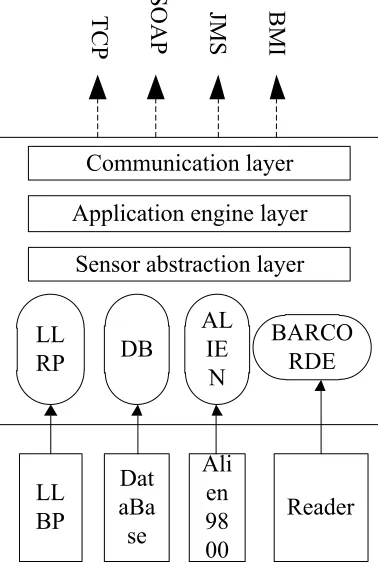
Sensor abstraction layer: server layer connects to Borcorde reader, RFID reader, terminal mobile devices and wireless sensors and other sensors, from which to collect logistics information for processing. The sensor abstraction layer allows the user to collect all the information needed for the application in a transparent manner. Appli-cation Engine Layers: The appliAppli-cation engine layer processes a large number of re-dundant events generated by the sensor abstraction layer and generates meaningful events needed by the logistics industry. The server uses a sophisticated event pro-cessing engine Esper that filters and identifies valuable events from a large number of event streams according to rules. Esper allows user to write query statements that are similar to database syntax. The overall architecture of the server layer is shown in Figure 2.
Communication layer
Application engine layer
Sensor abstraction layer
LL
RP
DB
AL
IE
N
BARCO
RDE
LL
BP
Dat
aBa
se
Ali
en
98
00
Reader
TCP
SOAP
JMS
BMI
Fig. 2. Overall structure of server layer
Communication layer: the communication layer will submit the processed data to the application system for integration to realize the information exchange. The design of various application interfaces in this layer achieves effective integration with the existing application system.
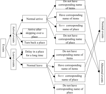
then the event information is stored in the database for the display, viewing and deal-ing with in user interface. In the distribution process, there are two main events: nor-mal events and abnornor-mal events. The nornor-mal events include that the designated items reach to the designated location and leave the designated location. Abnormal events indicate that the items are not transported according to the requirements, which in-cludes that items have missed a place, the goods are shipped back, the items don’t follow the prescribed route to transport, and there is no corresponding item name and the corresponding location name. The specific process is shown in Figure 3.
Events
Arrival events
Leave events
Normal arrive
Arrive after skipping over a
place Turn back a place
Delay in a place for a long time
Normal leave
Do not have corresponding name
of items
Have corresponding name of items
corresponding name of place
Do not have corresponding name
of place
Do not have corresponding name of
items
Have corresponding name of items
corresponding name of place
Do not have corresponding name of
place
Normal events
Abnormal events
Fig. 3. Application layer events analysis
3.3 System flow design
emergency situation such as line adjustment during the transportation of the goods is processed according to the change work order flow. Event work order can be generat-ed automatically or manually by the failure alarm event during work order processing. Event work order can lead to change work orders and problem work order. Users and customers can query the detail information of the transport process of goods through the system's service desk. Maintenance personnel of logistics operation can deal with the events produced in the transport of goods in accordance with the flow, and man-age the assets of logistics enterprises.
RFID module uses high-frequency RFID devices to collect data, and the goods in transit can be real-time queried. The user can get the information of the arrived items in time through text messages and Email, and can query the historical information. Geographic information system (GIS) is a comprehensive technical system that col-lects, stores, computes, retrieves, analyzes, displays and describes the geographical information in the whole or part of the Earth's surface space, supported by the com-puter network system. The geographic information system has the function of display-ing the geographical location information of the articles accurately. The system uses this function and the official Chinese map API interface provided by Google to devel-op to realize the visualization of the geographical information during the transporta-tion of goods, and can improve the accuracy of the display and maintain the articles line. The event generated by the system is processed through the flow process inter-face in accordance with pre-designed ITIL process, including the event work order process, the problem work order process and change work order process. The system automatically displays the work order to be processed on the corresponding label card. The system will automatically flow to the corresponding label card of the work order handler of the next task node for the work order that the current node task is processed. In the process of the whole work order, the process of the work order is in the closed-loop state, which greatly improves the efficiency of the work order pro-cessing.
4
Result analysis and discussion
reflecting the operation of the single node enterprise. Fourth, the method of real-time analysis and evaluation should be used as far as possible. Logistics real-time opera-tional information is more valuable than post-mortem analysis. Fifth, performance evaluation indicators can reflect the relationship between suppliers, manufacturers and customers. Sixth, performance evaluation indicators should be able to fully reflect the competitive advantage and competitive ability of logistics.
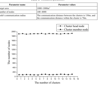
According to the principle of LSC algorithm, LSC algorithm is a distributed algo-rithm. It can cluster nodes in the asynchronous state of sensor nodes, and can realize the merging of different subnets. In addition, it has very strong extensibility. Node clustering algorithms that employ large-scale WSNs data collection also need to meet stability requirements. In order to evaluate the clustering stability of sensor nodes, simulation was carried out. The simulation parameters are shown in Table 1.
Figure 4 shows the network size of 2000 sensor nodes. When the communication distance in the cluster is r = 70m and the communication distance between the clusters is R = 150m, the number of cluster head nodes and cluster member nodes in 15 clus-ters is observed. It can be seen that the number of cluster head nodes and cluster member nodes always tends to be stable. The number of cluster head nodes and clus-ter member nodes in a clusclus-ter process is shown in Figure 4.
Table 1. Simulation parameters
Parameter name Parameter values
Target area 1000!1000m2
Number of nodes 100~4000
Node's communication radius The communication distance between the clusters is 150m, and the communication distance within the cluster is 70m.
0 1 2 3 4 5 6 7 8 9 10 11 12 13 14 15 16 0
200 400 600 800 1000 1200 1400 1600 1800 2000
The nu
mber of nodes
The number of clusters
Cluster head node Cluster member node
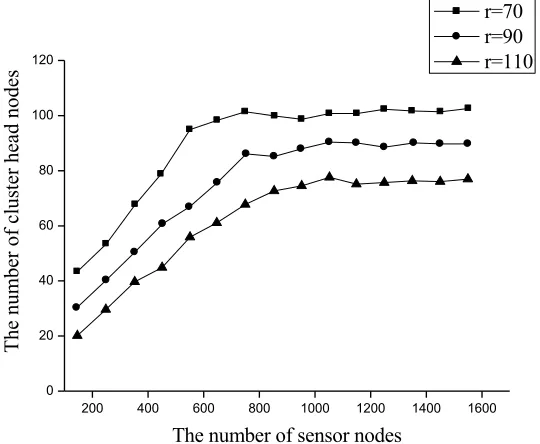
The influence of the number of sensor nodes on clustering is shown in Figure 5.
200 400 600 800 1000 1200 1400 1600 0
20 40 60 80 100 120
Th
e
num
ber of clus
ter head nod
es
The number of sensor nodes
r=70 r=90 r=110
Fig. 5. The influence of the number of sensor nodes on clustering
In the simulation calculation, the number of sensor nodes changes from 100 to 1500, and the interval increases by 100. When the number of nodes in the network increased to a certain scale, the number of cluster head nodes maintained at a stable level. The node density, which maintains the level of clustering stability, becomes the critical node density for stable clustering. It is related to the average number of nodes covered by the sensor node communication radius range.
Table 2. Inspection and verification of abnormal behavior experiment of cargo
Cargo behavior Accuracy /% Leakage rate /% false positive /% Misjudgment
results / sources
Tipping over 100 0 0 ——
Impact 100 0 0 ——
Shaking 100 0 3.2 moving
Moving 97.6 2.4 5.3 shaking, balance
As can be seen from Table 2, the LSC algorithm can accurately detect the tipping and collision of goods. Based on the maximum similarity of multi-feature recognition, it ensures that goods with obvious characteristics can be preferentially detected. By comparing the recorded results with the test results and observing the characteristics of the three-dimensional acceleration data of the cargo when the fault is detected, it is found that the fuzziness of the abnormal behavior of the cargo leads to a wrong detec-tion result. Among them, a slight and steady movement has not been detected and it is considered that the goods are in a state of equilibrium. The rapid acceleration and shutdown of the train results in a steady increase in the three-dimensional acceleration of the cargo, which is mistakenly detected as the movement of the cargo itself. The slight sloshing of the cargo (small amplitude) will also be detected as moving. From the above analysis, it can be seen that the LSC algorithm has higher accuracy for the detection of the abnormal behavior of goods. In the previous 80 tests, the error rate is less than 5%.
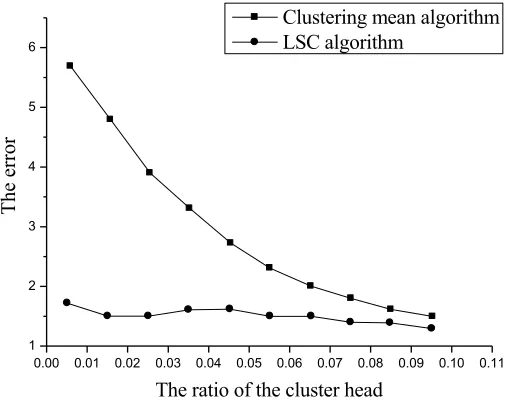
The algorithm can automatically adjust the number of fitting coefficients under the premise of ensuring the accuracy of data acquisition. Therefore, the error can always be controlled within a certain range. The relation between the error and the ratio of the cluster head is shown in Figure 6.
0.00 0.01 0.02 0.03 0.04 0.05 0.06 0.07 0.08 0.09 0.10 0.11 1
2 3 4 5 6
The erro
r
The ratio of the cluster head
Clustering mean algorithm LSC algorithm
5
Conclusions
Cargo tracking system is a multidisciplinary complex system engineering. It in-volves the Internet of things, wireless sensor technology, information technology, data fusion and other disciplines. The application of GPS technology is very important to the location of goods. However, during the transportation of the goods, the measure-ment information is inaccurate with the change of the surrounding buildings. The logistics tracking management system based on wireless sensor network technology is designed. The system realizes the tracking and monitoring of articles in the process of goods transportation, and adopts the ITIL idea to process the events produced in the process of transportation and realize the automatic management. The realization of the system makes the management of logistics and transportation more intelligent and humanized, and promotes the development of logistics industry information construc-tion. The emergence of wireless sensor network has brought new opportunities for the development of the logistics industry. With the popularity of RFID tags, information technology development of logistics industry will enter a new stage.
6
References
[1] Ding, K., Jiang, P., Sun, P., & Wang, C. (2016). RFID-enabled physical object tracking in process flow based on an enhanced graphical deduction modeling method. IEEE Transac-tions on Systems, Man, and Cybernetics: Systems.
[2] Fadiya, O., Georgakis, P., Chinyio, E., & Nwagboso, C. (2015). Decision-making frame-work for selecting ICT-based construction logistics systems. Journal of Engineering, De-sign and Technology, 13(2), 260-281.
[3] Huang, P., Xiao, L., Soltani, S., Mutka, M. W., & Xi, N. (2013). The evolution of MAC protocols in wireless sensor networks: A survey. IEEE communications surveys & tutori-als, 15(1), 101-120. https://doi.org/10.1109/SURV.2012.040412.00105
[4] Hinkka, V., Häkkinen, M., Holmström, J., & Främling, K. (2015). Supply chain typology for configuring cost-efficient tracking in fashion logistics. The International Journal of Lo-gistics Management, 26(1), 42-60. https://doi.org/10.1108/IJLM-03-2011-0016
[5] Mejjaouli, S., & Babiceanu, R. F. (2015). RFID-wireless sensor networks integration: De-cision models and optimization of logistics systems operations. Journal of Manufacturing Systems, 35, 234-245. https://doi.org/10.1016/j.jmsy.2015.02.005
[6] Oliveira, R. R., Cardoso, I. M., Barbosa, J. L., da Costa, C. A., & Prado, M. P. (2015). An intelligent model for logistics management based on geofencing algorithms and RFID technology. Expert Systems with Applications, 42(15), 6082-6097. https://doi.org/10.1016/ j.eswa.2015.04.001
[7] Pak, J. M., Ahn, C. K., Shmaliy, Y. S., & Lim, M. T. (2015). Improving reliability of par-ticle filter-based localization in wireless sensor networks via hybrid parpar-ticle/FIR filtering. IEEE Transactions on Industrial Informatics, 11(5), 1089-1098. https://doi.org/10.1109/ TII.2015.2462771
[9] Shamsuzzoha, A. H. M., Ehrs, M., Addo-Tenkorang, R., Nguyen, D., & Helo, P. T. (2013). Performance evaluation of tracking and tracing for logistics operations. Interna-tional Journal of Shipping and Transport Logistics, 5(1), 31-54. https://doi.org/10.1504/ IJSTL.2013.050587
[10] Xu, N., Zhang, Y., Zhang, D., Zhao, S., & Fu, W. (2017). Moving Target Tracking in Three-Dimensional Space with Wireless Sensor Network. Wireless Personal Communica-tions, 94(4), 3403-3413. https://doi.org/10.1007/s11277-016-3783-x
[11] Yan, Q. (2015). Research on Fresh Produce Food Cold Chain Logistics Tracking System Based on RFID. Adv. J. Food Sci. Technol, 7, 191-194. https://doi.org/10.19026/ajfst. 7.1292
[12] Yu, Q. (2016). Design of Logistics Tracking and Monitoring System Based on Internet of Things. Journal of Residuals Science & Technology, 13(5).
7
Author
Jijun Xing is with School of Business, Northwest University of Political Science and Law, Xi’an Shaanxi, 710063, China.