Middlesex University Research Repository
An open access repository of
Middlesex University research
http://eprints.mdx.ac.uk
Gilbert, Jérémie and Couillard, Valerie (2011) International law and land rights in Africa: the
shift from states’ territorial possessions to indigenous peoples’ ownership rights. In: Essays in
African Land Law. Home, Robert, ed. Pretoria University Press, pp. 47-68. ISBN
9781920538002
Published version (with publisher’s formatting)
This version is available at:
http://eprints.mdx.ac.uk/8350/
Copyright:
Middlesex University Research Repository makes the University’s research available electronically.
Copyright and moral rights to this work are retained by the author and/or other copyright owners
unless otherwise stated. The work is supplied on the understanding that any use for commercial gain
is strictly forbidden. A copy may be downloaded for personal, non-commercial, research or study
without prior permission and without charge.
Works, including theses and research projects, may not be reproduced in any format or medium, or
extensive quotations taken from them, or their content changed in any way, without first obtaining
permission in writing from the copyright holder(s). They may not be sold or exploited commercially in
any format or medium without the prior written permission of the copyright holder(s).
Full bibliographic details must be given when referring to, or quoting from full items including the
author’s name, the title of the work, publication details where relevant (place, publisher, date),
pag-ination, and for theses or dissertations the awarding institution, the degree type awarded, and the
date of the award.
If you believe that any material held in the repository infringes copyright law, please contact the
Repository Team at Middlesex University via the following email address:
eprints@mdx.ac.uk
The item will be removed from the repository while any claim is being investigated.
ESSAYS IN AFRICAN
LAND LAW
Robert Home (editor)
Published by:
Pretoria University Law Press (PULP)
The Pretoria University Law Press (PULP) is a publisher at the Faculty of Law, University of Pretoria, South Africa. PULP endeavours to publish and make available innovative, high-quality scholarly texts on law in Africa. PULP also publishes a series of collections of legal documents related to public law in Africa, as well as text books from African countries other than South Africa. This book was peer reviewed prior to publication.
For more information on PULP, see www.pulp.up.ac.za
Printed and bound by:
ABC Press Cape Town
To order, contact:
PULP
Faculty of Law University of Pretoria South Africa
0002
Tel: +27 12 420 4948 Fax: +27 12 362 5125 pulp@up.ac.za www.pulp.up.ac.za
Cover:
Yolanda Booyzen, Centre for Human Rights Cover photograph: Land Art, SurfGuard on Flickr
ISBN: 978-1-920538-00-2
© 2011
Essays in African land law forms part of the Rule of Law in Africa Project funded by the World Bank
iii
PREFACE v
CONTRIBUTORS vii
ACRONYMS AND ABBREVIATIONS ix
INTRODUCTION xi
ACKNOWLEDGMENTS xv
Perceptions of legal and geographic clarity: 1 Defining international land boundaries in Africa John W Donaldson
Towards a pro-poor land law in Sub-Saharan Africa 25
Robert Home
International law and land rights in Africa: 47 The shift from states’ territorial possessions to
indigenous’ people’s ownership rights Jérémie Gilbert and Valérie Couillard
Indigenous peoples and ancestral lands: 69 Implications of the Bakweri case in Cameroon’
Ambe J Njoh
Not just another ‘custom’: Islamic influences on 91 African land laws
Siraj Sait
The Humwe principle: A social-ordering grundnorm 113 for Zimbabwe and Africa?
Ben Chigara
Gender perspectives of property rights in 135 rural Kenya
Leah Onyango, Anne Omollo and Elizabeth Ayo
Legal challenges of land held in trust for orphans 155 and vulnerable children (OVCS) in Kenya
George Anang’a; Colleta Otieno and Awuor Oluoch
Compensation for compulsory acquisition of land 171 for mining activities in Nigeria: The search for a viable solution’
Oludayo Gabriel Amokaye
CONCLUSION 189
BIBLIOGRAPHY 191
1
2
3
iv
Table 1: Basic statistics by country x
Table 2: Humwe in a selection of African States 118 Table 3: Type of farming in relation to the European and 129
African zones (1962)
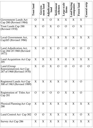
Table 4: Land Laws applied to different land management 142 systems in Kenya Land Statutes
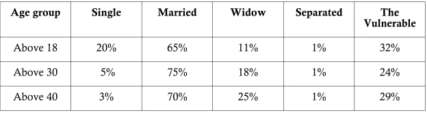
Table 5: Marital status of women in the Nyando river basin 149
LIST OF FIGURES
Figure 1: Land classification in Kenya 141
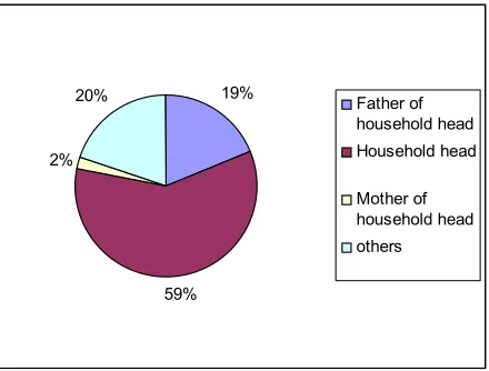
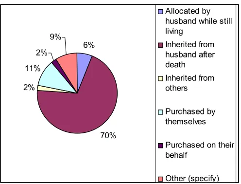
Figure 2: Land ownership in the Nyando river basin? 147 Figure 3: Ways through which women acquire land in the 148
v
Anglia Ruskin University has a growing number of students – both undergraduate and postgraduate – from the African continent, and UK students of African descent, and is proud to promote research that may aid African development. Professor Home has long experience of research on land issues in Africa. Since joining the University in 2002 he has managed a research project for DFID on land titling, which resulted in the book
Demystifying the Mystery of Capital (2004), and undertaken research and professional consultancies in several African countries. He was invited by the University of Pretoria to edit these two books on African land law, as part of a publishing project on the rule of law sponsored by the World Bank, and the University is pleased to be associated with the undertaking.
vii
Oludayo G AMOKAYE (LLB (Hons), LLM (Lagos), is a Doctoral Candidate at Obafemi Awolowo University and Senior Lecturer in Property and Environmental Law at the University of Lagos, Nigeria.
George ANANG’A has worked for over 20 years with community groups and international NGOs facilitating and writing on processes and platforms through which young people can acquire knowledge and skills in order to be able to advocate on issues that are important to them. He holds a Master of Arts Degree in Development Studies (University of East Anglia). He is currently Adviser to Development Education and Child Participation at Plan International UK.
Ben CHIGARA is Research Professor of International Laws at Brunel University, West London. He also serves as a jurist consultant in the areas of international trade and foreign direct investment law, constitutional reform and WTO. In addition, he is a lecturer/guest lecturer in many other universities.
Valérie COUILLARD is a human rights lawyer with the Forest Peoples Programme. She specialises in indigenous peoples’ rights as well as gender and land rights. She worked at the African Commission on Human and Peoples’ Rights (2005-2007) and practiced criminal law and human rights law in Canada (1999-2005). She holds a Master of Laws from the European Academy of Legal Theory (Brussels 2004). She sits as an expert member of the African Commission’s Working Group on Extractives Industries, Environment and Human Rights Violations in Africa.
John W DONALDSON MA (Durham), PhD (Durham) is senior research associate at the International Boundaries Research Unit, Department of Geography, Durham University.
Jérémie GILBERT is a Senior Lecturer in Middlesex University (United Kingdom). He has published various articles and book chapters on the rights of indigenous peoples, looking in particular at territorial rights for indigenous peoples. His latest monograph is Indigenous Peoples’ Land Rights under International Law (2007). He regularly collaborates with the Forest Peoples Programme and he is a member of Minority Rights Group advisory board on the legal programme.
viii
University of South Florida, USA. He has written 8 books and published more than 50 articles in peer-reviewed journals and books. He was one of the contributors to the UN ‘Global Report on Human Settlements 2009: Planning Sustainable Cities’.
Awuor OLUOCH holds aBA in Anthropology (University of Nairobi) and is currently pursuing an MA in Anthropology (Maseno University). Ms Oluoch is a research officer with the Kenya Medical Research Institute, attached to the ITM (Institute of Tropical Medicine-Belgium) Youth Interventions programme. She has conducted ethnographic research and participated in applied medical research work in rural western Kenya.
Anne OMOLLO is an Assistant Lecturer at Maseno University, Kenya. She holds an LLB and LLM Degree in Environmental & Natural Resources Law, University of Nairobi. She is also a partner at Anne Omollo & Kowinoh Advocates Co.
Leah ONYANGO holds a PhD in Physical and Urban Planning (Maseno University). She is Senior Lecturer at Maseno University and previously occupied several positions in the Ministry of Lands. She is currently involved in collaborative interdisciplinary research and development and extensively involved in community work specifically in the areas of environmental conservation and youth programmes.
Colleta OTIENO holds a Master of Arts (Maseno University) Degree. She is currently Deputy High School Principal in Kisumu, Kenya. She has researched on issues facing vulnerable children and worked with institutions providing support to children for over 20 years.
ix
AALS Affirmative Action Loan Scheme
ACHPR African Commission on Human and Peoples’ Rights AIDS Acquired Immune Deficiency Syndrome
AU African Union
AUBP African Union Border Programme BLCC Bakweri Land Claims Committee CBD Convention on Biological Diversity CBO Community-Based Organizations CDC Cameroon Development Cooperation
CEFRD Convention on the Elimination of all Forms of Racial Discrimination
CEMIRIDE Centre for Minority Rights Development
CLEP Commission for the Legal Empowerment of the Poor CRC Convention on the Rights of the Child
DFID Department for International Development DRC Democratic Republic of Congo
EAC East African Community
EDPRS Economic Development and Poverty Reduction Strategy EEBC Eritrea-Ethiopia Boundary Commission
FLTS Flexible Land Tenure System FPIC free prior informed consent GIS Geographic Information System
GLTN Global Campaign on Secure Tenure and the Global Land Tools Network
HIV Human Immunodeficiency Virus
IACHR Inter-American Commission on Human Rights ICC International Criminal Court
ICCPR International Covenant on Civil and Political Rights
ICISS International Commission on Intervention and State Sovereignty ICJ International Court of Justice
ICSID Settlement of Investment Disputes ILO International Labour Organisation LAC Legal Assistance Centre
LPA Liberal Peace Agenda LRO Land Right Office LRP Land Reform Programme LTO Land Titles Ordinance MCC Mogadishu City Charter MDG Millennium Development Goals
MINITERE Ministry of Land, Environment, Forestry, Water and Natural Resources
NGO Non-Governmental Organisations NHAG Namibia Housing Action Group NIE New Institutional Economics OAU Organisation of African Unity
OHSIP Oshakati Human Settlement Improvement Project OLL Organic Land Law
OTC Oshakati Town Council
OVCs Orphans and Vulnerable Children
SADC Southern African Development Community SDFN Shack Dweller Federation of Namibia
SERAC Center and the Center for Economic and Social Rights SFT Settlement Fund Trustee
SG Surveyor General SWA South West Africa
SWAPO South West Africa People's Organisation T&CPA Town and Country Planning Act
TCCF Technical Committee on Commercial Farmland TLA Tribal Land Act
UK United Kingdom
x
UNDP United Nations Development Programme UNDHR Universal Declaration of Human Rights
xi
The importance of land law for the rule of law in Africa can hardly be questioned. Population pressures and competition over access to land and resources generate much conflict, complicated by the historical legacy of colonial laws and land-grabbing, and by post-independence land law reforms. The international development agencies increasingly fund projects related to land law, policy and administration, with the Food and Agriculture Organisation (FAO) and Habitat each maintaining specialist land tenure units, and the AU and SADC formulating land policy frameworks.
This book on themes in African land law is one of a pair, the other presenting local case studies. It is not so easy to achieve an overview, nor to find specialist writers in the field. Land law has traditionally been regarded as a difficult subject to teach, and specialists are fewer in the law departments of African universities than one might expect. A quick scan of the index to fifty years of the Journal of African Law reveals less than one article a year with ‘land’ in the title, the most popular topics being the Nigerian Land Use Decree and tribal tenure in Botswana. Africa is less well served than other continents by specialist property law networks, and less represented at international academic conferences in the field. While Stellenbosch University in South Africa has a programme training academic land law specialists, that is an isolated initiative. The search for contributors to these books produced more non-Africans and those of the African diaspora than Africans working in their home country. Nor is African land law the exclusive preserve of lawyers, so other professions have represented, such as land surveyors, land economists and planners, as well as those working in NGOs. The list of authors thus includes a Cameroonian based in the USA, two Ghanaians and a Zimbabwean in UK academia, and within Africa a Tanzanian in Botswana and a Zambian in Namibia. With much research coming from outside the continent, non-African authors include three British, one French (geographer), one French-Canadian, one Texan (geographer), and one Dutch (land surveyor).
xii
Source: 2008-2010 official statistics
Chapter one (by John Donaldson) addresses the legal basis for national boundaries in Africa. The Cairo Declaration of the OAU in 1964 confirmed the existing colonially drawn boundaries, interpreted through the uti possidetis and intangibility principles. The limitations of treaty wording and survey methods meant that many boundaries were unclear, and took not much account of local environmental and social realities. Terms such as ‘thereabouts’ in boundary treaties had freed the colonising powers to interpret the territorial extent of African political entities as best suited their interests, and few boundaries were a tangible reality on the ground. The presence of mineral concession areas and white settler estates affected the methodology used to define boundaries, with the DRC/ Northern Rhodesia boundary an example of costly and precise delimitation because of the valuable mineral assets at stake. Donaldson argues for greater geographical clarity to avoid future disputes, as population density rises and pressure on land grows. Neighbouring states, however, may be understandably reluctant to embark upon boundary definition programmes that may provoke the very disputes they are intended to avoid – under what one might call the ‘let sleeping dogs lie’ principle.
Chapter two (by Jeremie Gilbert and Valerie Couillard) brings the viewpoints of a geographer and lawyer respectively, and their experience with the Forest Peoples Programme, to the topic of indigenous peoples’ land rights, which have emerged as a significant human rights issue with the UN Declaration on the Rights of Indigenous Peoples in 2007. The ACHPR has instituted a working party on the subject, with a somewhat different approach from the ‘first inhabitants’ approach followed in other parts of the world, and the historical context shows how international legal rules were designed by colonial powers, linking their self-defined civilising mission with the later doctrine of trusteeship. The authors explore the impact of the Endorois case, where the ACHPR in 2009 upheld local community rights against displacement by the government of Kenya for a nature reserve. At present few African countries recognise even the
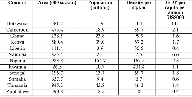
Country Area (000 sq.km.) Population
(million) Density per sq.km capita per GDP per annum US$000
Botswana 581.7 1.9 3.4 14.1
Cameroon 475.4 18.9 39.7 2.1
Ghana 238.5 23.8 99.9 1.6
Kenya 580.4 39.0 67.2 1.7
Liberia 111.4 3.9 35.5 0.4
Namibia 825.4 2.1 2.5 6.6
Nigeria 923.8 154.7 167.5 2.3
Rwanda 26.3 10.7 401.4 1.1
Senegal 196.7 13.7 69.7 1.8
Somalia 637.7 9.4 6.7 0.6
Tanzania 945.2 43.8 46.3 1.4
xiii
much potential for future disputes and human rights challenges.
Chapter three (by Ambe Njoh) presents a narrative of one such dispute, the long-running Bakweri land rights case in Cameroon, which was unique in having three different colonial masters – the Germans, British and French. The Bakweri were displaced from their ancestral lands for German plantation estates, which were taken over after the Second World War by the Cameroons Development Corporation, and successive governments have maintained their control. A committee to pursue the return of the Bakweri lands, encouraged by the Mabo case in Australia and others in the 1990s, took their claim successfully to the ACHPR in 2002. While less publicised than other indigenous minority land claims, the Bakweri case has implications beyond national frontiers. Postcolonial states have proved even less tolerant of customary entitlements that their colonial predecessors, and the Government of Cameroon has not complied with the judgment, showing a disregard for the rule of law in the form of the treaty which it had itself signed. One can, however, understand its reluctance to embark upon sorting out the unholy mess: one can turn fish into fish soup, but it is harder to turn the fish soup back into fish.
Chapter four (by Siraj Sait) explores how the ‘grand narrative’ of African land law generally overlooks Islamic land law, a developed land tenure framework which potentially applies to over a third of the continent. No country with significant Muslim populations is without the influence of Islamic land laws or principles, official or informal, however varied or mutated. As Islamic land law evolved in Africa, it often interlocked with customary, colonial and statutory systems, applying distinctive concepts that are still discernible today. He discusses country case studies of Kenya, Tanzania, Nigeria and Senegal.
Chapter five (by Ben Chigara) explores the possibility of a jurisprudence in Africa that actually draws upon indigenous African principles. Comparative law, and the theory of legal transplants, can be seen at work in the jurisprudence of the European Courts of Justice and Human Rights, where different legal traditions have to be interpreted together - so why not in African regional courts? He examines the Mike Campbell case, where the SADC court supported a narrow protection of private property rights (specifically the rights of white commercial farmers) against confiscation by the Zimbabwean state without compensation, but failed to acknowledge the longer historical perspective, in that the land had originally been confiscated without compensation from the indigenous population by white settler interests. Chigara argues that the principle of
humwe (a Shona word but with equivalents in many African languages) should be accorded recognition in the jurisprudence of the AU and regional courts of justice.
xiv
constitution does not guarantee fair and adequate compensation, and that the compensatory regimes are complex, inefficient and unsatisfactory.
Chapter seven (by Robert Home) explores the idea of a pro-poor land law from a historian’s perspective, locating African land law within the context of colonial intervention. A situation of legal pluralism was created through the ideology of the dual mandate, which distinguished between individual property rights for settler interests and urban areas, and customary tenure in the so-called African reserves in the rural areas with poorer soils. He examines who are the stake-holders in land law, the postcolonial rise of human rights law, and Hernando de Soto’s advocacy of property rights as a route to the legal empowerment of the poor.
xv
The financial support of the World Bank made possible two author workshops, creating the opportunity for many of them to meet in person for the first time, and build a group commitment to the enterprise. The first was held at Kisumu (Kenya) in May 2010, the second at Birkbeck College (London) in July 2010. I owe a special debt of thanks to two people: Serges Kamga, who steered the project and workshops, and Rory O’Hara, who was independent facilitator at both workshops. In no particular order, I also thank the following: Andre van der Walt, whose invitation to visit Stellenbosch University in 2008 indirectly led me to the project; Danie Brand and Christof Heyns of Pretoria University, who master-minded it; those who helped organise the Kisumu workshop (Bob Awuor of the African Community Development Foundation, Dan Kaseje and Rose Olayo of Great Lakes University Kisumu); Patrick McAuslan for offering a Birkbeck Collage venue for the second workshop; the independent chapter reviewers (Diane Dumashie and Ambreena Manji); the sub-editor, Oliver Fuo; and Tom Mortimer (my head of department at Anglia Ruskin University), Hilary Lim (University of East London), and Tatiana Beloborodova, who encouraged me throughout.
1
1
C
HAPTER
P
ERCEPTIONS
OF
LEGAL
AND
GEOGRAPHIC
CLARITY
:
D
EFINING
INTERNATIONAL
LAND
BOUNDARIES
IN
A
FRICA
John W Donaldson
1
Introduction
In 1905 King Victor Emmanuel III of Italy was approached by the British and Portuguese governments to arbitrate their disputed boundary between the British claimed territory of North-West Rhodesia (now western Zambia) and Portuguese West Africa (Angola). The boundary had been originally defined in an 1891 Anglo-Portuguese treaty as the western limit of Barotseland (Lozi) kingdom, since the Lozi Litunga (or king), Lewanika, had agreed to be under the British sphere of influence.1 In preparation for the case, British officials undertook research in areas west of the upper Zambezi river, interviewing local leaders and taking evidence concerning the influence of local chiefs who paid tribute to Litunga Lewanika, or recognised him as their paramount chief. After reviewing the evidence presented by both sides and assessing the respective territorial claims, King Emmanuel simply placed the boundary between the British and Portuguese territories north of the Kwando river along three lines of latitude and longitude, admitting:
Concerning delimitation of the territory over which King Lewanika reigned as paramount chief, all precise delimitation is impossible due to the lack of separating geographic features, the imperfect knowledge of the area, because of the notorious instability of tribes and their frequent intermingling (circumstances that were admitted also by the Marquis of Salisbury and the Marquis of Lansdowne), it is necessary, where natural lines are lacking, to have recourse to lines of geographic convention.2
The Barotseland arbitration encapsulates the abrupt clash of politico-territorial models that marked European imperialism in Africa.
1 For overview of the case, see Royal Geographical Society ‘The Barotse Boundary
Award’ (1905) 26 Geographical Journal 201 - 204.
2 UN ‘Award of 30 May 1905: The Barotseland Boundary Case (Great Britain, Portugal)’
Kopytoff explains that precolonial African political entities were usually separated by frontier zones of varying widths. This spatial arrangement was an essential characteristic of political organisation across much of precolonial Africa, as those individuals or groups that were cast out of core areas were then able to form new political organisations within the frontier zones.3 A fixed linear boundary separating equal political entities would have eliminated such frontier zones, and were not required on the less densely populated African landscape. In the case of large expansionist empires both in Africa and elsewhere, the limits of imperial territory would not have been viewed in a modern sense as the division of two legally equal states, but rather as the limit of the empire’s influence, beyond which was simply people and territory that had not yet been brought under imperial influence. The division of land at the village and familial scale was certainly nothing new in precolonial Africa where space within homesteads was strictly ordered. Ancient Egyptians even developed sophisticated techniques for land survey and registration. But while the division of political territory was not new to precolonial Africa, Mbembe suggests that this division was facilitated by ‘boundaries capable of infinite extension and abrupt contraction.’4
Despite popularised notions of European diplomats drawing lines across small scale maps of Africa, the intersection between nineteenth century imperialism and precolonial African political geography was more complex and nuanced particularly in relation to boundary-making. While imperial interests certainly took precedent over those of the precolonial African states, as the Barotseland arbitration reveals there were some attempts by colonial powers to determine boundaries based on the indigenous political states. Shaw challenges the idea that the European imperial powers considered the African continent to be terra nullius (land without sovereign) since the predominate method for acquiring title to territory was through acquisition agreements made with local rulers, indicating that European agents must have recognised some degree of legal sovereignty.5
In the cases of African territory acquired by European imperial powers through treaties with indigenous political leaders (rather than through conquest), it is overly simplistic to assert that those African leaders had no concept of what their agreements with the imperial powers implied. Many saw it as an opportunity to increase their own power over neighbouring groups, securing political allegiance to a powerful ally or beneficial commercial arrangement.6 However, most pre-imperial African leaders would have had little idea what the treaties they agreed with European
3 I Kopytoff The African frontier (1987) 10.
4 A Mbembe ‘At the edge of the world (2000) 12 Public Culture 263 - 264.
5 MN Shaw Title to territory in Africa (1986) 36 - 38.
6 GN Uzoigwe ‘European partition and conquest in Africa’ in AA Boahen (ed) General
representatives might mean in the longer term. This is not to mention the serious legal questions that would be raised concerning the validity of those agreements, the legal capacity of European officials presenting the agreements, any coercive activity, ambivalent wording of documents and inherent prejudice towards written documentation, all of which have been exposed by McEwen.7
Aside from their dubious legality, the so-called treaties agreed with local African political leaders were (often deliberately) vague on the geographic extent of those political entities.8 This gave the European colonial powers carte blanche (quite literally) to interpret the geographic extent of territory ceded by local political leaders as they saw fit. In some cases, the extent of territory controlled by local leaders mentioned in these treaties was left vague or was simply dictated by the European agent concluding the agreement. For example, the extent of Chief Kawinga’s territory in part of what is now Malawi as defined in a 15 June 1891 agreement, was determined by John Buchanan of the British South Africa Company, acting as vice consul of Nyassaland.9 Take this remarkable statement opening the 3 December 1886 agreement between Great Britain and Zanzibar that defined the limits of the Sultan’s dominions:
I am instructed by Her Majesty’s Government to communicate to your Highness the particulars of an Agreement which has been entered into between the Governments of Great Britain and Germany for the purposes of delimitating the extent of the territory which they are prepared to recognise as under your Highness’ sovereignty.10
Another example, from an area of north-eastern Zambia, is the 30 September 1890 definition of Kasembe’s territory, in an agreement with a representative of the British South Africa Company:
Boundaries thus defined: ‘Bounded on the west by Lake Moero and the Luapula River; on the south by latitude 10° 30’ (or thereabouts); on the north by the Kalongwizi River and by latitude 9° 20’ (or thereabouts); on the east by east longitude 30° (or thereabouts).’11
Left deliberately vague, with terms such as ‘thereabouts’ or using geographical terms unlikely to have been familiar to African leaders, the European imperial powers gave themselves the privilege of interpreting the territorial extent of African political entities as best suited their interests.
7 AC McEwen International boundaries of East Africa (1971) 12 - 16. See also A Allott,
‘Boundaries and the law in Africa’ in CG Widstrand (ed) African Boundary Problems
(1969).
8 McEwen (n 7 above) 16.
9 E Hertslet The Map of Africa by Treaty (1909) 189.
10 Hertslet (n 9 above) 754.
Just as the definition of land provides the constitutive aspect of a title deed, so an international boundary provides the definition of territory as the foundation of state sovereignty, from which subsequent land rights flow.12 Colonial administrations tended to hold that precolonial African conceptions of communal land rights ‘implied a lack of advancement; an “early” stage’ and were therefore more easily expropriated,13 just as the division of territorial polities by zonal frontiers was considered at the time of the initial territorial division of Africa to indicate more primitive political development.14 Chanock reviews the recommendations of the British colonial administrator Lord Hailey who in 1938 encouraged demarcation of communal land and ‘knew that some form of survey was the essential pre-condition to the definition of any form of title.’15 Chanock notes that ‘the administrative resources of the colonial regimes in Africa were generally not up to the kind of survey required to give indefeasible title.’16
While purporting to bring stability to the political landscape of Africa through the imposition of fixed boundaries,17 the legacy of boundary definition across Africa is filled with geographic ambiguities, since colonial administrations never provided any consistency in the definition of inter or intra-colonial boundaries. Instead of inheriting clearly defined territorial spaces at independence, post-independent African governments were left with international boundaries subject to wide range of definitions. African governments have been slow to address the clarity of boundary definition, sometimes leaving the difficult task of interpreting the ambiguous definitions left by colonial administrations to the International Court of Justice. The problems of geographic interpretation are, however, just as relevant for land rights below the state level, where boundary disputes are just as prevalent, and often just as violent, as those between neighbouring states. According to Unruth:
12 Shaw indicates that ‘sovereignty itself, with its retinue of legal rights and duties, is
founded upon the fact of territory. Without territory a legal person cannot be a state.’
MN Shaw International law, fourth edition (1997) 331.
13 M Chanock ‘A peculiar sharpness’ (1991) 32 The Journal of African History 70.
14 See especially: AP Brigham ‘Principles in the determination of boundaries’ (1919) 7
Geographical Review 201 - 219. The historical distillation from frontier zones to linear boundaries has also been reviewed by numerous international lawyers and political geographers in a variety of contexts outside Africa. See especially JW Donaldson
Marking territory (PhD thesis, Durham University, 2010) 47 - 57; SB Jones ‘Boundary
concepts in the setting of place and time’ (1959) 49 Annals of the Association of American
Geographers 241 - 255; LKD Kristof ‘The nature of frontiers and boundaries’ (1959) 49
Annals of the Association of American Geographers 269 - 282; JG Ruggie ‘Territoriality and
beyond’ (1993) 47 International Organization 139 - 174.
15 Chanock (n 13 above) 74.
16 Chanock (n 13 above) 74.
17 Although focusing on the Hausa in northern Nigeria and Niger as distinct cultural and
political entities, Miles did find, contrary to the general assertion that the division of West Africa by colonial boundaries was an ‘unmitigated evil,’ that ‘Among the people most directly affected – the borderline Hausa – there is rather a continued appreciation that the partition heralded an end to the incessant warfare waged between surrounding
Effective boundary demarcation is a large and confusing problem, not only for countries (and subunits), but also for concessions, individual deed holders, tribal lands, and state and public lands. In a number of cases how much land exists in the various countries and concessions is unknown. In others, mistaken numbers are used to calculate such areas ... The overall situation is that sub-national boundaries exist in severe disarray.18
The primary role of any land boundary is to prevent conflict, but this depends upon the respect given to it by the neighbouring parties (whoever they might be). In order to be respected, a boundary requires both recognised legal validity and clearly identifiable geographic position. Clear definition of international boundaries, just like the clear definition of a land plot, does not lead inevitably to the physical isolation of that geographic area (through fencing, barriers or walls), or the termination of existing cross-border administrative regimes.19 Nor does it presume a homogeneity of rights within each neighbouring geographic area, as rights may be shared or managed cooperatively.20 These are subsequent political decisions concerned with how the boundary operates after it has been established.
This chapter will suggest that, given the constitutive role played by boundaries in land and territorial rights, a lack of geographic clarity in their definition actually undermines the legal validity of that title, by leaving areas open to overlapping claims and creating the opportunity for dispute. The chapter will first explore that relationship between the legal continuity of inherited title to territory and its geographic definition in relation to international boundaries in Africa, by critically assessing the geographic assumptions imbedded in the uti possidetis doctrine and in the often misinterpreted ‘intangibility’ principle most famously expressed in the 1964 Cairo Declaration of the OAU. It will then examine some of the inconsistencies in colonial boundary-making practices that continue to cause disputes at a variety of social, political and geographic levels across Africa’s international boundaries, disputes that frequently expose other underlying tensions between neighbouring states. The inconsistent boundary-making methodology used by colonial administrations was often linked to issues of land use and economic value. In this regard, geographic clarity of title through well-defined boundaries has often been used as a tool by powerful actors for securing more durable land rights that
18 JD Unruth ‘Land rights in post-war Liberia’ (2009) 26 Land Use Policy 428.
19 Ratner recalls that the Burkina Faso-Mali judgment called for cross-border authority to
be discounted if in conflict with the ‘clear line of title but suggests that the ICJ ‘does not
make clear how to handle such de jure cross-border authority.’ SR Ratner ‘Drawing a
better line’ (1996) 90 American Journal of International Law 607.
20 Witness the sharing of managerial responsibilities in the transboundary parks across
are less likely to be disputed. While land survey and boundary demarcation may be considered ‘technical’ exercises,21 the lesson to be drawn from international boundary practice is that geographic clarity should be seen as functionally equivalent to legal validity in order for boundaries to fulfil their primary role in the prevention of disputes.
2
Uti possidetis
and the intangibility principle
Since 1957, the beginning of formal de-colonisation in Africa, the ICJ has adjudged eight international land boundary disputes (excluding maritime boundary and island sovereignty disputes), of which no less than five have been located in Africa.22 These are as follows: Burkina Faso/Mali 1983 -1986,23 Libya/Chad 1990 - 1994,24 Cameroon v Nigeria 1994 - 2002,25 Botswana/Namibia 1996 - 199926 and Benin/Niger 2002 - 2005.27 Three international arbitrations since 1957 dealing directly with questions of land boundary definition have involved at least one African state: Egypt-Israel 1988,28 Eritrea-Ethiopia 2002 - 200829 and the Abyei arbitration (Sudan) 2009.30
Since the 1986 judgment in the Burkina Faso/Mali case, the resolution of international boundary disputes in Africa has been dominated by one overriding international legal principle, originally known by the Latin maxim, uti possidetis ita possidetis.31 The short-hand term ‘uti possidetis’ is now used in international law as reference to a very specific interpretation of that original Latin maxim. Lalonde explains that two differing interpretations were debated by early jurists: uti possidetis de facto and uti possidetis juris.32 The former refers to recognition of the de facto possession
21 JW Donaldson & A Williams ‘Delimitation and demarcation’ (2008) 13 Geopolitics 687
- 690.
22 A ninth case (also from Africa) concerning a land boundary dispute between Burkina
Faso and Niger was submitted to the ICJ in July 2010.
23 Frontier Dispute (Burkina Faso/Mali) ICJ (22 December 1986) (1986) ICJ Reports 1986. 24 Territorial Dispute (Libyan Arab Jamahiriya/Chad) ICJ (4 February 1994) (1994) ICJ
Reports 1994.
25 Land and Maritime Boundary Between (Cameroon v Nigeria with Equatorial Guinea
intervening) ICJ (10 October 2002) (2002) ICJ Reports 2002.
26 Dispute over Kasikili/Sedudu Island (Botswana/Namibia) ICJ (13 December 1999) (1999)
ICJ Reports 1999.
27 Frontier Dispute (Benin/Niger) ICJ (12 July 2005) (2005) ICJ Reports 2005.
28 Award in the Dispute Concerning Certain Boundary Pillars between the Arab Republic of Egypt
and the State of Israel Arbitral Tribunal (29 September 1988) (1988).
29 Decision on the delimitation of the border between Eritrea and Ethiopia Eritrea-Ethiopia
Boundary Commission (EEBC) (13 April 2002) (2002).
30 Final Award of Abyei Arbitration (Government of Sudan/Sudan People’s Liberation
Movement-Army) Arbitral Tribunal (22 July 2009) (2009).
31 The term is loosely translated ‘as you possess so you shall possess’. Indicating that the
merits of boundary cases are often over-shadowed by the confirmation or non-confirmation of international legal norms, Ratner suggests that ‘the ICJ’s
pronouncement on the contours of uti possidetis in the Burkina Faso/Mali case are now
the primary source for that rule ...’. SR Ratner ‘Land feuds and their solutions’ (2006) 100 American Journal of International Law 814.
of territory and latter to the possession of territory through recognised legal title (juris). International law has developed to give deference to the later over the former so that the term uti possidetis now refers to uti possidetis juris. In its judgment in the Burkina Faso-Mali Frontier case, the ICJ asserted that uti possidetis was a general principle of international law, characterised by the ‘pre-eminence accorded to legal title over effective possession as a basis of sovereignty.’33 Uti possidetis was described by the Chamber as follows:
It is a general principle, which is logically connected with the phenomenon of the obtaining of independence, wherever it occurs. Its obvious purpose is to prevent the independence and stability of new States being endangered by fratricidal struggles provoked by the challenging of frontiers following the withdrawal of the administering power.34
The essence of the principle lies in its primary aim of securing respect for the territorial boundaries at the moment when independence is achieved. Such territorial boundaries might be no more than delimitation between different administrative divisions or colonies of the same sovereign.35
The Chamber admitted that uti possidetis could be in tension with another general principle of international law, that of self determination.36 It was adamant that uti possidetis provided the most stable territorial platform for the peaceful succession of sovereignty to post-independence governments in Africa.
... the maintenance of the territorial status quo in Africa is often seen as the wisest course, to preserve what has been achieved by peoples who have struggled for their independence, and to avoid a disruption which would deprive the continent of the gains achieved by so much sacrifice.37
The subject of uti possidetis as a legal principle in post-independence Africa has generated much discussion among international legal scholars, in debates about the macro-geography of post-independence Africa, role of pre-colonial polities/identities and legitimacy of colonial territorial title.38 This chapter does not repeat the analyses, nor does it purport to address the tension between uti possidetis and self determination. Instead, it will explore how the nature of uti possidetis is imbued with geographic assumptions about the definition of territorial title relating to localised/micro-territorial boundary definition.
33 Burkina Faso/Mali (n 23 above) para 23. 34 Burkina Faso/Mali (n 23 above) para 20. 35 Burkina Faso/Mali (n 23 above) para 23. 36 See Burkina Faso/Mali (n 23 above) para 25. 37 Burkina Faso/Mali (n 23 above) para 26.
38 Wa Mutua, M ‘Why redraw the map of Africa’ (1994-95) 16 Michigan Journal of
International Law 1113 - 1176; B Davidson Black Man’s Burden (1992); I Griffiths The African inheritance (1995); A Asiwaju (ed) Partitioned Africans 1884-1984 (1985); J Klabber
& R Lefeber ‘Africa possidetis’ in C Brolmann et al (eds) Peoples and minorities in
With its emphasis on continuity and stability, uti possidetis observes the legal consistency of inherited boundary agreements, but in doing so it presumes that all inter and intra-colonial boundaries had reached a single common degree of geographic clarity at independence. The reality of that territorial inheritance was however much more haphazard. Some inter and intra-colonial boundaries in Africa were clearly marked on the ground and accurately documented, while others were left more geographically ambiguous, unmarked on the ground and poorly described. Independent African governments have been slow to address such ambiguities. Over forty years after the 1964 Cairo Assembly, where the post-independence African leaders pledged to respect their inherited colonial boundary agreements, the African Union constituted a Border Programme (AUBP) with the express aim of encouraging African governments to clearly delimit and demarcate their boundaries by 2012.39 In its constitutive document, the AUBP estimated that (subject to a thorough inventory) less than a quarter of African boundaries ‘have been delimited and demarcated.’40 Various issues have been cited by African governments for the lack of attention to international boundary definition, most commonly lack of financial resources, and lack of attention from what the neighbouring state. These are reasonable problems, but not insurmountable, given adequate political will on both sides to reach an amicable and mutually beneficial boundary definition that is free of ambiguities.
At the second assembly of the OAU in Cairo in July 1964, all but two heads of state of independent African states agreed what has been subsequently referred to as the Cairo Declaration.41 Perhaps its most famous and controversial clause was Resolution 16/1, cited widely in the Burkina Faso-Mali judgment and referred to as the definitive ‘border arrangement for Africa.’42 It is often used to describe the functional impact of uti possidetis, even though the term itself is notably absent from the text.
AHG/Res. 16(1)
Considering that border problems constitute a grave and permanent factor of dissention;
Conscious of the existence of extra-African manoeuvres aimed at dividing African States;
39 Declaration on the African Union Border Programme and its Implementation Modalities as
Adopted by the Conference of African Ministers in Charge of Border Issues held in Addis Ababa, 7 June 2007 African Union (AU) (2007).
40 As above art 2(a).
41 The Cairo Assembly of Heads of State was boycotted by King Hassan of Morocco as a
result of a boundary dispute with Algeria, and by the leader of Somalia as a result of Somalia’s continuing claims to ethnic Somali areas in Ethiopia and Kenya. See especially S Touval ‘The Organization of African Unity and African borders’ (1967) 21
International Organization 102 - 127.
Considering further that the borders of African States, on the day of their independence, constitute a tangible reality;
Recalling the establishment in the course of the Second Ordinary Session of the Council of the Committee of Eleven charged with studying further measures for strengthening African Unity;
Recognising the imperious necessity of settling, by peaceful means and within a strictly African framework, all disputes between African States;
Recalling further that all member states have pledged, under article IV of the Charter of African Unity, to respect scrupulously all principles laid down in paragraph 3 of article III of the Charter of the Organization of African Unity: (1) SOLEMNLY REAFFIRMS the strict respect by all member states of the Organization for the principles laid down in paragraph 3 of article III of the Charter of the Organization of African Unity;
(2) SOLEMNLY DECLARES that all member states pledge themselves to respect the borders existing on their achievement of national independence.43
The second operative paragraph, whereby the members of the OAU agree to respect the borders inherited at independence, was used by the ICJ to describe the acceptance of uti possidetis as a legal principle by post-independence African states. Often overlooked is the very specific wording used in the third sentence of the preamble which indicates that ‘the borders of African States, on the day of their independence, constitute a tangible reality.’ A powerfully explicit phrase, but did all of the boundaries between the newly independent African states really ‘constitute a tangible reality’ at their respective dates of independence?
Lalonde’s major study of uti possidetis in relation to boundary determination, makes an interesting comparison between the de-colonisation processes in Latin American and Africa. She suggests that, at de-colonisation in Latin America, the first question was which former colonial administrative units would become independent states, followed by ‘how would those boundaries be determined?’44 In other words: ‘For Latin American republics, it was not simply a question of maintaining the territorial status quo but of actually creating the territorial status quo.’45 The ambiguity of both political and territorial distinctions at the moment of de-colonisation led to many years of conflict between the emerging Latin American states during the early to mid 19th century.
In the African context, Lalonde suggests the process was different since the political distinction between colonial administrations was clearer. ‘Devolution occurred within the territorial limits as defined by the metropolitan powers, which were at liberty to adjust boundaries and
43 Resolutions adopted by the first ordinary session of the assembly of heads of state and government
held in Cairo 17-21 July 1964 (Cairo Declaration) Organization of African Unity (1964) AHG/Res 16(1).
44 Lalonde (n 44 above) 121 - 22.
transfer territory right up to the date of independence.’46 Lalonde believes that the colonial boundaries across Africa were ‘defined with much greater precision than the Spanish administrative lines.’47 She concludes that the concept of uti possidetis for Latin American states provided entitlement to boundaries of the former Spanish administrative divisions ‘at law’ while ‘the newly independent African states, for their part, merely agreed to accept those boundaries, in fact, that existed at the date of independence.’48 This may explain why the Cairo declaration specifically avoids the term uti possidetis. Lalonde hints at the variety of boundary definitions existing across Africa at the moment of de-colonisation, by suggesting that:
Those boundaries that had been established and clearly demarcated were, following independence, protected according to general principles of international law. Those boundaries that had been unsettled during the colonial period remained unsettled.49
While most boundaries inherited by African states at independence were defined arguably with greater geographic precision than the vague limits of Spanish colonial administration in Latin America before 1810, it should not be concluded that all African boundaries constituted a ‘tangible reality’ at independence. The only distinction Lalonde makes between settled and unsettled boundaries does not begin to indicate the many ways that boundaries were defined in colonial boundary agreements and inherited at independence. The term ‘tangible reality’ suggests that a boundary can be recognised on the physical landscape. Implying that one knows precisely when he/she passing across the static, fixed and linear limit of one state jurisdiction into another. This could take the form of a river, or a series of boundary pillars, but the importance is that the extent of legal title is clearly known to those within the border landscape.
A boundary may be depicted on a map but that does not that make it a ‘tangible reality.’ A boundary may be defined in a legally binding text with greater or lesser precision, but that also does not make it a ‘tangible reality.’ Did the African leaders at the 1964 Cairo assembly believe or assume that their state boundaries constituted tangible realities? Was this phrase used consciously to deflect attention away from inadequate boundary definition that may have led to more disputes? Whatever the case, the statement in the Cairo declaration belies consistent definition of boundaries across the continent, and the reality was a much more haphazard territorial inheritance.
46 n 44 above, 122.
47 n 44 above, 123.
48 n 44 above, 122.
3 Inconsistent
definition
Lalonde, while distinguishing between ‘settled’ and ‘unsettled’ boundaries, admits that some African boundary sections were not ‘settled’ at the time of independence, but does not make clear if ‘settled’ refers to a verbal, cartographical or tangible boundary definition. Taking the phrase ‘tangible reality’ as a measure, few boundary sections across Africa would have been a reality on the border landscapes at the time of independence. Some boundary sections were accurately surveyed and/or relatively clear on the ground. The section of the DRC-Zambia boundary along the Congo-Zambezi watershed had been demarcated with painstaking precision between 1927 and 1933, and an irregular maintenance regime ensured that much of this section was clearly visible at Congolese and Zambia independence in 1960 and 1964 respectively.50 The Kenya-Ethiopia boundary was also demarcated clearly and documented with geographic precision in the 1950s and 1960s, although the agreement itself was not ratified until 1970 after long negotiations over transboundary grazing rights.51
Those international boundary sections that follow large rivers (such as the Zambezi, Ruvumu, Congo, Ubangi) also would have been readily apparent on the border landscape at independence.52 However, much of Africa’s international boundary sections are defined along small rivers and streams, many of which may not contain water for parts of the year and may move dramatically from year to year.53 For some imperial governments, rivers and streams made a sound, cost-effective substitute for expensive boundary pillars.54 For example, the 1912-15 Anglo-Portuguese boundary commission revised the northern section of the Angola-Northern Rhodesia boundary from the 24° E meridian to follow a complex series of local streams as a substitute for more expensive overland
50 Donaldson (n 14 above) 184 - 187.
51 9 June 1970 Ethiopia-Kenya border treaty in I Brownlie African Boundaries (1979) 791
-822.
52 Along several of these river sections, the colonial agreements did not specify where the
boundary line ran within the rivers themselves, as was the case along the lengthy sections of DRC-Congo boundary section along the Congo and Ubangi rivers on either side of Stanley Pool. However, as an unmistakable landmark such large rivers form a visible division between neighbouring jurisdictions on the ground.
53 See the International River Boundaries Database, International Boundaries Research
Unit, Durham University. http://www.dur.ac.uk/ibru/resources/irbd (accessed 30 July 2010).
54 JW Donaldson ‘Pillars and perspective: demarcation of the Belgian Congo-Northern
Rhodesia boundary’ (2008) 34 Journal of Historical Geography 485. When suggesting to
the German government in 1908 that portions of the Nigeria-Kamerun boundary should be adjusted to follow natural features, Sir WE Goschen argued: ‘The selection of natural features such as streams and rivers has many advantages, not the least of which is that far fewer boundary pillars are required.’ National Archives (Kew) file FO
demarcation.55 Although depicted as distinct blue lines on boundary mapping, many of these small streams may not be as distinct on the ground, being subject to seasonal rainfall.56
The devolved nature of British colonial administration meant that some of the intra-colonial boundaries were described with a degree of clarity in administrative records and maps, such as the 1926 Order in Council defining much of the Kenya-Uganda boundary57 or the 1930 provisional administrative line between Sudan and Uganda. However, in many cases the British intra-colonial boundaries were never, or perhaps only crudely, demarcated on the ground. Due to the changing nature of French colonial administrative ‘cercles’ most intra-French colonial boundaries had no clear description either in administrative texts or maps, and most were never demarcated on the ground. There were some initiatives by the colonial governments to finalise agreements over disputed boundary sections as de-colonisation gained momentum in the late 1950s. British and Belgian officials hastened negotiations over the long disputed section of the Belgian Congo-Northern Rhodesia boundary between Lakes Mweru and Tanganyika in an ultimately unsuccessful attempt to resolve the dispute before Congolese independence in 1960.58
For the most part, however, huge lengths of colonial boundaries across Africa were not even close to being ‘tangible realities’ on the physical landscapes at the respective dates of independence. Many were simply roughly surveyed, with the understanding that they would be marked on the ground with greater precision at a later date. This was the case along the watershed between the Congo and Nile rivers that forms much of Sudan’s boundaries with neighbouring Central Africa Republic and the DRC, partially surveyed in the early 1920s but never marked on the ground.59 The quality and accuracy of the mapping used to define boundaries in the early colonial period was sometimes poor, even though it may have been attached to a treaty as the legally binding definition.60 In addition, the coverage of large scale, accurate topographic mapping undertaken under late colonial administrations varied widely across Africa at independence.
55 See Instructions for the boundary commission National Archives of Zambia file NRA
1/1/7 6004 Memorandum from War Office to Secretary of State (Colonial Office) 14 November
1912 (1912). See also Office of the Geographer, United States Department of State ‘No
119 Angola-Zambia Boundary’ (1972) International Boundary Study 4.
56 JW Donaldson ‘Where rivers and boundaries meet’ (2009) 11 Water Policy 629 - 644.
57 Brownlie (n 51 above) 943 - 945.
58 See especially the correspondence related to negotiations over the Pedicle Road treaty
in the NA (Kew) files CO 1015/1396, CO 1015/1397, CO 1015/2180 and CO 1015/ 2181.
59 Brownlie (n 51 above) 628 - 636.
60 The 1900 Abyssinian-Italian agreement that defined much of the Eritrea-Ethiopia
Some boundary sections may have been demarcated in the late 19th and early 20th centuries, but the fairly crude and impermanent marks were unlikely to still be visible at the time of independence. The lengthy overland section of the Ethiopia Sudan boundary between what is now the tripoint with Eritrea and the Baro River was marked on the ground in 1903 with just 36 pillars, many of which disappeared soon after they were erected.61 From blazed trees and iron telegraph poles to concrete pyramids and cleared tracks, there was no consistency in the methodology of demarcation used by colonial officials The OAU heads of state could hardly have addressed every possible boundary situation in the Cairo declaration, but used a phrase as explicit as ‘tangible reality’, when the reality was much less clear.
One explanation for the wide disparity in boundary definition is the influence of economic resources on colonial boundary policy. Research into the history of colonial boundary practices in southern Africa reveals that the presence of mineral concession areas and white-owned farming had a dramatic impact on the methodology used to define inter and intra-colonial boundaries.62 The most egregious example was the boundary between Belgian Congo and Northern Rhodesia, first delimited by an Anglo-Congolese agreement in 1894. The lengthy section of the boundary along the Congo-Zambezi watershed was first marked on the ground by an Anglo-Belgian boundary commission (1911 - 14), defining 800 km of the boundary with just 46 pillars, an average of 15 miles between boundary marks.63 Located in a plateau region, much of the watershed itself is indistinct on the ground and the rudimentary demarcation left large sections of the boundary unclear between the boundary pillars. When huge copper deposits in the Katanga/Copperbelt regions became commercially exploited in the 1920s, mining companies demanded that the boundary along the watershed be accurately marked so that there would be a clear division between Belgian and Rhodesian concession areas.64 A second Anglo-Belgian boundary commission (1927 - 1933) established auxiliary boundary pillars along the watershed section every 500 metres and dug a half metre deep ditch that quite literally etched the boundary on the ground, in the most expensive colonial boundary programme in Africa, leaving no ambiguities as to the course of the boundary in these areas of valuable mining concessions.
There are other examples such as the current Mozambique – Zimbabwe boundary (formerly Portuguese East Africa-Rhodesia), where
61 TH Al-Nur ‘The Sudan-Ethiopia boundary’ unpublished PhD thesis, University of
Durham, 1971 116. As of late 2009, this boundary is currently being reviewed and possibly demarcated jointly by Ethiopia and Sudan.
62 This is only hinted in JRV Prescott & G Triggs International Frontiers and Boundaries
(2008), but is explored in more depth in Donaldson (n 54 above).
63 NA of (Zambia) file RC 609 Memorandum by Fairweather 30 September 1924 (1924)2.
mining and white farming interests prompted clear definition.65 However, for the majority of border areas where there was nothing of economic interest to the colonial governments, boundary definition was left in varying degrees of ambiguity. The influence of economic resources on boundary definition reflects many postcolonial critiques of colonial policy that was focused exclusively on the resources of the land rather than administration of populations. According to Mbembe: ‘The colonial space had its space, its shape, its borders. It had its geological make up and its climates. It had its resources, its soils, its minerals, its animal and plant species, its empty lands. In short, it had its qualities.’66 Early definitions left over from the initial round of territorial delimitation during the so called ‘scramble’ of the late 19th century were retained, including imprecise textual descriptions and inaccurate – often wildly inaccurate – mapping. Although under uti possidetis the inter and intra-colonial agreements and administrative records were considered legally valid in defining the territory of independent African states, in no way could many of these early boundary definitions be considered to be ‘tangible realities’ in the landscape. The approach by the colonial administrations, linking boundary definition with land use, left inconsistencies imbedded in the boundary treaties which in turn became the ‘root of title’ for post-independence African states.67 The vague language, and in many cases poor cartographic depiction of many boundaries, left open to interpretation on the human and physical landscape ambiguities that continue to cause conflict and confusion across the continent.
4
Consequences of poor definition
On 6 May 1998 in the village of Badme located in the border region between Eritrea and Ethiopia, an argument between local troops from both sides led to shots being fired. Although the exact sequence of events on that day is disputed, the lack of an agreed and defined limit to the neighbouring jurisdictions created confusion and overlapping claims, eventually precipitating a full scale conflict lasting two years and claiming some 70,000 lives.68 There have been numerous conflicts in post-independence Africa related to secessionist movements and large-scale geopolitical tensions between neighbouring states, often involving large territorial claims, such as the attempted secessions of Katanga in DRC and Biafra in Nigeria during the mid-1960s, or Somalia’s long-standing claims to areas of eastern Ethiopia. These conflicts have concerned boundary definition on a macro-geographical level. Many other minor disputes continue to
65 P Warhurst ‘A troubled frontier 1898 - 1906’ (1978) 77 African Affairs 214. See also
Donaldson (n 14 above) 175 - 177.
66 A Mbembe On the Postcolony (2001) 32.
67 Prescott & Triggs (n 62 above) 170.
68 M Plaut ‘The conflict and its aftermath’ in D Jacquin-Berdal & M Plaut (eds) Unfinished
arise as a direct result of imprecisely defined boundaries. In most of these situations, the neighbouring states agree that a boundary does exist between them and may even agree on the actual instrument that defines the boundary, but dispute the position of the boundary on the ground. The Eritrea-Ethiopia example indicates that such seemingly minor disputes can quickly escalate into large-scale conflict.
Minor disputes continue to arise as a direct result of unclear boundary definition. Although not reaching the intensity of the Eritrea-Ethiopia war, some have resulted in direct conflict. In 2008, Eritrean forces entrenched positions on the Doumeriah peninsula, along the eastern terminus of their land boundary with Djibouti disputing the definition of the undemarcated boundary.69 Guinean troops still occupy the village of Yenga on the Sierra Leonean bank of the Makona river. Although an Anglo-French treaty placed the boundary in this section along the Sierra Leone bank of the river, Guinea and its French advisors claim that the term bank referred to a series of hills several kilometres away from the normal bank of the Makona.70 Confusion over the status of Migingo island in Lake Victoria led to a diplomatic row between Kenya and Uganda, with rioters in Kenya attempting to sabotage the railway line to Uganda.
Imprecise and poorly defined international boundaries can create overlapping claims, both by neighbouring authorities, and by local populations. In addition to their dispute over the southern half of their boundary in Lake Albert and the status of Rukwanzi island, the DRC and Uganda also contest an overland section of their boundary in the Nebbi district where Uganda claims that Congolese police are building a post within Ugandan territory near the Goli crossing point.71 The installation of a mobile phone mast along a section of the boundary between southern Sudan and Uganda has prompted local claims and counter-claims to lands either side of the undemarcated boundary.72
Not only does the imprecise definition of international boundaries leave open the possibility of conflict due to overlapping territorial claims, other aspects of border management may be affected. Those who have
69 Eritrean troops were withdrawn in June 2010 and the two states agreed to have the
prime minister of Qatar act as mediator for further negotiations on settlement of the boundary dispute. ‘Djibouti and Eritrea agree to boundary mediation with Qatar’
International Boundaries Research Unit, Boundary News, 10 June 2010. http:// www.dur.ac.uk/ibru/news/boundary_news (accessed 28 June 2010).
70 ‘The Fate of Yenga Still Indecisive’ AllAfrica 6 February 2006; ‘Sierra Leone, Guinean
delegations meet, agree on disputed border territory’ BBC Monitoring Africa 15
November 2002. Personal discussion with Sierra Leone appointed expert, Martin Pratt.
71 ‘Uganda: Tension said high along border with DR Congo over police post’ BBC
Monitoring Africa 8 June 2009; ‘Uganda, DRC in new border dispute’ Xinhua News Agency 8 June 2009.
72 ‘Uganda-Sudan border dispute – is there still room for customary boundaries?’
Dradenya Amazia, AFNWS (AllAfrica) 5 January 2010; ‘Museveni, Kiir inspect
disputed border area’ D Amazia and C Ocowun, AFNWS (AllAfrica) 25 November
travelled across many of Africa’s international boundaries will know that border crossing points are sometimes separated by several kilometres. If the boundary is not clearly identifiable between these checkpoints, a ‘no man’s land’ may exist, an area of indistinct jurisdiction. Local arrangements may address the administration of infrastructure and activity within these ‘no man’s lands,’ but unless formalised and respected create the possibility for confusion and potential dispute. The AUBP recognised the risks posed by such poorly defined border areas:
(2) We underscore the relevance of the African Union Border Programme, based on the need:
(a) to address the persistence of the border delimitation and demarcation issue: Subject to an inventory to be undertaken, it is estimated that less than a quarter of African borders have been delimited and demarcated. This situation is fraught with risks, as the lack of delimitation and demarcation gives rise to ‘undefined zones’, within which the application of national sovereignty poses problems, and constitutes a real obstacle to the deepening of the integration process.
The wide separation of border checkpoints poses more practical challenge for trans-border flows such as long delays for hauliers and travellers having to pass through two uncoordinated sets of regulations. In March 2010, Rwanda opened its first one-stop border checkpoint with neighbouring Tanzania at the Rusumo border post, in an effort to speed up cross-border traffic and to reduce costs by sharing infrastructure.73 The EAC has promoted the establishment of one-stop border checkpoints among its member states to encourage and facilitate cross border trade, particularly important for a regional organisation with three land-locked states.74 Although a one-stop checkpoint may be situated entirely within the territory of one state, it is unlikely that such bilateral cooperation could be formalised where a boundary is unclear or poorly defined.
5
Is the ‘intangibility’ principle working?
Although the ICJ in the Burkina Faso/Mali case drew important conclusions about uti possidetis, the two parties did not use the term when submitting their dispute, but asked the Chamber to adjudge the dispute based on the ‘principle of the intangibility of frontiers inherited from colonisation.’75 In English, this term ‘intangibility’ literally means that
73 ‘Rwanda-Tanzania border passing eased’ afrol News.com 26 March 2010.
74 The EAC has even drawn up a proposed bill comprehensively outlining the
recommended regulations and codes of practice for one-stop border posts. The EAC
Proposed One Stop Border Posts Bill, 27 May 2010. PDF version available at http:// www.eac.int (accessed 29 June 2010).
75 Special Agreement between the Government of the Republic of Upper Volta and the Government