www.hydrol-earth-syst-sci.net/17/119/2013/ doi:10.5194/hess-17-119-2013
© Author(s) 2013. CC Attribution 3.0 License.
Earth System
Sciences
Streamflow droughts in the Iberian Peninsula between 1945 and
2005: spatial and temporal patterns
J. Lorenzo-Lacruz, E. Mor´an-Tejeda, S. M. Vicente-Serrano, and J. I. L´opez-Moreno
Pyrenean Institute of Ecology (CSIC), Department of Geoenvironmental Processes and Global Change, Campus de Aula Dei, P.O. Box 202, Zaragoza 50080, Spain
Correspondence to: J. Lorenzo-Lacruz ([email protected])
Received: 11 June 2012 – Published in Hydrol. Earth Syst. Sci. Discuss.: 2 July 2012 Revised: 3 December 2012 – Accepted: 3 December 2012 – Published: 17 January 2013
Abstract. In this study we analyzed the spatiotemporal vari-ability of streamflow droughts in the Iberian Peninsula from 1945 to 2005. Streamflow series belonging to 187 homo-geneously distributed gauging stations across the study area were used to develop a standardized streamflow index (SSI), which facilitated comparison among regimes and basins, regardless of streamflow magnitudes. A principal compo-nent analysis was performed to identify homogeneous hy-drological regions having common features based on the temporal evolution of streamflows. Identification of drought events was carried out using a threshold level approach. We assessed the duration and magnitude of drought episodes and the changes that occurred between two contrasting pe-riods for each hydrological region. The results showed a trend toward increased drought severity in the majority of regions. Drought duration, magnitude and spatial coverage were found to depend mainly on climatic conditions and the water storage strategies in each basin. In some basins these strategies have altered river regimes, and in others created a high level of dependence on storage and water transfer rates.
1 Introduction
Among natural hazards, drought is one of the most damag-ing and affects more people than any other (Obasi, 1994), causing negative ecological, economic, agricultural, social and political impacts. Many European countries have experi-enced problems arising from droughts during recent decades, including restrictions on water usage for urban consumption and leisure, reductions in electricity supply (European En-vironmental Agency; EEA, 2001), crop production losses
and increased forest fires. The global economic impact of the 2003 drought in France, Italy, Germany, Spain, Portugal, Austria, Hungary, Estonia and Slovakia was estimated to be approximately 13.1 billion C (COPA-COGECA, 2003).
Drought has been defined as the naturally occurring phe-nomenon that exists when precipitation has been signifi-cantly below normal recorded levels, causing serious hydro-logical imbalances that adversely affect production systems (UN Secretariat General, 1994). Contrary to other climate-related hazards such as floods, which are generally restricted to small regions and have well-defined temporal intervals, droughts are difficult to quantify and pinpoint in time and space, as they develop slowly and last for long periods (Vicente-Serrano, 2006a). Conceptually, droughts have been classified into four categories (meteorological, agricultural, hydrological and socioeconomic) based on the system af-fected and the time scale in which the drought impacts be-come evident (Wilhite and Glantz, 1985).
A hydrological drought is defined as a decrease in the availability of water in all its forms within the land phase of the hydrological cycle, which includes streamflow, ground-water, reservoirs and lakes. Amongst these, streamflow is the most significant variable in terms of quantity. Because of the dependence of energy production, irrigation, riparian ecosys-tems and public water supply on river discharges, most stud-ies have focused on streamflow droughts, which occur when relatively low flows are recorded (Tallaksen et al., 2009).
is highly variable, and mainly depends on the physiographic characteristics of the catchments involved (permeability, to-pography, land use and land cover), the climatic conditions (precipitation and evapotranspiration), and the regulation of water (Post and Jakeman, 1996; Lorenzo-Lacruz et al., 2010; L´opez-Moreno et al., 2013). The complexity of the inter-actions amongst these factors may cause a discrepancy be-tween the amount of precipitation and the status of surface and groundwater supplies. The components of the hydrolog-ical cycle interact in multiple ways in a catchment, which introduces time lags between a decline in precipitation and when this becomes evident in other components of the hy-drological cycle (Vicente-Serrano and L´opez-Moreno, 2005; Wilhite and Glantz, 1985; Lorenzo-Lacruz et al., 2010). For example, the most severe hydrological droughts do not al-ways occur in areas with the lowest effective rainfall. On the contrary, they usually depend on the demand for water, the water management strategies, the land cover and the meteo-rological conditions in the headwaters (EEA, 2001). As the water remains for shorter time in the upper reaches of un-regulated rivers than in the middle or lower reaches, drought intensity often varies with topographic location and time in the basin (Mudelsee, 2007; Pandey et al., 2008).
The assessment and characterization of historical droughts has become essential in management of fresh water (Mishra and Singh, 2010), and application of the information ob-tained to the design of water management plans may com-pensate for the losses resulting from drought episodes (Quiroga et al., 2011). There is a general agreement about the need for research into streamflow droughts and regime types (Wilhite et al., 2007). Several studies have assessed stream-flow droughts in Europe (Tallaksen et al., 1997; Hisdal et al., 2001; Stahl, 2001; Gudmundsson et al., 2011), and devel-oped a relatively homogeneous methodological framework related to their definition and characterization. The threshold level approach, based on annual, monthly and daily records, has been widely used to define drought events (Yevjevich, 1967; Dracup et al., 1980; Tallaksen et al., 1997; Fleig et al., 2006; Timilsena et al., 2007). Using a selected thresh-old level, the three key characteristics that distinguish one drought from another (magnitude, duration and spatial cov-erage) can be inferred (Wilhite and Glantz, 1985; Tallaksen et al., 2009). Based on the above characteristics, this approach allows regions with homogeneous drought behavior to be de-fined (Stahl and Demuth, 1999; Fleig et al., 2011).
In this study we analyzed the spatiotemporal patterns of streamflow droughts in the Iberian Peninsula (IP) from 1945 to 2005 in both regulated and unregulated basins. This study was driven by the crucial importance of drought analysis in the IP as a consequence of the economic losses caused by droughts in this area (Iglesias et al., 2007), the rising demand for water in recent years (Albiac et al., 2003; Lorenzo-Lacruz et al., 2010), the recurrence of dry episodes that increase the vulnerability of society and the economy, and the complex-ity of water management in the area (Quiroga et al., 2011).
An increased knowledge of the behavior of river discharges under drought conditions, and the various drought typologies and their characteristics, is necessary for implementation of effective and sustainable water management strategies in the IP.
The objectives of the study were to (i) establish a region-alization of the IP based on the evolution of the stream-flows; (ii) analyze the streamflow drought characteristics of each hydrological region; and (iii) investigate if there have been changes in streamflow drought characteristics (dura-tion, magnitude and spatial coverage) during the second half of the 20th century. This study represents a novel contribu-tion to the analysis of streamflow droughts in the IP: we have addressed this issue at the regional spatial scale (including the entire IP and its main river basins, regulated and unregu-lated), using a long-term dataset (1945–2005).
2 Study area
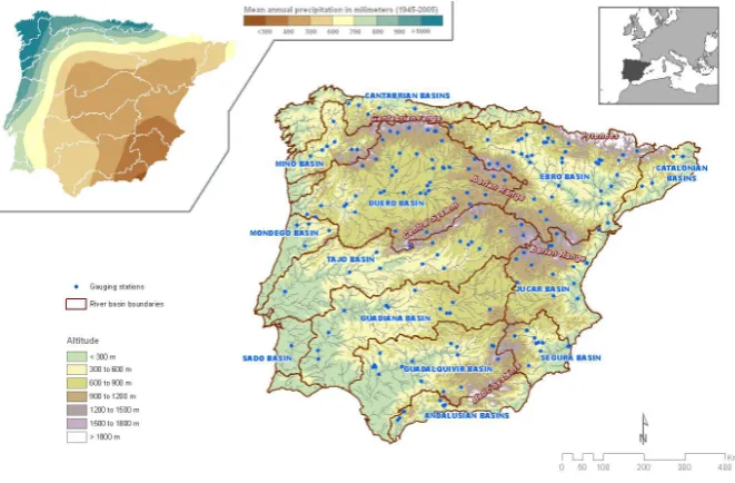
The IP covers 583 254 km2 and has a very contrasting re-lief. The mountain ranges mainly run from west to east, and in some cases reach altitudes of approximately 3000 m a.s.l., resulting in the region having the second highest mean alti-tude (637 m a.s.l.) in Western Europe. These mountains have influenced the river network and the spatial configuration of the major basins of rivers flowing towards the Atlantic Ocean (the Mi˜no, Duero, Tajo, Guadiana and Guadalquivir basins) and the Mediterranean Sea (the Segura, J´ucar and Ebro basins) (see Fig. 1). The location and topography of the IP, together with the effects of large atmospheric circu-lation patterns (L´opez-Bustins et al., 2008) generate a south-east to northwest gradient in annual precipitation (De-Castro et al., 2005; Gonz´alez-Hidalgo et al., 2011) (see Fig. 1). Precipitation is concentrated mainly in winter (40 % of an-nual precipitation), and varies from less than 300 mm yr−1 (in the southeast corner, e.g. the Murcia region) to more than 1500 mm yr−1 (in the northwest, e.g. the Galicia re-gion). These patterns cause large variability in the duration and frequency of droughts among the various regions of the IP (Rico-Amor´os, 2004; Vicente-Serrano, 2006b). Win-ter floods dominate the flow regime typical of MediWin-terranean rivers. Higher inter-annual variability of streamflow results in long supra-seasonal droughts (Boix et al., 2010).
River basins in the northern sector of the Atlantic wa-tershed produce abundant yields, with mean annual flows (measured at the most downstream streamflow gauges) of 10 570 hm3yr−1 (cubic hectometers) for the Mi˜no River,
basin, which has abundant flow (mean 12 279 hm3yr−1) that
is generated in the Cantabrian Range and the Pyrenees. The uneven distribution of water resources within the IP and the rising demand for water have resulted in conflicts among users and regions (Quiroga et al., 2011). The increasing fre-quency of drought events in the IP since the 1970s (Vicente-Serrano et al., 2006a; Iglesias et al., 2007) have resulted in the construction of a complex network of dams and chan-nels to optimize the use of available water resources. This is especially the case in the southern basins, where significant regulation capacity has been developed during the last 60 yr (Arroyo-Ilera, 2007). The intensive regulation of river sys-tems in the IP is reflected in an increase in the number of ma-jor reservoirs constructed during the 20th century (from 58 in 1900 to 1195 in 2000), which together account for a total storage capacity of 56 500 hm3(Berga-Casafont, 2003). This capacity is approximately equal to the mean annual stream-flow of the 8 major rivers of the IP (55 850 hm3yr−1).
3 Dataset and methodology
3.1 Streamflow records
To create a representative streamflow database for the en-tire IP, streamflow data from 1460 gauging stations located across the study area were obtained from water agencies of Spain (Centro de Estudios Hidrogr´aficos, Ag`encia Catalana de l’Aigua, Agencia Andaluza del Agua and Augas de Gali-cia) and Portugal (Sistema Nacional de Informac¸ˆao de Recur-sos H´ıdricos). Daily streamflow data for the IP were obtained from measurements of the daily water level at each gauging station. The monthly river discharge at each station was in-tegrated from the average daily discharge. We conducted our analysis using monthly data due to the characteristics of hy-drological droughts. Drought episodes are recognized to be difficult to pinpoint in time and space, the effects grow slowly in magnitude and their impact can accumulate over long pe-riods of time (Mishra and Singh, 2010). For these reasons we considered monthly data more suitable for drought charac-terization than daily data.
The quality and length of the series was highly variable. Only the longest and most complete records were used to represent the major basins throughout the IP. Each record had to cover at least 50 yr. The monthly streamflow series used covered the period from 1945 to 2005, with the aim of including any changes resulting from the intensive river reg-ulation that took place in the second half of the 20th century. In total, 187 monthly streamflow series were selected, based on their record length and the percentage of data gaps. Time series with 10 % or more of the data missing for the total pe-riod of the series were excluded. Infilling of missing data was performed by linear regression analysis, and flow records at neighboring stations were used as the independent variables. The minimum Pearson’s correlation coefficient between the
series in the model was set at R=0.8. More details about the creation and validation of the database are provided in Lorenzo-Lacruz et al. (2012).
3.2 Standarization of streamflow series
To obtain a hydrological index that enabled comparison of streamflow series in time and space, regardless of the mag-nitude of the series and the river regimes involved, we trans-formed the monthly streamflow series into standardized z-scores. It is very common that hydrological series are not nor-mally distributed, and consequently must be adjusted to other probability distributions (G´amiz-Fortis et al., 2010; Vicente-Serrano et al., 2011) to facilitate standardization. Several streamflow indices have recently appeared in the literature (e.g. Shukla and Wood, 2008; Nalbantis and Tsakiris, 2009); however, the accuracy of the indices is limited due to the ad-justment to a unique probability distribution. In order to ob-tain a reliable standardized streamflow index (SSI) that en-compasses the large variability in the statistical properties of the monthly data, the series were fitted to the most suit-able probability distribution, according to the minimum or-thogonal distance (MD) between the sample L-moments at site i and the L-moment relationship for a specific distri-bution selected from the general extreme value (GEV), the Pearson type III (PIII), the log-logistic, the lognormal, the generalized Pareto and the Weibull distributions. For each streamflow series we calculated six SSI series, correspond-ing to each of the six probability distributions used, and we selected the one which showed the most robust adjustment (minimum orthogonal distance in a L-moments diagram). OnceF (x)(the cumulative distribution function) is identi-fied, the SSI (inz-scores) can easily be calculated following, for example, the classical approximation of Abramowitz and Stegun (1965). More datails about the SSI calculation can be found in Vicente-Serrano et al. (2011).
3.3 Regionalization
Fig. 1. The Iberian Peninsula: topography and location of the gauging stations used in the study distributed by mayor basins. Upper left
corner: distribution of the mean annual precipitation for the study period (1945–2005). Upper right corner: Iberian Peninsula location map.
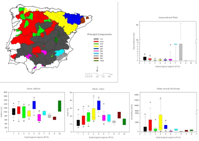
2006; Kahya et al., 2008; Mor´an-Tejeda et al., 2011; Peter-son et al., 2011); it allows for retention of common features of the samples and identification of local peculiarities. Using this approach we obtained an additional non-correlated set of variables that were the linear combinations of the originals. The components were rotated to redistribute the explained variance and to obtain more physically robust patterns. This transformation was done by varimax rotation (White et al., 1991), which is the most recommended approach for this task (Jollife, 1990). The coefficients of such combinations (“loading factors”) represent the correlations of the princi-pal component with each original variable (the SSI series for each gauging station). Identification of the maximum load-ing factor enabled us to classify each gaugload-ing station into the resulting groups. Drought analysis and characterization were therefore based on the hydrological regions defined by the PCA. The selection of the principal components was based on the explained variance. In order to give consideration to a new principal component it must explain more than 1.5 % of the total variance. We also included information about the properties of the catchments represented by each PC; the physiographic characteristics of the basins included in each hydrological region were derived using a 100 m digital ele-vation model (mean altitude and mean slope of the basins), whereas the mean annual discharge and the Impoundment Ratio were calculated using water agencies data.
3.4 Drought characterization
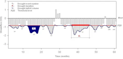
In order to define drought events, a threshold level that does not vary in time and space, since records are standardized, was applied to the SSI series (Yevjevich, 1967; Tallaksen et
al., 1997; Hisdal et al., 2004; Tallaksen et al., 2009). The threshold level was set up at the 20 % of cumulative proba-bility (SSI =−0.84, given the standardized characteristic of the variable), and a drought event was thus registered when the monthly SSI fell below that level (van Loon et al., 2010). Based on this threshold, streamflow droughts were character-ized using the following parameters: (i) drought duration, (ii) drought magnitude, and (iii) drought-affected area (Fig. 2). (i) Drought duration: The duration dn of a given drought
eventen was defined as the consecutive and uninterrupted
time steps (one or more months) with an observed streamflow (SSI) below P20 at a specific gauging station. (ii) Drought magnitude: The accumulated deficit volumevn was defined
as the sum of the deficit volumes generated during an uninter-rupted number of months (dn), delimiting a drought eventen
Fig. 2. Drought definition sketch.
3.5 Correlation analysis
In the last section of the study we performed several correla-tion analyses between the principal components and various factors, which we considered appropriate to explain the hy-drological regionalization obtained in Sect. 4.1. Among these factors we included the variability of the North Atlantic Os-cillation (NAO), which has been proved to be the dominant pattern influencing streamflows in western Europe and in the Iberian Peninsula (Lorenzo-Lacruz et al., 2011), and the Western Mediterranean Oscillation (WeMO) (Mart´ın-Vide and L´opez-Bustins, 2006). Since streamflow droughts are re-lated to climate variability, we correre-lated a meteorological drought index, the Standardized Precipitation Index (McKee at al., 1993), with selected principal components to assess the time lags between meteorological droughts and stream-flow droughts. Finally we correlated the streamstream-flow of the Tajo–Segura water transfer (in SSI units) with the SSI evo-lution of the Segura basin to estimate its dependence on the water transferred.
4 Results
4.1 Streamflow-related homogeneous regions
Figure 3 shows the distribution of the sub-basins most cor-related with each principal component (PC) obtained. The boxplots indicate the range of values of the impoundment ratio (storage capacity upstream of the gauging station di-vided by the long-term mean annual runoff; Batalla et al., 2004), elevation, slope and annual discharge for the sub-basins belonging to each PC. We considered the first ten PCs, which together explained 60 % of the total variance (evolu-tion of the SSI at 187 gauging sta(evolu-tions); this was considered to represent a reasonable portion of the very high variability of the streamflow behavior, since the variability of Iberian monthly precipitation was summarized into 6 components (70 % of the variance, Vicente-Serrano et al., 2006b). The largest region (41.8 % of the study area and 49 cachtments) included catchments most correlated with principal compo-nent 1 (PC1). It showed a clear spatial pattern that included
sub-basins corresponding to the upper reaches of the Duero and Tajo rivers, the Jal´on-Jiloca river system in the south-western sector of the Ebro basin, and most of the Guadiana, Guadalquivir and J´ucar basins. This region is characterized by moderate water yields and catchment slopes, and has a high degree of regulation. The impoundment ratio for the re-gion indicates that the regulation capacity exceeds the annual water yield in many sub-basins. PC2 was mainly associated with a large proportion of the middle and lower reaches of the Mi˜no, Duero and Tajo rivers, represented 26.8 % of the study area and encompassed 46 cachtments. Basins in this re-gion are located on the north Iberian plateau (>900 m a.s.l.), where exposure to the influence of Atlantic Ocean air masses is closely related to abundant flows. The catchments corre-lated with PC3 occupied 6.6 % of the study area and included 24 sub-basins that were interspersed with those belonging to PC2. They corresponded to headwaters of the Mi˜no and Duero river basins and some of their tributaries, which are fed by the Central System and the Mountains of Leon (the westernmost foothills of the Cantabrian Range). This region has a very low level of regulation and moderate streamflow volumes. The sub-basins most correlated with PC4 covered 12.7 % of the study area (25 cachtments), and included the majority of the Cantabrian basins, and the main course of the Ebro River and its tributaries flowing from the Atlantic Pyre-nees. PC4 was characterized by abundant water yields, and the high altitude and steep slopes of the Cantabrian basins, the headwaters of the Ebro River and the Pyrenean tribu-taries. The sub-basins represented by PC5 (5.5 % of the study area and 14 cachtments) corresponded to river systems flow-ing from the central Pyrenees. This region has the steepest slopes and the highest altitudes. PC6 represented the Andalu-sian basins and the right bank tributaries of the Guadalquivir basin. This region covers 1.5 % of the study area (13 cacht-ments), and is characterized by low discharges and a con-siderable degree of regulation. PC7 and PC8 were correlated with contrasting parts of the Segura basin. PC7 (1.64 % of the study area and 5 cachtments) was related to sub-basins that directly receive water transferred from the headwaters of the Tajo basin, while PC8 (1.7 % of the study area and 5 cacht-ments) represents the Segura basin sub-systems not directly influenced by water transfer. Both PC7 and PC8 were charac-terized by changes resulting from extreme water regulation. PC9 encompassed 1 % of the study area and included all of the Catalonian basins (4). PC10 (0.5 % of the study area and 2 cachtments) was correlated with the most upstream stations of the Tajo and J´ucar rivers.
4.2 Temporal evolution of drought
Fig. 3. Spatial distribution of the highest loadings sub-basin from each principal component. Box-plots show the mean altitude, mean slope,
mean annual discharge and the impoundment ratio of every sub-basin included in each hydrological region.
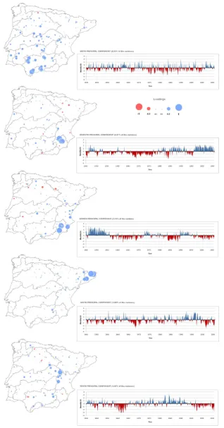
periods. Two contrasting periods were evident in the tem-poral evolution of PC1: a humid period from 1945 to 1980 with sporadic drought episodes during the 1950s, and a fol-lowing dry period that lasted until 2005. Within the latter, three main droughts occurred: one in the early 1980s, one in the middle of the 1990s that lasted for 5 yr (the longest and most severe hydrological drought in the IP since records be-gan), and one at the beginning of the 21st century (with 2003 having the driest conditions). The correlations between this temporal signature and the streamflow series were very high for those rivers with headwaters and upper reaches located in the southern Iberian range (the Tajo, J´ucar, Guadiana rivers, and the Jal´on-Jiloca system).
PC2 explained 11.56 % of the variance and was associated with a relatively high temporal frequency in the occurrence of dry and moist periods, which occurred almost annually. Two contrasting periods were also observed for this PC. The first (from 1945 to 1965) was associated with repeated in-tense and intra-annual droughts that occurred almost every year, while the second (1970s to present) was associated with a reduction in the number and intensity of drought periods. This pattern was highly correlated with the lower reaches of the Mi˜no River, the right bank tributaries of the Duero basin and the lower Tajo basin.
PC3 explained 9.5 % of the variance, and also showed a high temporal frequency between dry and moist periods. The temporal evolution of PC3 showed an increase in the frequency, duration and intensity of drought episodes after the 1970s, with the most notable occurring in 1992–1994 and 2003–2005. The low reaches of the Duero basin, almost
the entire Mondego basin, and the systems flowing from the Mountains of Le´on (the Eria and Tera rivers in the Duero basin, and the Sil and Cabrera rivers in the Mi˜no basin) were highly correlated with this PC.
PC4 explained 8.81 % of the total variance. Although it was associated with a moderate frequency in the succession of dry and moist periods, its temporal evolution showed a predominance of drought episodes (which were common) over humid periods. The most intense droughts occurred in 1949, 1955 and 1990. The Cantabrian basins were moder-ately correlated with this component, whereas correlations increase for the main course of the Ebro River and its left bank tributaries flowing from the eastern (Atlantic) Pyrenees (the Ega, Arga and Irati rivers).
PC5 explained 4.73 % of the variance and was character-ized by similar frequencies of dry and moist periods. Six ma-jor drought episodes occurred during the study period: 1948– 1950, 1957–1959, 1980, 1983–1986, 1988–1992 and 1998– 1999. Rivers flowing from the central Pyrenees were moder-ately (the Arag´on River system) or highly (the Segre–Cinca system) correlated with this PC.
Fig. 4. Spatial distribution of the PCA loadings for the first principal components (1st to 5th), and temporal evolution of the principal
the IP, moderately high for the right bank tributaries of the Guadalquivir River, and strong in the case of the Andalusian basins.
PC7 explained 2.67 % of the variance, and was only repre-sentative of the evolution of the SSI in the Mundo River sys-tem (Segura basin). The sys-temporal evolution of PC7 showed a low frequency between dry and humid periods, and two contrasting periods were evident. From 1945 to 1978 the droughts were frequent, long lasting and of intermediate in-tensity, while from 1978 to 2005 the droughts were much less frequent, and moist periods predominated.
PC8 explained 2.15 % of the variance and was represented by the right bank tributaries and the low reaches of the Segura River. Its evolution reflected a low frequency in the succes-sion of dry and humid periods, which were interspersed. The moist period lasting from 1945 to 1955 was followed by a drought period from 1955 to 1973, then by a short moist pe-riod (1973–1975), and finally a dry pepe-riod that lasted until 1990. The period from 1990 to 1995 was moist (substantial discharges occurred), and was followed by another dry pe-riod that lasted until 2005.
PC9 also showed a low temporal frequency between dry and moist periods. Drought episodes were common during the study period, but two major drought episodes occurred, from 1965 to 1968 and from 1999 to 2004, and were directly correlated with the Catalonian basins, especially those in the north. PC10 was moderately correlated with the headwaters of the Tajo and J´ucar basins, and was associated with a low frequency between dry and moist periods; major multi-year droughts were recorded from 1959 to 1964, and from 1996 to 2005.
4.3 Drought characteristics
Following the methodology shown in Sect. 3.4, we derived the duration and magnitude of each delimited streamflow drought event. In this way, we obtained series of drought duration and magnitude for each PC. Figure 6 shows the cumulative absolute frequencies of drought duration and magnitude for the drought events recorded in each region; these are arranged from shortest to longest in the case of drought duration, and from smallest accumulated deficit to largest accumulated deficit in the case of drought magni-tudes. Marked differences were found among regions. With respect to drought characteristics, three main groups were ev-ident. The first, integrated solely by PC1, had few drought episodes, although these were characterized by long dura-tion and high magnitude. The occurrence of 7 hyper-annual drought episodes exceeding one year in duration, and two exceptional droughts exceeding 5 yr in duration, showing that the PC1 hydrological region had the most pronounced droughts over time and consequently registered the greatest accumulated streamflow deficits. The second group in rela-tion to drought durarela-tion was integrated by PCs 2, 5 and 7– 10. All these had a large number of dry episodes (70–100),
with maximum durations of 25–35 months. Drought magni-tudes are closely related to the duration of drought episodes, and thus the internal composition of the group regarding the accumulated deficits is almost the same as for duration. The third group of regions in relation to drought events was in-tegrated by PCs 3, 4 and 6. All of these had more than 100 short drought episodes that never exceeded 20 months in du-ration, which generated minor SSI deficits and low drought magnitudes.
4.4 Changes in duration and magnitude
Table 1 summarizes the drought characteristics (duration and magnitude) of each PC for the periods 1945–1974 and 1975– 2005. For PC1 there was a clear increase in the number of drought events in the second period (n=27) relative to the first (n=21). The drought duration and magnitude also increased considerably in the second period, to an average drought duration of 10 months and an accumulated deficit of 15 SSI units. The maximum duration increased from 15 to 66 months, and the maximum accumulated SSI deficit in-creased from 16 to 113 SSI units. For PC2 there was a slight increase in the number of drought events from 1975 to 2005, but a decrease occurred in the average and maximum dura-tion and magnitude of the drought episodes. For PCs 3–6 the patterns were very similar, all showing a moderate increase in the average duration and magnitude of drought events in the second half of the study period. However, with the excep-tion of PC5, the maximum drought duraexcep-tion and magnitude increased from 1975 to 2005. For PC7 there was an increase in the number of drought episodes, although substantial de-creases were observed in the average drought duration and magnitude during the second period. For PC8 the pattern was similar in the two periods, although the maximum duration and magnitude increased considerably during the second pe-riod. For PC9 there was a slight decrease in the average du-ration and magnitude of drought episodes, whereas both the maximum duration and magnitude increased. For PC10 the pattern was similar in the two periods, although the maxi-mum duration and magnitude decreased somewhat.
4.5 Drought spatial coverage
Fig. 5. Spatial distribution of the PCA loadings for the first principal components (6th to 10th), and temporal evolution of the principal
Table 1. Streamflow drought duration and accumulated deficits for two contrasted periods (1945–1974 and 1975–2005) for each principal
component.
1945–1974 1975–2005 Periods comparison
Mean Max. Mean Max. Mean Max. Mean Max. 1975–2000 respect to 1945–1974
duration duration Magnitude Magnitude duration duration Magnitude Magnitude Mean Max. Mean Max.
(months) (accumulated SSI deficit) (months) (accumulated SSI deficit) duration duration Magnitude Magnitude
PC1 3.7 15.0 2.0 16.4 9.8 66.0 9.5 113.2 Increase Increase Increase Increase PC2 4.8 26.0 5.1 34.1 3.6 9.0 2.0 9.1 Decrease Decrease Decrease Decrease PC3 2.7 8.0 1.8 8.3 4.1 17.0 3.5 18.4 Increase Increase Increase Increase PC4 2.9 11.0 2.2 12.3 3.3 18.0 2.6 15.5 Increase Increase Increase Increase PC5 3.0 19.0 2.3 27.4 4.6 21.0 3.8 23.0 Increase Increase Increase Decrease PC6 2.9 10.0 1.8 8.2 4.2 18.0 3.7 17.4 Increase Increase Increase Increase PC7 8.4 33.0 6.2 39.1 3.4 25.0 2.7 26.9 Decrease Decrease Decrease Decrease PC8 4.1 16.0 3.0 14.5 4.7 33.0 3.4 43.1 Increase Increase Increase Increase PC9 4.7 12.0 3.7 21.0 4.1 15.0 3.1 22.9 Decrease Increase Decrease Increase PC10 4.3 26.0 3.8 49.0 4.6 21.0 3.3 22.1 Increase Decrease Decrease Decrease
Fig. 6. Left: duration (in months) of the drought episodes (from shortest to longest event). Right: magnitude (in accumulated SSI deficits) of
the drought episodes (from minor to major).
1976, when the drought-affected area exceeded 40 % of the study area. The third and longest stage lasted from 1980 to 2005. During this stage the drought-affected area often ex-ceeded 50 % of the study area, and in 1981, 1992, 1993, 1995 and 2000 the peak area affected exceeded 70 %. The area affected by severe drought during this stage followed a similar pattern to that of the first stage, although occurrences of the affected area exceeding 30 % were restricted to 1992, 1993, 1995 and 2000. The shapes of the graphs of drought and severe drought follow a similar pattern because their oc-currences were closely related. However, the slopes of the curves showed a stationary behavior in terms of the percent-age area affected by severe droughts (SSI<−1.65), whereas the percentage area affected by droughts (SSI<−0.84) in-creased from 1945 to 2005, particularly in the later years.
[image:10.595.48.550.99.310.2]The analysis above shows the great spatial complexity of droughts in the IP. Thus, individual drought episodes can have very different spatial patterns in terms of onset, intensity, spatial propagation and area affected. Figures 8 and 9 illustrate this complexity through examples show-ing very different spatiotemporal evolutions of two drought episodes in the IP. Figure 8 shows the spatial coverage of the sub-basins affected by drought and severe drought during
Fig. 7. Temporal evolution of the percentage of affected area by
streamflow droughts. The grey line depicts discharges under−0.84 of the standardized streamflow series. The red line depicts dis-charges under−1.65.
[image:10.595.310.548.443.517.2]Fig. 8. Spatial coverage of the affected areas during the 1948–1949
drought. Dark grey depicted moderate drought conditions and red depicted severe drought conditions.
[image:11.595.51.285.62.335.2]severe drought conditions throughout most of the Ebro basin. This transboundary drought extended throughout the west-ern sector of the IP, seriously affecting the Duero, Tajo and Guadiana basins between February 1949 and June 1949. Af-ter reaching a second peak of maximum extent during Au-gust 1949, the drought weakened in the autumn of 1949 and had almost disappeared by December 1949. Figure 9 shows the spatial propagation of the drought episode that af-fected the IP in 1992 and 1993. The core area of this drought episode was the middle and lower reaches of the southern-most basins (Guadiana, Guadalquivir and J´ucar) of the IP. Its genesis was in the autumn of 1991, and the area affected by water shortages rapidly expanded northwards, encompassing the middle reaches of the Duero, Tajo and Ebro basins by December 1991. Severe drought conditions had established over much of the major northern basins (Mi˜no, Duero and Ebro) by February 1992. A decline in the area affected by drought occurred in the following months, although drought conditions were present in several sub-basins during summer 1992, especially those in the J´ucar basin. The spatial extent of the drought expanded in December 1992, and was con-centrated mainly in the southern basins. A second peak of maximum drought coverage occurred in late winter and early spring 1993, when more than 80 % of sub-basins were under drought conditions. After April 1993 the drought weakened in the northern sector of the IP, and progressively disappeared
Fig. 9. Spatial coverage of the affected areas during the 1992–1993
drought. Dark grey depicted moderate drought conditions and red depicted severe drought conditions.
during summer and autumn 1993. Both of these examples highlight the complexity of hydrological droughts and the very different spatiotemporal patterns of the phenomenon in the IP.
5 Discussion
For example, L´opez-Moreno et al. (2009) assessed the ef-fects of a large transboundary dam between Spain and Por-tugal on hydrological droughts in the Tagus basin (Iberian Peninsula; IP), showing how the nature of droughts had ex-perienced severe changes downstream of the Alc´antara Dam. These changes are associated with an increase in both the duration and the magnitude of drought episodes as a conse-quence of the dam management, with implications for the availability of water resources downstream affecting the Por-tuguese part of the basin. In the headwaters of the Tagus basin, Lorenzo-Lacruz et al. (2010) also showed how dam operation for irrigation purposes and water transfer has al-tered the natural regime of the river and increased the du-ration and magnitude of low flows downstream, with impli-cations on the water availability and quality in the medium course of the river. This has been a great source of conflicts between ecologists, agrarian organizations of the basin and the water managers. Thus, independently of the origin of the streamflow droughts (climatic or driven by the water man-agement), they cause negative impacts and stress the need of analyzing in depth the impacts of water management on hy-drological droughts. The results of the studies cited above are even more interesting than those focused on “natural” basins since operational water management recommendations may be derived for the results. All the mentioned studies indicated that water management associated with the exploitation of reservoirs is responsible for the temporal aggregation and ag-gravation of hydrological droughts downstream the dams.
The objectives of our study were focused on the character-ization of hydrological droughts in the IP, independently of the regulation level of the rivers, with the scope limited to the assessment of the changes observed in the duration and mag-nitude of the streamflow droughts. However, since the reality is that Iberian rivers are mostly regulated and affected by di-verse human activities, the inclusion of regulated systems is necessary to encompass the variability and the impacts in-duced by dams on the changes in the streamflow droughts. Thus, the analysis allows the definition of independent hy-drological regions with distinctive drought characteristics (it is noteworthy that the most severe and lasting droughts were observed in those basins with a high degree of regulation).
Our analysis was based on a hydrological regionalization, using principal component analysis applied to 187 series of the SSI (Vicente-Serrano et al., 2011) distributed homoge-nously across the entire IP. We used an alternative approach to define homogeneous hydrological regions for the specific analysis of their responses to droughts, since the most ex-tended methodology used with this purpose is based on clus-ter analysis (Stahl and Demuth, 1999; Fleig et al., 2011). The use of a streamflow drought index (the SSI) enabled us to perform a PCA using standardized variables, compa-rable in time and space, and thus identify regions with ho-mogeneous streamflow (high and low) characteristics. The efficacy of this method has been proved in several regions worldwide (Johnston and Shmagin, 2008; Kahya et al., 2008;
Peterson et al., 2011). The PCA performed quite well in our case, as the regionalization obtained showed highly coher-ent geographical patterns with well-defined natural bound-aries (mainly mountain ranges). The Iberian Plateau is di-vided in two by the Central System, which also originates a separation between PC 1 and 2. The Cantabrian and the Iberian Ranges separate the Plateau unit (PC1 and PC2) from the Ebro Valley (PC4). A different coastal influence in the Pyrenees creates a distinction between the western Pyre-nean basins (Atlantic Sea influence; PC4), the central basins (with the highest altitudes; PC5) and the Catalonian basins (opened to the Mediterranean Sea influence; PC9). Neverthe-less, the spatial variability of streamflow droughts in the IP is greater than the observed variability of climatic droughts; the latter was summarized in just 6 PCs (Vicente-Serrano, 2006a, b). However, the first 10 PCs only explained 60 % of the total variance. This highlights the great complexity and number of factors that generate the water yield in a basin (Krasovskaia et al., 1994; Fleig et al., 2011). Besides climate variability and the physiographic complexity of the differ-ent basins, the water managemdiffer-ent model established in the IP, which is based on the concept of “basin unity”, generates greater differences between the behavior of basins belonging to one basin water agency vs. to another (e.g. Confederaci´on Hidrogr´afica del Ebro versus Confederaci´on Hidrogr´afica del Duero). The different water management strategies imple-mented among agencies increase the complexity of the re-gionalization. Moreover, at the local scale the perturbations caused by pumping and extraction introduce even more com-plexity.
The general patterns reported here for the evolution and occurrence of streamflow droughts in the IP (with the dri-est decades being the 1950s, 1980s, 1990s and 2000s) are consistent with findings related to climatic droughts re-ported by Briffa et al. (1994), Maheras (1988) and Vicente-Serrano (2006a) for Europe, the Mediterranean region, and the IP, respectively. Our findings are also consistent with an analysis by Hannaford et al. (2011) of streamflow droughts that partially included the IP. These results also showed a high degree of consistency with the results presented in Lorenzo-Lacruz et al. (2012), where Iberian streamflow trends analysis was addressed using this same dataset.
recharge, and the multi-year regulation of dams within the basins concerned can cause temporal delays in the occur-rence of streamflow deficits with respect to the lack of pre-cipitation (Lorenzo-Lacruz et al., 2010). The relationship be-tween PC1 and precipitation in the southern parts of the Iberian Range (located near the headwaters of the Tajo, J´ucar and Guadiana rivers) exemplifies the delays noted above. We found a maximum correlation (R=0.76) between the stan-dardized precipitation index (SPI) for this area and PC1 at a 25-month time scale, demonstrating the multi-year depen-dence of streamflows on climatic conditions that cause long-lasting droughts in this hydrological region, which was also observed in Lorenzo-Lacruz et al. (2010). Moreover, the oro-graphic node that represents the southern Iberian Range is a critical zone for water management within the IP. This is because the southern Iberian Range acts to divert water be-tween the Ebro, Tajo and J´ucar basin headwaters, conditions the streamflow response to droughts in the middle and lower reaches of the basins correlated with PC1 (12.8 % of the ex-plained variance and 40.8 % of the study area), and deter-mines the quantity of water that can be transferred to the Se-gura basin. Of additional significance is the water demand of the coastal zone of the J´ucar basin, where the marked sea-sonal pattern in occupancy because of tourism exacerbates drought events during summer (Collins et al., 2009). The drought characteristics of the hydrological region defined by PC2 may be related to the Atlantic Ocean influence, which is the main source of humid air masses responsible for pre-cipitation in this region, and the high altitudes, which de-termine the snow and rainfall regimes characteristic of the headwaters of this region (Mor´an-Tejeda et al., 2011). The trend towards fewer intra-annual drought events in this re-gion (mainly the Duero basin) is closely related to the wa-ter regulation strategy, which increases river discharges dur-ing summer (avoiddur-ing the worse seasonal droughts durdur-ing the dry season) at the expense of reducing streamflows dur-ing winter and sprdur-ing. The PC3 basins interspersed with the PC2 hydrological region have a very low level of regulation; consequently, the climatic signal might be of great impor-tance in defining streamflow behavior. It is noteworthy that a significant negative correlation (R= −0.35,α <0.01) was evident between PC3 in winter and the winter NAO index. The hydrological region defined by PC4 is bounded by the orography of the Cantabrian, Pyrenean and Iberian ranges, which channel the northern humid air masses towards the Ebro Valley. Thus, northern flows from the Cantabrian Sea feed the Cantabrian basins, the Atlantic Pyrenean basins and the Ebro headwaters. The latter two are the major contrib-utors to streamflow in the main course of the Ebro River (Batalla et al., 2004), and consequently determine the con-ditions in the upper reaches of the Ebro basin (which are reg-ulated by the Ebro reservoir in the headwaters) and control drought occurrence downstream in the lower reaches. Ac-cording to Mart´ın-Vide and L´opez-Bustins (2006), the posi-tive phase of the Western Mediterranean Oscillation (WeMO)
determines rainfall in the zones adjacent to the Gulf of Bis-cay, which is reflected in the streamflow behavior of the hy-drological region defined by PC4, and accounts for the sig-nificant positive correlation between PC4 in winter and the winter WeMO index (R=0.52). The drought-related region associated with PC5 is characterized by mountainous rivers, which are related to the high altitude and steep slopes. In this area snowmelt plays an important hydrological role and causes a significant delay in the SSI response to climatic con-ditions (between 2 and 10 months, depending on the level of regulation) (Vicente-Serrano and L´opez-Moreno, 2005). The streamflow drought characteristics of the PC6 hydrolog-ical region may be related to the small area involved and the low altitude of the catchments. These factors result in fre-quent but short drought episodes because of the ephemeral regime of the streams, which usually have moderate or high streamflows during the wet season but are dry during the remainder of the year (Liquete et al., 2005). The reduction in drought episodes in the hydrological region represented by PC7 reflects the dependence of this area on water trans-ferred from the headwaters of the Tagus River. Since 1979 the Tajo–Segura water transfer has transferred an average of 331 hm3 of water per year for irrigation purposes, and for urban supply to a population of 2.5 million (Rico-Amor´os, 2004). This dependence is evident in the highly significant correlation (R=0.65,α <0.01) between PC7 and the stan-dardized streamflow series for the water transfer. However, a clear relationship between PC7 and PC8 was found. Since the water transfer began, aquifer overexploitation for irriga-tion and leisure purposes has occurred in the Segura basin, including many sub-basins belonging to the PC8 hydrolog-ical region, leading to depletion of the aquifers (Custodio, 2002) and an increase in the number of drought episodes. No clear causalities were found to explain the different drought typologies observed for the PC9 and PC10 hydrological re-gions.
Two contrasting patterns in the temporal evolution of the spatial extent of drought-affected areas were observed. For moderate droughts there was a trend toward increase in the spatial extent, which may be related to the observed trend toward decreasing precipitation during specific months (Xo-plaki et al., 2004; Mourato et al., 2010; Gonz´alez-Hidalgo et al., 2011), water management processes, and increasing use of water for activities including irrigation and urban sup-ply (Rico-Amor´os, 2004). In contrast, the size and number of areas affected by severe droughts (under 5th percentile) has remained relatively stable during the last 60 yr. Expan-sion of these areas has been moderated by water regulation strategies to provide ecological flows that maintain riparian ecosystems, at the expense of suffering alterations to their composition and structure (Boix et al., 2010).
The heterogeneity observed in the genesis and spatial propagation of droughts over time confirms the view that no two droughts are identical, and that droughts are not static (Wilhite, 2005). We observed that the core area of a drought can shift, and its spatial extent can expand and contract until its disappearance. Consequently, the monitoring and assess-ment of drought episodes is of great relevance to the devel-opment of early warning systems and management strategies to mitigate the impacts of droughts.
6 Conclusions
This study provides a comprehensive analysis of the spa-tiotemporal characteristics of streamflow droughts in the Iberian Peninsula during the second half of the 20th century. It represents a novel contribution since we used an extensive spatiotemporal dataset that had not previously been used for this purpose or spatial context. The dataset may be a useful aid for water managers and politicians, and the methods used were based on standard procedures applied in recent years to the characterization of streamflow droughts.
The PCA performed well, and revealed quite consistent spatial patterns related to the regionalization. The method-ology was capable of pinpointing and delimiting drought episodes and the characteristics associated with them. This approach enabled us to define various drought typologies having contrasting durations and magnitudes. The results show that in terms of drought duration and magnitude the sit-uation is becoming worse in the majority of the hydrological regions delimited by the PCA. The area affected by droughts is also increasing, which may threaten the maintenance of current water supplies and consumptive water uses in the IP. We also found substantial spatial heterogeneity in the gen-esis, evolution and disappearance of streamflow droughts, highlighting the great complexity of this phenomenon. This complexity is exacerbated in the IP by the highly variable cli-mate, the complex orography, the extensive water regulation systems, and the contrasting water demands among regions.
Acknowledgements. We would like to thank the Centro de Estu-dios Hidrogr´aficos (CEDEX), Sistema Nacional de Informac¸ˆao de Recursos H´ıdricos (SNIRH), Ag`encia Catalana de l’Aigua, Agencia Andaluza del Agua and Augas de Galicia for providing the hydrological data used in this study. This work has been supported by a pre-doctoral fellowship by the Arag´on Government (Spain), and by the research projects CGL2006-11619/HID, CGL2008-01189/BTE, CGL2011-27574-C02-02 and CGL2011-27536 financed by the Spanish Commission of Science and Technology and FEDER, EUROGEOSS (FP7-ENV-2008-1-226487) and AC-QWA (FP7-ENV-2007-1-212250) financed by the VII Framework Programme of the European Commission, and “La nieve en el Pirineo Aragon´es y su respuesta a la variabilidad clim´atica” and “Efecto de los escenarios de cambio clim´atico sobre la hidrolog´ıa superficial y la gesti´on de embalses del Pirineo Aragon´es” financed by “Obra Social La Caixa” and the Arag´on Government.
Edited by: D. Mazvimavi
References
Abramowitz, M. and Stegun, I. A.: Handbook of mathematical func-tions, Dover Publicafunc-tions, New York, 1965.
Albiac, J., Uche, J., Valero, A., Serra, L., Meyer, A., and Tapia, J.: The economic unsustainability of the Spanish National Hydro-logical Plan, Int. J. Water Resour. D., 19, 437–458, 2003. Arroyo-Ilera, F.: Territorio, tecnolog´ıa y capital, La regulaci´on
hidroel´ectrica de los r´ıos espa˜noles [1900–1970], Treballs de la Societat Catalana de Geograf´ıa, 63, 39–70, 2007.
Berga-Casafont, L.: Presas y embalses en la Espa˜na del siglo XX, Revista de Obras P´ublicas, 3438, 37–40, 2003.
Batalla, R. J., G´omez, C. M., and Kondolf, G. M.: Reservoir-induced hydrological changes in the Ebro River basin [NE Spain], J. Hydrol., 290, 117–136, 2004.
Boix, D., Garc´ıa-Berthou, E., Gasc´on, S., Benejam, L., Torn´es, E., Sala, J., Benito, J., Munn´e, A., Sol´a, C., and Sabater, S.: Re-sponse of community structure to sustained drought in Mediter-ranean rivers, J. Hydrol., 383, 135–146, 2010.
Briffa, K. R., Jones, P. D., and Hulme, M.: Summer moisture variability across Europe, 1892–1991: an analysis based on the Palmer drought severity index, Int. J. Climatol., 14, 475–506, 1994.
Collins, R., Kristensen, P., and Thyssen, N.: Water resources across Europe – confronting water scarcity and drought, European En-vironmental Agency, 2009.
COPA-COGECA: Assessment of the impact of the heat wave and drought of summer 2003 in agriculture and forestry, Committee of Agricultural Organizations in the European Union, 2003. Custodio, E.: Aquifer overexploitation: what does it mean?,
Hydro-geol. J., 10, 254–277, 2002.
De-Castro, M., Mart´ın-Vide, J., and Alonso, S.: El clima de Espa˜na: pasado, presente y escenarios de clima para el siglo XXI, Im-pactos del cambio clim´atico en Espa˜na, Ministerio Medio Ambi-ente: Madrid, 2005.
Dracup, J. A., Lee, K. S., Paulson Jr., E. G.: On the statistical char-acteristics of drought events, Water Resour. Res., 16, 289–296, 1980.
Fleig, A. K., Tallaksen, L. M., Hisdal, H., and Demuth, S.: A global evaluation of streamflow drought characteristics, Hydrol. Earth Syst. Sci., 10, 535–552, doi:10.5194/hess-10-535-2006, 2006. Fleig, A. K., Tallaksen, L. M., Hisdal, H., and Hannah, D. M.:
Re-gional hydrological drought in north-western Europe: linking a new Regional Drought Area Index with weather types, Hydrol. Process., 25, 1163–1179, 2011.
G´amiz-Fortis, S. R., Esteban-Parra, M. J., Trigo, R. M., and Castro-D´ıez, Y.: Potential predictability of an Iberian river flow based on its relationship with previous winter global SST, J. Hydrol., 385, 143–149, 2010.
Gonz´alez-Hidalgo, J. C., Brunetti, M., and De-Luis, M.: A new tool for monthly precipitation analysis in Spain: MO-PREDAS database [monthly precipitation trends December 1945–November 2005], Int. J. Climatol., 31, 715–731, 2011. Gudmundsson, L., Tallaksen, L. M., Stahl, K., and Fleig, A.
K.: Low-frequency variability of European runoff, Hydrol. Earth Syst. Sci., 15, 2853–2869, doi:10.5194/hess-15-2853-2011, 2011.
Hannaford, J., Lloyd-Hughes, B., Keef, C., Parry, S., and Prud-homme, C.: Examining the large-scale spatial coherence of Eu-ropean drought using regional indicators of precipitation and streamflow deficit, Hydrol. Process., 25, 1146–1162, 2011. Hisdal, H., Stahl, K., Tallaksen, L. M., and Demuth, S.: Have
streamflow droughts in Europe become more severe or frequent?, Int. J. Climatol., 21, 317–333, 2001.
Hisdal, H., Tallaksen, L. M., Clausen, B., Peters, E., and Gus-tard, A.: Hydrological drought characteristics, in: Hydrological Drougth – Processes and estimation methods for streamflow and groundwater, edited by: Tallaksen, L. M. and van Lanen, H. A. J., Developments in Water Science, Elsevier Science, 48, 139–198, 2004.
Iglesias, A., Garrote, L., Flores, F., and Moneo, M.: Challenges to manage the risk of water scarcity and climate change in the Mediterranean, Water Resour. Manage., 21, 775–788, 2007. Johnston, C. A. and Shmagin, B. A.: Regionalization, seasonality,
and trends of streamflow in the US Great Lakes Basin, J. Hydrol., 362, 69–88, 2008.
Jollife, I. T.: Principal component analysis: a beginner’s guide. Part I: Introduction and application, Weather, 45, 375–382, 1990. Kahya, E., Kalayci, S., Piechota, T. C.: Streamflow regionalization:
case study of Turkey, J. Hydrol. Eng., 13, 205–214, 2008. Kalayci, S. and Kahya, E.: Assessment of streamflow variability
modes in Turkey: 1964–1994, J. Hydrol., 324, 163–177, 2006. Krasovskaia, I., Arnell, N. W., and Gottschalk, L.: Flow regimes
in northern and western Europe: development and application of procedures for classifying flow regimes, in: Flow Regimes from International Experimental and Network Data (FRIEND), IAHS-AISH P., 221, 185–192, 1994.
Liquete, C., Arnau, P., Canals, M., and Colas, S.: Mediterranean river systems of Andalusia, southern Spain, and associated deltas: A source to sink approach, Mar. Geol., 222–223, 471– 495, 2005.
L´opez-Bustins, J. A., Mart´ın-Vide, J., and S´anchez-Lorenzo, A.: Iberia Winter rainfall trends based upon changes in teleconnec-tion and circulateleconnec-tion patterns, Global Planet. Change, 63, 171– 176, 2008.
L´opez-Moreno, J. I., Beguer´ıa, S., Vicente-Serrano, S. M., and Garc´ıa-Ruiz, J. M.: Influence of the North Atlantic Oscillation
on water resources in central Iberia: Precipitation, streamflow anomalies, and reservoir management strategies, Water Resour. Res., 43, W09411, doi:10.1029/2007WR005864, 2007. L´opez-Moreno, J. I., Vicente-Serrano, S. M., Beguer´ıa, S.,
Garc´ıa-Ruiz, J. M., Portela, M. M., and Almeida, A. B.: Dam effects on droughts magnitude and duration in a transboundary basin: The Lower River Tagus, Spain and Portugal, Water Resour. Res., 45, W02405, doi:10.1029/2008WR007198, 2009.
L´opez-Moreno, J. I., Vicente-Serrano, S. M., Zabalza, J., Beguer´ıa, S., Lorenzo-Lacruz, J., Azorin-Molina, C., and Mor´an-Tejeda, E.: Hydrological response to climate variability at different time scales: A study in the Ebro basin, J. Hydrol., 477, 175–188, 2013. Lorenzo-Lacruz, J., Vicente-Serrano, S. M., L´opez-Moreno, J. I., Beguer´ıa, S., Cuadrat, J. M., and Garc´ıa-Ruiz, J. M.: The im-pact of droughts and water management in various hydrological systems in the headwaters of the Tagus basin [central Spain], J. Hydrol., 386, 13–26, 2010.
Lorenzo-Lacruz, J., Vicente-Serrano, S. M., L´opez-Moreno, J. I., Gonz´alez-Hidalgo, J. C., and Mor´an-Tejeda, E.: The re-sponse of Iberian rivers to the North Atlantic Oscillation, Hy-drol. Earth Syst. Sci., 15, 2581–2597, doi:10.5194/hess-15-2581-2011, 2011.
Lorenzo-Lacruz, J., Vicente-Serrano, S. M., L´opez-Moreno, J. I., Mor´an-Tejeda, E., and Zabalza, J.: Recent trends in Iberian streamflows (1945–2005), J. Hydrol., 414, 462–475, 2012. Maheras, P.: Changes in precipitation conditions in the Western
Mediterranean over the last century, J. Climatol., 8, 179–189, 1988.
Mart´ın-Vide, J., and L´opez-Bustins, J. A.: The Western Mediter-ranean Oscillation and rainfall in the Iberian Peninsula, Int. J. Climatol., 26, 1455–1475, 2006.
McKee, T. B. N., Doesken, J., and Kleist, J.: The relationship of drought frecuency and duration to time scales, in: Eight Confer-ence on Applied Climatology, American Meteorological Society, Anaheim, CA, 179–184, 1993.
Mishra, A. K. and Singh, V. P.: A review of drought concepts, J. Hydrol., 391, 202–216, 2010.
Mor´an-Tejeda, E., L´opez-Moreno, J. I., Ceballos-Barbancho, A., and Vicente-Serrano, S.: River regimes and recent hydrological changes in the Duero basin [Spain], J. Hydrol., 404, 241–258, 2011.
Mourato, S., Moreira, M., and Corte-Real, J.: Interannual variability of precipitation distribution patterns in Southern Portugal, Int. J. Climatol., 30, 1784–1794, 2010.
Mudelsee, M.: Long memory of rivers from spatial aggregation, Water Resour. Res., 43, W01202, doi:10.1029/2006WR005721, 2007.
Nabaltis, I. and Tsakiris, G.: Assessment of hydrological drought revisited, Water Resour. Manage., 23, 881–897, 2009.
Obasi, G. O. P.: WMO’s role in the International Decade for natural disaster reduction, B. Am. Meteorol. Soc., 75, 1655–1661, 1994. Pandey, R. P., Mishra, S. K., Singh, R., and Ramasastri, K. S.: Streamflow Drought Severity Analysis of Betwa River System (India), Water Resour. Manage., 22, 1127–1141, 2008.
Peterson, H. M., Nieber, J. L., and Kanivetsky, R.: Hydrologic re-gionalization to assess anthropogenic changes, J. Hydrol., 408, 212–225, 2011.
Aus-tralian mountain ash cacthments, Hydrol. Process., 10, 877–892, 1996.
Preisendorfer, R. W.: Principal Component Analysis in Meteorol-ogy and Oceanography, Elsevier, New York, 425 pp., 1988. Quiroga, S., Garrote, L., Iglesias, A., Fern´andez-Haddad, Z.,
Schlickenrieder, J., de Lama, B., Mosso, C., and S´anchez-Arcilla, A.: The economic value of drought information for water man-agement under climate change: a case study in the Ebro basin, Nat. Hazards Earth Syst. Sci., 11, 643–657, doi:10.5194/nhess-11-643-2011, 2011.
Rico-Amor´os, A. M.: Sequ´ıas y abastecimiento de agua potable en Espa˜na, B. Asoc. Geogr. Esp., 37, 137–181, 2004.
Shukla, S. and Wood, A.: Use of a standardized runoff index for characterizing hydrologic drought, Geophys. Res. Lett., 35, L02405, doi:10.1029/2007GL032487, 2008.
Stahl, K.: Hydrological drought, A study across Europe, Phd thesis, Freiburg University, 2001.
Stahl, K. and Demuth, S.: Linking streamflow drought to the occur-rence of atmospheric circulation patterns, Hydrolog. Sci. J., 44, 467–482, 1999.
Tallaksen, L. M., Madsen, H., and Clausen, B.: On the definition and modelling of streamflow drought duration and deficit volumen, Hydrolog. Sci. J., 43, 15–33, 1997.
Tallaksen, L. M., Hisdal, H., and Van Lanen, H. A. J.: Space-time modelling of catchment scale drought characteristics, J. Hydrol., 375, 363–372, 2009.
Timilsena, J., Piechota, T. C., Hidalgo, H., and Tootle, G.: Five hun-dred years of hydrological drought in the upper Colorado river basin, J. Am. Water Resour. As., 47, 798–812, 2007.
UN Secretariat General: United Nations Convention to Combat Drought and Desertification in Countries Experiencing Serious Droughts and/or Desertification, Particularly in Africa, Paris, 1994.
van Loon, A. F., van Lanen, H. A. J., Hisdal, H., Tallaksen, L. M., Fendekov´a, M., Oosterwijk, J., Horv´at, O., and Machlica, A.: Understanding hydrological winter drought in Europe, IAHS Publ., 340, Wallingford, UK, 2010.
Vicente-Serrano, S. M.: Spatial and temporal analysis of droughts in the Iberian Peninsula [1910–2000], Hydrolog. Sci. J., 51, 83–97, 2006a.
Vicente-Serrano, S. M.: Differences in spatial patterns of drought on different time scales: An analysis of the Iberian Peninsula, Water Resour. Manage., 20, 37–60, 2006b.
Vicente-Serrano, S. M. and L´opez-Moreno, J. I.: Hydrological re-sponse to different time scales of climatological drought: an eval-uation of the Standardized Precipitation Index in a mountain-ous Mediterranean basin, Hydrol. Earth Syst. Sci., 9, 523–533, doi:10.5194/hess-9-523-2005, 2005.
Vicente-Serrano, S. M., L´opez-Moreno, J. I., Beguer´ıa, S., Lorenzo-Lacruz, J., Azorin-Molina, C., and Mor´an-Tejeda, E.: Accurate computation of a Streamflow Drought Index, J. Hydrol. Eng., 17, 318–332, doi:10.1061/(ASCE)HE.1943-5584.0000433, 2011. Wen, L., Rogers, K., Ling, J., Saintilan, N.: The impact of river
reg-ulation and water diversion on the hydrological drought charac-teristics in the Lower Murrumbidgee River, Australia, J. Hydrol., 405, 382–391, 2011.
White, D., Richman, H., and Yarnal, B.: Climate regionalization and rotation of principal components, Int. J. Climatol., 11, 1–25, 1991.
Wilhite, D. A.: Drought and water crises, Science, technology, and management issues, Taylor and Francis, 406 pp., 2005. Wilhite, D. A. and Glantz, M. H.: Understanding the drought
phe-nomenon: the role of definitions, Water Int., 10, 111–120, 1985. Wilhite, D. A., Svoboda, M. D., and Hayes, M. J.: Understanding the complex impacts of drought: A key to enhancing drought mit-igation and preparedness, Water Resour. Manage., 21, 763–774, 2007.
Wu, H., Soh, L.-K., Samal, A., and Chen, X.-H.: Trend analysis of streamflow drought events in Nebraska, Water Resour. Manage., 22, 145–164, 2008.
Xoplaki, E., Gonz´alez-Rouco, J. F., Luterbacher, J., and Wanner, H.: Wet season Mediterranean precipitation variability: influence of large-scale dynamics and trends, Clim. Dynam., 23, 63–78, 2004.