Legibility Corridor in Designing Environmental Image
(Case Study: Malang City Square, Indonesia)
Ryski Dwi Pratowo *, Endang Titi Sunarti **, Purwanita Setijanti **
*
Post Graduate Student, Department of Architecture Faculty of Architecture, Design and Planning, Sepuluh Nopember Institute of Technology (ITS), Surabaya 60111, INDONESIA.
**
Lecturer, Department of Architecture Faculty of Architecture, Design and Planning, Sepuluh Nopember Institute of Technology (ITS), Surabaya 60111, INDONESIA.
DOI: 10.29322/IJSRP.8.7.2018.p7927 http://dx.doi.org/10.29322/IJSRP.8.7.2018.p7927
Abstract- Legibility is part of designing an environmental image through a visual display consisting of path, edge, district, nodes, and landmarks. Path element is easily recognizable because it is a linear corridor that can be felt by humans while walking through the city. The corridors in Malang City Square must have a visual display that represents the image of the square area as the center of Malang City. This is so that people walking in the corridor can observe and recognize the whole area through the visual appearance of the corridor. By using walkthrough analysis, the legibility of the area is obtained in the form of visual quality in designing the image of Malang City Square. In terms of public and private space, there is the use grating in the form of grating and hedges that give clarity of boundaries between public and private space so that people know the boundaries of their space to walk. While in terms of landmark and environmental features, there are buildings that have the potential as a landmark area, making it easier for people to recognize the area and find the direction of their goals within the area. From the analysis result, it is concluded that there is a need to vegetation arrangements along the corridor and needs to highlight potential landmark buildings in order to increase the legibility of the corridor to strengthen the image of Malang City Square.
Index Terms- Environmental Image, Malang City Square, Legibility, Walkthrough Analysis.
I. INTRODUCTION
EGIBILITY corridor in area is important for human life. The legibility is part of designing an image of an environment through a visual display consisting of path, edges, district, nodes, and landmarks [1]. Through these five elements, can create a representation of an environment so that people will more easily recognize an area through the visual displayed. The legibility of a corridor is defined as how the designed path helps people to understand their current location and identifies which path they should go to.
Of the five elements mentioned, the path element becomes the most important element in designing an environment representation. Path element is easily recognizable because it is a linear corridor that can be felt by humans while walking through the city [1]. If the identity of this element is unclear, then most people doubt the image of the city as a whole. The existence of the corridor as a formation of the environment of the area will not be separated from the elements forming the corridor [2]. The elements of corridor forming such as building, figure ground, and street and pedestrian ways. A street should not only be perceived as a transit area but should have powers to be an important part to integrate and be an element of cohesion for the city [3]. So the perimeter of success in functional public space for the citizen is a space that could connects community and accommodates to bring liveliness to its environment [4].
There are any reason why legibility is so important to a corridor. First, is to make it easier for people to find a route to their destination. Because there are several ways how people find their way or route of destination. Secondly, the legality of a street is important so that people do not easily get lost on the street. When in an environment with a street network pattern that has many intersections, people tend to be confused to choose where to turn [4].
The most important thing in the legibility of a corridor is to support and clarify existing landmarks and designs that are easily recognizable. Landmarks or existing environmental features can serve as a benchmark for directions. It is helpful to know where their current position is and where to go next. There is theory to expressing the values of landmarks that must be considered so that people in the city can emotionally enjoy a good urban environment through psychological and physical sense [5].
1) Serial Vision. Shaping regional imagery and drama in movement, which can be seen as a real or different view / emerging view, stimulates views through environmental contrast.
2) Place. It is more abstract, because it is based on one's personal feelings in looking at things and phenomenologically. 3) Content. Associated with architectural style, scale, material, layout, texture, color, character, and uniqueness.
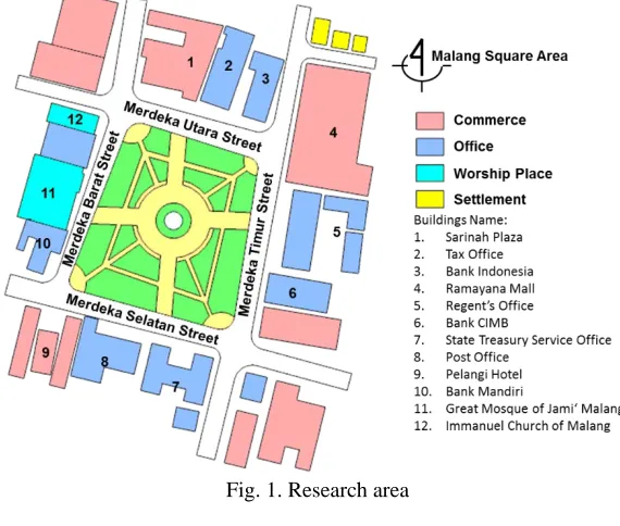
The area of Malang City Square is the center of Malang City itself which consists of four street corridors. The four corridors are Merdeka Utara street corridor, Jalan Merdeka Timur street corridor, Merdeka Selatan street corridor, and Merdeka Barat street corridor. Each corridor in the area can be seen in Figure 1. The corridors in Malang City Square must have a visual display that represents the image of the area as the center of Malang City. This is so that people walking in the corridor can observe and recognize the area through the visual appearance of the corridor. Through this paper, researchers want to identify the legibility of each corridor in Malang City Square, in designing a representation of the neighborhood of the square as the center of Malang City that is easily recognizable by local residents and immigrants.
Fig. 1. Research area
II. RESEARCHELABORATION
In this research will use descriptive-qualitative research based on walkthrough analysis. This analysis can help to assessment of urban quality by walking through the area with observation and seeing the impression that is felt along the way through the existing picture/photo recording of the location [6]. The data collected by direct site-observation, taking photograph of the travel sequence in the area of Malang City Square. This research will try to identify the legibility of the area in the form of visual quality in designing the image of Malang City Square. So that the data obtained the visual quality of the area that is easily recognized by people or less prominent.
III. RESULT
A. Merdeka Utara Street Corridor
Fig. 2. Serial vision of Merdeka Utara street corridor
First, public and private space. According to Figure 2which shows the description of the travel sequence, there is a clear boundary between public and private space which formed by the fence of buildings along the corridor. Visually, the height of the fence does not obstruct the frontage view of the building itself, but the presence of vegetation along the corridor makes the view towards the building becomes slightly obstructed.
Second, landmark and environmental features. The appearance of buildings visually blocked by vegetation along the corridor, so that in this corridor is not found a building that has the potential as a landmark. Meanwhile in terms of environmental features, this corridor is easier to recognize as the area of Malang City Square with the existence of a large row of trees on the right side or side of the square itself.
B. Merdeka Timur Street Corridor
Fig. 3. Serial vision of Merdeka Timur street corridor
First, public and private space. In the description of the travel sequence at Figure 3, there is a clear boundary between public and private space which formed by the fence of buildings along the corridor. Visually, the height of the fence does not obstruct the frontage view of the building itself, but the presence of vegetation along the corridor makes the view towards the building becomes slightly obstructed.
[image:3.612.126.477.417.638.2]of the corridor caused by vegetation blocking, the sequel is easily recognizable in terms of façade appearance and altitude, precisely on the numbers 3 and 4 at Figure 3. In addition, this building also stimulates views with contrast in the form and dimensions in the environment.
[image:4.612.219.392.90.189.2]Fig. 4. The building of Bank CIMB in Merdeka Timur street corridor is potentially to be a corridor landmark
Fig. 5. The contrast of Bank CIMB building is obtained from the height of the building and the façade that is different from the surrounding building
In terms of place, the Bank CIMB building has a height of 3 floors with a low border distance from the street, giving the impression of a monumental and a modern touch. While in terms of content, this building has the potential to increase the legibility of Merdeka Timur street corridor as a landmark with the typology of modern buildings and different altitudes with other buildings. In addition, the use of building facades in the form of glass covering the entire building of Bank CIMB also add contrast to the appearance of buildings with buildings around it.
[image:4.612.97.481.409.628.2]C. Merdeka Selatan Street Corridor
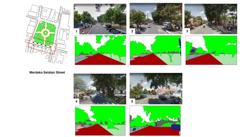
Fig. 6. Serial vision of Merdeka Selatan street corridor
First, public and private space. According to Figure 6which shows the description of the travel sequence, there is a clear boundary between public and private space which formed by the fence of buildings along the corridor. Visually, the height of the fence does not obstruct the frontage view of the building itself, but the presence of vegetation along the corridor makes the view towards the building becomes slightly obstructed.
corridor is easier to recognize as the area of Malang City Square with the existence of a large row of trees on the right side or side of the square itself.
[image:5.612.118.480.98.319.2]D. Merdeka Barat Street Corridor
Fig. 7. Serial vision of Merdeka Barat street corridor
First, public and private space. In the description of the travel sequence at Figure 7, there is a clear boundary between public and private space which formed by the fence of buildings along the corridor. Visually, the height of the fence does not obstruct the frontage view of the building itself, but the presence of vegetation along the corridor makes the view towards the building becomes slightly obstructed.
Second, landmark and environmental features. From the analysis, there is a building that has potential as a landmark on this corridor in terms of the height of the building and the shape of the domed roof used by the building. The building is Masjid Jami' that can be easily observed and recognized from the beginning of the corridor. This building provides a unique image since the beginning of the corridor on the serial vision with the roof shape of the tower used. So as to stimulate the view with contrast in the form of a roof that is different from the surrounding environment.
Fig. 8. The building of Masjid Jami’ in Merdeka Barat street corridor is potentially to be a corridor landmark
Fig. 9. The contrast of the building of Masjid Jami’ obtained from roof shape unlike the building surrounding
IV. CONCLUSION
In terms of public and private space area of Malang City Square, there is the use of grating and hedges that provide clarity of boundaries between public and private space so that people know the boundaries of their space to walk. The use of a low fence and not blocking the frontage view of the building will also give the impression of an attractive walk for pedestrians. so people will enjoy the walking activity as well as other activities with the building frontage generated by the area.
While in terms of landmark and environmental features, there are buildings that have potential as a landmark of the area, which is the building of Masjid Jami'. This building has a massive shape and the use of different types of dome roof with buildings around it. In addition, there are also other buildings that have potential as a landmark in the corridor. The building is Bank CIMB that has a height and facade of the building in contrast with the surrounding buildings. The existence of landmark potential landmarks in the area of Malang City Square, can facilitate people in recognizing the area and determine the direction of their destination within the area. From the above identification can be concluded that the need for arrangement in order to improve the legibility of the corridor to strengthen the image of Malang City Square area. The arrangement is related to the vegetation arrangement along the corridor blocking the frontage of the building so that the appearance of the building can be easily observed. Then the buildings that have the potential to become landmarks need to be highlighted so that its existence is easier to be recognized as the area of Malang City Square.
ACKNOWLEDGEMENT
This publication based on Master Program Thesis which conducted in 2018, entitled Designing Malang City Square based on Pedestrian-Friendly Concept.
REFERENCES [1] K. Lynch, The Image of The City. Cambridge, Massachusetts: M.I.T. Press, 1960. [2] R. Krier, Urban Space. New York: Rizzoli International Publications, 1979.
[3] F. Janches, Significance of Public Space In The Fragmented City: Designing Strategies For Urban Opportunities In Informal Settlements Of Buenos Aires City. UNU-WIDER, World institute for Development Economics research,Vol, 13, 2011.
[4] E.T. Sunarti, M. Arief Al Husaini, and A. Tribhuwaneswari. Adaptation of The Public Space to The Challenge of Limited Indoor Space by The Immigrant: A Case of Informal Settlement around The Railway Terrace, Surabaya, Indonesia. Global Journal of Engineering Science and Research Management (GJESRM) Vol. 3 No.10 October 2016 p.21-29, 2016.
[5] E. Burton, and L. Mitchell, Inclusive Urban Design - Street for Life. Oxford: Architectural Press, 2006. [6] G. Cullen, The Concise Townscape. London: Architectural Press, 1961.
[7] Urban Design Toolkit, Third Edition, 2006. Ministry for the Environment, Wellington, New Zealand.
AUTHORS
First Author – Ryski Dwi Pratowo, Post Graduate Student, Department of Architecture Faculty of Architecture, Design and Planning, Sepuluh Nopember Institute of Technology (ITS), Surabaya 60111, INDONESIA, [email protected]
Second Author – Endang Titi Sunarti, Lecturer, Department of Architecture Faculty of Architecture, Design and Planning, Sepuluh Nopember Institute of Technology (ITS), Surabaya 60111, INDONESIA, [email protected].
Third Author – Purwanita Setijanti, Lecturer, Department of Architecture Faculty of Architecture, Design and Planning, Sepuluh Nopember Institute of Technology (ITS), Surabaya 60111, INDONESIA, [email protected].