http://dx.doi.org/10.4236/pos.2015.63004
Multiple Ambiguity Datum Precise Point
Positioning Technique Using
Multi-Constellation GNSS: GPS,
GLONASS, Galileo and BeiDou
Mahmoud Abd Rabbou
Department of Civil Engineering, Ryerson University, Toronto, Canada Email: [email protected]
Received 5 May 2015; accepted 14 July 2015; published 20 July 2015
Copyright © 2015 by author and Scientific Research Publishing Inc.
This work is licensed under the Creative Commons Attribution International License (CC BY). http://creativecommons.org/licenses/by/4.0/
Abstract
products and the mathematical correlation between the positioning and ambiguity parameters.
Keywords
GNSS, PPP, GPS, GLONASS, Galileo, BeiDou, BSSD, Multiple Ambiguity Datum
1. Introduction
Precise Point Positioning has been studied by a number of research groups in the last two decades (e.g. [1] and
[2]). To speed up the PPP solution convergence time, a number of PPP ambiguity resolution techniques have been developed [3]-[5]. PPP has been used in a number of applications, including precise surveying, disaster monitoring, offshore exploration, and others [6]-[8]. Commonly, in precise point positioning (PPP), the un-dif- ferenced ionosphere free linear combination of GPS and GLONASS code and phase measurements are used to cancel out the first order ionospheric effect [9]-[11]. The satellite orbits and clock errors can be accounted for using IGS precise orbital and clock products. The GPS/GLONASS inter-system bias can be considered as addi-tional unknown in addition to the receiver clock bias. The tropospheric error component can be modeled suffi-ciently by using number of empirical models such as Saastamoinen and Hopfield models or can be accounted for by using regional tropospheric correction models such as the NOAATrop model [12]. The effects of ocean loading, earth tide, carrier-phase windup, sagnac, relativity, and satellite antenna phase-centre variations can be rigorously modeled [13]. However, the major drawback of the standard technique is the long convergence time to reach to centimeter positioning accuracy due to the satellite geometry in addition to the improper modeling of errors and biases, such as the satellite and receiver code biases. The satellite geometry can be enhanced by add-ing the newly constellation satellites system namely the European navigation satellite system (Galileo) and the Chinese navigation satellite system (BeiDou). The additional observations can enhance the satellite geometry and reduce the convergence time of the PPP [11] [14] [15].
On the other hand, the satellite code bias is lumped to the phase ambiguity parameters and as one receiver clock unknown is used in both code and phase measurements, the receiver code bias is also absorbed by the am-biguity parameters. To completely cancel out the receiver related biases from both code and phase GNSS ob-servations, between-satellite-single-difference (BSSD) ionosphere-free PPP technique can be used [16]. In GNSS constellations level, multiple GNSS satellites are used as references. However, in BSSD technique, the satellite differential code biases are still affecting the phase ambiguities due to the dissimilarities of satellites code biases which are produced from the signals spectrum dissimilarities in the filtering and correlation proc-esses [17]. One of the major drawbacks of this technique is minimum two satellites should be available in each GNSS system which is still not guaranteed especially for Galileo and BeiDou systems.
2. GNSS Observations Equations
The general ionosphere-free equations for pseudorange and carrier-phase can be written as ([19] and [20])
(
)
(
)
2 2
1 2
1 1 2 2
3 2 2 1 2
1 2
s s s
r r r
f P f P
P cdt cdt T c Ad Bd c Ad Bd e
f f ρ
−
= = + − + − − + − +
− (1)
(
)
(
)
( )
2 2
1 2
1 1 2 2
3 2 2 1 2
1 2
s s s
r r r
f f
cdt cdt T c A B c A B N
f f ρ δ δ δ δ λ ε
Φ − Φ
Φ = = + − + + − − − + +
− (2)
where P1 and P2 are GNSS pseudorange measurements on L1 and L2, respectively; Φ1 and Φ2 are the GNSS carrier phase measurements on L1 and L2, respectively; dtr and s
dt are the clock errors for receiver and satellite, respectively; dr and ds are frequency-dependent code hardware delay for receiver and satellite, respectively; δr and δs are frequency-dependent carrier phase hardware delay for receiver and satellite,
re-spectively; e, ε are relevant system noise and un-modeled residual errors; and λN is the ambiguity term for phase measurements. For the un-differenced ionosphere free linear combination, this term is not integer due to
the non-integer nature of the combination coefficients,
2 2
1 1 1 2 2 2
2 2
1 2
f N f N
N
f f
λ λ
λ = −
− , where N1 and N2 are the
1
L and L2 non-integer ambiguity parameters, including the initial phase biases at the satellite and the receiver, respectively;λ1?and λ2 are the wavelengths of the L1 and L2 carrier frequencies, respectively; c is the speed of light in vacuum; T is the tropospheric delay component; ρ is the true geometric range from the antenna phase center of the receiver at reception time to the antenna phase center of the satellite at transmission time. A
and B are frequency dependent factors
2 1 2 2 1 2 f A f f =
− and
2 2 2 2 1 2 f B f f = − .
2.1. Standard Un-Differenced GNSS PPP Technique
Using Equations (1) and (2) and considering GPS time as a reference time system, the un-differenced ionos-phere-free linear combinations of GPS, GLONASS, Galileo and BeiDou observations can be written as [11]
3
r s s
G G r G G G G G
P =ρ +c dt +B −c dt −B +T +e (3)
[
]
3 [ ]
r s s
E E r G E E E E E
P =ρ +c dt +B −c dt −B +T +c ISB +e (4)
[
]
3
r s s
R R r G R R R R R
P =ρ +c dt +B −c dt −B +T +c ISB +e (5)
[
]
3
r s s
C C r G C C C C C
P =ρ +c dt +B −c dt −B +T +c ISB +e (6)
(
)
3 G
r s s r s
G G r G G G G
G
c dt B c dt B T N B B
ρ
λ
ε
Φ = + + − − + + + ∆ − ∆ + (7)
[
]
(
)
3
r s s r s
E
ρ
Ec dt
rB
G
c d
EB
E
T
Ec ISB
Eλ
N
B
B
Eε
EΦ =
+
+
−
−
+
+
+
+ ∆ − ∆
+
(8)[
]
(
)
3
r s s r s
R R r G R R R R R
R
c dt
B
c dt
B
T
c ISB
N
B
B
ρ
λ
ε
Φ =
+
+
−
−
+
+
+
+ ∆ − ∆
+
(9)[
]
(
)
3
r s s r s
C C r G C C C C C
C
c dt B c dt B T c ISB N B B
ρ
λ
ε
Φ = + + − − + + + + ∆ − ∆ + (10)
where G, R, E and C refer to GPS, GLONASS, Galileo and BeiDou systems observations, respectively; ISB is the inter-system bias;
B
r,B
s are ionosphere-free differential code biases for receiver and satellites, respec-tively;∆
B
r is the difference between receiver differential code and phase biases;∆
B
s is the difference be-tween satellite differential code and phase biases. As can be seen from Equations (7) to (10), the un-calibrated biases such as∆
B
r and∆
B
s are lumped with the ambiguity parameters. Table 1 shows the mathematical eq-uations for the different GNSS biases.2.2. Between Satellites Single Difference GNSS PPP Technique
Table 1. Different GNSS biases.
[ ] 1 2
1 2 ;
r s s s
G r r G G G
B = Ad −Bd B =Ad −Bd
[ ] 1 2
1 2 ;
r s s s
R r r R R R
B = Ad −Bd B =Ad −Bd
[ ] 1 2
1 2 ;
r s s s
E r r E E E
B = Ad −Bd B =Ad −Bd
[ ] 1 2
1 2 ;
r s s s
C r r C C C
B = Ad −Bd B =Ad −Bd
(
)
;(
)
r r r s s s
P P
B c BΦ B B c BΦ B
∆ = − ∆ = −
; ;
r r r r r r
E E G R R G C C G
ISB =B −B ISB =B −B ISB =B −B
satellite-single-difference (BSSD) ionosphere-free PPP technique can be used for combined GNSS observations model. For each system, a reference satellite is selected while the other GNSS satellites observations are sub-tracted from it. To develop the mathematical equations of BSSD technique, four GNSS satellites are selected mainly GPS l, GLONASS m, Galileo n and BeiDou o,to be reference satellites to the four constellation systems observations. Following [11], GNSS-BSSD model can be written as.
(
) (
)
3 3
l
l l s s s s l l
G G G G G G G G G G G G
P −P =
ρ
−ρ
−c dt +B − dt −B +T −T +e −e (11)
(
) (
)
3 3
m
m m s s s s m m
E E E E E E E E E E E E
P −P =
ρ
−ρ
−c dt −B − dt −B +T −T +e −e (12)
(
) (
)
3 3
n
n n s s s s n n
R R R R R R R R R R R R
P −P =
ρ
−ρ
−c dt −B − dt −B +T −T +e −e (13)
(
) (
)
3
o
o o s s s s O o
C C C C C C C C C C C C
P −P =
ρ
−ρ
−c dt −B − dt −B +T −T +e −e (14)
(
) (
)
(
) (
)
3 3
l l
l l s s s s l s s l
G G ρG ρG c dtG BG dtG BG TG TG λN B λN B εG εG
Φ − Φ = − − − − − + − + − ∆ − − ∆ + −
(15)
(
) (
)
(
) (
)
3 3
m m
m m s s s s m s s m
E E E E E E E E E E E E
E E
c dt B dt B T T N B N B
ρ ρ λ λ ε ε
Φ − Φ = − − − − − + − + − ∆ − − ∆ + −
(16)
(
) (
)
(
) (
)
3
n n
n n s s s s n s s n
R R R R R R R R R R R R
R R
c dt B dt B T T N B N B
ρ ρ λ λ ε ε
Φ − Φ = − − − − − + − + − ∆ − − ∆ + −
(17)
(
) (
)
(
) (
)
3
o o
o o s s s s o s s o
C C C C C C C C C C C C
C C
c dt B dt B T T N B N B
ρ
ρ
λ
λ
ε
ε
Φ − Φ = − − − − − + − + − ∆ − − ∆ + −
(18)
As can be seen from Equations (19) to (26) that the receiver related code and phase biases, receiver clocks and inter-system biases are completely removed. However, the mathematical correlation between the observa-tions should be taken into account when forming the observation weighted matrix for this model [16].
2.3. Multiple Ambiguity Datum (MAD) GNSS PPP Technique
pa-rameter of the selected GPS reference satellite leading to code biases free. Also the phase inter-system biases
ISPB will be lumped by the differences between the ambiguities of the GPS reference satellite and the other GNSS reference satellites and it will be also code biases free. The mathematical model for MAD PPP technique can be written as follows.
3
p s
G G r Gp G G
P =ρ +c dt −c dt +T +e (19)
[
]
3
p s
E E r Ep E E E
P =ρ +c dt −c dt +T +c ISCB +e (20)
[
]
3
p s
R R r Rp R R R
P =ρ +c dt −c dt +T +c ISCB +e (21)
[
]
3
p s
C C r Cp C C C
P =ρ +c dt −c dt +T +c ISCB +e (22)
( )
11 1 1
3G G cdtr N G c dtG TG G
φ
φ
ρ λ ε
Φ = + + − + +
(23)
( )
1( ) ( )
2 12 2 2 2
3G G cdtr N G c dtG T G N G N G G
φ
φ
ρ λ λ λ ε
Φ = + + − + + − +
(24)
( )
1(
)
( ) ( )
1 11 1
3
s
E E r E E E E
G E G
cdtφ N c dt φ T c ISPB N N
ρ λ λ λ ε
Φ = + + − + + + − +
(25)
( )
1(
)
( ) ( )
1 1(
( ) ( )
2 1)
2 2 2 2
3E E r E E E E
G E G E E
cdtφ N c dt φ T c ISPB N N N N
ρ λ λ λ λ λ ε
Φ = + + − + + + − + − +
(26)
( )
1(
)
( ) ( )
1 11 1 1
3R R r R R R R
G R G
cdtφ N c dt φ T c ISPB N N
ρ λ λ λ ε
Φ = + + − + + + − +
(27)
( )
1(
)
( ) ( )
1 1(
( ) ( )
2 1)
2 2 2 2
3R R r R R R R
G R G R R
cdtφ N c dt φ T c c ISPB N N N N
ρ λ λ λ λ λ ε
Φ = + + − + + + − + − +
(28)
( )
1(
)
( ) ( )
1 11 1 1
3C C r C C C C
G C G
cdtφ N c dt φ T c ISPB N N
ρ λ λ λ ε
Φ = + + − + + + − +
(29)
( )
1(
)
( ) ( )
1 1(
( ) ( )
2 1)
2 2 2 2
3C C r C C C C
G C G C C
cdtφ N c dt φ T c ISPB N N N N
ρ λ λ λ λ λ ε
Φ = + + − + + + − + − +
(30)
where p r
dt and dtr− are the code and phase receiver clocks respectively, dtJps and s J
dt− are the code and
phase satellite clocks respectively, ISPB and ISCB are the code and phaseinter-system biases respectively, 1 and 2 refers to the satellite number from each GNSS system. The new phase receiver clock unknown will be
(
1)
G r
dt +
λ
N which in role makes the ambiguities for the remaining GPS satellite phase observations are thedifference between the GPS satellite ambiguity λNiG and the GPS reference satellite ambiguity 1 G N λ ,
i i 1
G G G
N N N
λ
=λ
−λ
. As can been seen, only one phase receiver clock unknown is considered for all GNSS con-stellations, as a result, for other GNSS observations the GPS reference satellite ambiguity λN1G will be combined with the phase inter-system bias ISPB. To avoid system singularity, other ambiguity-datum is needed for each system. For each system, the ambiguity of the GNSS reference satellite will be combined with the ISPB as a result the phase inter-system bias for a GNSS system will be shifted by the difference between the
GPS and the GNSS system reference satellites, c ISPB =c IS
[
PB]
+λN1J−λN1G. The ambiguities for there-maining GNSS satellites will be the difference between the GNSS satellite ambiguity
λ
Nij and the GNSSref-erence satellite ambiguity
λ
N1j where j refers to the GNSS system, 1
i i
J J J
N N N
λ
=λ
−λ
.3. Current limitations of GNSS PPP Techniques
Based on the mathematical equations presented in the traditional un-differenced PPP technique, it can be noticed that there is a coupling between the positioning parameters in the code and phase measurements due to the un-derdetermined nature of the phase observations. In other words, as we cannot estimate the positioning parame-ters from the phase measurements only due to the existence of the ambiguity parameparame-ters, the code measurements are needed to aid in estimating the positioning parameters till reaching to correct resolved ambiguity parameters. Up till reaching to correct ambiguity parameters with continuous decreasing of the ambiguity uncertainty (re-ducing ambiguity variances with time), the estimation filter is converting with time to estimate precise position-ing parameters from the precise phase measurements. Durposition-ing this period, which is called as the convergence time, the receiver and satellite code biases and their stochastic nature highly contribute on the estimated posi-tioning parameters. Due to the mathematical correlation between the ambiguities and the posiposi-tioning parameters, the ambiguities are highly affected by these code biases in addition to the phase biases as can be seen in Equa-tions (7) to (10). Combining code and phase biases to the ambiguities is leading to increasing the time to reach to correct resolved ambiguity parameters.
To enhance the convergence time of the current PPP positioning solution which as mentioned above is highly affected by the quality of the code observations, the code measurements should be improved by eliminating or modeling the receiver and satellite code biases. The receiver code and phase biases can be completely eliminated by applying BSSD technique as can be seen in Equations (11) to (18). Theoretically, both the un-differenced and BSSD techniques are statistically identical, assuming that the stochastic characteristics of the time-varying na-ture of the receiver code biases are modelled perfectly or the receiver code bias and the positioning parameters are mathematically uncorrelated. Due to the imperfection of the stochastic modelling of the receiver biases, its time-varying nature is affecting the positioning parameters (and the ambiguities) which is leading to a poorer precision solution (longer convergence time) for the un-differenced technique than the BSSD solution. However, the enhancement in convergence time of the BSSD is limited due to the time-varying nature of the satellite code biases. In addition, the differencing process applied to the GNSS observations will increase the noise ration of the difference observations. As the satellite code biases cannot be eliminated similar to the receiver code biases, it should be modeled or combined to the satellite clock corrections.
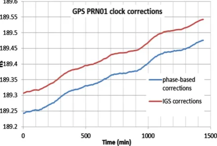
[image:6.595.204.424.547.695.2]The IGS and MGEX-IGS clock products are already combined with the satellite code biases. However, these products are only combined with constant satellite code biases due to the combined code-phase measurement es-timation and the smoothing process applied.Figure 1 shows a comparison between the phase-based clock cor-rections obtained from Natural Resources Canada (NRCan), and the IGS clock corcor-rections for August 3, 2008. It can be noticed that the IGS clock correction is phase-based smooth clock version. As a result, the current IGS clock products cannot simulate the time-varying satellite code biases affect the pseudorange measurements in the user model. To overcome this limitation, satellite code based clock corrections combined with time-varying satellite code biases should be estimated and used as a satellite clock corrections dtJps for only the pseudorange measurements in the MAD PPP technique. On the other hand, to preserve the integrity nature of the ambiguity
parameters, phase based satellite clock corrections s J
dt− should be estimated and employed as a satellite clock correction for the phase measurements only. Similar to the traditional IGS clock products, the phase based clock corrections will be combined with a constant bias which is the ambiguity of the reference satellite used in the network analysis. However, in contrast to the IGS clock products, this bias can be kept to be integer value (com-bination of integer values on L1 and L2) to preserve the integrity nature of the ambiguity parameters for the used model (Collins et al. 2010).
Based on the discussion above, combining the BSSD technique which removes the receiver code biases with multiple ambiguity datum considering code, and phase based clock corrections will significantly reduce the convergence time and enhance the ambiguity resolution. However, currently, these clock products are not avail-able for the GNSS constellations. As the traditional IGS MGEX clock products are employed in MAD technique, the code observations used in both the standard technique and the MAD technique will be statistically the same. As a result, the convergence time in both techniques should be comparable. In contrast, at present, the BSSD technique may provide shorter convergence time compared with the un-differenced and MAD techniques based on the balance between the eliminations of the time-varying receiver code biases and the higher noise ration ex-pected of the difference observations. Due to the lack of phase and code based products, currently combining the MAD and BSSD techniques will not present also shorter convergence time. To clarify the theoretical mathe-matical models introduced in this research analytically, a comparison between the three PPP techniques is pre-sented in the next section.
4. Analysis and Results
To investigate the contribution of the newly GNSS observations, GNSS data from four IGS MGEX stations are processed namely, CUT0, BRST, DLF1 and UNB at DOY 305, 2013. The input data are the un-differenced first- order ionosphere-free linear combination of GNSS code and carrier-phase measurements. The IGS MGEX precise orbit and clock products are employed to account for orbital and clock errors [21]. Tropospheric errors are accounted for using the UNB3 model [22]. All remaining errors, including carrier-phase windup, relativity, Sagnac, earth tides, and ocean loading are corrected for with sufficient accuracy by using existing models [13].
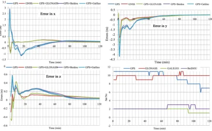
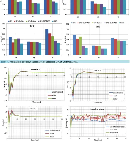
Figure 2 andFigure 3 show the positioning error results and the GNSS satellite availability for CUT0 and UNB stations, respectively, as examples. As can be seen that compared with the existence combined GPS/ GLONASS PPP positioning solution, the additional Galileo and BeiDou observations have a marginal effect on the positioning accuracy and convergence time. The insignificant effect is due to the sufficient number of GNSS satellite observations originally available from both GPS and GLONASS. To assess the contribution of the new GNSS observations compared to the GPS PPP positioning accuracy, both GPS/Galileo and GPS/BeiDou are shown in comparison with the GPS only PPP. Due to the limited number of Galileo satellites, the contribution of Galileo observations can be considered insignificant on enhancing the GPS PPP positioning accuracy and con-vergence time. However, the contribution of BeiDou observations can be considered significant in some station such as CUT0 when sufficient number of satellites is available in contrast with the UNB station with maximum three BeiDou satellites available. As a result, the contribution of BeiDou can be considered geographically de-pendent. Figure 4 summarizes the positioning accuracy after two hours of GNSS observation processing for the different GNSS combinations. It can be noticed that two to four centimeters enhancement in multi-constellation GNSS positioning accuracy is detected compared with the GPS positioning accuracy.
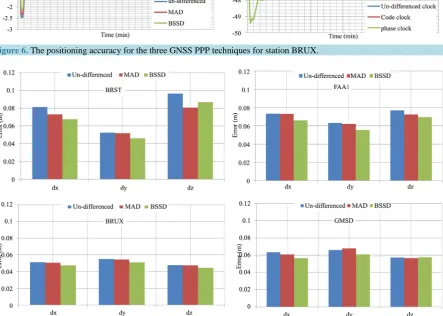
To test the developed GNSS PPP techniques, namely the standard un-differenced, multiple ambiguity datum (MAD) and BSSD ionosphere-free techniques, further GNSS data from four MGEX IGS stations are processed namely BRST, BRUX, FAA1 and GMSD at DOY 1, 2014. Figure 5 andFigure 6 show the positioning accu-racy with time and a comparison among the un-differenced, code and phase receiver clock estimation biases for stations BRST and BRUX, respectively, as examples.
Figure 2. The positioning accuracy for different GNSS combinations for station CUT0 with the available GNSS satellites.
Figure 3. The positioning accuracy for different GNSS combinations for station UNB with the available GNSS satellites.
[image:8.595.94.533.362.633.2]Figure 4. Positioning accuracy summary for different GNSS combinations.
Figure 5. The positioning accuracy for the three GNSS PPP techniques for station BRST.
[image:9.595.90.540.156.649.2]Figure 6. The positioning accuracy for the three GNSS PPP techniques for station BRUX.
Figure 7. Positioning accuracy summary of the different GNSS PPP techniques.
5. Conclusion
[image:10.595.93.537.305.621.2]model cancelled out the receiver related biases and errors from both GNSS code and phase measurements. The IGS MGEX clock and orbital products were used to correct for the satellite clock and orbital errors. GNSS data produced from a number of MGEX stations was used to investigate the accuracy and convergence time for the different PPP techniques. Also, the contribution of the additional Galileo and BeiDou systems observations on the traditional GPS/GLONASS PPP positioning accuracy and convergence time was investigated. The results showed that the contribution of Galileo observations could be considered marginal on enhancing both the GPS and GPS/GLONASS PPP positioning accuracy and convergence time due to the limited Galileo observations. However, the contribution of BeiDou observations can be considered geographically dependent based on the BeiDou satellite availability in each station. The multiple ambiguity datum (MAD) GNSS PPP technique pre-sented comparable convergence time compared with the standard un-differenced technique due to the lack of code and phase-based satellite clock products and the mathematical correlation between the positioning and clock-ambiguity parameters. However, the BSSD model was slightly improved the convergence time compared with other techniques. Moreover, the three GNSS PPP techniques showed comparable positioning accuracy after one hour of GNSS observations processing.
References
[1] Kouba, J. and Héroux, P. (2001) Precise Point Positioning Using IGS Orbit and Clock Products. GPS Solutions, 5, 12- 28. http://dx.doi.org/10.1007/PL00012883
[2] Gao, Y. and Chen, K.Z. (2004) Performance Analysis of Precise Point Positioning Using Real-Time Orbit and Clock Products. Journal of Global Positioning Systems, 3, 95-100. http://dx.doi.org/10.5081/jgps.3.1.95
[3] Collins, P., Bisnath, S., Lahaye, F. and Heroux, P. (2010) Undifferenced GPS Ambiguity Resolution Using the De-coupled Clock Model and Ambiguity Datum Fixing. Navigation, 57, 123-135.
http://dx.doi.org/10.1002/j.2161-4296.2010.tb01772.x
[4] Ge, M., Gendt, G., Rothacher, M., Shi, C. and Liu, J. (2008) Resolution of GPS Carrier-Phase Ambiguities in Precise Point Positioning (PPP) with Daily Observations. Journal of Geodesy, 82, 389-399.
http://dx.doi.org/10.1007/s00190-007-0187-4
[5] Geng, J., Shi, C., Ge, M., Dodson, A.H., Lou, Y., Zhao, Q. and Liu, J. (2012) Improving the Estimation of Fractional- Cycle Biases for Ambiguity Resolution in Precise Point Positioning. Journal of Geodesy, 86, 579-589.
http://dx.doi.org/10.1007/s00190-011-0537-0
[6] Geng, J.H., Bock, Y., Melgar, D., Crowell, B.W. and Haase, J.S. (2013) A New Seismogeodetic Approach Applied to GPS and Accelerometer Observations of the 2012 Brawley Seismic Swarm: Implications for Earthquake Early Warn-ing. Geochemistry, Geophysics, Geosystems, 14, 2124-2142. http://dx.doi.org/10.1002/ggge.20144
[7] Rabbou, M.A. and El-Rabbany, A. (2015) Integration of GPS Precise Point Positioning and MEMS-Based INS Using Unscented Particle Filter. Sensors, 15, 7228-7245. http://dx.doi.org/10.3390/s150407228
[8] Xu, P.L., Shi, C., Fang, R.X., Liu, J.N., Niu, X.J., Zhang, Q. and Yanagidani, T. (2013) High-Rate Precise Point Posi-tioning (PPP) to Measure Seismic Wave Motions: An Experimental Comparison of GPS PPP with Inertial Measure-ment Units. Journal of Geodesy, 87, 361-372. http://dx.doi.org/10.1007/s00190-012-0606-z
[9] Cai, C.S. and Gao, Y. (2007) Precise Point Positioning Using Combined GPS and GLONASS Observations. Journal of Global Positioning Systems, 16, 13-22. http://dx.doi.org/10.5081/jgps.6.1.13
[10] Abd Rabbou, M. and El-Rabbany, A. (2015) PPP Accuracy Enhancement Using GPS/GLONASS Observations in Ki-nematic Mode. Positioning, 6, 1-6. http://dx.doi.org/10.4236/pos.2015.61001
[11] Rabbou, M.A. and El-Rabbany, A. (2015) Precise Point Positioning Using Multi-Constellation GNSS Observations for Kinematic Applications. Journal of Applied Geodesy, 9, 15-26. http://dx.doi.org/10.1515/jag-2014-0021
[12] Gutman, S., Fuller-Rowell, T. and Robinson, D. (2003) Using NOAA Atmospheric Models to Improve Ionospheric and Tropospheric Corrections. Proceedings of theUS Coast Guard DGPS Symposium, Portsmouth, 17-19 June 2003. [13] Kouba, J. (2009) A Guide to Using International GNSS Service (IGS) Products. International GNSS.
[14] Cai, C., Gao, Y., Pan, L. and Zhu, J. (2015) Precise Point Positioning with Quad-Constellations: GPS, BeiDou, GLONASS and Galileo. Advances in Space Research, 56, 133-143. http://dx.doi.org/10.1016/j.asr.2015.04.001
[15] Li, X., Zhang, X., Ren, X., Fritsche, M., Wickert, J. and Schuh, H. (2015) Precise Positioning with Current Multi- Constellation Global Navigation Satellite Systems: GPS, GLONASS, Galileo and BeiDou. Scientific Reports, 5, 8328.
http://dx.doi.org/10.1038/srep08328
[17] Phelts, R.E. (2007) Range Biases on Modernized GNSS Codes. Proceedings of the European Navigation Conference GNSS/TimeNav, Geneva, 29 May-1 June 2007. http://waas.stanford.edu/~wwu/papers/gps/PDF/PheltsENC07.pdf
[18] Shi, J.B. and Gao, Y. (2014) A Comparison of Three PPP Integer Ambiguity Resolution Methods. GPS Solutions, 18, 519-528.
[19] Hofmann-Wellenhof, B., Lichtenegger, H. and Walse, E. (2008) GNSS Global Navigation Satellite Systems: GPS, GLONASS, Galileo, and More. Springer, New York.
[20] Leick, A. (2004) GPS Satellite Surveying. 3rd Edition, Wiley, New York.
[21] Montenbruck, O., Steigenberger, P., Khachikyan, R., Weber, G., Langley, R.B., Mervart, L. and Hugentobler, U. (2014) IGS-MGEX: Preparing the Ground for Multi-Constellation GNSS Science. Inside GNSS, 9, 42-49.