1
Using Water-Sensitive Urban Design to
improve drainage capacity
Examination of the impact of distributed and catchment scale Water -Sensitive Urban Design systems on flow frequency
Bachelor Thesis
Executed May – August 2014Course name: Bachelor Eindopdracht Course ID: 192284108
2
Abstract
Commissioned by the Centre for Water Management and Reuse, located in Adelaide, South Australia, this research was carried out to examine the impact of distributed and catchment scale Water-Sensitive Urban Design systems on runoff flow frequency.
Currently, Greater Adelaide’s water supply for drinking and non-drinking purposes falls short of the demand. This shortfall will only increase in the future due to rising demand and diminishing resources if the South Australian Government does not undertake action. Also, the ratio of infill to fringe development for new housing will shift to a more infill-orientated ratio in Adelaide. This increased dwelling intensity poses challenges to infrastructure in the existing urban environment of the Greater Adelaide region. Amongst other things, this means that metropolitan catchment areas where infill development takes place will be likely to experience changes in stormwater runoff flow regimes. One of those areas is the Frederick Street catchment, a 44.7-Ha urban catchment which is the study area of this report. Building a new drainage system for the entire catchment is an expensive and time-consuming solution which will also cause a lot of nuisance. This is why alternative approaches are being taken into consideration. Water Sensitive Urban Design seems a promising solution to the problem. Therefore, it has to be investigated if Water-Sensitive Urban Design can be applied in the catchment area in order to reduce the effects caused by infill development on flow frequency. The research can contribute to the understanding of the impact of infill development on a medium sized urban catchment. It is important to understand the impact of infill development and how to overcome these impacts with WSUD tools. This might lead to sustainable solutions which do not involve drastic and costly adjustments to urban drainage systems.
The objective of the project is to determine suitable WSUD measures for the catchment by producing an updated version of the catchment model using flow data being collected since August 2013. The existing model was updated and then calibrated. When the model was calibrated, the use of several suitable WSUD measures were simulated on the catchment to view their effect on flow frequency. The results of the simulation show that the total volume of runoff increases by 12% (and an average increase of 11% in peak flows) if no action is undertaken. The use of rainwater tanks and/or bioretention systems within the catchment can be effective to maintain the current flow levels, or even decrease the runoff flows and volumes.
It was found that Water-Sensitive Urban Design can be used to preserve the existing flow regimes of the Frederick Street catchment. For street scale WSUD measures, rainwater tanks and bioretention systems are showing promising simulation results for reducing runoff volumes and peak flows. The most effective way of reducing runoff volumes seems to be the installation of rainwater tanks. Peak flow reduction on the other hand can be achieved by both rainwater tanks and bioretention basins. Although bioretention basins achieve a higher overall reduction of peak flows, it should be noted that for very extreme storm events they are not capable of significant peak flow reduction.
3
Foreword
This report is the outcome of my internship at the Centre for Water Management & Reuse at the University of South Australia. The project was conducted as the final part of my Bachelor in Civil Engineering. It allowed me to apply my previous experience in the field of Civil Engineering on water-related issues at the Centre for Water Management & Reuse. Moreover, staying in Australia for three months proved to be an excellent opportunity to improve my communication skills in English.
4
Table of Contents
Abstract ... 2
Foreword ... 3
List of figures ... 5
List of tables ... 5
1 Introduction ... 6
1.1 Problem definition ... 6
1.1.1 Introduction ... 6
1.1.2 Water Management in South Australia ... 6
1.2 Research design ... 6
1.2.1 Centre for Water Management and Reuse (CWMR) ... 6
1.2.2 The study area ... 7
1.2.3 Research objective ... 8
1.3 Research questions... 8
1.4 Research methods ... 9
1.5 Importance of the research ... 9
2 Theoretical context ... 10
2.1 Water-Sensitive Urban Design (WSUD) ... 10
2.1.1 What is Water-Sensitive Urban Design? ... 10
2.1.2 Water-Sensitive Urban Design in practice ... 11
2.2 Software ... 12
2.2.1 Quantum Geographic Information System (QGIS) ... 12
2.2.2 Storm Water Management Model (SWMM) ... 12
2.2.3 Parameter estimation software (PEST 13.0) ... 12
3 Flow frequency analysis ... 13
3.1 Available data ... 13
3.2 Calibration of the model ... 13
3.3 Data validation ... 18
4 Analysis of WSUD effectiveness ... 19
4.1 Design of the analysis ... 19
4.2 Analysis of WSUD effectiveness on flow frequency ... 20
4.2.1 Rainwater tanks ... 20
4.2.2 Bioretention basins... 23
4.2.3 Peak flow reduction ... 24
4.3 Assessment of viability ... 25
5 Discussion ... 26
6 Conclusion ... 28
7 Recommendations... 29
8 References ... 30
Appendices ... 31
Appendix A: overview of common WSUD measures ... 32
Appendix B: preliminary investigation study area ... 34
Appendix C: Decision process flowchart ... 37
Appendix D: Simulated vs. Actual runoff ... 38
Appendix E: Antecedent rainfall vs. Volumetric runoff coefficient ... 44
Appendix F: Legislative requirements and approvals for rainwater tanks and bioretention basins 47 Appendix G: Peak flow simulation results using various WSUD measures ... 48
5
List of figures
Figure 1-1: The Frederick St. catchment ... 7
Figure 1-2: An example of housing development on Cliff street ... 8
Figure 2-1: The natural, urban and WSUD water balance ... 10
Figure 2-2: A rainwater tank ... 11
Figure 2-3: A bioretention basin ... 11
Figure 2-4: A visualisation of the subcatchments of the Frederick Street catchment in EPA SWMM .. 12
Figure 3-1: The location of the two gauges within the catchment ... 13
Figure 3-2: Representation of the catchment in QGIS ... 14
Figure 3-3: Visualisation of new roof area (shown in orange) per subcatchment ... 14
Figure 3-4: Coefficient of determination for the antecedent wetness ... 17
Figure 3-5: Antecedent rainfall vs. runoff coefficient for 12 (numbered) storm events ... 18
Figure 4-1: Volumetric runoff for several scenarios ... 20
Figure 4-2: 1 kL rainwater tank effectiveness ... 21
Figure 4-3: 2 kL rainwater tank effectiveness ... 21
Figure 4-4: 5 kL rainwater tank effectiveness ... 22
Figure 4-5: Proposed locations of the bioretention basins ... 23
Figure 4-6: Bioretention effectiveness ... 23
Figure 4-7: Predicted change in peak flows ... 24
Figure 4-8: Hydrograph showing the effect of the '5 kL rainwater tanks for all houses' scenario ... 25
Figure C-1: The WSUD selection process... 37
List of tables
Table 3-1: Summary of catchment properties for the Frederick Street catchment ... 14Table 3-2: The selected 12 storm events ... 15
Table 3-3: Predicted and recorded runoff coefficients for 12 selected events in 2013 and 2014 ... 16
Table 3-4: Key properties of the Frederick Street model ... 18
Table 4-1: Overview of characteristics for 1993, 2013 and 2040... 19
Table 4-2: Predicted change in catchment properties ... 19
Table 4-3: No WSUD prediction ... 20
Table 4-4: 1 kL rainwater tank simulation results ... 20
Table 4-5: 2 kL rainwater tank simulation results ... 21
Table 4-6: 5 kL rainwater tank simulation results ... 22
Table 4-7: Storage and underdrain properties ... 23
Table 4-8: Bioretention simulation results ... 23
6
1
Introduction
1.1
Problem definition
1.1.1
Introduction
South Australia is the driest state of the driest inhabited continent on earth. Adelaide, the capital city of South Australia, is the state capital with the least amount of annual rainfall (550 mm) per year. The CSIRO, Australia’s national science agency, believes South Australia may experience an overall decline in rainfall between 15 to 30% by 2050. The state is also experiencing population growth: the number of people living in South Australia (currently 1.65 million) will exceed 2 million by 2027. It is expected that the water demand will sharply rise, while the available water resources will decline. Currently, Greater Adelaide’s water supply for drinking and non-drinking purposes falls short of the demand. This shortfall will only increase in the future due to the rising demand and diminishing resources if the South Australian Government does not undertake action. (Government of South Australia, 2009). For companies and inhabitants of the area, this means that cooperation is needed in order to secure the water supply.
1.1.2
Water Management in South Australia
The rising demand and diminishing resources led to water management being marked as a key priority for South Australia. Due to a changing climate and rising demand for water, many water related targets have been set up for wastewater, irrigation, ground water and storm water management. The South Australian government recently issued many important strategic plans in which water management plays a vital role, for example the strategic water management document Water for good – A plan to ensure our water future to 2050 (Government of South Australia, 2009). In this document, the need to increase stormwater and wastewater reuse is being stressed.
Also, South Australia’s Strategic Plan (Government of South Australia, 2014) and The 30-year plan for greater Adelaide (SA DPLG, 2010) were issued. Both plans provide long-term visions regarding a variety of subjects, including water management. And, more importantly for this research, they both indicate that the ratio of infill to fringe development for new housing will shift to a more infill-orientated ratio in Adelaide. This increased dwelling intensity poses challenges to infrastructure in the existing urban environment of the Greater Adelaide region. Amongst other things, this means that metropolitan catchment areas where infill development takes place will be likely to experience changes in stormwater runoff flow regimes. One of those areas is the Frederick Street catchment, a 44.7-Ha urban catchment which is the study area of this report.
1.2
Research design
1.2.1
Centre for Water Management and Reuse (CWMR)
7
1.2.2
The study area
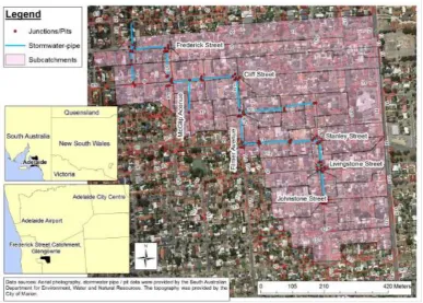
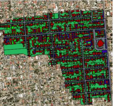
[image:7.595.105.493.256.533.2]This research report will focus on the Frederick Street catchment in Glengowrie, a suburb of Adelaide. Glengowrie is an urban area with a population density of 2480 inhabitants/km2. The area of the Frederick Street catchment is 44,7 ha. A map of the catchment, provided by the CWMR, is shown below. Over the years, infill development has taken place in the area, and this process is likely to continue. The housing development leads to an increase in impervious area, which influences the flow regime of the catchment, leading to bigger peak flows during runoff causing rainfall events. Building a new drainage system for the entire catchment is an expensive and time-consuming solution which will also cause a lot of nuisance. This is why alternative approaches are being taken into consideration. Water-Sensitive Urban Design seems a promising solution to the problem. Therefore, it has to be investigated if Water-Sensitive Urban Design can be applied in the catchment area in order to reduce the effects caused by infill development on flow frequency.
Figure 1-1: The Frederick St. catchment
8
1.2.3
Research objective
In 1993, extensive research produced data to support a reliable hydrological model for the catchment area. However, since that time the catchment area has experienced infill development, where housing numbers and impervious areas have increased on existing allotments. An example is shown in figure 1-2. This might have resulted in changing flow frequencies for the catchment area. The objective of the project will be to determine suitable WSUD measures for the catchment by producing an updated version of the catchment model using flow data being collected since August 2013. The existing model will be updated and then calibrated. When the model is calibrated, the use of several suitable WSUD measures can be simulated on the catchment to view their effect on flow frequency. It is intended that any changes which might have occurred in the area, will not have an effect on the flow regime of the catchment. Therefore, using Water-Sensitive Urban Design to maintain the old flow frequencies by improving drainage capacity is desired.
Figure 1-2: An example of housing development on Cliff street
1.3
Research questions
Main question:
How can the existing flow regimes of the Frederick Street catchment be preserved after the redevelopment of the catchment area?
Subquestions:
What is the current flow regime of the study area?
How has/will the redevelopment of the catchment area affect the flow regime?
Which WSUD-related solutions are available and how well will they be able to preserve the flow regimes?
How can Water-Sensitive Urban Design be used effectively to maintain the current flow frequency?
9
1.4
Research methods
In order to answer the research questions, the assignment is structured in an orderly way. The first two subquestions require a good understanding of the flow regime and a realistic runoff model. After that, the WSUD principles will be simulated in order to develop recommendations. The entire process is described briefly below.
In order to work with a reliable and up-to-date model, changes in the area of the catchment need to be taken into account (for example housing development or changes in soil conditions). The most important change in the Frederick Street catchment will be housing development, which leads to an increased impervious area. First, the percentage of growth of the impervious area needs to be investigated. In order to assume the growth percentage of impervious area within the catchment, available data about the catchment area will be updated by using the spatial information system QGIS and satellite images from 1993 and 2013. Changes in the amount of pervious and impervious area will be analysed and then used to update the model in EPA SWMM. After this, the model will be calibrated. Model parameters include for example storage losses, Manning’s n values for pervious and impervious areas and infiltration rates for soil. All relevant model parameters will be analysed to ensure a good calibration. Most of this information can be found in the flow frequency analysis in chapter 3.
Following the calibration, the model will be used to simulate Water-Sensitive Urban Design principles, in order to develop recommendations for implementing WSUD at the allotment level (with infill development) or in the streetscape in the catchment to preserve the existing flow regime at 1993 levels. This report focusses on distributed systems throughout the catchment. Examples of WSUD measures which can be simulated using the model are rainwater tanks or rain gardens. The model will also be used to simulate the flow regime of the catchment in 2040. For that year, a number of scenarios (with and without WSUD measures) will be analysed in order to determine whether Water-Sensitive Urban Design can be an effective way to reduce peak flows in the Frederick Street catchment in the future. The result will be a newly calibrated model with updated spatial information, and an overview of the flow regimes in 1993, 2013 and the predicted flows for 2040 with and without several Water-Sensitive Urban Design measures. The analysis of WSUD effectiveness in chapter 4 explains all of this in more detail.
1.5
Importance of the research
10
2
Theoretical context
In this chapter, an overview of the field of Water-Sensitive Urban Design and the software which was used during the project is given. All of these subjects will be explained briefly below.
2.1
Water-Sensitive Urban Design (WSUD)
This section will give an overview of the main principles of Water-Sensitive Urban Design and several suitable WSUD measures for the Frederick Street catchment.
2.1.1
What is Water-Sensitive Urban Design?
Water-Sensitive Urban Design (WSUD) is an approach to urban planning and design that integrates the management of the total water cycle into the urban development process. It includes:
Integrated management of groundwater, surface runoff (including stormwater), drinking water and wastewater to protect water related environmental, recreational and cultural values;
Storage, treatment and beneficial use of runoff and wastewater; Using vegetation for water quality purposes;
Utilising water saving measures to minimise requirements for drinking and non-drinking water purposes.
Therefore, Water-Sensitive Urban Design incorporates all water resources, including surface water, groundwater, urban and roof runoff and wastewater (Local Government Association of South Australia, 2009).
[image:10.595.71.512.451.654.2]Water-Sensitive Urban Design can play an important role in improving drainage capacity. Because most WSUD measures focus on retention of rainfall, peaks in drainage flows during heavy rainfall can be reduced, and the drainage will be spread out across a longer period of time.
Figure 2-1: The natural, urban and WSUD water balance
11
2.1.2
Water-Sensitive Urban Design in practice
There is a wide range of WSUD measures which can be applied to new developments in the greater Adelaide region. The South Australian government documented 16 different kinds of WSUD measures which are suitable in the state. These measures vary from small to extensive measures, and take into account water quality and/or water quantity. A brief summary of all WSUD measures can be seen in appendix A. From all possible options, the measures which suited the purpose of this project (reduction of peak flows and runoff volumes) and the urban environment of the Frederick Street catchment (infill development, relatively flat terrain) best, were selected. The selected measures can be installed with new development progress, unlike larger systems such as wetlands which require a lot of space. The selected measures will be explained briefly below.
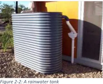
2.1.2.1 Rainwater tanks
A rainwater tank is designed and to capture and store rainwater from gutters or downpipes on a building. A rainwater tank only collects rainwater or mains water. Captured water is then available for commercial, industrial or domestic uses (Local Government Association of South Australia, 2009). Rainwater from a tank can be used to irrigate gardens or meet interior demands. The rainwater storage can be refilled more often if the tank is used to meet interior demands, because this uses water at a more constant rate. Using rainwater for a combination of uses can lead to optimum mains water saving and possibly large
reductions in runoff charges for the catchment. It should be noted that rainwater tanks provide limited water quality control, primarily through sedimentation processes. This can be enhanced by elevating the outlet to a height greater than 100 millimetres above the tank floor.
It is currently mandatory for class 1 buildings, as defined in the Australian Building Code, to have an alternative mains water supply, which is often met through installation of a rainwater tank plumbed into the dwelling. There are a number of standards which apply to the construction and installation of rainwater tanks. More information on this can be seen in appendix E. The most important requirement regarding the reduction of peak flows is that every new dwelling is required to have an additional water supply for mains water. The most popular way to meet this requirement is by connecting a rainwater tank of at least 1kL, plumbed for internal use, to the house.
2.1.2.2 Bioretention basins
Bioretention systems are Water-Sensitive Urban Design measures that involve some treatment by vegetation prior to the filtration of runoff through a prescribed media. Following treatment, water may infiltrate to the subsoil. The most common implementations of bioretention systems for streetscapes are bioretention swales and bioretention basins. For an urban area with very little available space, such as the Frederick Street catchment, bioretention basins seem to be the most appropriate measure.
Bioretention basins provide water quality treatment as well as flow control. A bioretention basin is characterised by the ability to detain
[image:11.595.345.525.240.387.2] [image:11.595.388.524.596.751.2]12
However, the low void ratios of soils used in these systems (typical value is 0.2) and their limited infiltration rates (typically 150 to 300 mm/h) limits their potential to provide flood control. An approximation of the available flood storage volume is a combination of 20% of the soil volume plus the above lying ponding volume, although in practice the available soil storage is unlikely to be fully utilised during a high intensity storm event (Local Government Association of South Australia, 2009).
2.2
Software
This section will provide an overview of the software used during the project. Working with the Storm Water Management Model (SWMM) was one of the main tasks of this project.
2.2.1
Quantum Geographic Information System (QGIS)
QGIS (version 2.2) was used as the main spatial information software for this assignment. It is an application that provides data viewing, editing, and analysis capabilities. QGIS was used to map the changes per subcatchment in pervious/impervious area within the catchment. This was done using satellite images from 1993 and 2013.
2.2.2
Storm Water Management Model (SWMM)
The modelling software used for this project is the Storm Water Management Model (version 5.1) by the United States Environmental Protection Agency, referred to as EPA SWMM. The software is available via the website of the United States Environmental Protection Agency.
“EPA SWMM is a dynamic rainfall-runoff simulation model used for single event or long-term (continuous) simulation of runoff quality and quantity from primarily urban areas. The runoff component of SWMM operates on a collection of subcatchment areas that receive precipitation and generate runoff and pollutant loads. The routing portion of SWMM transports this runoff through a system of pipes, channels, storage/treatment devices, pumps, and regulators. SWMM tracks the quantity and quality of runoff generated within each subcatchment, and the flow rate, flow depth, and quality of water in each pipe and channel during a simulation period compromised of multiple time steps.” (Rossman, 2007)
2.2.3
Parameter estimation software (PEST 13.0)
[image:12.595.353.526.374.521.2]PEST is a software package for model-independent parameter estimation and uncertainty analysis. During this project, version 13.0 of PEST was used to aid the calibration of the model. PEST 13.0 runs on DOS and can be used for parameter definition and recognition, observation definition and recognition and predictive analysis (Doherty, 2010). For this project, PEST was used to calibrate the values of a number of soil characteristics. More information about the calibration of the model can be found in section 3.2.
13
3
Flow frequency analysis
This chapter gives insight in the flow regimes of the catchment, and shows how redevelopment of the area will affect the flows and runoff volumes of the area.
3.1
Available data
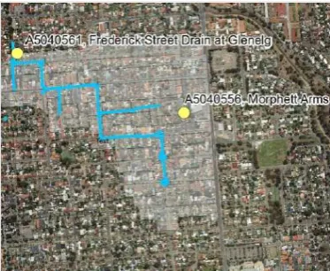
The available data consists of measurements from two rainfall gauges (at Frederick Street and the Morphett Arms hotel, see Figure 3-1) and one flow gauge, located at the bottom of the catchment at Frederick Street. Data from between 09-08-2013 and 24-05-2014 was made available by Water Data Services Pty Ltd, the company which is responsible for the management of the gauges. The data from this period was verified and was continuous. All data was available in 5-minute time steps. The recorded rainfall per gauge was provided in steps of 0.2 mm for both gauges, and the flow gauge at Frederick Street also provided information other information (flow, depth, velocity, pH, water temperature, etc.).
3.2
Calibration of the model
Previous modelling of the Frederick Street catchment was undertaken by Kemp (2002) who used runoff flow data from the catchment in 1993 and 1994 to verify that the ILSAX (stormwater drainage) model was suitable for simulating runoff in urban catchments. The input data to the model used by Kemp was based on data collected in the Frederick Street catchment in and around 1992-1993 as part of the original monitoring of the catchment by the ‘Q/Q Group’. (Argue, Good, & Mulcahy, 1994) The catchment’s contributing areas (pervious, directly connected impervious and supplementary paved areas) for the ILSAX model were determined by analysis of aerial photography and on-site inspection. Based on the on-site inspection, the catchment was dived into 54 subcatchments.
[image:13.595.337.524.172.325.2]This model, referred to as the ‘1993 model’, has been used as the basis for the 2013 model. The 1993 model is calibrated to rainfall from between 1993 and 1994. However, after running the model with data from 2013, it became clear that while the model was calibrated well to suit the specific 1993-1994 rainfall events, it did not provide a reliable model for other periods of time. This is a common mistake made in modelling. (American Society of Civil Engineers, 1993). This meant the model, at that stage, was not good enough (yet) to be able to successfully simulate the impact of infill development and the effectiveness of WSUD principles to reduce this impact. Further adjustments had to be made in order to get a good and reliable model.
14 First, the spatial information of the area was updated to 2013. In twenty years, a few dozen new houses were built within the catchment. Also, a lot of ‘old’ houses have been expanded by adding extensions to them. Changes in driveways, sidewalks and gardens was also taken into account. All the new information was then used to calculate the new values for impervious/pervious areas. The programme used to do this was QGIS.
In QGIS, the surface areas where categorised using four different layers: roads, roofs, directly connected impervious area and indirectly connected impervious area. Roads and roofs are directly connected to the drainage system. Directly connected impervious area are the pieces of land where runoff is directly connected to the drainage system by travelling over other impervious area, whereas indirectly connected impervious areas do not connect directly to the drainage system and first have to travel over pervious area. This categorisation is important because each layer has its own values for runoff time and volumetric runoff coefficient. Also, there is a difference in water quality between these layers, but this is not directly relevant for this specific project. The calculated values for the different layers were then used to update the SWMM model.
Overall, a 4% increase in impervious area was noted. Changes were found in 31 out of 54 subcatchments, which led to an 18950 m2 increase of impervious area in total. 48
[image:14.595.338.527.72.247.2]buildings were removed, while 118 new buildings were erected. The mean area of the removed buildings was 196 m2, while the mean area of new allotments was 242 m2. A quick overview of the new mean values for the catchment can be seen in table 3-1.
Table 3-1: Summary of catchment properties for the Frederick Street catchment
Catchment property 1993 2013
Total area (ha) 44,7 44,7
Directly connected impervious area* (%) 30% 34% Indirectly connected impervious area (%) 17% 17%
Pervious area (%) 53% 49%
* The directly connected impervious area includes roads and roofs.
The most remarkable changes compared to the old model are the adjustments to the soil characteristics. In SWMM, there are three choices for modelling infiltration: Horton’s equation, the Green-Ampt method and the Curve Number method. These are all common methods for infiltration modelling. For this project, Horton’s equation was used.
[image:14.595.339.526.279.441.2]Horton’s equation is a method based on empirical observations. The theory is based on the fact that infiltration is faster in dry ground, so as rain continues and the ground becomes wetter, the infiltration Figure 3-2: Representation of the catchment in QGIS
[image:14.595.71.363.565.634.2]15
rate decreases. The reason that infiltration is faster when the ground is dry is that there are more spaces for the water to fit so capillary forces that pull the water down into the ground are stronger. Horton’s equation assumes that infiltration decreases exponentially from an initial maximum rate to some minimum rate over the course of a long rainfall event. Input parameters required by the method include the maximum and minimum infiltration rates, a decay coefficient that describes how fast the rate decreases over time, and a drying time for fully saturated soil. Horton’s equation is a commonly used infiltration modelling method, but like every model it has its limitations. The method assumes that the rainfall rate, R is greater than the infiltration rate throughout the rain. If at any time the rainfall rate is slower than the infiltration rate, the ground will lose some water to lower levels, and Horton's theory must be modified in order to provide a realistic prediction. (Aron, 1992)
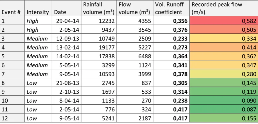
[image:15.595.72.524.296.513.2]The data was analysed by looking at the 12 biggest rainfall events during the study period. Their characteristics are shown below. The intensity of the events was categorised into three different categories: low (< 0.2 m3/s), medium (0.2 to 0.5 m3/s) and high (> 0.5 m3/s).
Table 3-2: The selected 12 storm events
Event # Intensity Date
Rainfall volume (m3)
Flow volume (m3)
Vol. Runoff coefficient
Recorded peak flow (m/s)
1 High 29-04-14 12232 4355 0,356 0,582
2 High 2-05-14 9437 3545 0,376 0,505
3 Medium 12-09-13 10749 2509 0,233 0,334
4 Medium 13-02-14 19177 5227 0,273 0,414
5 Medium 14-02-14 17838 6488 0,364 0,362
6 Medium 5-05-14 3299 1124 0,341 0,347
7 Medium 9-05-14 10593 3999 0,378 0,280
8 Low 21-08-13 2745 837 0,305 0,145
9 Low 2-10-13 1697 533 0,314 0,119
10 Low 8-04-14 1133 270 0,238 0,090
11 Low 2-05-14 776 324 0,417 0,087
12 Low 9-05-14 5241 2187 0,417 0,155
16
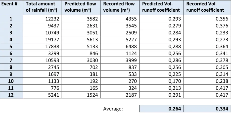
Table 3-3: Predicted and recorded runoff coefficients for 12 selected events in 2013 and 2014 Event # Total amount
of rainfall (m3)
Predicted flow volume (m3)
Recorded flow volume (m3)
Predicted Vol. runoff coefficient
Recorded Vol. runoff coefficient
1 12232 3582 4355 0,293 0,356
2 9437 2631 3545 0,279 0,376
3 10749 3051 2509 0,284 0,233
4 19177 5613 5227 0,293 0,273
5 17838 5133 6488 0,288 0,364
6 3299 846 1124 0,256 0,341
7 10593 3030 3999 0,286 0,378
8 2745 702 837 0,256 0,305
9 1697 381 533 0,225 0,314
10 1133 192 270 0,170 0,238
11 776 165 324 0,213 0,417
12 5241 1524 2187 0,291 0,417
Average: 0,264 0,334
In order to get a better understanding of the effects of the soil saturation on the volumetric runoff coefficient, the available data was analysed. The results can be seen in figure 3-4 and appendix D. In can clearly be seen that the rainfall in previous days (known as the Antecedent Precipitation Index, or API) does have a significant effect on the volumetric runoff coefficient. This is something the old model seemed to underestimate, given the relatively low and non-variable values for the runoff coefficient it produced. For the 5-day API, a common time period for this kind of research (Kjelsen, 2007), an increase from roughly 0.30 to 0.40 was noted for the storm events with respect to dry and very wet antecedent days in 2013 and 2014. This pointed in the direction of a relation between antecedent wetness and volumetric runoff coefficient for these short storm events. The results of the analysis were not conclusive, but reasonable R-squared (coefficient of determination) values (around 0.4 to 0.5) indicated there might be a relation. This was then taken into account for the new calibration of the model.
17
[image:17.595.109.487.233.452.2]A remarkable finding was that a longer time span than commonly used seemed to predict the runoff coefficient best. Although the 5-day antecedent wetness (API5) is a commonly used characteristic, results indicate that a longer time span might be more suitable to predict the runoff coefficient in this catchment. As figure 3-4 shows, the coefficient of determination for API14 is the highest and therefore best. However, further research is needed to prove this hypothesis. It should be noted that soil saturation measurement through collection of soil samples would have resulted in a more accurate analysis. Field work might be a good recommendation for further research. However, for this project the confirmation that soil characteristics seem to influence the flow rates is sufficient. This means the soil characteristics will get a more prominent place in the calibration than previously assumed.
Figure 3-4: Coefficient of determination for the antecedent wetness 0,061
0,364 0,384
0,443
0,510
0,409
0 0,1 0,2 0,3 0,4 0,5 0,6
0 5 10 15 20 25
Coe
ff
ici
en
t
o
f d
eterm
in
at
ion
(R
2)
Days before storm event taken into account (API)
18
[image:18.595.70.526.125.342.2]The 2-, 5-, 7-, 14- and 21-day API graphs are shown in appendix E. The graph for the 5-day API, with the 12 selected events labelled, is also shown below. An increase in volumetric runoff coefficient for periods with high amounts of rainfall can be seen.
Figure 3-5: Antecedent rainfall vs. runoff coefficient for 12 (numbered) storm events
After all these findings the model was re-calibrated using the new area values, 2013-2014 rainfall data from both gauges and the new insights on soil characteristics. The parameter estimation software used to do this was PEST. This led to the key parameters as shown in table 3-4.
Table 3-4: Key properties of the Frederick Street model
Model parameter Unit Initial value Final value
Impervious area roughness, Nimp - 0.01 0.01
Pervious area roughness, Nperv - 0.03 0.032
Maximum soil infiltration rate (mm/hr) 100 100
Minimum soil infiltration rate (mm/hr) 8 3.440
Decay h-1 2 2.261
Drying time days 5 2.723
Impervious area depression storage (loss), Simp mm 0.5 0.579 Pervious area depression storage (loss), Sperv mm 5 2.990
3.3
Data validation
Furthermore, the recorded rainfall at the two gauges was validated. There were no strange gaps or peaks in the data provided. However, one rain gauge recorded a 17% larger volume of rain than the other, which might seem odd, given that the gauges are located about a kilometre from each other. After these findings, the data was sent to Water Data Services, the company who provided the rain gauge data, in order for it to be checked and to see if both gauges functioned normally. Water Data Services did not find any strange circumstances which might explain the difference. After this, a site visit was conducted, but this also did not bring to light any circumstances which might explain the difference (for example an object blocking the gauges). Therefore, it was assumed the measures amounts of rainfall at both gauge locations were accurate enough to use for the simulations.
1 2 3 4 5 6 7 8 9 10 11 12 0,000 0,050 0,100 0,150 0,200 0,250 0,300 0,350 0,400 0,450
0,0 5,0 10,0 15,0 20,0 25,0 30,0 35,0 40,0 45,0
Volu m etric ru n o ff coef fici en t
API5 (mm)
[image:18.595.69.530.445.574.2]19
4
Analysis of WSUD effectiveness
Now that an understanding of the flow regimes and the effects of infill development have been established, the effectiveness of the WSUD measures can be analysed.
EPA SWMM was used to determine the effectiveness of several Water-Sensitive Urban Design measures for the catchment. As well as the effectiveness, the viability of the measures will also be briefly assessed.
4.1
Design of the analysis
After the calibration of the model and validation of the data, the model could be used to analyse the effectiveness of several Water-Sensitive Urban Design principles on flow frequency. For the analysis, three benchmark years have been set: 1993 (old situation), 2013 (current situation) and 2040 (several potential development scenarios). Below, a short summary will be given of their characteristics.
Rainfall data Spatial data WSUD?
1993 2013-2014 1993 land use No
2013 2013-2014 2013 land use 1-kL rainwater tank for
houses after July 2006
2040, no measures 2013-2014 2013 land use + prediction No new measures
2040, rainwater tanks 2013-2014 2013 land use + prediction 1-,2-, and 5-kL
Rainwater tanks 2040, Bioretention
systems
[image:19.595.74.528.701.775.2]2013-2014 2013 land use + prediction Bioretention basins Table 4-1: Overview of characteristics for 1993, 2013 and 2040
For 2013, it was assumed that all houses built after July 2006 were fitted with a 1 kL rainwater tank, connected to a roof area of 50 m2. This because according to the Development Act 1993, all new houses and house extensions greater than 50 square metres are required to have an additional water supply to supplement mains water after 1 July 2006. Furthermore, the minimum required connected roof area is 50 m2. It was assumed that only the houses built after July 2006 were fitted with a rainwater tank. By using a proportion of the 1993 to 2013 development, this led to the assumption that until 2013 the number of connected rainwater tanks was 41 (the number of houses assumed to be built after July 2006), with a 1-kL rainwater tank which is connected to a roof area of 50 m2. The average water demand from the rainwater tanks currently lies around 100 L/day.
For the 2040 scenarios, it was assumed that the infill development of the past 20 years would continue at the same speed. This meant that, compared to 2013, 65 house will be demolished and 159 new ones will be built. This leads to an overall increase of 94 houses. Because of the new housing developments, it was assumed that the 159 new buildings all had 50 m2 of roof area connected to a rainwater tanks, thus leading to an additional 7950 m2 of roof area connected to rainwater tanks. Overall, the percentage of impervious area will increase to 40% of the total area.
An assessment of available space for bioretention systems was done by a site visit and the use of satellite images.
Table 4-2: Predicted change in catchment properties
Catchment property 1993 2013 2040 (prediction)
Total area (ha) 44,7 44,7 44,7
Directly connected impervious area* (%) 30% 34% 40%
Indirectly connected impervious area (%) 17% 17% 17%
20
4.2
Analysis of WSUD effectiveness on flow frequency
In this chapter the results of the simulations will be shown and discussed. The chapter is divided into three sections: rainwater tanks, bioretention basins and the detention basin. For comparison, the volumes for 2013, and the 2040 scenario without any new WSUD measures will be shown in the results as well.
Table 4-3: No WSUD prediction
Scenario Total volume of runoff (m3)
1993 35130
2013 38247
2040, no new WSUD 42987
4.2.1
Rainwater tanks
[image:20.595.70.533.356.538.2]The effectiveness of rainwater tanks on the reduction of runoff volume is shown below. The application of rainwater tanks of 1kL, 2kL and 5kL were simulated. 1kL rainwater tanks have been compulsory for all new houses since July 2006. The effect of WSUD measures for all expected new housing, as well as for all houses within the catchment has been analysed.
Figure 4-1: Volumetric runoff for several scenarios
4.2.1.1 1 kL rainwater tanks
The effectiveness of 1 kL rainwater tanks on reducing runoff volumes has been simulated using SWMM. The results are shown below.
Table 4-4: 1 kL rainwater tank simulation results
Scenario Total volume of runoff (m3)
1993 35130
2013 38247
2040, no new WSUD (prediction) 42987 2040, 1 kL rainwater tanks for new houses 42081 2040, 1 kL rainwater tanks for all houses 38418
42987
42081
41559
41106
38418
36558
34923
34000 35000 36000 37000 38000 39000 40000 41000 42000 43000 44000
V
O
LUM
ETR
IC
R
UN
O
FF
(
M
3)
NO WSUD 1 KL NEW 2 KL NEW 5 KL NEW 1 KL ALL 2 KL ALL 5 KL ALL
21 According to current legislation, every new house needs to be fitted with a 1-kL rainwater tank. If the local government decides to maintain this rule, this will lead to an expected 2% decrease of flow volumes compared to a situation without new WSUD. This is not enough to maintain the current flow regime.
Fitting all houses with a 1-kL rainwater tank leads to an 11% decrease of flow volumes, restoring them to the current level.
4.2.1.2 2 kL rainwater tanks
The effectiveness of 2 kL rainwater tanks on reducing runoff volumes has been simulated using SWMM. The results are shown below.
Table 4-5: 2 kL rainwater tank simulation results
Scenario Total volume of runoff (m3)
1993 35130
2013 38247
2040, no new WSUD (prediction) 42987 2040, 2 kL rainwater tanks for new houses 41559 2040, 2 kL rainwater tanks for all houses 36558
Not very surprisingly, the appliance of 2-kL rainwater tanks forces reduction of the flow volumes even more. Installing 2-kL rainwater tanks for new houses lead to a 3% decrease of the volume.
[image:21.595.297.524.70.229.2]Applying 2-kL rainwater tanks to every house within the catchment leads to a 15% decrease. This restores the flow volumes to a pre-2013 level, however not as low as the 1993 level.
[image:21.595.297.524.434.612.2]Figure 4-2: 1 kL rainwater tank effectiveness
22 4.2.1.3 5 kL rainwater tanks
The effectiveness of 5 kL rainwater tanks has been simulated using SWMM. The results are shown below.
Table 4-6: 5 kL rainwater tank simulation results
Scenario Total volume of runoff (m3)
1993 35130
2013 38247
2040, no new WSUD (prediction) 42987 2040, 5 kL rainwater tanks for new houses 41106 2040, 5 kL rainwater tanks for all houses 34923
The biggest rainwater tanks that were considered for the allotments in the catchment were 5-kL rainwater tanks. Bigger tanks were not seen as realistic, and even the appliance of 5-kL rainwater tanks does not seem feasible, due to the large amount of space they require.
[image:22.595.298.526.244.408.2]However, the 5-kL rainwater tanks are effective in restoring the 1993 flow levels (a 19% decrease) if applied to all houses. If applied only to new housing developments, the tanks achieve a 4% reduction.
23
4.2.2
Bioretention basins
[image:23.595.305.521.220.411.2]For the simulation of the effectiveness of street scale bioretention basins, a number of assumptions were made. The properties in table 4-7 were used for the simulation. These values are values commonly used within the CWMR, and most of them were derived from Rossman’s SWMM user manual. (Rossman, 2007). Furthermore, it was assumed that a set of basins could be integrated in the streetscape roughly every 100 metres on suitable locations. A site visit gave an insight in good ways to integrate the basins into the streets. For the simulation this resulted in 82 basins, spread out across 44 subcatchments. The locations of these basins are shown in figure 4-5.
Table 4-7: Storage and underdrain properties
Figure 4-5: Proposed locations of the bioretention basins
[image:23.595.71.296.220.461.2]*Derived from the SWMM User Manual
Table 4-8: Bioretention simulation results
Scenario Total volume of runoff (m3)
1993 35130
2013 38247
2040, no new WSUD (prediction) 42987
2040, bioretention 41562
Compared to rainwater tanks, bioretention systems seem to be less effective in reducing flow volumes, as expected. The construction of 82 bioretention basins (without impermeable liner) within the catchment leads to an expected 3% decrease of the flow volume. This is not enough to restore the pre-development levels in the catchment. However, it should be noted that bioretention systems have other advantages than just water quantity reduction. As mentioned before, the basins can have positive effects on for example water quality.
Soil storage properties
Thickness (mm) 850
Porosity (volume fraction)* 0.437 Field capacity (volume fraction)* 0.062 Wilting Point (volume fraction)* 0.024
Conductivity (mm/hr) 150
Conductivity slope 5
Suction head (mm)* 1.93
Underground storage properties
Thickness (mm) 250
Void ratio (voids/solids) 0.1
Seepage rate (mm/hr) 0.36
Clogging factor 0
Underdrain properties
Drain coefficient (mm/hr) 18.5
Drain exponent 0.51
[image:23.595.307.531.511.739.2]Drain offset (mm) 50
24
4.2.3
Peak flow reduction
Besides the reduction of volumetric runoff for several WSUD scenarios, an analysis has also been done on the predicted peak flows for the scenarios in the year 2040. This was done by looking at the twelve selected storm events. The results show that in the scenario without any new Water-Sensitive Urban Design, peak flows for the storm events would rise by 11% on average. All of the results can be found in appendix G.
The construction of rainwater tanks on new houses leads to a decrease of the peak flows compared to the scenario without Water-Sensitive Urban Design, but not enough to maintain the current peak flows. Additional measures will be needed in order to maintain the peak flows.
[image:24.595.72.419.321.558.2]A more extreme measure such as connecting every house to a rainwater tank seems to be able to maintain the current flows, or even reduce them. The most effective measure to counter rising peak flows is the bioretention scenario, leading to a 31% decrease in peak flows compared to the current levels. However, it should be noted that most of the reduction accomplished by bioretention systems is from the smaller, less extreme storm events. More about this can be seen in appendix G.
Figure 4-7: Predicted change in peak flows
-40 -30 -20 -10 0 10 20
No WSUD 1 kL new 2 kL new 5 kL new 1 kL all 2 kL all 5 kL all Bioretention
Average change in peak flows (%)
WSU
D
sce
n
ar
io
25
[image:25.595.69.525.117.369.2]A hydrograph showing an impression of the impact of applying rainwater tanks to the catchment is shown in figure 4-8. In this graph, the 5 kL rainwater tank for all houses scenario is shown. Results for other (less drastic) rainwater tank scenarios show a smaller, but similar reduction of peak flows.
Figure 4-8: Hydrograph showing the effect of the '5 kL rainwater tanks for all houses' scenario
4.3
Assessment of viability
A short assessment has been made of the viability of the simulated measures mentioned earlier in this chapter.
The size of the rainwater tanks is an important variable in the simulation of the effectiveness of the tanks. Current legislation requires every new allotment to be fitted with a 1 kL rainwater tank, connected to at least 50 m2 of roof area. Therefore, the scenario in which new houses will be equipped with 1 kL rainwater tanks is the most likely one. However, bigger tanks are also an option. Important cons about bigger tanks are the extra space they require and the fact that they are more expensive for the developers and/or residents to purchase. On the other hand, they are more effective in forcing back the peak flows and flow volumes.
Fitting every house with a rainwater tank is also an option. The results of the simulation indicate that this is an effective measure which is able to maintain the current flow regime. However, obliging all residents to install a rainwater tank requires new legislation and significant investments by local or state authorities.
The construction of bioretention basins throughout the catchment does not need new legislation. In fact, some parts of the catchment (and similar) catchments have already been fitted with similar basins, although on a smaller scale than simulated in this report. It is advised to construct the basins when roadwork is being done to minimise costs and nuisance during the construction of the bioretention basins. It is important to consider that the effectiveness of bioretention basins over a longer period of time has not been evaluated yet.
For future research it is advised to conduct a full cost-benefit analysis (installation, maintenance and running costs) of each WSUD measure in order to aid the decision making process.
0,000 0,100 0,200 0,300 0,400 0,500 0,600 0,700 0,800
0 150 300 450
Flow
(m
3/s
)
Time (minutes)
Reducing peak flows - rainwater tanks
Predicted 2013 flow
26
5
Discussion
In the end, the model gave a good understanding of the flow regimes, and proved to be a helpful aid to answer the research questions. The outcomes of the research were as expected and the report as a whole shows promising prospects for the use of Water-Sensitive Urban Design in medium sized urban catchments.
But like with every other project, several problems were encountered. First of all, when the two rain gauges in the area were compared it was found that, for the period of August 2013 – May 2014, the Frederick Street rain gauge (A5040561) received a substantially larger amount of rainfall (332 mm) than the Morphett Arms rain gauge (A5040556), which recorded only 283 mm of rainfall. This difference of 17% seems odd for two pluviometers which are located in the same urban area less than a kilometre from each other. An explanation could not be found. One possible explanation is the fact that the Frederick Street gauge (A5040561) has been replaced between 1993 and 2013, which might have led to different rain recordings. However, the gauge performed well when it was calibrated after the installation. For further research, it might be good to wait for both of the rain gauges to be recalibrated. Although no abnormalities were found by experts, the 17% difference in measured rainfall between the gauges suggests that the gauges might need a new calibration. This will be done on the next site visit by Water Data Services Ltd.
One rain gauge (A5040556) was moved approximately 60 metres to the south since the 1993 rainfall recordings. This might have led to slightly different recordings than on the old location.
February 2014 was one of the wettest summer months in the recorded history of rainfall in Adelaide. On average, Adelaide receives about 20 mm rain in February. In 2014, this was more than 80 mm (4 times the average). Such extreme weather conditions might lead to distorted model results, since the model seems to predict the extreme events not as well as common events.
Also, the influence of antecedent precipitation should be further investigated. The findings of this research suggest that taking a longer period into account than the commonly used 5-day antecedent wetness might lead to a more accurate model in the case of the Frederick Street model. However, more research needs to be done to confirm this presumption.
In order to get a more accurate understanding of the soil behaviour, it is advised to work with daily records of rainfall and evaporation. Daily evaporation records were not available for this research, only monthly averages. Furthermore, working with data from a longer time period than just 9 months might improve the quality of the research as well.
It may be debated whether Horton’s method is the best way to model the soil infiltration, since it has its shortcomings. If at any time the rainfall rate is slower than the infiltration rate, the ground will lose some water to lower levels, which might not be realistic. Other methods have their own shortcomings, and because this was the most common method used in South Australia, Horton’s equation was selected. The other options were not put to the test due to time restrictions.
The rate of infill development will probably slow down over time instead of the assumed linear increase because there are fewer allotments available for redevelopment as development progresses. This has not been considered in the projections in this report.
27
It should also be noted that the effectiveness of the WSUD measures was the main topic of this research. However, not only WSUD effectiveness and cost-effectiveness should be taken into account. Local councils and their legislation have a big impact on the decision making process when choosing which WSUD measures to apply as well.
28
6
Conclusion
The current flow regime of the Frederick Street catchment has been assessed and a model has been set up to analyse the impact of infill development on the flow regime. Redevelopment within the catchment area is expected to lead to an overall increase of 12% in runoff volume, and an 11% increase in peak flows by 2040 if no WSUD measures would be implemented.
Water-Sensitive Urban Design can be used to preserve the existing flow regimes of the Frederick Street catchment. For street scale WSUD measures, rainwater tanks and bioretention systems are showing promising simulation results for reducing runoff volumes and peak flows. The most effective way of reducing runoff volumes is the installation of rainwater tanks. Peak flow reduction on the other hand can be achieved by both rainwater tanks and bioretention basins. Although bioretention basins achieve a higher overall reduction of peak flows, it should be noted that for very extreme storm events they are not capable of significant peak flow reduction.
Therefore a mix of both small (1 kL) rainwater tanks for all houses in combination and bioretention systems seems to be the best option for preserving the flow regimes in the Frederick Street catchment. Another option is to connect every house in the catchment to a bigger (e.g. 5 kL) rainwater tank. Although the peak flows and runoff volumes would not increase as much as without Water-Sensitive Urban Design, continuation of the current policies would lead to an increase in flow volumes and peak flows. Therefore, additional action needs to be undertaken to preserve the existing flow regime. This report provides delicate, sustainable and relatively cheap solutions for the expected increase in peak flows and runoff volumes, possibly saving local governments and residents a lot of money and nuisance.
29
7
Recommendations
There are several recommendations for further research on this topic. They include recommendations for future data analysis as well as advice for the appliance of WSUD measures in the Frederick Street catchment and similar urban catchments.
It should always be taken into account that the decision on what WSUD measures to implement depends on the focus of the drainage targets. If the targets are related to runoff volume reduction, rainwater tanks are the best option. In case of peak flow related targets, a combination of rainwater tanks and bioretention basins is recommended.
There are several recommendations regarding the data analysis. First, when the rainfall gauges have been re-calibrated, new data should be compared with the old data in order to see whether the irregularities regarding rainfall measurements were caused by a bad calibration of the gauges. It is further recommended that other soil infiltration models are taken into account, this was not done for this research due to time restrictions.
Future research should include a full cost-benefit analysis of each WSUD option, as well as an investigation on the development of the amount in indirectly connected impervious area.
Before any decisions on WSUD measures are taken, it is advised to discuss the findings of the research with the involved local councils to see whether changes need to be made to current legislation. It should be noted that the results of the research are subject to sensitivity before being adopted. Assumptions have been made for parts of the project such as the water demand and soil infiltration parameters. Further research should clarify whether the assumptions made were accurate enough to justify the conclusions of this report.
Overall, the outcome of this research shows promising prospects, and therefore it is recommended to further investigate the implications Water-Sensitive Urban Design can have on preserving flow regimes in developing urban catchments. If continued, this research can contribute to cost-effective and sustainable solutions for several urban water challenges.
30
8
References
American Society of Civil Engineers. (1993). Criteria for evaluation of watershed models. Journal of Irrigation and Drainage Engineering, 429-442.
Argue, J. E., Good, K., & Mulcahy, D. E. (1994). Planning, Instrumentation and Data for an Urban Drainage Network in Adelaide, South Australia. Water Down Under, November edition, p. 287 - 294.
Aron, G. (1992). Adaptation of Horton and SCS Infiltration Equations to Complex Storms. J. Irrig. Drain Eng., 118(2), 275–284.
Doherty, J. (2010). PEST: Model-Independent Parameter Estimation, user manual 5th edition. Brisbane, Australia: Watermark Numerical Computing.
eWater Ltd. (2011). Guidelines for water management modelling. Canberra: CRC Australia.
Government of South Australia. (2009). Water for good - A plan to ensure our water future to 2050. Adelaide, SA, Australia: Government of South Australia.
Government of South Australia. (2013). Designing a WSUD strategy for your development. Adelaide, SA, Australia: Government of South Australia.
Government of South Australia. (2013). Water sensitive urban design; Creating more liveable and water sensitive cities in South Australia. Retrieved from Department of Environment, Water and Natural Resources: http://www.environment.sa.gov.au/files/516f3ac2-16ff-43fd-b078-a26900b99a81/water-sensitive-urban-design-policy-gen.pdf
Government of South Australia. (2014). South Australia's Strategic Plan. Adelaide, SA, Australia: Government of South Australia.
Kemp, D. J. (2002). The development of a rainfall-runoff-routing model (RRR). Adelaide: University of South Australia.
Kjelsen, T. R. (2007). The revised FSR/FEH rainfall runoff method. Oxfordshire, UK: Centre for Ecology & Hydrology.
Local Government Association of South Australia. (2009). Institutionalising Water-Sensitive Urban Design - Technical manual. Adelaide: Local Government Association of South Australia.
Rossman, L. A. (2007). Storm water management model, user's manual. Cincinnati, Ohio: EPA. SA DPLG. (2010). The 30-year plan for Greater Adelaide. Adelaide, SA, Australia: South Australian
Department of Planning and Local Government.
31
Appendices
32
[image:32.595.74.540.132.762.2]Appendix A: overview of common WSUD measures
Table A-0-1: Overview of WSUD measures (Government of South Australia, 2013)
# Measure More information Focus of WSUD
measure
Potential benefits Suitable
conditions Water
quality
Water quantity
1 Demand reduction Water conservation (water-efficient fixtures and appliances, etc.)
Medium High Reductions in mains water supply
Residential, commercial & industrial sites
2 Rainwater tanks
Capture and storage of rainwater
Low High Reduction in water supply and peak runoff rates
Proximity to roof
3 Rain gardens Gardens with runoff directed into them
Medium High Peak runoff reduction, water quality and biodiversity benefits Allotment scale
4 Green roofs Vegetated roof covers
Medium Medium Water retention, biodiversity benefits
Flat roofs
5 Infiltration systems
Shallow excavated trenches
High Medium Reduce surface runoff, water quality benefits
Sandy soils with deep groundwater
6 Pervious pavements
Porous/permeable pavements
High Medium Retention and detention of runoff, minimise sediment export Allotments areas with low amounts of traffic
7 Urban water harvesting and reuse
Collection of water resources (ponds, wetlands,
rainwater storage, etc.)
Medium High Storage, reduction in mains water supply, recreation
Areas with a lot of space and high demand
8 Gross
pollutant traps
Remove large solids from drainage system
High Low Reduction of litter, debris and
sediment
Site and precinct scales
9 Bioretention
basins
Filtration/ bioretention trenches
High Low Water quality, street amenity, flood retardation
Flat terrain
11 Swales Linear depressions capable of
capturing runoff
Low Low Reducing runoff, positive effects on biodiversity and amenity
Flat terrain or mild slopes
12 Buffer strips Broad depressions capable of
capturing runoff
High Low Reducing runoff, positive effects on biodiversity and amenity
33
13 Sedimentation basins
Coarse sediment capture in basins
High Medium Good pre-treatment for wetlands or
bioretention basins
Big areas of flat land
14 Constructed wetlands
Created versions of natural wetlands
High High Water quality, reduces runoff, ecological and recreational value
Big areas of flat land
15 Wastewater management
Reuse of
waterwater on site
Medium High Nutrient reduction to receiving environments, mains water reduction
Residential, commercial & industrial sites
16 Syphonic roofwater systems
Roofwater harvesting for tall or large buildings
Low High Reduction in water supply and peak runoff rates
34
Appendix B: preliminary investigation study area
In 1993, extensive research has produced a reliable hydrological model for the Frederick St. catchment area. The model was calibrated using rainfall data from that period. However, it had to be investigated whether the model would also work properly when new rainfall data and new area information was added.
In order to investigate this, continuous 5-minute rainfall data from August 2013 – May 2014 was used to see whether the 1993 model still provided a good estimation of the flows in the catchment. Rainfall events which led to a substantial amount of rainfall (and flows bigger than 0.2 m3/s) were selected to see whether the model could still be used for stormwater modelling. 12 rainfall events were selected and simulated using EPA SWMM. The results can be seen on page 36.
The results show that the model in EPA SWMM both over- and underpredicts the flows within the catchment with the 2013-2014 rainfall data. One might have expected the simulated values to be lower than the actual flow values. This because of the infill development which has occurred, which will most likely lead to more extreme peaks due to the increase of impervious area. However, in the model this did not happen in most cases. Therefore, further investigation of the catchment area was needed in order to see whether this problem could be solved by updating the percentages of pervious and impervious area per subcatchment.
[image:34.595.70.531.474.683.2]The spatial information system QGIS was used to do this update. This was done using satellite images from 2013. For most subcatchments, the new satellite images showed an increase in impervious area (leading to increased peak flows). This was then incorporated into the model. Twelve ‘rainfall events’ where selected between August 2013 and May 2014 to test the accuracy of the model. Their intensity was categorised as either ‘high’ (flows of > 0.5 m/s), ‘medium’ (flows between 0.2 m/s and 0.5 m/s) or ‘low (flows of < 0.2 m/s) ’ based on the peak flow. After applying the new spatial information the model still didn’t perform well. An example of this is given in figure 1.
Figure B-1: Actual flows vs. predicted flows for a storm event on 12-09-2013. The blue line represents the prediction with 2013-2014 rainfall data using the old (1993) model. The grey line represents the non-calibrated run with updated spatial information.
0,000 0,100 0,200 0,300 0,400 0,500 0,600 0,700
0 150 300 450
Flow
(m
3/s
)
Time (minutes)
Event 1
Predicted (EPA SWMM)
Actual flow
35
Other things that should be taken into account include the following: When the two rain gauges in the area were
compared it was found that, for the period of August 2013 – May 2014, the Frederick Street rain gauge (A5040561) received a substantially larger amount of rainfall (332 mm) than the Morphett Arms rain gauge (A5040556), which recorded only 283 mm of rainfall. This difference of 17% seems odd for two pluviometers which are located in the same urban area less than a kilometre from each other.
A new rain gauge has been installed at the Frederick Street gauge (A5040561), which might have led to different rain recordings than previous.
One rain gauge (A5040556) was moved approximately 60 metres to the south.
[image:35.595.313.561.90.325.2] The value for the volumetric runoff coefficient is varying per event. The most important factor that causes this seems to be the saturation of the soil. For events which are preceded by a long period of dry weather, the runoff coefficient is low, whereas it is high for periods with a lot of rainfall. Saturation of the soil can lead to pervious area runoff occurring which might explain the varying coefficients. Coefficients between 0.25 and 0.40 seem likely for this kind of land use during storm events (Urban Drainage and Flood Control Dictrict, 2007).
Figure B-3: Difference between the amounts of recorded rainfall.
By looking at the total volume of water generated by the events and the predicted and actual runoff volumes, it became clear that the model didn’t function well anymore and needed further calibration. A remarkable finding was that the model, based on data in 1993 to 1994, seemed to have a stable volumetric runoff coefficient (roughly between 0.25 and 0.30 for the 12 selected rainfall events) while in reality the runoff coefficient proved to me more variable. One possible explanation for this is that
0 50 100 150 200 250 300 350 ra in fall (m m )
Time & Date
Total amount of recorded rainfall
Rainfall Frederick St.
Rainfall Morphett Arms
Difference 0 5 10 15 20 25 30 35 40 45 50
0 10 20 30 40 50
Rainfall A50 40 55 6 (m m )
Rainfall A5040561 (mm)
Recorded rainfall (mm)
[image:35.595.74.542.458.647.2]36
[image:36.595.75.519.159.291.2]the old model overestimated the impervious area for the catchment, and underestimated the influence of the soil/pervious area in predicting the flows.