Accepted Manuscript
An Assessment of Static Precise Point Positioning using GPS only, GLONASS only, and GPS plus GLONASS
J. Mohammed, T. Moore, C. Hill, R.M. Bingley, D.N. Hansen
PII: S0263-2241(16)30016-1
DOI: http://dx.doi.org/10.1016/j.measurement.2016.03.048
Reference: MEASUR 3906
To appear in: Measurement
Received Date: 16 January 2016
Revised Date: 8 March 2016
Accepted Date: 23 March 2016
Please cite this article as: J. Mohammed, T. Moore, C. Hill, R.M. Bingley, D.N. Hansen, An Assessment of Static Precise Point Positioning using GPS only, GLONASS only, and GPS plus GLONASS, Measurement (2016), doi:
http://dx.doi.org/10.1016/j.measurement.2016.03.048
1
An Assessment of Static Precise Point Positioning using GPS only, GLONASS
only, and GPS plus GLONASS
J. Mohammed PhD student in NGI, The University of Nottingham, UK and assistant lecturer in Civil Engineering
Department, College of Engineering, University of Wasit, Iraq, (corresponding author). E-mail: [email protected]
T. Moore Director of The Nottingham Geospatial Institute (NGI) at The University of Nottingham and Professor of
Satellite Navigation, NGI, University of Nottingham, UK, [email protected]
C. Hill Associate Professor, Nottingham Geospatial Institute, University of Nottingham, UK,
R. M. Bingley , BIGF Head of Facility and Associate Professor and Reader in Geodetic Surveying, NERC British Isles
continuous GNSS Facility (BIGF), University of Nottingham, UK, [email protected]
D. N. Hansen Product Developer, NERC British Isles continuous GNSS Facility (BIGF), Nottingham Geospatial
Institute, University of Nottingham, [email protected]
Abstract: The aim of this paper is to look into the achievable repeatability and accuracy from Precise Point Positioning
(PPP) daily solutions when using GPS only (PPP GPS), GLONASS only (PPP GLO), and GPS plus GLONASS (PPP
GPS+GLO) for static positioning. As part of the assessment, a comparison with global double difference (DD) GPS
daily solutions is presented. It is shown, therefore, that all of the PPP daily solutions can achieve millimetric level
repeatability, similar to the global DD GPS solutions. Furthermore, the mean of the biases between the PPP daily
solutions and the global DD GPS daily solutions are constellation type dependent, while an improvement is found in the
vertical component for PPP GPS+GLO over PPP GLO, as the latter may be more affected by any imperfections in the
models for GLONASS antenna phase centre variations. It is concluded that PPP GLO daily solutions have the ability to
be used as independent solutions to PPP GPS daily solutions for static positioning, and as an alternative to PPP
GPS+GLO or global DD GPS daily solutions.
2 Introduction
Different GNSS constellations are available these days. This has led to an increase in the number of satellites available
for the user, and the potential for improvements in the repeatability and accuracy of daily solutions for static
positioning, which are significant factors when evaluating the use of multi-constellations as one constellation or a
combination. At the same time, the Precise Point Positioning (PPP) technique (Zumberge et al., 1997) has also
developed to potentially provide daily solution estimates with millimetric level repeatability and accuracy for static
positioning (Larson et al., 2004), as an alternative to the double-difference (DD) technique. Following the restoration of
the GLONASS constellation to a similar level as the GPS constellation, much research has been carried out on PPP
when using GPS only (PPP GPS) and PPP when using GPS plus GLONASS (PPP GPS+GLO), i.e. using GLONASS as
an aid to GPS. For instance Cai (2009) concluded that when using PPP GPS+GLO as opposed to PPP GPS,
improvements in accuracy were 40% and 28% in the east and north components respectively and 24 % in the vertical
coordinate component. However, according to Cai and Gao (2013) the accuracy will not be significantly improved if
there are sufficient numbers of GPS satellites with good geometry. Separately, Reussner and Wanninger (2011) showed
that GPS+GLO had a reduced average horizontal coordinate error when compared to PPP GPS, Jokinen et al. (2013a)
found that when changing from PPP GPS to PPP GPS+GLO the average vertical and horizontal coordinate errors were
reduced by 17% and 4% respectively, and Jokinen et al. (2013b) showed that horizontal, vertical and 3D coordinate
errors were reduced by 40%, 24% and 32% respectively when considering PPP GPS+GLO instead of PPP GPS. Alcay
et al. (2012) concluded that there is no significant difference between GPS and GPS+GLO for two networks, however
they concluded that GLO is not accurate as GPS or GPS+GLO. While Anquela et al. (2013) concluded that PPP GLO is
not accurate as PPP GPS or PPP GPS+GLO in either static or kinematic. Clearly, all of this previous research has
tended to focus on comparisons of PPP GPS and PPP GPS+GLO, without any evaluation of PPP GLO itself. Hence, in
this paper, as an investigation of the potential benefits to static positioning from using PPP with a single or
multi-constellation, the achievable repeatability and accuracy from PPP GLO daily solutions, as independent solutions to PPP
GPS daily solutions, and as an alternative to PPP GPS+GLO or global DD GPS daily solutions, will be assessed.
PPP Daily Solutions Methodology
All of the PPP daily solutions presented in this paper were processed using the POINT software, which was developed
as part of the iNsight project (www.insight-gnss.org). The POINT software is programmed in C++, and its core is the
3
Undifferenced observations are used for each PPP daily solution, with the general observation equations for code and
phase being as follows:
For pseudo-range using C/A-Code on L1:
(1)
For Pseudo-range using on L1,L2:
(2)
For carrier phase
(3) Where:
i is the satellite index;
F represents the index of the GNSS frequency - for GPS satellites F = 1 (GPS L1) and F = 2 (GPS L2), while for GLO
satellites F = 1 (GLO L1) and F = 2 (GLO L2) with
(4)
(5)
and
k represents the frequency channel; = 1602 MHz for GLONASS L1 band; = 562.5 kHz frequency separation
between GLONASS carriers in the L1 band; = 1246 MHz for GLONASS L2 band; = 437.5 kHz frequency
separation between GLONASS carriers in the L2 band.
represents the geometric distance from the receiver to the satellite; is the receiver clock offset; is the satellite clock offset; is the first-order ionospheric bias term; is the second-order ionospheric bias term; fF is the GNSS
frequency in Hz; is the tropospheric bias; is the multipath error for pseudo-range measurements on the
frequency F; is the multipath error for C/A code measurements on L1; is the multipath error for carrier-phase
4
noise for the C/A code measurements on L1; is the noise for the carrier-phase measurements on the frequency F;
is the receiver code bias for pseudo-range measurements on the frequency F; is the receiver code bias
for C/A code measurements on L1; is the satellite code bias for pseudo-range measurements on the frequency
F; is the satellite code bias for C/A code measurements on L1; is the wavelength on the frequency F; is
the carrier phase ambiguity term on the frequency F; is the receiver fractional cycle bias (FCB) on the frequency F;
is a satellite fractional cycle bias (FCB) on the frequency F.
For all of the PPP daily solutions, a decoupled receiver clock is applied for both GPS and GLO (Collins et al., 2010),
and the ionospherically-free observable is used, with no second order ionospheric bias corrections applied. The
ionospherically-free combinations for the code and phase observables follow (Dach et al., 2007a):
(6)
(7)
Where:
P3 and L3 refer to the ionospherically-free code and ionospherically-free carrier combinations respectively; and
refer to the pseudo-range measurements on L1 and L2 respectively; L1 and L2 refer to carrier phase measurements on L1
and L2 frequency; fi is the frequency on the L1 carrier; fj is the frequency on the L2 carrier; and i = 1, j = 2 for GPS and
GLO, except that for GLO f1 and f2 come from equations (4) and (5).
In terms of the troposphere, the hydrostatic component of the zenith total delay is modelled using Saastamoinen
(Saastamoinen, 1973) and the wet component of the zenith total delay is estimated as a state in the Kalman filter for
every epoch, i.e. at 30 second intervals. For describing how the slant tropospheric delay varies with respect to the
receiver-to-satellite elevation angle, the Niell Mapping function (Niell, 1996) or NMF is used. The azimuthal
inhomogeneity of the troposphere is also taken into account by estimating two states for tropospheric gradient (E, N)
using the Chen model (Meindl et al., 2004) and the Chen mapping function (Chen and Herring, 1997) to map the
tropospheric gradient into the range domain. The Differential Code Bias (DCB) between C1 and P1, and between C2 and
P2 are corrected using the products from the Centre for Orbit Determination in European (CODE) (Dach et al., 2007a).
To look at the actual performance of the individual constellation, no weighting functions are applied to the observations,
except for the measurement noise standard deviations that is needed for the EKF and is set to 2.0 m for pseudo-range
measurements, and 0.01 m for carrier phase measurements, for both GPS and GLO.
5
Natural Resources Canada (NRCan) final precise ephemeris products are used as input, for satellite coordinates and
satellite clock corrections; satellite and receiver antenna phase centre offsets and variations are corrected using an
Antenna Exchange Format (ANTEX) (Kouba, 2009) file from the IGS, i.e. the I08.ATX file which is consistent with
what was used in the creation of the precise ephemerides;periodic deformations of the Earth’s crust as solid Earth tides
and ocean tidal loading are taken into account following Kouba (2009); phase wind up correction is also applied in
accordance with Wu et al. (1993). Sub-daily pole and nutation motions are corrected according to the IERS conventions
(McCarthy and Petit, 2004). Lastly, for all of the PPP daily solutions the carrier phase ambiguities were not fixed to
integers, but kept as float, and the cycle slip detection method implemented follows Liu (2011).
Global DD GPS Daily Solutions Methodology
All of the global DD GPS daily solutions presented in this paper were processed using the Bernese software version 5.2
(Dach et al., 2007b) . These daily solutions were created by the NERC British Isles continuous GNSS Facility (BIGF)
from a re-processing and re-analysis of daily data from 1997 to 2014. The daily solution coordinate estimates were
created using: C13 (CODE repro2/repro_2013) re-analysed satellite orbit and earth orientation parameter products; a
global network, the IGb08 reference frame; mitigation of 1st
and higher order (2nd and 3rd
order and ray bending)
ionospheric effects; a-priori modelling of troposphere effects using VMF1G and mitigation using zenith path delay and
gradient parameters; I08.ATX models for antenna phase centre variations; ambiguities were fixed to integer; and
models for Solid Earth tides, ocean tidal loading and atmospheric tidal loading. A total of approximately 150
continuous GNSS stations (CGNSS) in the British Isles, including 100+ that are part of the Ordnance Survey of Great
Britain (OSGB) national network, were included in the processing along with some 200+ IGS stations, as illustrated in
Figure 1. The epoch of the DD solutions is the observed day, with the daily coordinates of the 200+ IGS stations
motioned forward from the IGb08 reference epoch of 2005-01-01 to the observed day using the IGb08 velocities. No
stations are fixed for the network solution, but rather an adjustment of the global network on to the IGb08 reference
6
Fig. 1 The network used for the global DD GPS daily solution on 12/01/2014
Experimental Results
For rigorous testing of the PPP daily solutions, as well as the stability of the precise ephemeris products and the POINT
software, a reasonably long term data set is needed. For the purposes of this study, a data set focussing on the 100+
OSGB CGNSS stations that have daily RINEX observation data files archived as part of BIGF and were included in the
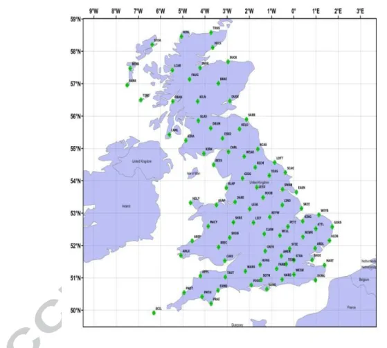
global DD GPS daily solutions created by BIGF was chosen, with the CGNSS station locations illustrated in Figure 2.
Fig. 2 The 100+OSGB CGNSS stations included in BIGF that were used for the assessment of PPP in this study.
Experimental Results: Initial Investigation
An initial investigation was carried out by choosing two OSGB CGNSS stations with continuous records and optimal
24 hour observations recorded each day during the year 2014. The two OSGB CGNSS stations selected were
Amersham (AMER) and Aldeburgh (ALDB) with 350 and 354 days respectively. For each of the three PPP daily
solutions (GPS, GLO and GPS+GLO) and the global DD GPS daily solution, the mean of the daily solution coordinate
7
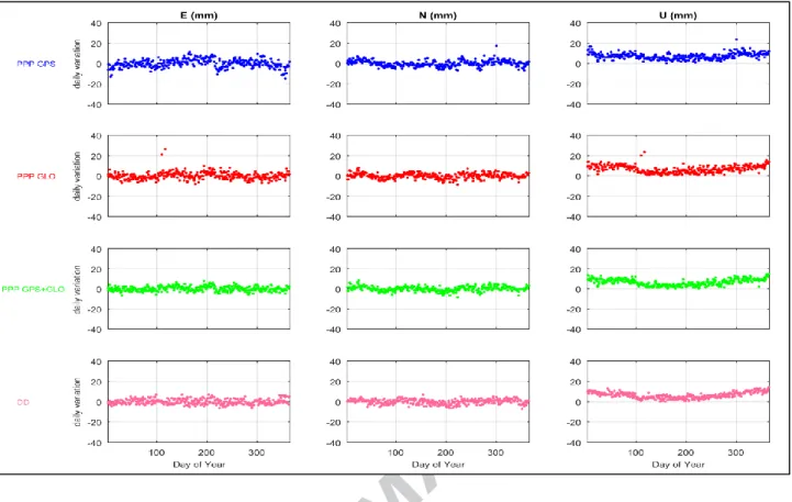
the mean to create daily coordinate differences in terms of Easting, Northing and Up components, as shown in Figure 3
and Figure 4 for ALDB and AMER stations respectively after removing the trend caused by the tectonic plate motion.
Figure 3 and 4 clearly illustrate the stability of the daily solutions as well as the products used for all scenarios, i.e. PPP
(GPS, GLO and GPS+GLO) and global DD GPS. Following this, it was possible to use the daily coordinate differences
in order to calculate the repeatability of the daily solution coordinate estimates in each case in terms of Easting,
Northing and Up components, following (Blewitt, 1989):
(1)
Where n is the number of days processed; is the daily solution estimated coordinate component for day “i”; is the
standard error of the daily solution estimated coordinate component for day “i”; and is the mean of the daily
solution estimated coordinate component.
8
Fig 4 Daily coordinate differences from the mean for one year for the ALDB of 354 days.
Bar charts representing the repeatability of the daily solution coordinate estimates as individual coordinate components
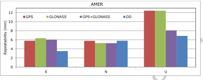
(Easting, Northing, and Up) for the ALDB and AMER CGNSS stations are presented in Figures 5 and 6 respectively.
Fig. 5 Repeatability of the daily solution coordinate estimates from PPP (GPS, GLO and GPS+GLO) and global DD
GPS for ALDB CGNSS station.
0 2 4 6 8 10 12
E N U
Re
p
ea
ta
b
ili
ty
(mm
)
ALDB
9
Fig. 6 Repeatability of the daily solution coordinate estimates from PPP (GPS, GLO and GPS+GLO) and global DD
GPS for AMER CGNSS station.
It can be seen from Figures 5 and 6 that PPP GPS, PPP GLO and PPP GPS+GLO have similar repeatabilities in the
Easting and Northing coordinate components as global DD GPS, and that PPP GPS+GLO has similar repeatability in
the Up coordinate component as global DD GPS. Furthermore, it is clear that PPP GLO has similar repeatbilities to
PPP GPS in all coordinate components.
Experimental Results: Extended Investigation
Following the promising results from the initial investigation, an extended investigation was carried out based on all
100+ OSGB CGNSS stations (see Figure 2) over a 7 week period, as detailed in Table 1. In this extended investigation,
only OSGB CGNSS stations that were continuous for a specific GPS week, had optimal 24 hour observations recorded
each day, and were also present in the global DD daily solutions were included, which led between 56 and 85 OSGB
CGNSS stations per week being available for analysis, as also detailed in Table 1. Bear in mind that the GPS week 1775
stations (56) are the common stations for the 7 weeks.
Table 1 GPS week and the number of OSGB CGNSS stations considered in the analysis for each week
GPS Week No. of CGNSS Stations
1775 56
1776 85
1777 79
1778 74
1783 74
1784 76
1785 79
0 2 4 6 8 10 12
E N U
Re p ea ta b ili ty (mm ) AMER
10
Apart from that, the analysis in terms of repeatability followed a similar approach to the analysis used in the initial
investigation but, in some instances, also considered weekly solution coordinate estimates as opposed to daily solution
coordinate estimates for the stations mentioned in Table 1 with their relevant GPS week. In these instances, for each of
the three PPP daily solutions (GPS, GLO and GPS+GLO) and the global DD GPS daily solution, the mean of the daily
solution coordinate estimates for seven weeks were calculated. The weekly solution coordinate estimates for each week
were then subtracted from the mean to create weekly coordinate differences in terms of Easting, Northing and Up
components. Following this, it was possible to use the weekly coordinate differences in order to calculate the
repeatability of the weekly solution coordinate estimates in each case in terms of Easting, Northing and Up components.
A bar chart representing the RMS of the repeatabilities of the weekly solution coordinate estimates from PPP (GPS,
GLO and GPS+GLO) and global DD GPS as individual coordinate components (Easting, Northing, and Up) for all of
the CGNSS stations considered is presented in Figure 7.
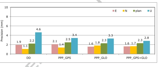
Fig. 7 RMS of the repeatabilities of the weekly solution coordinate estimates from PPP (GPS, GLO and GPS+GLO)
and global DD GPS for all CGNSS stations considered.
As can be seen from Figure 7, the RMS of the repeatabilities of the weekly solution coordinate estimates in terms of
Easting, Northing and Up components respectively is found to be: 2.1, 1.4 and 3.4 mm for PPP GPS; 1.6, 1.8 and 3.3
mm for PPP GLO; 1.6, 1.7 and 2.8 mm, and 1.6, 1.7 and 2.8 mm for PPP GPS+GLO; and 1.9, 1.1 and 4.6 mm for
global DD GPS. Considering PPP GPS and PPP GLO, it can be seen from that the repeatabilities are the same to within
sub-millimetres, which provides an indication of the potential for using PPP GLO as an independent solution to PPP
GPS, rather than simply using GLONASS to aid GPS (PPP GPS+GLO).
In addition to repeatability, it is also possible to estimate any differences between the weekly solution coordinate
estimates from PPP (GPS, GLO and GPS+GLO) and the weekly solution coordinate estimates from global DD GPS. In
1.9 2.1 1.6 1.6
1.1 1.4
1.8 1.7
2.2 2.5 2.3 2.3
4.6
3.4 3.3
2.8 0 2 4 6 8 10
DD PPP_GPS PPP_GLO PPP_GPS+GLO
Pre
cis
ion
(mm
)
11
this regard, measures of accuracy are obtained if the weekly solution coordinate estimates from global DD GPS, which
are independent of the weekly solution coordinate estimates from PPP, are assumed to represent the most probable
values.
A bar chart representing the RMS of the differences between the weekly solution coordinate estimates from PPP (GPS,
GLO and GPS+GLO) and the weekly solution coordinate estimates from global DD GPS as individual coordinate
components (Easting, Northing, and Up) for all of the CGNSS stations considered is presented in Figure 8.
Fig. 8 RMS of the differences between the weekly solution coordinate estimates from PPP (GPS, GLO and GPS+GLO)
and the weekly solution coordinate estimates from global DD GPS for all CGNSS stations considered.
As can be seen from Figure 8, the RMS of the differences between the weekly solution coordinate estimates from PPP
(GPS, GLO and GPS+GLO) and the weekly solution coordinate estimates from global DD GPS in terms of the Easting,
Northing and Up components respectively are found to be: 2.6, 2.5 and 5.5 mm for PPP GPS; 2.1, 4.4 and 8.6 mm for
PPP GLO; and 2.0, 3.3 and 5.5 mm for PPP GPS+GLO, which provides a further indication of the potential for using
PPP GLO as an independent solution to PPP GPS, rather than simply using GLONASS to aid GPS (PPP GPS+GLO).
As a further check, a bar chart representing the RMS of the differences between the daily solution coordinate estimates
from PPP (GPS, GLO and GPS+GLO) and the daily solution coordinate estimates from global DD GPS as individual
coordinate components (Easting, Northing, and Up) for all of the CGNSS stations considered is presented in Figure 9.
2.6
2.1 2.0
2.5 4.4 3.3 3.6 4.9 3.9 5.5 8.6 5.5 0 2 4 6 8 10
PPP_GPS PPP_GLO PPP_GPS+GLO
A cc u rac y (mm )
12
Fig. 9 RMS of the differences between the daily solution coordinate estimates from PPP (GPS, GLO and GPS+GLO)
and the daily solution coordinate estimates from global DD GPS for all CGNSS stations considered.
As can be seen from Figure 9, the RMS of the differences between the daily solution coordinate estimates from PPP
(GPS, GLO and GPS+GLO) and the daily solution coordinate estimates from global DD GPS in terms of the Easting,
Northing and Up components respectively is found to be: 3.6, 3.1 and 7.6 mm for PPP GPS; 3.7, 4.9 and 10.7 mm for
PPP GLO; and 3.8, 4.0 and 7.8 mm for PPP GPS+GLO, which confirms the previous statements made with regards to
the potential for using PPP GLO as an independent solution to PPP GPS, rather than simply using GLONASS to aid
GPS (PPP GPS+GLO).
However, it is clear that the RMS of the differences statistic does not give a complete picture of any biases present, as it
does not consider the fact that these differences can be positive or negative. To overcome this, a bar chart representing
the mean of the differences, or the biases, between the daily solution coordinate estimates from PPP (GPS, GLO and
GPS+GLO) and the daily solution coordinate estimates from global DD GPS as individual coordinate components
(Easting, Northing, and Up) for all of the CGNSS stations considered is presented in Figure 10.
Fig. 10 Mean of the differences, or the biases, between the daily solution coordinate estimates from PPP (GPS, GLO
and GPS+GLO) and the daily solution coordinate estimates from global DD GPS for all CGNSS stations considered.
3.6 3.7 3.8
3.1 4.9 4.0 7.6 10.7 7.8 0 2 4 6 8 10 12
PPP_GPS PPP_GLO PPP_GPS+GLO
D aily V ari ation (mm )
E N U
0.3
-0.6 -0.2
2.0 3.7 2.6 3.2 4.5 3.5 3.2 -5.3 -1.4 -6 -4 -2 0 2 4 6
PPP_GPS PPP_GLO PPP_GPS+GLO
M ea n (m m )
13
It is clear from Figure 10, therefore, that the mean of the differences, or the biases, between the daily solution
coordinate estimates from PPP (GPS, GLO and GPS+GLO) and the daily solution coordinate estimates from global DD
GPS are constellation type dependent. There is also a slight worsening in the Easting and Northing coordinate
components and an obvious worsening in the Up coordinate component for PPP GLO when compared to PPP GPS.
At this stage, it is also worth considering the validity of the assumption that the weekly/daily solution coordinate
estimates from global DD GPS, which are independent of the weekly solution coordinate estimates from PPP (GPS,
GLO and GPS+GLO), are assumed to represent the most probable values. It is clear from Figure 10 that there is a
consistently larger bias in the Northing component than in the Easting component, with the Northing component from
PPP (GPS, GLO and GPS+GLO) being to the north of the Northing component from global DD GPS. One reason for
this could be a reference frame issue, as while the PPP technique relies only on the precise ephemeris products, the DD
technique relies on these but is also affected by the network of global CGNSS stations that were used. Re-considering
Figure 1, which gives an example of the network that was used for the global DD GPS solution on 2014/01/12 (DOY
012 of 2014), the global network contains 97 CGNSS stations to the south of the lowest latitude OSGB CGNSS station
(SCIL, lat = 49.9) but only 19 CGNSS stations to the north of the highest latitude OSGB CGNSS station (KIRW, lat =
58.9).
Furthermore, the subtle differences in the biases for the Northing coordinate component for PPP GLO and PPP GPS
could be a constellation issue related to the higher inclination of the GLONASS satellites when compared to GPS,
which results in a significantly different pattern for the GLONASS and GPS constellations as shown in Figure 11.
Fig. 11 Representative satellite constellation availability (Left: GPS, Right: GLONASS) for ALDB station on DOY 12,
14
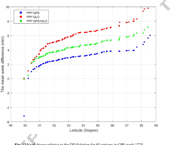
To support that idea, the differences between the mean weekly solution of PPP GPS, PPP GLO and PPP GPS+GLO
were subtracted from the mean weekly solution from the global DD GPS; see Figure 12 for 85 stations in GPS week
1776.
Fig. 12 North biases relative to the DD Solution for 85 stations in GPS week 1775.
It is clear from the Figure 12, that all PPP scenarios’ northing differences have almost the same shape and increasing
differences with the increasing of the station latitude. These increasing differences indicate the effect of the reduced
CGNSS stations to the north for global DD GPS solution. In addition, while PPP GLO has available satellites to the
north, it has larger differences than PPP GPS because of the reduced availability of the GPS constellation with the
increasing of the station latitude. While PPP GPS+GLO will has the balanced differences between both constellations
as shown in Figure 12.
Lastly, considering the biases in the Up coordinate component, it is clear that in the case of PPP GPS+GLO there is
effectively a balancing of the errors present in PPP GPS and PPP GLO. This clearly results in an improvement in the
Up component for PPP GPS+GLO over PPP GLO, as the latter may be more affected by any imperfections in the
15 Conclusions
In this paper, the achievable repeatability and accuracy from PPP daily solutions when using GPS only (PPP GPS),
GLONASS only (PPP GLO), and GPS plus GLONASS (PPP GPS+GLO) for static positioning has been assessed. As
part of the assessment, a comparison with global DD GPS daily solutions has been presented. Based on the RMS of the
repeatabilities of the weekly solution coordinate estimates, and the RMS of the differences between the PPP daily
solution coordinate estimates and the global DD GPS daily solution coordinate estimates, it is shown that all of the PPP
daily solutions can achieve millimetric level repeatability, similar to the global DD GPS solutions. Furthermore, the
mean of the biases between the PPP daily solutions and the global DD GPS daily solutions are constellation type
dependent, while an improvement is found in the Up component for PPP GPS+GLO over PPP GLO, as the latter may
be more affected by any imperfections in the models for GLONASS antenna phase centre variations.
It is concluded, therefore, that PPP GLO daily solutions have the ability to be used as independent solutions to PPP GPS
daily solutions for static positioning, and as an alternative to PPP GPS+GLO or global DD GPS daily solutions.
Acknowledgments: The services of the Natural Environment Research Council (NERC) British Isles continuous
GNSS Facility (BIGF), www.bigf.ac.uk, in providing archived GNSS data and products to this study, are gratefully
acknowledged. Also, the first author acknowledges the financial support he received from his government in Iraq
16 References:
ALCAY, S., INAL, C., YIGIT, C. & YETKIN, M. 2012. Comparing GLONASS-only with GPS-only and hybrid positioning in various length of baselines. Acta Geodaetica et Geophysica Hungarica, 47, 1-12.
ANQUELA, A. B., MARTÍN, A., BERNÉ, J. L. & PADÍN, J. 2013. GPS and GLONASS Static and Kinematic PPP Results. Journal of Surveying Engineering, 139, 47-58.
BLEWITT, G. 1989. Carrier Phase Ambiguity Resolution for the Global Positioning System Applied to Geodetic Baselines up to 2000 Km. Journal of Geophysical Research-Solid Earth and Planets, 94, 10187-10203.
CAI, C. Precise point positioning using dual-frequency GPS and GLONASS measurements. Masters Abstracts International, 2009. CAI, C. & GAO, Y. 2013. Modeling and assessment of combined GPS/GLONASS precise point positioning. Gps Solutions, 17,
223-236.
CHEN, G. & HERRING, T. A. 1997. Effects of atmospheric azimuthal asymmetry on the analysis of space geodetic data. Journal of Geophysical Research-Solid Earth, 102, 20489-20502.
COLLINS, P., BISNATH, S., LAHAYE, F. & HÉROUX, P. 2010. Undifferenced GPS Ambiguity Resolution Using the Decoupled Clock Model and Ambiguity Datum Fixing. Navigation, 57, 123-135.
DACH, R., HUGENTOBLER, U., FRIDEZ, P. & MEINDL, M. 2007a. Bernese GPS software version 5.0 (user manual of the Bernese GPS software version 5.0). AIUB—Astronomical Institute, University of Bern, Switzerland.
DACH, R., HUGENTOBLER, U., FRIDEZ, P. & MEINDL, M. 2007b. Bernese GPS Software Version 5.0. Astronomical Institute, University of Bern. Berne, Switzerland.
FENG, S., OCHIENG, W., MOORE, T., HILL, C. & HIDE, C. 2008. Carrier phase-based integrity monitoring for high-accuracy positioning. GPS Solutions, 13, 13-22.
JOKINEN, A., FENG, S. J., SCHUSTER, W., OCHIENG, W. Y., HIDE, C. D., MOORE, T. & HILL, C. J. 2013a. GLONASS Aided GPS Ambiguity Fixed Precise Point Positioning. Journal of Navigation, 66, 399-416.
JOKINEN, A., FENG, S. J., SCHUSTER, W., OCHIENG, W. Y., YANG, L., MOORE, T. & HILL, C. J. 2013b. Improving ambiguity validation and integrity monitoring of Precise Point Positioning (PPP). Proceedings of the 26th International Technical Meeting of The Satellite Division of the Institute of Navigation (ION GNSS 2013). Nashville, Tennessee. KOUBA, J. 2009. A guide to using International GNSS Service (IGS) products [Online]. Available:
http://igscb.jpl.nasa.gov/igscb/resource/pubs/UsingIGSProductsVer21.pdf.
LARSON, K. M., LOWRY, A. R., KOSTOGLODOV, V., HUTTON, W., SANCHEZ, O., HUDNUT, K. & SUAREZ, G. 2004. Crustal deformation measurements in Guerrero, Mexico. Journal of Geophysical Research-Solid Earth, 109.
LIU, Z. Z. 2011. A new automated cycle slip detection and repair method for a single dual-frequency GPS receiver. Journal of Geodesy, 85, 171-183.
MCCARTHY, D. D. & PETIT, G. 2004. IERS conventions (2003). Germany: DTIC Document.
MEINDL, M., SCHAER, S., HUGENTOBLER, U. & BEUTLER, G. 2004. Tropospheric gradient estimation at CODE: Results from global solutions. Journal of the Meteorological Society of Japan, 82, 331-338.
NIELL, A. E. 1996. Global mapping functions for the atmosphere delay at radio wavelengths. Journal of Geophysical Research-Solid Earth, 101, 3227-3246.
REUSSNER, N. & WANNINGER, L. 2011. GLONASS Inter-frequency Biases and Their Effects on RTK and PPP Carrier-phase Ambiguity Resolution. Proceedings of the 24th International Technical Meeting of the Satellite Division of the Institute of Navigation (Ion Gnss 2011), 712-716.
SAASTAMOINEN, J. 1973. Contributions to the theory of atmospheric refraction. Bulletin Géodésique, 107, 13-34.
WU, J., WU, S., HAJJ, G., BERTIGER, W. & LICHTEN, S. 1993. Effects of antenna orientation on GPS carrier phase. Manuscripta Geodaetica, 18, 91-98.
17 Highlights
Comparison between Precise Point Positioning (PPP) and Global Double Difference (DD).
PPP GLO can reach the Accuracy and the Precision of the Global DD.
PPP has a constellation type biases because of the geometry of the constellation.