MAMIE C2Piin
e
Lentz, Rodrick D. 1994. Soil Zrosion. pp . 345-347. In: McGraw Hill Yearbook
of Science & Technology. ISBN 0-07-051517-4.
McGRAW-HIELL YEARBOOK OF
Science $z
Technology
1994
Comprehensive coverage of recent events and research as compiled by
the staff of the McGraw-Hill Encyclopedia of Science & Technology
McGraw-Hill, Inc.
McGRAW-HILL YEARBOOK OF SCIENCE & TECHNOLOGY
Copyright © 1993 by McGraw-Hill, Inc.
All rights reserved. Printed in the United States of America.
Except as permitted under the United States Copyright Act of 1976,
no part of this publication may be reproduced or distributed in any
form or by any means, or stored in a database or retrieval system,
without prior written permission of the publisher.
1 2 3 4 5 6 7 8 9 0 DOW/DOW 9 9 8 7 6 5 4 3
Library of Congress Cataloging in Publication data
McGraw-Hill yearbook of science and technology.
1962–
. New York, McGraw-Hill Book Co.
v. illus. 26 cm.
Vols. for 1962–
compiled by the staff of the
McGraw-Hill encyclopedia of science and technology.
1. Science—Yearbooks. 2. Technology
Yearbooks. 1. McGraw-Hill encylopedia of
science and technology.
Q1.M13
505.8
62-12028
Soil erosion
345
f Florida Dep. Agr. Bull., 1981; W. R. Nickle Manual of Agricultural Nematology, 1991; W. R.
(ed.), Plant and Insect Nematodes, 1984.
erosion
research in soil erosion has involved the to -'c parameters associated with the ephemeral the effects of wind erosion on cropland and for control, and the use of windbreaks g erosion.
Parameters of Ephemeral Erosion
meral gullies are channels that form in culti-fields when precipitation exceeds soil infiltra-rates. Excess water moves downslope as thin-flow but eventually coalesces into small streams. scouring occurs in these concentrated flows water velocity is greater. Small channels, or subsequently develop on upper slopes; larger s form on lower slopes in concave swales that as surface drains for relatively larger watersheds. larger gullies are called ephemeral gullies when are small enough to permit passage of tillage
nts.
eral channels tend to form in the same loca-each season, primarily because gully location is y controlled by landscape configuration. Unlike channels, tills occur at random locations on lope each season; thus soil is removed from the slope, although the magnitude of erosion varies slope position. Tillage acts as a cut-and-fill pro-extending the impact of the gully several meters
the ephemeral channel on both sides. Repeated of channel formation and tillage-filling remove r volume of topsoil from these areas and can y reduce crop yields. Adjacent slopes become , hastening processes of rill and interrill
ero-actors influencing gully formation are those that e (1) precipitation rates, (2) infiltration and -retaining capacities of the soil, (3) resistivity of it to detachment and transport, and (4) trans-capacity of overland flow. Recent research has ed how landscape topography influences the ce and severity of ephemeral gullies in a given ed. This dependence occurs over a range of
scales.
opography external to watershed.
hic features occurring beyond the watershed influence ephemeral erosion via impacts on of watershed precipitation and temperature ons. The potential for erosion becomes greater ber and intensity of rainstorms increase. Occur-of temperature transitions can increase erosion, arly in early spring when soil frost just below ace prevents infiltration of warm rainwater. thawed surface layer becomes saturated, and soil les are easily dislodged by concentrated flow. regional and local physiography may influenceeral erosion.
Regional influence. At the regional scale, the impact of orography on precipitation patterns is well known. Topographic barriers may decrease cyclonic precipitation on the leeward side, owing to drying as-sociated with descending air. A reverse effect can oc-cur when convectional storms develop over mountains and drift over leeward valleys. (Convectional storms are created when air that is warmed at the Earth's sur-face rises into the cooler upper atmosphere and, upon cooling, forms clouds and precipitation.) For example, a watershed separated from moist, temperate marine air by a mountain barrier will be subject to less severe ephemeral erosion than an identical watershed not so separated. Not only will the number of annual storms be reduced at the drier location, but the climate of the location may also be more continental; winters may be colder, perhaps cold enough that precipitation may fall in frozen form, eliminating the erosion potential in that season entirely.
The position of the watershed with respect to a top-ographic barrier may also determine whether storms are dominantly cyclonic or convectional in character. Rainfall from convectional storms is of higher intensity than that from cyclonic systems. High-intensity rains generally produce more runoff, because higher rates of precipitation commonly exceed capacities for soil in-filtration. In addition, the kinetic energy of larger rain-drops is greater, possibly leading to rapid formation of a surface seal that can reduce infiltration by as much as 80%. Watersheds in convectional rainfall areas may experience erosion throughout the warm season. Even when crop cover reaches its maximum, runoff and erosion may result from convectional storms because of high precipitation rates.
Local Influence. Local features influence rainfall and temperature regimes between different watersheds. Certain landscape configurations can channel airflow, producing zones of low-level moisture convergence. In these zones, a relatively warm, moist airflow col-lides with another ainnass flowing from a different
140
A 130
E
.4. 76. 120
-6 110
100
90
80
70
0 10 18.7 25.5 31.6 37 43.1 49.9 58.6 68.3 horizontal distance, ft
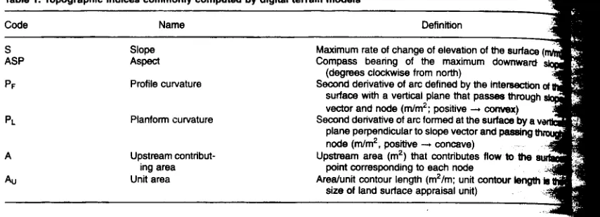
Table 1. Topographic indices commonly computed by digital terrain models
Code Name Definition
S Slope ASP Aspect PF Profile curvature PL Planform curvature A Upstream
contribut-ing area Au Unit area
Maximum rate of change of elevation of the surface Compass bearing of the maximum downward
(degrees clockwise from north)
Second derivative of arc defined by the intersection of surface with a vertical plane that passes through vector and node (m/m2 ; positive convex) Second derivative of arc formed at the surface by a v
plane perpendicular to slope vector and passing th node (rn/m2 , positive concave)
Upstream area (m2 ) that contributes flow to the point corresponding to each node
Area/unit contour length (m2/m; unit contour length le size of land surface appraisal unit)
direction and from a different source area, so that locally higher mean rainfall results. Complex relief is thought to reduce the efficiency with which developing storms assimilate latent energy from the atmosphere. As a result, convectional storm activity in complex physiography consists of numerous small raincells that produce less intense rainfall. In smooth terrain, rain-cells can grow larger and produce more intense pre-cipitation of longer duration. A watershed positioned in depressions or near the lower terminus of canyons or drainages experiences more temperature transitions than one not exposed to drainage of cold air; as a result, incidents of rain on frozen soil increase in the former.
Internal topography of watershed. The
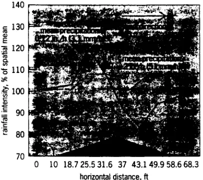
physiography of the watershed itself can affect runoff, and hence ephemeral erosion, by influencing spatial distribution of precipitation and infiltration, and by playing a role in controlling runoff or subsurface flow. Within the watershed, microclimates associated with surfaces of different slope and aspect create vari-able temperature patterns, crop production, and soil properties. Hydrologic response varies accordingly. For example, greater crop or residue cover or greater soil organic matter impedes the formation of surface seals due to raindrop impact; thus infiltration is bet-ter maintained, and runoff is reduced. Evidence indi-cates that interaction between wind and ridge-shaped relief causes unequal distribution of precipitation at the surface. The effect of wind on the pattern of rainfall intensity received over a hill, where rainfall is converted to an equivalent depth received on a level surface is shown in Fig. 1. Thus, the config-uration and orientation of divides or included ridges within watersheds determine surface precipitation puts under a given wind regime, and these inputs in-fluence the location and severity of ephemeral channel development. Internal topography primarily controls ephemeral erosion by determining the distribution of soil moisture in the watershed and the erosive power of emergent streams of concentrated flow. An un-derstanding of these processes is essential in order to evaluate the erosion potential inherent in different landscapes.
Digital terrain models.
In order to examine spa-tially dependent processes in landscapes and tode-velop predictive relationships that are applicable diverse environments, researchers require a nonpo-sitional method of relating spatial properties withi
landscapes. In other words, the location in a land-scape associated with ephemeral gully formation must, not be defined in terms of fixed coordinates, but by parameters that describe erosion potential inher-ent at the location. Because ephemeral erosion pro-cesses are very sensitive to landscape configuration, parameters have been derived from topographic at-tributes.
Topographic parameters describing each location in a watershed are calculated by using a three-dimension-al numericthree-dimension-al representation of the watershed surface, the digital elevation model. Commonly, the digital elevation model is given as a series of elevations (Z values) for X and Y coordinates, as defined by the nodes of a uniform grid. A computer program analyzes the digital elevation model and outputs a digital terrain model; it models surface configuration by using topographic indices computed for surface points corresponding to all nonperipheral grid nodes in the digital elevation model. The indices commonly computed for each grid node are listed in Table 1. The relationship between curvature parameters and surface configuration is illustrated in
Fig. 2.
Predicting ephemeral gullies.
The associations between simple and combination indices and the oc-currence and severity of ephemeral gullies inwater-direction of maximum slope
parameters a
Soil erosion
347
associated indicator or predictive potential
Channel occurrence ' (high soil moisture)
Indicate that the term in the firer Coltmerie derived from and minus signs Indicate the-skid:at thireortalation.
1p may veridependIngi on imitation&
product at the Indices given; that in. PE'A'S Po< Axra. • •
are presented in Table 2. Recent studies have that the presence of ephemeral channels is strongly related to the topographic parameter .nform curvature (the curvature of the Earth's as measured along the contour). Once this is accounted for, indices coded as PFS, LNAS, S (see Table 2) • provide further explanation variability observed with regard to gully posi-in watersheds. The severity, or size of ephemeral
s, was also found to be primarily related to curvature. Secondary relationships with the LNAS, ABS, and CTI have been observed. of the relationships observed between the nce and severity of ephemeral gullies and
to-c parameters appears to differ between wa-having contrasting soil properties or other nces. The suggestion is that one, two, or three phic parameters may not adequately describe ral erosion hazards in various landscapes, and graphic parameters alone are not adequate to the pattern of the erosion that may develop given site. Current approaches used to evaluate hemeral erosion potential in landscapes have yed topographic parameters or have endeavored velop physically based mathematical models. The es of internal topography on the patterns of
temperature transitions, and soil properties
not been addressed in these efforts, and they need Included in future designs. Rodrick D. Lentz
Parameters of Wind Erosion
erosion of soils by wind has always presented a to society. Many human activities can
acceler-s basic geomorphological process, but erosion controlled with some basic practices. Wind
on can render land almost useless for traditional ture. Only the most rudimentary agricultural
can operate in a severely eroded region. In
on to damaging the land, wind erosion degrades vironment by generating large dust clouds that
the Sun, render traffic extremely hazardous, orate painted surfaces, and damage or destroy seedlings and any moving mechanical device. g and using available resources is the key to
effective and efficient control of wind erosion. Soil erosion by wind is a subtle process, but the damage to plants can be dramatic. The impact on the soil may not be apparent until irreparable damage has already been done. Damage to plants is immediately apparent, because plants may be cut off at the soil surface; in addition, plants may be sufficiently dam-aged that the seedlings will die later, or the damage is such that crop quality and yields are severely reduced. Wind erosion has been studied for many years, but only recently have workers begun to understand the complete process and the complexity of trying to ac-curately measure and model wind erosion in the field. To describe the impact of wind erosion on the soil's ability to produce crops will require many years of additional research, because the impact depends on depth of the soil profile, the crop being grown, and the climate.
Effects on soil.
Wind can detach soil particles, roll them along the soil surface, or inject them into the wind stream. Small particles become suspended in the air stream and may be transported hundreds to thou-sands of kilometers. In the detachment and transport process, the fine material is sorted in a manner similar to the winnowing of grain. The finest particles, 2-100 micrometers in diameter, are suspended in the air stream; the intermediate-size particles, 100-500 pm, are bounced along the soil surface in a process known as saltation; and the largest particles, 500-1000 pm, are moved along at the surface in a process known as soil creep.As the soil surface continues to erode, it may be subjected to additional abrasion such that nonerodible aggregates are broken into erodible fractions. The fine material and soil organic matter that is lost represents the most productive portion of the soil profile.
![Anti Reversing Techniques [sonicpj] pdf](data:image/gif;base64,R0lGODlhAQABAIAAAP///wAAACH5BAEAAAAALAAAAAABAAEAAAICRAEAOw==)