473
Copyright © 2011-15. Vandana Publications. All Rights Reserved.
Volume-5, Issue-2, April-2015
International Journal of Engineering and Management Research
Page Number: 473-478
\
Indoor Navigation System using QR Codes
Abhimanyu Gite1, Swapnil Kamble2, Kajal Kumbhar3, Nutan Bankar4, Prof. U. A. Mande5
1, 2, 3, 4
Department of Computer Engineering, Sinhgad College of Engineering, Vadgaon (bk.), Pune, INDIA
5
Associate Professor, Department of Computer Engineering, Sinhgad College of Engineering, Vadgaon (bk.), Pune, INDIA
ABSTRACT
Indoor Navigation System using QR Codes is a system which helps people (who are new in a particular building for which the system is implemented) to navigate easily to their desired destination. The user can see his current location by scanning the QR code corresponding to the particular enclosure. A path will be calculated from current location to selected destination and it will be displayed. This system can be implemented for any infrastructure through the Administrator application that we will provide. Our system provides a cost-effective solution for Indoor Navigation as compared to the various other technologies implemented for this purpose.
Keywords—Navigation, QR-Code.
I.
INTRODUCTION
In today’s world, outdoor navigation has become a piece of cake through the widespread use of the technology GPS (Global Positioning System). But these applications do not cater to the needs of indoor navigation as GPS requires direct line of sight to the satellite. Many attempts have been made towards building indoor navigation systems for various infrastructures. As students, we feel that when new students take admission in a college, they have no idea of “What is where?” inside a building.
The basic idea behind the development of the application is the inconvenience of the user in an unknown infrastructure to find the destination on his own. Thus we propose to build such a system for our college campus buildings, which involves pasting QR codes at some specific locations in a building. This would help for determining current user location by scanning the QR Code and hence navigation inside the building. This can be achieved by storing floor plans of the buildings in our database on the server. This solution proves to be a
cost-effective one as compared to other alternatives like Wi-Fi, RFID tags, Bluetooth assisted GPS etc.
II.
PRIOR APPROACH
Indoor localization deals with finding the location of a particular place in the indoor environment. We know that the GPS technology is prevalent in the outdoors, but it is does not work well indoors. Efforts had been made to overcome this. For example, Assisted GPS, wherein a data server with reference receiver is employed to assist the signals of GPS [1].
Some other technologies include the use of Bluetooth, a short range communication technology. Radio Frequency Identification (RFID) is also another technology that can be used [3]. It involves the use of passive or active RFID tags. In addition, several Wireless fidelity (Wi-Fi) transmitters could be used for having an accurate localization result. Another solution is to use Ultra Wide Band (UWB) signals [4]. This technology uses a wide bandwidth signal.
NFCs/QR Codes could also be used a solution. Near Field Communication (NFC) is a wireless technology for short range communication [5]. NFC tags/QR Codes can be scattered throughout the building with known specified positions, so as to enable the ability in determining the location of a device that scans those tags/QR Codes.
Also there exists an implementation based on QR codes, in which QR Codes are scanned continuously to keep updating the path.
III.
DRAWBACKS IN PRIOR
APPROACHES
474
Copyright © 2011-15. Vandana Publications. All Rights Reserved.
systems.
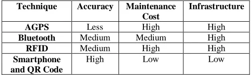
In Assisted GPS, the drawback is that it is not very accurate [1]. The system implemented using Bluetooth has a good accuracy, but the cost of implementation is very high. Talking about RFID, the position accuracy depends on the types of tags, either active or passive, as well as the number of these tags. Existing RFID based Indoor Navigation solutions are generally based on the use of passive RFID tags [2], as active RFID tags are very expensive.
In the system, where Wi-Fi technology is used, several Wi-Fi transmitters are needed to have an accurate localization result [3]. Also, the network strength can vary and this could affect the accuracy of the technique. The Ultra Wide Band (UWB) system could produce accurate results but it is not commonly used as the cost of implementation is very high [4].
Technique Accuracy Maintenance Cost
Infrastructure
AGPS Less High High
Bluetooth Medium Medium High
RFID Medium High High
Smartphone and QR Code
High Low Low
Table 1:
Comparison between various technologies
The last two solutions mentioned i.e. the solution of NFC tags and QR Codes are cost-effective solutions. NFC tags are not much expensive and can be used for this system. The setup time for communication in NFC is very small(less than 0.2 second). But, in the end QR codes prove to be a more cost-effective solution, as it requires almost negligible cost. Also, the generation of required QR codes is very easy. They just need to be generated, printed and pasted at the specific locations. Also the accuracy is guaranteed due to the fixed positions of the QR Codes.
Another implementation in which QR Codes are scanned continuously poses the problem of properly identifying and decoding the QR Codes due to the fast movement of the user. In our system, as we will be implementing a system in which the QR Codes will be pasted at specific locations, we won’t face this problem.
IV.
OUR APPROACH
We have selected the approach of QR Codes for our system as proves to be the most cost-effective solution. Our system would work in the following way:
Figure 1:
The client side application will be used by the people who want to navigate inside the building. In this application, the user first selects the site on which he wants to navigate. If related map images and data are already present in the local database, they do not need to be downloaded. If they are not present, then they need to be downloaded to the device. The Internet would be used only for this download. After this, all further operations can be carried out offline. This is an important feature as one enters the building, the mobile network is not always strong, and hence accessing only local database for further operations solves this problem. Then a map image is displayed on the next screen. Here an option of “Scan QR Code” is provided, wherein the user can scan a particular QR Code and the application will then show him the corresponding location by using a pointer on the map image. A separate option for navigation will be provided. Here, the user needs to provide the source and destination by either scanning respective QR codes or by entering through keyboard. He will then be shown the corresponding path. A list box would be provided where the user will be able to see the list of all rooms for the particular site, and can check their location of map by clicking on it. These operations would be implemented for
Block Diagram
Firstly, the Administrator application is provided for any person who wants to implement the system for his infrastructure. In the Administrator application, the administrator would create a new project site by uploading map images related to the building. He would define the north direction of the building. He would then set the scale by giving a measure of suppose the width of a particular room. Also, he would define the various rooms in the image. Finally, he would define the possible paths between the rooms. All this data will then be passed to the server APIs as JSON objects.
475
Copyright © 2011-15. Vandana Publications. All Rights Reserved.
every floor of the building. The user will be provided with an option to select the floor.
This is how our system would cater Indoor Navigation for the users by the Client Application, who can reach their desired destination on their own not requiring anyone else’s help. Also, the availability of Administrator application ensures that anyone who wants to implement this system can do so.
V.
IMPLEMENTATION
Server:
A Server with static IP-address maintains a Database server. MS SQL server 2012 is used as Database Engine. Web services provide APIs to store map database and to access it. Web-services are developed using visual studio 2012 in C#.
JSON objects are received from administrator app and then parsed to create database entries. There is cross platform communication between Administrator application and WEB services on server. JSON objects are sent from android device and received by web services based on .net framework.
APIs on Server help to read relevant parameters from JSON objects and store them in tables created in server database. Also separate APIs are provided for Downloading map data from database server.
Administrator App:
Administrator app is aimed to adding new sites and all the map data about that site to the database server. Here inputs from administrator are accepted to create JSON objects. Map image is taken from SD-card of device and then all of bytes are converted to string, so that it can be sent in JSON objects. Other relevant data defining rooms, path between two rooms etc. is also sent to server along with map image.
User App:
User app first downloads map image and related data form server using web services provided for the purpose. The downloaded data is stored on local database. It also provides multi-touch view to view map image. A separate class is designed to handle multi-touch view. When user scan the QR-Code of specific location, current position marker indicating user’s location appears on that location. For scanning the QR-Code, external library is imported to the project [6]. Information of path between any two rooms is fetched from database and plotted on map image.
VI.
RESULT
Admin application
Give title of project site
476
Copyright © 2011-15. Vandana Publications. All Rights Reserved.
Select the map image
Set the scale of map
Give the measurement
Set direction of map image
Set direction of map image
477
Copyright © 2011-15. Vandana Publications. All Rights Reserved.
User application
Map is loaded
Scan QR-Code to view user location
Showing user location
478
Copyright © 2011-15. Vandana Publications. All Rights Reserved.
Showing path from selected source to destination
VII.
ACKNOWLEDGEMENT
The Authors would like to acknowledge to the Department of Computer Engineering and to Prof. U. A. Mande for their continuous guidance and support.
VIII. CONCLUSION
Hence this paper discusses various existing approaches and illustrates how indoor navigation system can be implemented using QR-Codes for tracking user’s location. This proves to be the most cost effective way as compared to other approaches. Accuracy of user’s location is guaranteed. Also this system can be implemented for any building using administrator application to upload map image and related data.
REFERENCES
[1] Ozdenizci, Kerem Ok, Vedat Coskun, Mehmet N. Aydin, "Development of an Indoor Navigation System Using NFC Technology", Fourth International Conference on Information and Computing Science (ICIC), pp. 11-14, 2011.
[2] Pierre-Yves Gilliéron, Bertrand Merminod, "Personal Navigation System for Indoor Applications", 11th IAIN World Congress, Berlin, Germany, pp. 21-24, 2003. [3] J. Candy, "A Mobile Indoor Location-Based GIS Application", 5th International Symposium on Mobile Mapping Technologies (MMT07), Padua, Italy, 2007 [4] Sinan Gezici, "Localization via ultra-wideband radios: a look at positioning aspects for future sensor networks",
IEEE Signal Processing Magazine, vol. 22, pp. 70-84, 2005.
[5] Annika Paus, "Near Field Communication in Cell Phones", Technical Report, Bochum Ruhr University, Germany, pp. 1-12, July 2007.
[6] https://github.com/diazaro66/QRCodeReaderView [7] Guillermo Amat, Javier Fernandez, Alvaro Arranz, Angel Ramos, “Using Open Street Maps data and tools for indoor mapping in a Smart City scenario”, Proceedings of the AGILE'2014 International Conference on Geographic Information Science, Castellón, June, 3-6, 2014. ISBN: 978-90-816960-4-3
[8] Ilkovičová, Ľ., Erdélyi, J. and Kopáčik, A., “Positioning in Indoor Environment using QR Codes”, INGEO 2014
[9] Rahul Raj C. P, SeshuBabu Tolety, Catheine Immaculate, ”QR code based navigation system for closed building using smart phones”, 978-1-4673-5090-7/13/$31.00 ©2013 IEEE
[10] José Antonio Puértolas Montañés1, Adriana Mendoza Rodríguez2, Iván Sanz Prieto, “Smart Indoor Positioning/Location and Navigation: A Lightweight Approach”, International Journal of Artificial Intelligence and Interactive Multimedia, Vol. 2, Nº 2. 10.9781/ijimai.2013.225
[11] Omran Al Hammadi, Ahmed Al Hebsi, M. Jamal Zemerly, Jason W.P. Ng, “Indoor Localization and Guidance using Portable Smartphones”, 2012 IEEE/WIC/ACM International Conferences on Web Intelligence and Intelligent Agent Technology.