An integrated GIS and spatial decision support
system for market policy, analysis, research and
development
Sumanta Das
1and Malini Roy Choudhury
21,2
Department of Civil Engineering, Marwadi Education Foundation Group of Institutions (Gujarat Technological University), Rajkot-360003, Gujarat, India
There is always a growing consensus on the necessity of transforming GIS into real decision support tools. In this paper, we recommend the integration of GIS and Multi-criteria analysis methods for Market Policy, Analysis, Research and Development. We present the reasons that have led to this integration and a conceptual framework to facilitate it. It also provides a brief summary of applications and research issues for geo-spatial technologies. The paper summarizes important features, functions, capabilities for geographic technologies and finding out the proper location of new industries on the basis of site suitability analysis and its land and parcel information. It also represents a research and development and management strategy. In addition, business analysis and research topics for GIS have been discussed and analyzed. Opportunities for research are proposed including issues related to GIS management, organizational impacts, utility and facility management, collaborative issues, evaluations of decision-making effectiveness, and societal impacts in both developed and developing countries.
Keywords: GIS, spatial decision support systems, utility and facility management, market applications, business development
INTRODUCTION
During consideration of any location of a facility or of a destination (e.g., the petrol pump at where you will recharge your vehicle fuel tank). Generally, how do you decide about that location? In most cases, people consider the location in relation to the features of relevance that is in proximity to that site. Now, consider the way in which the typical decision support system (DSS) is used for decision making. Certainly a number of relevant criteria are considered in the models and analyses that are processed using these systems. However, in the majority of cases, relevant spatial criteria are inadequately represented in these systems and, for that matter, in most of the information systems that are typically used by organizations and studied by organizational researchers. Of course, spatially enabled decision support technologies such as geographic information systems (GIS) are available and can be used by decision makers to capitalize on the wealth of information that is present in spatial data.
Although GIS have been used for several years in the natural resources, forestry, Land information system and environmental industries, only recently have they begun to be used for a broader array of market policy, business and management functions such as logistics, site, utility and facilities management, decision making, and planning. The fact is that, corporate businesses and public sector organizations have begun to use GIS is not surprising, particularly given the fact that much of the data that organizations typically use include significant spatial components (estimates range between 55% and 80%).
*Corresponding author: Sumanta Das, Department of Civil Engineering, Marwadi Education Foundations’ Group of Institutions, Rajkot-360003, Gujarat, India, E-mail: [email protected]
Because of these and other reasons, an increasing number of businesses have begun to make substantial use of GIS for a variety of routine decision support and analysis applications (e.g., market, societal and demographic analyses). The size of the GIS market - estimated at $1.1 billion in 1995 (Daratech, 1995) and within 2016 it will be growing up over 18.55%. (Market Research Reports, Biz).The survey indicates the importance of this technology as a decision support tool.
In spite of the importance of this technology, too little research has been done to understand the role of this technology in business and market analysis. More than two decades ago business school researchers had recognized the promise and importance of mapping ( Ives, 1982; Takeuchi and Schmidt, 1980). Nevertheless, few business scholars have chosen to follow this stream with the result that researchers from other academic disciplines such as geography, Information technology and computer science have performed the bulk of the research on GIS applications and functionality. Researchers in disciplines such as information systems, marketing, real estate, and management can add a great deal to the existing GIS research literature by applying theories, frameworks, applications, and perspectives from their respective fields of study.
Given this, the purpose of this paper is to provide a brief scenario to GIS in market policy and to propose and discuss a research and development framework for those seeking to study the role of GIS in business and market analysis, decision making and use. To accomplish this, firstly I provide an overview of GIS technology. Following this, a conceptual framework for GIS applications is proposed and examples of representative applications are cited and discussed. Next, prospective research activities for scholars and various researchers from the corporate business community are presented.
Geographic information systems and SDSS
GIS is a tool for linking attribute databases with digital maps. However, GIS is really much more than this simple definition would imply. In fact, several definitions of GIS have been proposed, each of which suggests that GIS is much more than merely an electronic mapping tool, Something that is common to most of these definitions is the notion that GIS not only provide users with an array of tools for managing and linking attribute and spatial data, but they also provide users with advanced modelling functions, tools for design and planning, conceptual and logical approach and advanced imaging capabilities. While many of these capabilities also exist in other types of systems, such as visualization and virtual reality systems, GIS are unique because of their emphasis on providing users with a representation of objects in a
cartographically-accurate spatial system and on supporting analysis and decision making.
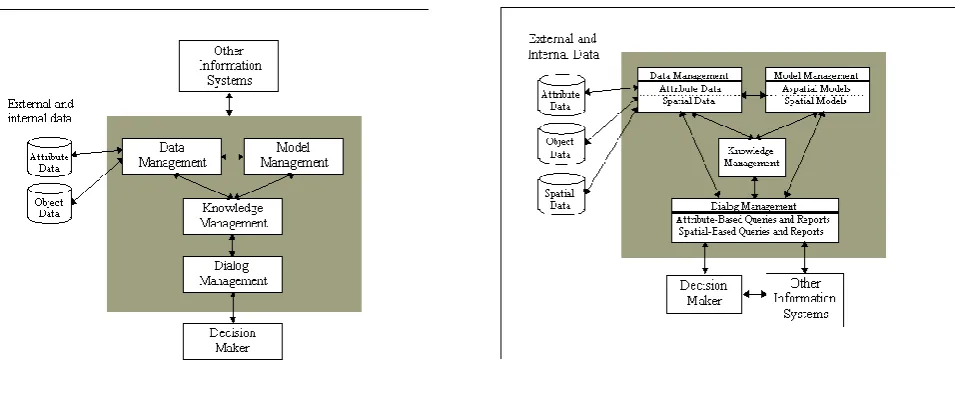
Although data capture, manipulation, and management are important functions of GIS, most GIS are eventually used to support data analysis and decision making. The literature in the management information systems field is rich with descriptions of various decision support technologies that can be applied to GIS. For example, Sprague (1980), Turban (1995), and others have provided useful frameworks for understanding the nature and role of decision support technologies. In particular, the framework proposed by Turban (1995) is quite useful for defining a practical framework for considering GIS (Figure 1). Using such a framework it becomes clear that GIS include all of the features that are in a SDSS; however, they also include several components . For example, a DSS includes various subsystems including data and model management, knowledge management subsystem, and dialog management subsystems. A GIS includes similar subsystems, albeit subsystems which are spatially enabled. For example, a typical non-spatial SDSS will include a data management subsystem designed to manage textual or, in some cases, object-oriented data. A GIS must not only be able to manage these types of data, but also manage and integrate spatial data (e.g., data which include cartographic coordinates).
Similarly, GIS must have a model manager that includes the typical functions, models, and statistical operations present in a SDSS, but it also must provide the user with spatial models and capabilities that can be used to perform variety of spatial modelling and statistical calculations. To help the user manage the complexity involved in integrating these models with attribute and spatial data, several developers have incorporated knowledge management facilities within GIS (Leung and Leung 1993a, 1993b; Skidmore at. al. (1991); Smith and Yiang, 1991; Wu et al. (1988)). Finally, a GIS has a dialog management subsystem that enables users to query and output attribute data, but it also includes spatial and non-spatial query and output capabilities.
Figure 1. A Conceptual Model of a Decision Support System (after Turbin 1995).
Figure 2: A Conceptual Model of a Geographic Information System Used in Decision making
import for researchers, but it also provides a logical framework for guiding developers, managers, and users of this technology. The next section expands on these practical applications by presenting a summary of the important applications of GIS for market analysis and research.
GIS applications in market policy analysis
Market research requires a massive information systems to be generated into database and GIS is a powerful tool which handles the information. Many organizations which is performed by the public sectors that have used geographic information technologies for the last three decades. For example, Landis (1993) suggests that most organizations use information systems for one or more of five applications: transaction processing, operations, inventory control, planning and decision making, and internal management and control. GIS can be used for these functions because this technology possesses capabilities that are common to traditional non-spatial information systems. In addition, GIS also possess characteristics that provide them with capabilities that are not present in other Information systems.
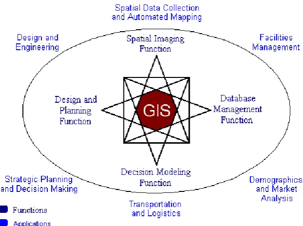
These relationships are portrayed in a conceptual model of GIS (Figure 3) that portrays four GIS functions and related applications. The four functions are derived from four unique activities for which GIS can be used to address the needs of business. The GIS functions are spatial visualization, database management, decision modelling, and design and planning. Spatial imaging refers to the fundamental GIS capability of representing displays of data and information within a spatially-defined coordinate system. The database management function represents the capability of GIS
to store, manipulate, and provide access to data. The decision modelling function represents the capability of GIS to be used to provide support for analysis and decision making. Finally, the design and planning function represents the capability of GIS to be used to create, design, and plan. In addition to these specific functions, the model also represents several specific GIS applications towards which these functions can be applied: spatial data collection and automated mapping, facility management, market analysis, transportation, logistics, strategic planning, decision making, design and engineering. The remainder of this section consists of a discussion of these business applications and how they relate to this model.
Spatial Data Collection and Automated Mapping
Figure 3. GIS Functions and Applications
the definition of an object depends both on the user's purpose for the map (i.e., what objects are to be coded?) and interpretive issues (e.g., is this a tree or a bush?) (Goodchild, 1992). Finally, the training of personnel also represents an important constraint in an organization's ability to capture or create maps. Generally speaking, map production requires knowledge of cartographic, database management, and land surveying principles, principles that many or most business people do not possess (Unwin, 1991). This has often forced the business user of GIS to rely on either commercially generated or government generated data. Although these data are often adequate for many purposes, the scale and accuracy of these maps may not be useful for many business functions (e.g., a large scale map showing the precise location of facilities or equipment in a specific area would likely not be readily available from a vender or consultant).
Although error propagation and training continue as problems, potential opportunities for businesses to make use of AM tools still exist. Remote sensing and global positioning systems (GPS) allow more accurate map production by removing the paper map as a data source (Goodchild, 1992). These advances, combined with improved interpretive tools such as pattern recognition software, mean that a greater number of end users will be able to integrate AM into their routine business activities.
For example, Electric or water utilities probably lead all businesses in their use of automated mapping, having begun early in the 1970s to use commercial GIS technology. Utilities like South Carolina Electric and Gas, B.C. Hydro, Alabama Power, Wisconsin Electric
Power, and Southern California Edison use GIS technology to perform automated mapping. Northern States Power, which provides electric and gas services across five Midwestern states, uses GIS integrated with other corporate systems for automated mapping, managing facilities data and customer records, and other activities such as order processing and network analysis.
Organizations in the petroleum sector have some of the largest automated mapping operations in the world. For example, Chevron, Shell Oil, ONGC, OIL India, Reliance and Union Pacific Resources have adopted GIS and digital image processing for supporting their operational and exploratory activities (e.g., managing well locations, lease information, seismic information and other kinds of data). Similarly, Petroleum Information, a firm which provides mapped information for the oil industry, has more than two million well locations that it has captured and stored in its database. Other natural resource industries likewise use GIS for automated mapping. These include the mining industry, represented by companies like Independence Mining, and firms working with groundwater and environmental management, such as
Ground Water Systems.
street and highway traffic patterns, can be used to perform accurate demographic analysis of neighbourhoods surrounding the billboards.
As with many technologies, automated mapping applications have begun to appear on the Internet. Many of these tools are designed for entertainment and other casual applications. However, a number of organizations have used automated map making for practical applications. For example, Visa Plus has used this service to develop an ATM Locator Service that allows a customer to locate the three nearest ATM machines to a specified street address or intersection.
Facility Management
GIS have been used extensively for facilities management (FM) in the public sector and have great potential for use in the private sector as well. Utility firms, for example, represent one of the largest private-sector GIS end-user groups. In her review of utility applications of GIS technology, Rector, (1993) notes that GIS fulfills "an ever-increasing demand for information pertaining to the location, condition, and performance of the utilities' infrastructure" (p. 193). These information requirements are not limited to utilities since many organizations must manage and control facilities such as manufacturing plants, distribution centres, retail outlets, and other components of the organization's portfolio of physical assets. FM provides managers with a powerful tool for supporting real-time monitoring of facilities and is routinely used for emergency management, security,
and other applications.
The key functions of GIS used in FM are the spatial visualization and database management functions. In other words, most FM applications use historical or transaction (real-time) data to manage or monitor facilities. They also rely heavily on the imaging capabilities of GIS to represent the spatial arrangement of data elements. The AM function of GIS are often combined with FM functions to provide organizations with a system for generating, managing, and utilizing maps and other spatial data that can be used to manage an organization's physical plant (i.e., AM/FM Systems).
Utilities, as mentioned earlier, use GIS for automated mapping; they also make extensive use of GIS for facilities management. These utilities include those mentioned earlier, as well as Boston Edison, Bell South, Consolidated Natural Gas, Kentucky Utilities, and many others (Montgomery, 1995). For example, Pennsylvania Power and Light has located more than two million utility poles using geographic information technology. Boston Gas has created an Automated Mains Management System project which integrates thousands of maps of their distribution system and other information such as leak histories, soil conditions, and construction activity. Wisconsin Electric Power
Company is providing a Work Management System, Electronic Map Access, and a Distribution Dispatch Operating System using GIS technology to service its customers.
Demographic and Market Analysis
Marketing represents the business application for GIS that has enjoyed the most growth in recent years. The primary function of market analysis is to understand the marketplace; in other words, "market analysis means using customer information to estimate the size and character of a market" (Francese and Pirto, 1990). GIS is a powerful market analysis tool because it provides a platform for representing the spatial relationship between the components of the market; that is, the customers, suppliers, and competitors. This has become all the more important as greater competition has forced many firms to find new ways to manage their relationships with customers. Strategies such as target marketing, micro-marketing, and relationship marketing all require that firms capture and maintain detailed information about their customers (Webster, 1994). The ultimate goal of all of these efforts is usually to bring a product or service to someone, somewhere; thus, an understanding of the geo-demographic characteristics of the firm's customers is critical to a
successful marketing strategy.
While all four of the GIS functions shown in Figure 1 are used in market analysis to one degree or another, the key GIS functions used are the database management and decision modelling functions. In most cases, market analysis applications use historical or transaction (real-time) data in combination with decision modelling and support tools to analyze the organization's marketing environment. Furthermore, GIS is a powerful tool in market analyses because it also provides a way to bring together data from multiple sources and link them based on spatial attributes. This often involves a process of layering different types of data on the same map projection so that the decision maker can identify and visualize how data intersect and interact. Thus, GIS is a useful and unique query tool for accessing and displaying components of a database based on the data's spatial characteristics.
of GIS for a wide variety of marketing and operational applications.
Levi Strauss and Co., a leader in the casual apparel market, uses GIS for a broad spectrum of marketing applications. For example, they use geographic technologies to customize their regional advertising and promotions; to select billboards based on location, traffic patterns, and visibility; to select and customize the content of billboards and other local advertisements based on regional demographics; and to customize advertising associated with special-events promotions. GIS is also used to support national promotional efforts, such as new product launches, target marketing, custom mailings, advertising, and media selection (Mennecke et al. (1997)). Many car manufacturers such as the Ford, Toyota, BMW etc. are also using GIS in a broad spectrum of activities. For example, these firms not only use GIS for internal market analyses but also to assist their dealers in analyzing their local markets (Hoerning, 1996; Mennecke et al.(1997)). In this way these firms are vertically integrating GIS and multi-criteria decision support system into their operations with the result that both their direct customer, the dealerships, and their ultimate customer, the consumer and benefit.
Strategic Planning and Decision Making
Strategic decision making generally involves decisions that are broad in scope, unstructured, and focused on long time frames. Information systems that have been developed to support managers in strategic decision making have generally been designed to provide access to data, analytic and modelling tools, and communication support. These tools include management information systems, decision support systems, and executive information systems. The purpose of these information systems is not only to automate the decision-making process but also to support decision makers by providing analysis and modelling tools that can be used to address semi-structured and unsemi-structured problems. Nevertheless, each of these systems, as currently implemented in most organizations, inadequately represents spatial data and information (Densham, 1991). The term spatial decision support system (SDSS) has been proposed to represent easy-to-use systems which incorporate capabilities for manipulating and analyzing spatial data (Cooke, 1992; Densham, 1991; Crossland et al. (1995), Densham, 1991) indicates that an SDSS provides capabilities to input and output spatial data and information. They allow the representation of complex spatial structures, and they include analytical tools for spatial, geographical, and statistical analyses. As such, SDSS are an important class of GIS designed for use by middle and upper-level managers.
Corporate downsizing, organizational restructuring, site selection, and competitive analyses each represent practical areas where GIS can be effectively applied to
strategic endeavors (Juhl, 1994). Several organizations use GIS to support strategic decision making. Prominent among such companies are the international oil companies, many of which have used GIS for several decades.
GIS research opportunities and trends
Although geographic information technologies have existed for several decades, much research needs to be completed, particularly research examining issues associated with the development, implementation, and use of this technology in business settings. One reason for this is that GIS have traditionally been developed, operated, and researched by people with ties, in one way or another, to geography and computer science. This has naturally led to a greater research focus on the technical and cartographic principles related to capturing, representing, and displaying spatial data (Onsrud and Pinto, 1991). As GIS have spread into other areas such as biology, forestry, geology, and similar scientific disciplines, research has similarly tended to focus on technical concerns associated with each of these disciplines. Although the literature on GIS from these areas is rich, great potential exists for researchers from business and information systems to contribute to this stream of research. For example, although some important work on the management of GIS has been published recently (Campbell and Masser, 1996; Huxhold and Levinsohn, 1995; Obermeyer and Pinto, 1994), much more research is needed to better understand issues such as how GIS should be managed in a market setting, the types of market problems it should be used for, how it compares to other types of information systems, and its overall effectiveness as a decision-making tool (Aangeenbrug, 1991; Crossland et al. (1995); Campbell and Masser, 1996).
To address these issues, this section presents a discussion of several important areas in which business school researchers can focus their endeavors. To provide a framework for GIS research, the model shown in Figure 4. The research framework has three main components. First, research topics related to the implementation of GIS are presented. Next, research associated with managing and using GIS are defined and discussed. Finally, the potential impacts of GIS on the organization and on society as a whole are discussed.
Implementation of GIS
Figure 4. Conceptual GIS research framework for market applications
private sector, little has been done to examine GIS adoption and diffusion (Campbell and Masser, 1996) for an excellent review of several case studies of GIS adoption in the public sector), the GIS development process (Clarke, 1991), and cost/benefit tradeoffs (Rhind et al. (1991); Smith and Tomlinson, 1992; Obermeyer and Pinto, 1994). This is not to say, however, that these issues have not been examined for GIS because a number of excellent studies have examined many of these issues in public-sector organizations (Obermeyer and Pinto, 1994; Huxhold and Levinsohn, 1995; Campbell and Masser, 1996).
The business literature documents a variety of experiences with the diffusion and implementation of new information systems innovations that can be applied to GIS research (Kwon and Zmud, 1987). For instance, several researchers have examined technological implementation across several organizations using both surveys and anecdotal case studies. In general, a common theme running through several of these studies is the assumption that diffusion occurs as a multistage process (Rogers 1983; Cooper and Zmud, 1990) and that both behavioural and organizational factors are likely to have important impacts on the success of the implementation (Kozar, 1989; Kwon and Zmud, 1987; Leonard-Barton, 1987; Leonard-Barton and DeSchamps, 1988; Zmud, 1982; 1984). To date, no systematic, theoretically grounded study of GIS implementation across multiple private-sector organizations has been published.
Much also needs to be learned about how GIS differs from other information technologies in terms of user
acceptance. User acceptance, and therefore system success, will likely be influenced by the user's knowledge of GIS as well as their level of training. GIS differ from other information systems in that the underlying technologies are based on geographic and cartographic principles - principles which are likely to be foreign to many end users. In general, people tend to mistrust what they do not understand. Therefore, a lack of knowledge about the underlying principles of cartography could have negative impacts on user acceptance. In some respects, this relationship is similar to the problems faced by users of production and logistics systems in that many end-users often are not equipped to fully understand the principles on which these systems are based. The solution in many business schools has been to include courses on operations research within the distribution requirements. Thus, an examination of pedagogical issues associated with education in GIS principles and geographic analysis in business schools and other academic units is needed (Aangeenbrug, 1991; Rhind et al. (1991)).
CONCLUSIONS AND RECOMMENDATIONS
describe their customers. The process of defining and extending organizational knowledge about customers - which includes providing necessary process improvements and tools to actually sense, describe, and respond to customers - can be significantly enabled by geographic technologies. GIS is useful for managing databases, even extremely large applications such as data warehouses, because it provides an enhanced data structure that is based on the natural organization that geography provides. In other words, data can be organized in a spatial order; the very same organizational order that is used by most managers when they think about their operations and markets. Today, GIS-based data sources vary from satellite imagery used to validate the number of new houses in a retail-market to the individual people-point data of the consumers living in those houses. Data such as these can add significant value to an organization's database by helping to validate and extend their own proprietary resources.
Because of these and other reasons, GIS is moving quickly into the private sector, yet few members of the business research community have actively examined this technology to date. As this paper has attempted to show, many opportunities exist for research on market applications for geographic technologies. For example, more information about managing GIS through the implementation and operational phases of its life-cycle is needed. In addition, research needs to examine issues related to organizational impacts of GIS, collaborative issues, decision-making effectiveness, and factors affecting human perception and cognition. Finally, much needs to be done to examine the societal impacts of GIS in both developed and developing countries. As GIS continues to diffuse into the private sector, researchers should be ready to contribute their expertise to generating a better understanding this technology and its role in managing and operating business organizations.
ACKNOWLEDGEMENTS
We express our gratefulness to the Economic times, Business Geographics for publishing such kind of interesting and informative articles on economic and business development of the nations. We are also thankful to Mr. Sachikanta Nanda (Asst. Professor, Dept. of RS and GIS, SRM University, Kattankulathur) for his endless support and valuable information through out the research. Our gratitude also goes to the entire team of Departments of Civil Engineering, MEFGI (Gujarat Technological University) and the central library of MEFGI for helping us to obtain current market information.
REFERENCES
Aangeenbrug RT (1991). A Critique of GIS. In. Geographic Information Systems Principles and Applications, 1: 101-107.
Abrams ME (1994). Valuing Privacy in the Information Age, GeoInfo Systems, 4(6): 26-28.
Battista C (1994). Billboard Companies Drop Pushpins for Geographic Technologies, Business Geographics, 2(3) 34-35.
Carter JR (1989). On Defining the Geographic Information System, In W. J. Ripple (ed.), Fundamentals of Geographic Information Systems: A Compendium. Falls Church, VA, ASPRS/ACSM, pp. 3-7.
Cheu D (1994). Serving the Client Better with Client Server Business Geographics, Business Geographics, 2:2, pp. 32-33.
Choy M, Kwan MP, Leong HV (1994). On Real-Time Distributed Geographic Database Systems, Proceedings of the Hawaii International Conference on System Sciences, Vol. IV, January, 1994, Los Alamitos, CA: IEEE Society Press, pp. 337-346. Chrisman NR (1991). The Error Component in Spatial
Data In, Geographic Information Systems: Principles and Applications, London: Longman Scientific and Technical, 1: 165-174.
Clarke AL (1991). GIS Specification, Evaluation and Implementation. In, Geographic Information Systems: Principles and Applications, London: Longman Scientific and Technical, 1: 477-488.
Cooper RB, Zmud RW (1990). Information Technology Implementation Research: A Technological Diffusion Approach, Management Science, 36:2, pp. 123-139. Coppock JT, Rhind DW (1991). The History of GIS,
In, Geographic Information Systems: Principles and Applications, London: Longman Scientific and Technical, 1: 21-43.
Cowen DJ (1988). GIS Versus CAD Versus DBMS, Photogrammetric Engineering and Remote Sensing, 54(11): 1551-1554.
Crossland MD, Perkins WC, Wynne BE (1995). Spatial Decision Support Systems: An Overview of Technology and a Test of Efficacy, Decision Support Systems, 14: 219-235.
Crossland MD, Scudder JN, Herschel RL, Wynne BE (1993). Measuring the Relationships of Task and Cognitive Style Factors and Their Effects On Individual Decision-Making Effectiveness Using a Geographic Information System, Proceedings of the Hawaii International Conference on System Sciences, Los Alamitos, CA: IEEE Society Press, 4: 575-584. .
Davenport TH, Eccles RG, Prusak L (1992). Information Politics, Sloan Management Review, 45: 53-65.
Demers MN, Fisher PF (1991). Comparative Evolution of Statewide Geographic Information Systems in Ohio, International Journal of Geographical Information Systems, 5(4): 469-485.
Densham PJ (1991). Spatial Decision Support Systems, In: Geographic Information Systems: Principles and Applications, London, Longman Scientific and Technical, 1: 403-412.
Dueker KJ (1979). Land Resource Information Systems: A Review of Fifteen Years Experience, Geo-Processing, 1, pp. 105-128.
Epstein EF (1991). Legal Aspects of GIS. In: Geographic Information Systems: Principles and Applications, London: Longman Scientific and Technical, Vol. 1, pp. 489-502.
Goodchild MF (1992). Geographical Information Science, Int. J. Geogr. Info. Sys., 6:1, pp. 31-45. Grabowski M, Sanborn S (1992). Knowledge
Representation and Reasoning in a Real-Time Operational Control System: The Shipboard Piloting Expert System (SPES), Decision Sciences, 23, pp. 1277-1296.
Healey RG (1991). Database Management Systems. In: Geographic Information Systems: Principles and Applications, London: Longman Scientific and Technical, Vol. 1, pp. 251-267.
Hearnshaw HM (1993). Learning to Use a GIS. In: Human Factors in Geographical Information Systems, London, UK: Belhaven Press, pp. 70-80. Hoerning R (1996). American Honda Jump-Starts Sales
Geographically, Business Geographics, 4:3, pp. 24-26.
Huxhold WE, Levinsohn AG (1995). Managing Geographic Information System Projects, Oxford, UK, Oxford University Press, pp. 64-71
Juhl GM (1994). Reengineering the Enterprise:
Reaping the Technology Payoff of
AM/FM/GIS, GeoInfo Systems, 4(1) 32-39.
Koshkariov AV, Tikunov VS, Trofimov AM (1989). The Current State and the Main Trends in the Development of Geographical Information Systems in the USSR, Int. J. Geogr. Info. Sys., 3(3): 257-272. Kozar KA (1989). Adopting Systems Development
Methods, An Exploratory Study, Journal of Management Information Systems, 5:4, pp. 73-86. Kunze EA (1993). GIS Delivers Logistics Solutions to
UPS, Business Geographics, 1(4): 34-37.
Kwon TH, Zmud RW (1987). Unifying the Fragmented Models of Information Systems Implementation. In: Critical Issues in Information Systems Research, New York, NY: John Wiley and Sons Inc., pp. 227-251.
Landis JD (1993). GIS Capabilities, Uses, and Organizational Issues. In: Profiting From A Geographic Information System, Fort Collins, CO: GIS World Inc., pp. 23-53.
Lang L (1996b). Beyond the Gas Pump, Business Geographics, (46) 26-30.
Lapalme G, Rousseau JM, Chapleau S, Cormier M, Cossette P, Roy S (1992). GeoRoute: A Geographic Information System for Transportation Applications, Communications of the ACM, 35:1, pp. 80-94.
Leonard-Barton D, DeSchamps I (1988). Managerial Influence in the Implementation of New Technology, Management Science, 34(10): 1252-1265.
Leung Y, Leung KS (1993a). An Intelligent Expert System Shell for Knowledge-Based Geographical
Information Systems, Int. J. Geogr. Info. Sys., 7(1): 189-200.
Maguire DJ (1991). An Overview and Definition of GIS, In: Geographic Information Systems: Principles and Applications, London: Longman Scientific and Technical, 1: 9-20.
Malczewski J (1996). A GIS-Based Approach to Multiple Criteria Group Decision-Making, Int. J.
Geogr. Info. Sys., 10(8) 955-971.
Mark DM (1993). Human Spatial Cognition, In: Human Factors in Geographical Information Systems, London, UK: Belhaven Press, pp. 51-60.
Markus ML, Robey D (1988). Information Technology and Organizational Change: Causal Structure in Theory and Research, Management Science, 34: 583-598.
Montgomery GE (1995). What Really Drives GIS Procurement in Utilities, GIS World, 8(7): 74.
Moore GC (1993). Implications From MIS Research for the Study of GIS Diffusion: Some Initial Evidence. In: Diffusion and Use of Geographic Information Technologies, Dordrecht, Netherlands, Kluwer Academic Publishers, pp. 77-94.
Nagasundaram M (1993). Cognitive Mapping for Better Group Decisions, Groupware Report, 2(5) 6-7. Nunamaker Jr, Dennis JF, Valacich AR, Vogel
DR (1991). Information Technology for Negotiating Groups: Generating Options for Mutual Gain. Management Science, 37(10): 1325-1346. Nyerges TL (1993). How Do People Use Geographical
Information Systems, In: Human Factors in Geographical Information Systems, London, UK: Belhaven Press, pp. 37-50.
Onsrud HJ, Pinto JK (1991). Diffusion of Geographic Information Innovations, Int. J. Geogr. Info. Sys., 5(4) 447-467.
Openshaw S (1991). A Spatial Analysis Research Agenda, In: Handling Geographic Information, New York, NY: John Wiley and Sons Inc, pp. 18-37. Ozemoy VM, Smith DR, and Sicherman A (1981).
Evaluating Computerized Geographic Information Systems Using Decision Analysis, Interfaces, 11, pp. 92-98.
Parker HD (1988). The Unique Qualities of a
Geographic Information System: A
Commentary, Photogrammetric Engineering and Remote Sensing, 54:11, pp. 1547-1549.
Peuquet DJ, Bacastow T (1991). Organizational Issues in the Development of Geographic Information Systems: A Case Study Of U.S. Army Topographic Information Automation, Int. J. Geogr. Info. Sys., 5:3, pp. 303-319.
Raper JF (1991). User Interfaces, In: Handling Geographic Information, New York, NY: John Wiley and Sons Inc., pp. 102-114.
Rector JM (1993). Utilities in Profiting From a Geographic Information System, Fort Collins, CO: GIS World Inc., pp. 193-208.
Rhind DW, Goodchild MF, Maguire DJ (1991). Epilogue, In: Geographic Information Systems: Principles and Applications, London: Longman Scientific and Technical, 2: 313-327.
Sherwood Bryan N (1994). Marks and Spencer Maps It Out, Business Geographics, 2:3, pp. 36-37.
Skidmore AK, Ryan PJ, Dawes W, Short D, O'Loughlin E (1991). Use of an Expert System to Map Forest Soils from a Geographical Information Systems, J.
Geogr. Info. Sys., 5(4): 431-446.
Smith DA, Tomlinson RF (1992). Accessing Costs and Benefits of Geographical Information Systems: Methodological and Implementation Issues, J. Geogr.
Info. Sys., 6(3): 247-256.
Smith TR, Menon S, Starr J, Estes J (1987). Requirements and Principles for the Implementation and Construction of Large-Scale Geographic Information Systems, J. Geogr. Info. Sys., 1(1): 13-31.
Sprague RH (1980). A Framework for the Development of Decision Support Systems, Management Information Systems Quarterly, 4: 1-26.
Taylor DRF(1991). GIS and Developing Nations, In: Geographic Information Systems: Principles and Applications, London: Longman Scientific and Technical, 2: 71-84.
Turk A (1993). The Relevance of Human Factors to Geographical Information Systems. In: Human Factors in Geographical Information Systems, London, UK: Belhaven Press, pp. 15-31.
Unwin DJ (1991). The Academic Setting of GIS, In: Geographic Information Systems: Principles and Applications, London: Longman Scientific and Technical, 1: 81-90.
Vaidya AG, Lang L (1994). When Information is Everyone's Business: ConRail Opens Information Access and Use by Linking Geographic Data, Business Geographics, 2(2): 24-26.
Webster FE (1994). Defining the New Marketing Concept, Marketing Management, 2(4): 23-31. Wendelken S (1994). Lights Up Sales with The
Source, Business Geographics, 2(7): 22-25.
Wu JK, Chen T, Yang L (1988). QPF: A Versatile Query Language for Knowledge-Based Geographical Information Systems, International Journal of Geographical Information Systems, 3(1): 51-58. Zmud RW (1982). Diffusion of Modern Software
Practices: Influence of Centralization and Formalization, Management Science, 28(12): 1421-1431.
Accepted 08 June, 2014.
Citation: Das S, Choudhury MR (2014). An Integrated GIS and Spatial Decision Support System for Market policy, Analysis, Research and Development. International Journal of Geography and Regional Planning 1(1): 002-010.