Volume 4 • Issue 1 • January 2018
ISSN 2206-4451
www.ajbssit.net.au
Integrated Public Transport Information System Using
Android Application
Fujaila Shahnaj, Md. Kamrul Hossain Patwary, Anik Dhar, Bablu Das and Shafiqul Islam Tuhin
Department of CSE, Port City International University, Bangladesh
1. Introduction
Public transportation system plays an important role in the daily life of limpid people at Chittagong city in Bangladesh. It has an enormous effect on the socioeconomic development of a country. Chittagong city has grown rapidly in terms of trade and population growth. Therefore, the need of transportation has increased significantly. The number of private cars is likely to grow further given that currently only 7% of Chittagong city’s commuters own one car according to the data of Bangladesh Road and Transport Authority (BRTA). However, the remaining portion use public transport for their daily transportation to reach their destinations.
An individual who wants to travel from one place to another, who belongs to the majority of the total population, still prefers public transport that is the bus service to reach the destination. A traveler who itinerates a new city finds it very tough to access information about bus routes, their schedules, and fare. Besides, a regular commuter in the city has to wait infinitely for the arrival of the bus in the stops. That is the reason an efficient system should be implemented which is affordable, easy, and reliable for both new traveler and regular commuter. This paper limns an integrated transportation system which acts as a mentor for both the commuter and traveler. This system works with the data about the current location of the user, bus stops, real-time bus locations, timetables, fare, and information about seat status of the bus of the desired destination, bus routes, and also the fastest bus route for any new or regular commuter from any bus stop at Chittagong City. On the other side, the number of Android device users are increasing rapidly in Bangladesh. Over the past few years, the smartphone has changed the handset user dynamics. Nowadays, Nowadays, most new android version handset sale is going to use in different branded Android device. That is why, we choose Android platform to implement the system through Android application.
2. Literature Survey
Android device users are increasing rapidly. People all over the world are facing multifaceted problem in daily transportation. They solve their problems differently developing a system that may be partially or
Abstract
The motto of this paper is to design an integrated public transport information system to guide an individual efficiently who travels using public transport in Chittagong city. It will provide real-time information of the availability of buses, their seat availability, their fares, and their current locations. We used crowdsourcing concept for getting information about buses with the help of an Android-based smartphone. We designed a cloud service to integrate the collected information and process them to provide the users’ real-time information that will make their everyday journey much easier.
24
fully helpful to their region or country. A bus locator through SMS using Android application proposed by Punjabi et al. (2014) updates the details and maintains all the information where mobile phone acts as a Global Positioning System (GPS) receiver. In this paper, it has been mentioned that the current location of the bus for specific pick up point is sent to the server through application. This prolix system updates all the information about every stop. After that, registered students get an SMS from the server side about the next pick up point and also get SMS alert about college-related information such as university news, results, attendance, campus drive, and any other activities. Real-time bus monitoring system using GPS by Chhaa et al. (2013) depicts the locations of the bus in Mumbai city. There is an installed transmitter set on the buses, receiver boards on the bus stops in this system. The relevant bus routes and bus number from source to destination are included in the system. The system shows the bus routes and bus numbers continuously as soon as bus comes within the range of the receiver. Hence, it is easy for pedestrians of the city who can view the bus only after coming to bus stops and no information of the bus can be viewed from other places.
3. Implementation of Internet of Things in Bus Transport System of Singapore
Menon et al. (2013) proposed a system where Internet of Things infrastructure can be used to predict the arrival timings of buses. For communicating between the devices, protocols are used manageably. The architecture proposed by the research would establish a connection between the bus and its information and the passenger through the means of sensors to calculate the empty seating capacity of a particular bus.
Embedded devices were used to collect the temporal information, geographic location, and how fast the bus is moving. They actually conclude saying that bus transportation improves in a number of parameters including management of time, efficiency management, crowd management, and in the number of options being offered to users. We can check the status of bus online using Android devices and application. Patil et al. (2016) designed a database for driver and admin. When driver starts the journey by clicking on the installed apps in his/her mobile, it will auto update the location of the bus. On the other side, public users get the information automatically using mobile application. However, their designed system is not fit for a new traveler who is new to the city and there is no information about seat status that a commuter will able or not to board in the bus as proposed by Patil et al. (2016) and Tejas et al. (2015). The BRTA and Chittagong Development Authority (CDA) have designed their plan for public transportation system. Figure 1 depicts the authentic data provided by the BRTA of fare in the Chittagong city. This depicts the fare list of route No. 4 of Chittagong city.
4. Proposed Methodology
3.1. System architecture
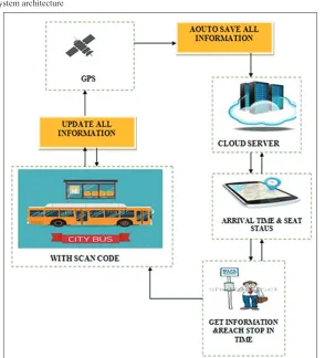
In the system architecture of this application, we have shown how the system actually demonstrates. It depicts the overall working process of synchronization among mobile application, cloud server and GPS, and Google Map service. The architecture of the system is shown in Figure 2.
3.2. Logic design
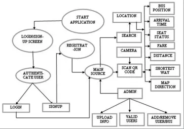
Using the collected data from BRTA, CDA analysis for making an affordable system to process all the data accumulatively, logical design is mandatory task before implementation, logical design is a mandatory task before implementation. Hence, that is why, we have limned the task with data flow diagram in Figure 3 and workflow diagram in Figure 4. According to these two flow diagrams, we implement our application with a high fidelity.
Figure 1: Fare of route-4 public transport
26
driver can easily monitor the location of the intended commuter. The information will be auto updated when users scan the Quick Response (QR) code in the bus using crowdsourcing technique as proposed by Menon et al. (2013) and Tejas et al. (2015). It is also applicable for a new traveler in Chittagong City. This application helps him/her with all information about the route he/she intends to go. Then, he/ she can easily catch the bus.
4. System Implementation
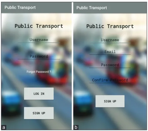
Figure 5 shows the starting page of the application developed for the proposed system. A new user has to register with email address, and after that he/she can login using the email and password.
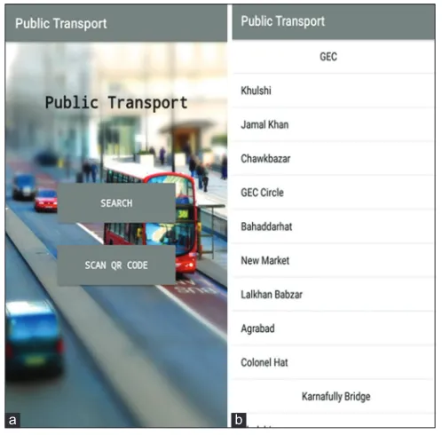
After logging in, there shows the main interface of our application as shown in Figure 6. It presents two options to the user, one for searching a bus on specific route and the other option is for scanning QR code located in the bus.
Figure 6 also shows a page with search option. In the main interface page, if user selects the search option, this page appears. This suggests the user some destinations based on the user’s current location. The suggestions in Figure 6 indicate that the user is now on place called GEC circle, and the application shows him/her some destinations from the GEC circle.
Figure 7 shows that, after user chooses a destination, the application shows him/her the information about destination route and nearest bus. For example, it shows fare, distance, bus registration number, seat capacity, number of vacant seats, possible arrival time, etc.
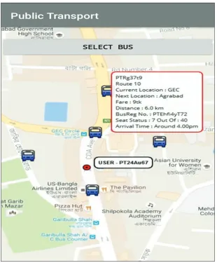
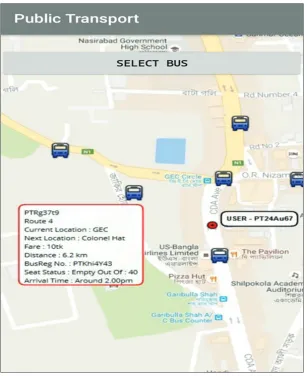
Figures 8 and 9 show that a user can choose a bus from map and then can see detailed information about the bus. For example, arrival time, seat availability, distance, fare, next stoppage, and current location. The map will show all the buses that are running on the route chosen by the user. And if user taps any of the buses, a popup menu will show the details.
Figure 4: Workflow diagram
Figure 5: (a and b) Starting page of the application
28
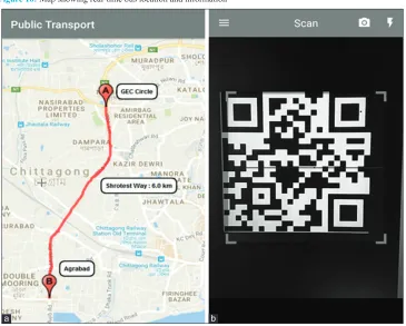
Figure 10 shows the application that provides the shortest path between source and destination location of the user on map. The second part of the figure shows the QR code scanning by the application
Figure 6: Main Interface and Search option
a b
Figure 7: Information about bus and route
when a user rides on a bus. After a user scans a QR code, the application updates the online database and marks a seat occupied, hence vacant seats become one less than before.
5. Experimental Result
5.1. Online survey
We reached 200 university students and provided them the application. They used it thoroughly and gave us positive feedback. More than 70% said that it will be useful.
5.2. Focus group discussion
We discussed this system in Port City International University and found that people from all sorts of background and age like the application. They suggested many scope for improvements which we noted for future implementation.
30
5.3. User feedback and responses
We conducted a survey with some questions to know user’s feedback. We collected opinion of the users who used the application for at least 1 week. The questions and their responses are shown in Figure 11.
Question 1: Did this application help you find transportation? Question 2: Do you think it is user friendly?
Question 3: Do you think it needs improvements? Question 4: Do you want to continue using it?
6. Conclusion
The paper is aimed at finding the feasibility of the commuters who are the majority part in bus transportation system in Chittagong city and to validate whether it improves the commuters’ experience. We implemented the system that provides a secure, efficient, and real-time communication between buses, commuter, and the application. This abates the suffering from a dearth of public transportations in Chittagong as a good number of vehicles are being used for purposes other than transportation of the
public along with the increasing population. The passenger vehicles in many areas of the city can easily be reachable by a single mode of this public transport application. Sometimes, specifically during the morning and evening rush hours, people have to wait for hours before they can get into a public bus to reach their destination. This application will be an abatement for this problem. The commuter and any new traveler get the most accurate arrival time, information about the seat capacity and vacant
Figure 11: Bar chart showing the number of positive feedback from 100 users Figure 10: Map showing real-time bus location and information
32
seats in the bus. Eventually, the commuters will be in a better position to make their journey in a more convenient way. This application can be a guide for any commuter of the Chittagong city. In the future, we will try to implement this in more efficient way throughout Bangladesh.
7. Acknowledgment
The way of design of this application and its denouement demonstrated in this paper is supported by the Bangladesh Road Transport Authority through the transportation plan of Chittagong Metro Area, Government of Bangladesh.
References
Bangladesh Road and Transport Authority (BRTA). Available from: http://www.brta.gov.bd/newsite/en/public-bus-fare-chart-of-chittagong-metro-area. [Last accessed on 2016 October 11].
Chhaa, S.M., Chheda, G., Deshpande, J., Gajra, N. (2013), Real Time Bus Monitoring System Using GPS. Vol. 5. India: VES Institute of Technology, Mumbai University. p1786-1792.
Chittagong Development Authority (CDA). Available from: http://www.cda.gov.bd/project/roads-and-junctions. [Last accessed on 2016 October 11]
Menon A, Singha, R., Ediga, D., Iyer, S. (2013), Implementation of Internet of things in bus transport system of Singapore. Asian Journal of Engineering Research, 1(4), 8-17.
Patil, D., Baviskar, K., Purkar, J., Bendale, V. (2016), Check the status of bus online using android devices and application. International Journal of Emerging Technology and Advanced Engineering, 6(9), 56-59.
Punjabi, K., Bolaj, P., Mantur, P., Wali S. (2014), Bus locator via SMS using android application. International Journal of Computer Science and Information Technologies, 5(2), 1603-1606.