HAL Id: hal-02285670
https://hal-imt-atlantique.archives-ouvertes.fr/hal-02285670
Submitted on 13 Nov 2019
HAL
is a multi-disciplinary open access
archive for the deposit and dissemination of
sci-entific research documents, whether they are
pub-lished or not. The documents may come from
teaching and research institutions in France or
abroad, or from public or private research centers.
L’archive ouverte pluridisciplinaire
HAL
, est
destinée au dépôt et à la diffusion de documents
scientifiques de niveau recherche, publiés ou non,
émanant des établissements d’enseignement et de
recherche français ou étrangers, des laboratoires
publics ou privés.
Multi-task deep learning from Sentinel-1 SAR: ship
detection, classification and length estimation
Clement Dechesne, Sébastien Lefèvre, Rodolphe Vadaine, Guillaume Hajduch,
Ronan Fablet
To cite this version:
Clement Dechesne, Sébastien Lefèvre, Rodolphe Vadaine, Guillaume Hajduch, Ronan Fablet.
Multi-task deep learning from Sentinel-1 SAR: ship detection, classification and length estimation. BiDS’19 :
Conference on Big Data from Space, Feb 2019, Munich, Germany. �hal-02285670�
MULTI-TASK DEEP LEARNING FROM SENTINEL-1 SAR: SHIP DETECTION,
CLASSIFICATION AND LENGTH ESTIMATION
C. Dechesne
1, S. Lef`evre
2, R. Vadaine
3, G. Hajduch
3, R. Fablet
11
IMT Atlantique – Lab-STICC, UMR CNRS 6285, Brest, FR
2
Universit´e Bretagne Sud – IRISA, Vannes, FR
3Collecte Localisation Satellites, Brest, FR
ABSTRACT
The detection of inshore and offshore ships is an important issue in both military and civilian fields. It helps monitor-ing fisheries, managmonitor-ing maritime traffics, ensurmonitor-ing safety of coast and sea, etc. In operational contexts, ship detection is traditionally performed by a human observer who identi-fies all kind of ships from visual analysis on remote sensing images. Such a task is very time consuming and cannot be conducted at a very large scale, while Sentinel-1 SAR data now provides regular, worldwide coverage. Meanwhile, with the emergence of GPUs, deep learning methods are now es-tablished as a state-of-the-art solution for computer vision, replacing human intervention in many contexts. They have been shown to be adapted for ship detection and recognition, most often with very high resolution SAR or optical imagery. In this paper, we go one step further and propose a deep neu-ral network for the detection, classification and length esti-mation of ships from SAR Sentinel-1 data. We benefit from synergies between AIS (Automatic Identification System) and Sentinel-1 data to build significant training datasets. We then design a multi-task neural-network architecture composed of one joint convolutional network connected to 3 networks ded-icated to the different tasks: ship detection, classification and length estimation. Experimental assessment showed our net-work provides satisfactory results, with accurate classification and length estimation.
Index Terms— Deep neural network, Sentinel-1 SAR images, Ship detection, Classification, Length estimation, Multi-task learning
1. INTRODUCTION
Deep learning is considered as one of the major breakthrough related to big data and computer vision [8]. It has become very popular and successful in many fields including remote sensing [14]. Deep learning are representation-learning meth-ods providing multiple levels of representation. When ap-plied on visual data such as images, it is usually achieved by means of convolutional neural networks, that consists of mul-tiple layers (such as convolution, pooling, fully connected and normalization layers) that aim to transform original data (raw
input) into higher-semantics representation. With the com-position of enough such operations, very complex functions can be learned. For classification tasks, higher representa-tion layers amplify aspects of the input that are important for discrimination and discard irrelevant variations. For humans, it is simple through visual inspection to know what objects are in an image, where they are, and how they interact in a very fast and accurate way, allowing to perform complex tasks. Fast, accurate, algorithms for object detection are thus sought to allow computers to perform such tasks, at a much large scale than humans can achieve.
Sentinel-1 SAR images are well adapted for ship detec-tion. Almost all coastal zones and shipping routes are covered by Interferometric Wide Swath Mode (IW), while Extra-Wide Swath Mode (EW) acquires data over open oceans, providing a global coverage for sea-oriented applications. Such images, combined with the Automatic Identification System (AIS), represent a large amount of data that can be employed for deep learning models. AIS provides meaningful and relevant information about ships (such as position, type, length, rate of turn, speed over ground, etc.). Combining these two data sources could ease accurate detection and estimation of ship parameters from SAR images, which remains a very challeng-ing task. Indeed, detectchalleng-ing inshore and offshore ships has an important significance in both military and civilian fields (e.g. for monitoring of fisheries, management of maritime traffics, safety of coast and sea, etc). In operational contexts, the ap-proaches used so far still rely on manual visual interpretations that are time-consuming, possibly error-prone, and definitely not able to cope with big data issues. On the contrary, the availability of satellite data such as Sentinel-1 SAR makes possible the efficient and accurate ship detection.
Among existing methods for ship detection from SAR im-ages, constant false alarm rate (CFAR) based methods have been widely used to detect ships in the sea [9,1]. The ad-vantage of CFAR-based methods is their reliability and high efficiency. As the choice of features has an impact on the per-formance of discrimination, deep neural networks took the lead thanks to their ability to extract (or learn) features that are richer than hand-crafted features. In [10], a framework named Sea-Land Segmentation-based Convolutional Neural Network (SLS-CNN) was proposed for ship detection,
com-bined with the use of saliency computation. A modified Faster R-CNN based on CFAR algorithm for SAR ship detection was proposed in [4] with good detection performances. In [6], a method categorizing ship targets from SAR images using texture features in artificial neural networks (TF-ANN) was proposed. The TF-ANN method selects an appropriate tex-ture featex-ture for SAR images and uses the featex-ture as the input of neural network to extract ship pixels from sea ones. [12] employed highway network for ship detection in SAR images and achieved good results, especially in detecting correctly false positive. These state-of-the-art approaches focused on ship detection in SAR images. In this paper, we address not only to detect ships from SAR images, but also the recogni-tion of ship types and length estimarecogni-tion, which to our knowl-edge has not been dealt with before.
2. PROPOSED APPROACH 2.1. Creation of groundtruthed datasets
With a view to implementing deep learning strategies, we first address the creation of groundtruthed datasets from the syn-ergy between AIS data and Sentinel-1 SAR data. AIS data are in interpolated in order to know the ship location when the SAR image have been captured. Thus it is possible to know the precise location of the ship in the SAR image and its re-lated information (in our case, length and type). The footprint of the ship is obtained by thresholding the SAR image in the area where it is located.
2.2. Proposed framework
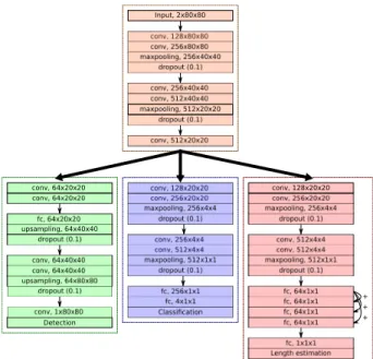
The proposed multi-task framework is based on two stages, with a first common part and then three task-oriented branches for ship detection, classification and length estimation, re-spectively (see Fig. 1). The first part is a convolutional network made of 5 layers. It is a mutual network that is used for all the 3 tasks. It is followed by the task-oriented branches. For the detection task, the output consists in a pixel-wise probability of presence of ship. It is composed of 4 convolutional layers and 1 fully connected layer. For the classification task, we consider 4 ship classes (Cargo, Tanker, Fishing and Passenger). The branch is composed of 4 convolutional layers and 2 fully connected layers. The last task is related to the length estimation. The related branch is composed of 4 convolutional layers and 5 fully connected layers.
Such settings are commonly employed in deep learning methods [11]. All the activations of the convolutional lay-ers and fully connected laylay-ers are ReLu [7]. Other activation functions are employed for the output layers: a sigmoid for the detection, a softmax activation for the classification, and a linear activation is employed for the length estimation.
conv, 64x20x20 upsampling, 64x40x40 Detection conv, 256x20x20 conv, 512x4x4 conv, 256x4x4 conv, 128x20x20 conv, 128x20x20 + + + conv, 128x80x80 maxpooling, 512x20x20 Input, 2x80x80
Fig. 1: Proposed multi-task architecture for ship detection, classification and length estimation from Sentinel-1 SAR.
2.3. Loss functions
2.3.1. Detection
The detection output is the probability of ship presence. We thus employ a binary cross-entropy loss, which is defined by:
Ldet=− 1 N N X n=1 X k∈I (yklog(p(k)) + (1−yk)log(1−p(k)), (1) whereN is the number of samples,kis a pixel of the output detection imageI,yk is the ground truth of ship presence (0
or 1), andp(k)is the predicted probability of ship presence.
2.3.2. Classification
The output for the last classification layer is the probability that the input image corresponds to one of the considered ship types. We use here the categorical cross-entropy loss, defined by: Lclass=− 1 N N X n=1 nc X c=1
(yo,clog(po,c), (2)
whereNis the number of samples,ncis the number of classes
(here,nc= 4),yo,cis a binary indicator (0 or 1) if class label
cis the correct classification for observationoandpo,cis the
predicted probability for the observationoto belong toc.
2.3.3. Length
In the length estimation network, the 4 fully-connected layers of shape (64×1×1) are connected to each other (see Fig.2). The idea is to propagate the difference between the first layer
fc, 64x1 x1 + + fc, 64x1 x1 fc, 64x1 x1 fc, 64x1 x1
Fig. 2: Difference propagation flowchart in the fully-connected layers.
and the current layer and is related to residual learning [3]. We use here the mean squared error defined as
Llength= 1 N N X n=1 (lpred−ltrue)2, (3)
where N is the number of samples, lpred is the predicted
length andltrueis the true length.
2.3.4. End-to-end training
We define the loss function of the whole network as
L=Ldet+Lclass+Llength. (4)
Our network is trained end-to-end using RMSProp optimizer [13]. The weights of the network are updated by using a learn-ing rate of 1e-4 and a learnlearn-ing rate decay over each update of 1e-6 over the 500 iterations.
3. DATA
In our experiments, we consider a dataset composed of
18,894 400×400 SAR images having a 10m resolution. Each image is accompanied with the incidence angle since it impacts the backscatter intensity of the signal. We rely on Automatic Identification System (AIS) to extract images that contain a ship in their center. Furthermore, AIS also provides us with information about the ship type and length. The dataset is very unbalanced (10,430 Tanker and only 1,071
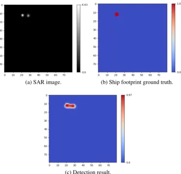
Passenger), thus requiring dedicated strategy [5]. Here we simply decided to enlarge our dataset by performing transla-tions and rotatransla-tions in order to have20,000balanced images. The images employed to train our network are80×80 im-ages containing ships (not necessarily in the center). The ship footprint ground truth is generated by thresholding the SAR image since we precisely know the location of the ship (i.e. it is the brightest pixel of the SAR image). The obtained footprint is not perfect (see Fig.3b) but is sufficient in order to train the network. Let us note that a CFAR approach could have been employed in order to extract more precisely the ship footprint [9].
4. RESULTS
We train and test our network on a PC with a single NVIDIA GTX 1080 Ti, an Intel Xeon W-2145 CPU 3.70GHz and
64GB RAM (Keras [2] implementation). For a 80× 80
image, our method can run at 55 frames per seconds. The network is trained using16,000images from the aug-mented dataset and the remaining4,000images are used for validation. Accurate evaluation of ship detection is difficult, so we conduct a visual inspection to confirm that the detec-tion is well performed by our network (see Fig.3). Let us note that the detection task has been widely addressed in the literature [10,4,6] and is not our main purpose here.
(a) SAR image. (b) Ship footprint ground truth.
(c) Detection result.
Fig. 3: SAR image (with backscatter intensity), the generated ground truth and result of detection from the network.
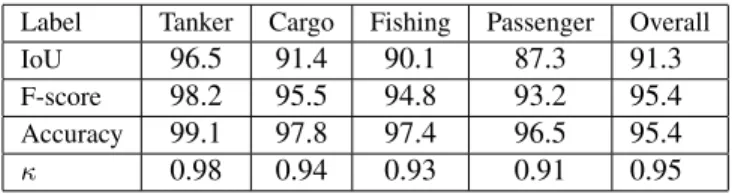
To our knowledge, the length estimation is a task that has never been investigated yet using learning-based schemes. Our framework performs well with very promising results. The length is slightly under-estimated: -2.4 m±9.5 m, which is very good regarding the spatial resolution of the Sentinel-1 SAR data. Indeed, having only the ship footprint and the spa-tial resolution of the image is not sufficient and often leads to an over-estimation of the length. The classification task is of high importance. Table1gives the confusion matrix, and several accuracy metrics are also presented in Table2. The confusion matrix shows some light confusions for passenger ships, decreasing slightly the precision for this class. Some fishing ships are classified as passenger ships impacting the recall for this class. For the tanker and cargo ships, the classi-fication is very accurate. The accuracy metrics confirm these satisfactory results with an overall accuracy and a mean F-score of 95.4%.
5. CONCLUSION
In this paper, a multi-task deep neural network approach was introduced to address joint detection, classification
Label Tanker Cargo Fishing Passenger Recall Tanker 978 7 6 9 97.8 Cargo 8 946 7 39 94.6 Fishing 1 15 934 50 93.4 Passenger 5 13 24 958 95.8 Precision 98.6 96.4 96.2 90.7
Table 1: Confusion matrix of ship classification.
Label Tanker Cargo Fishing Passenger Overall
IoU 96.5 91.4 90.1 87.3 91.3
F-score 98.2 95.5 94.8 93.2 95.4
Accuracy 99.1 97.8 97.4 96.5 95.4
κ 0.98 0.94 0.93 0.91 0.95
Table 2: Accuracy metrics of ship classification.
and length estimation for ships in Sentinel-1 SAR images. We exploit AIS-Sentinel-1 synergies to automatically build groundtruthed training and evaluation datasets. Regarding the considered architecture, a mutual convolutional branch transforms raw inputs into meaningful information. Such information is fed into specific branches for each of the three considered tasks. Ship detection cannot be totally assessed, but a visual inspection still shows our network achieved good performances. As expected, we reach state-of-the-art per-formance for the detection task but jointly deliver relevant performance for ship classification (above 90% of correct classification) and length estimation (relative bias and stan-dard deviation below 10%). We may point out that the con-sidered residual architecture for length estimation seems to be a critical feature to reach good estimation performance, but should be further investigated in order to confirm its relevance.
Further improvements will be investigated. Using false positive in the dataset would allow to evaluate the relevance of our detection network. We also consider to increase the number of classes and see if our network is robust to more complex scenarios.
REFERENCES
[1] Wentao An, Chunhua Xie, and Xinzhe Yuan. An im-proved iterative censoring scheme for cfar ship detection with sar imagery.IEEE Transactions on Geoscience and Remote Sensing, 52(8):4585–4595, 2014.
[2] Franc¸ois Chollet et al. Keras: Deep learning library for theano and tensorflow. URL: https://keras. io/k, 7(8), 2015.
[3] Kaiming He, Xiangyu Zhang, Shaoqing Ren, and Jian Sun. Deep residual learning for image recognition. In
Proceedings of the IEEE conference on computer vision and pattern recognition, pages 770–778, 2016.
[4] Miao Kang, Xiangguang Leng, Zhao Lin, and Kefeng Ji. A modified faster r-cnn based on cfar algorithm for sar ship detection. InRemote Sensing with Intelligent Pro-cessing (RSIP), 2017 International Workshop on, pages 1–4. IEEE, 2017.
[5] Benjamin Kellenberger, Diego Marcos, and Devis Tuia. Detecting mammals in uav images: Best practices to address a substantially imbalanced dataset with deep learning.Remote Sensing of Environment, 216:139–153, 2018.
[6] E Khesali, H Enayati, M Modiri, and M Mohseni Aref. Automatic ship detection in single-pol sar images using texture features in artificial neural networks. The Inter-national Archives of Photogrammetry, Remote Sensing and Spatial Information Sciences, 40(1):395, 2015. [7] G¨unter Klambauer, Thomas Unterthiner, Andreas Mayr,
and Sepp Hochreiter. Self-normalizing neural networks. InAdvances in Neural Information Processing Systems, pages 971–980, 2017.
[8] Yann LeCun, Yoshua Bengio, and Geoffrey Hinton. Deep learning. nature, 521(7553):436, 2015.
[9] Mingsheng Liao, Changcheng Wang, Yong Wang, and Liming Jiang. Using sar images to detect ships from sea clutter.IEEE Geoscience and Remote Sensing Letters, 5 (2):194–198, 2008.
[10] Yang Liu, Miao-hui Zhang, Peng Xu, and Zheng-wei Guo. Sar ship detection using sea-land segmentation-based convolutional neural network. InRemote Sensing with Intelligent Processing (RSIP), 2017 International Workshop on, pages 1–4. IEEE, 2017.
[11] Jonathan Long, Evan Shelhamer, and Trevor Darrell. Fully convolutional networks for semantic segmenta-tion. InProceedings of the IEEE conference on com-puter vision and pattern recognition, pages 3431–3440, 2015.
[12] Colin P Schwegmann, Waldo Kleynhans, Brian P Salmon, Lizwe W Mdakane, and Rory GV Meyer. Very deep learning for ship discrimination in synthetic aper-ture radar imagery. InGeoscience and Remote Sensing Symposium (IGARSS), 2016 IEEE International, pages 104–107. IEEE, 2016.
[13] Tijmen Tieleman and Geoffrey Hinton. Lecture 6.5-rmsprop: Divide the gradient by a running average of its recent magnitude.COURSERA: Neural networks for machine learning, 4(2):26–31, 2012.
[14] Liangpei Zhang, Lefei Zhang, and Bo Du. Deep learn-ing for remote senslearn-ing data: A technical tutorial on the state of the art. IEEE Geoscience and Remote Sensing Magazine, 4(2):22–40, 2016.