ISSN 1818-4952
© IDOSI Publications, 2011
Corresponding Author: Kim Nee Goh, Department of Computer and Information Sciences Universiti Teknologi PETRONAS,
Architecture of a GPS-Based Road Management System
Kim Nee Goh, Yin Ping Ng, Kamaruzaman Jusoff, Yoke Yie Chen and Yoon Yeh Tan
1 2 3 1 1
Department of Computer and Information Sciences Universiti Teknologi PETRONAS, 1
Bandar Seri Iskandar, 31750 Tronoh, Perak, Malaysia Linguamatix Sdn. Bhd, 59200, Kuala Lumpur, Malaysia 2
Faculty of Forestry, Universiti Putra Malaysia, 43400 Serdang, Selangor, Malaysia 3
Abstract: Malfunctioning traffic lights, potholes and roads in bad condition are only a few of the innumerable common thoroughfare problems that occasionally contribute to accidents. People tend to ignore reporting those issues as the channels for making a complaint is inconvenient. Accuracy of complaints is also at doubt as it tends to be general eg. Pothole at Ampang Road, in front of a police station. This paper presents the architecture of a Global Positioning System (GPS) based approach for reporting thoroughfare problems via Global System for Mobile Communications (GSM) for road maintenance management environment. To increase accuracy and efficiency, GPS can be used as it enables the tracking and tracing of the three figures of a GPS receiver’s coordinates namely longitude, latitude and altitude. Data like location, date and time will be optimized by mapping the site of where the thoroughfare problem exists in a map, with the intention that the relevant authorities could identify the spot and have the problems resolved responsively. The proposed system will serve as a handier and convenient alternative means for road users to send complaints to the relevant authorities, in addition to the existing channels, so that these issues could be addressed in a timely manner. Key words:Global Positioning System (GPS) Global System for Mobile Communications (GSM) Road
maintenance Road management Thoroughfare
INTRODUCTION and a mobile unit, like GSM in order to offer a more convenient and easy alternative means for users to make Problems with the road condition can be a nuisance complaints on road facilities and public utilities to the to drivers. In example, malfunctioning traffic lights and appropriate agencies, in addition to the existing channels potholes are common causes of traffic disarray. In such to make complaints. The combination of GSM and GPS events, lives are at risk as accidents are bound to happen. technologies can be used to deliver better road Road users could opt for various methods to lodge a maintenance management as it promises a great potential report. However, those methods may not point to the in the market for mobile telecommunication services [1]. exact location of the problem as complaints tend to be GPS devices can indeed be the most suitable channel to general. In contrast, GPS has already become a major do so, as complaints can be sent in the form of report to outdoor positioning system used for commercial, military the correct agencies, that is, when a problem is spotted and recreational purposes. Besides being used in locating virtually. This research aims to develop a prototype that points of interests and navigation, integrating road maps utilizes GPS and GSM as a method to report complaints to with positioning data obtained from GPS is the most relevant authorities, in order to better manage common application of this earth-orbiting-satellite based thoroughfare maintenance.
navigation system. Users can thus view their location on
map in real-time by plotting position data acquired from Related Works: These are the general current methods to GPS units on maps, whether they are walking, driving, lodge a report to any authorities: a) calling the authorities boating or flying. Nevertheless, current GPS technology or customer service center, b) sending an email, c). lacks the function of reporting a problem or situation. sending a Short Message Service (SMS) and d) filling up Communication can be established between a GPS device a complaint form on its website. These methods may be
inefficient, especially when one is driving or needed an artificial neural network or transferred back to the provider Internet connection. In addition, the exact location of the
problem or situation may not be exactly identified as complaints filed could be general. Some road users will choose to ignore, or it has just been long forgotten. This definitely lowers the frequency to show the gravity of a situation and inaccuracy of the problem. As GPS coordinates are used, this method of reporting allows the authorities to identify the exact location of the problem.
GPS, as the major outdoor location-based information capturing approach, has also exploited the use of wireless network to enable the transmission of position data. For instance, GPS unit is widely used in vehicle tracking systems [2-4]. Stationary servers will periodically request position data from the GPS unit placed inside a vehicle. This proposed system is indeed the reverse of this model. Instead of having servers as the requesting end (server-request application), the servers will get an entry only when there is a send command executed in the GPS-GSM unit from the user’s end. So it is deduced that such location-based tracking and tracing systems like Radio Frequency Identification (RFID) and GPS applications can indeed be put into an even greater use when they are integrated into wireless or cellular network.
RFID was used by Sriborrirux, Danklang and Indra-Payoong [5] to track bus fleet in Bangkok. Each bus is planted with an active RFID tag. A reader (based station) is installed in each telephone booth by the road side to read the location of the tag, which is when the bus passes the location. The data captured by the based station from the bus RFID tag is sent to a central server via ADSL network. This enables identification of near real-time location of the bus.
Valenteet al. [6] developed a framework to monitor in real-time dangerous goods transportation. Trucks transporting dangerous goods, in example, flammable liquids and radioactive chemicals are monitored to ensure safety to the driver and also other vehicle users. Real-time monitoring of relevant parameters inside the cargo bay (i.e. temperature, gas concentration, ionizing radiation level) uses wireless sensors in order to detect and prevent dangerous situations from happening due to the nature of the transported load. With that, GPS is used to detect the location of the vehicle at time of reading. These data are sent via General Packet Radio Services (GPRS) to a main station, where it will monitor the mechanics of the trucks. Ekpenyong,Palmer-Brown and Brimicombe [7], passively used GPS technology to collect characteristics of any ‘unknown route’ on behalf of the provider. The data collected would be processed by an on-board
to combine with data collected from other users. From the collective data, the provider would then decide whether to add that ‘unknown route’ to the road database. This technology provides the feasibility to identify roads using GPS trajectory data. Using the GPD trajectory data, snap-drift neural network (SDNN) is able to group collected points to reveal travelled road segments.
Using GIS and GPS technology, Doriwala and Shah [8] maps various facility provisions around the area of Surat City, Gujerat, India by considering different socio-economic groups. This work was done to determine facility provision in an urban area whereby households with the nearest facility is statistically identified to find the percentage allocation of each groups with identified nearest facility. It was found that higher income households tend to be concentrated near areas accessible to various facilities, as compared to the middle and lower income groups. Also, group of household has a preference to be situated near the vicinity of a healthcare center as compared to other facilities.
In Korea, highway bridges are maintained under the Special Law on Structure Safety in Korea. Inspection must be performed to ensure good structure condition. Research work by Upsani, Shrote and Wani [9] innovated a technological method for inspection, as manual judgment is subjective. Digital image processing technology and robotics was proposed to enhance inspection. However, to locate the visual image grid from and above the bridge is a very complicated procedure. Hence, Differential GPS (DGPS) was used to precisely locate the exact location of the site to be inspected.
Chen and Liu [10] combined GPS, GIS and GSM to present an intelligent vehicle monitoring system. With the integration of these three technologies, the system provides such features as signal return of real-time vehicle positioning and alarm information, sending simple control orders, displaying mobile vehicle position in both graphic and data format and alarm information returning to the control center automatically. On the other hand, Farooq
et al. [11] proposed a system combining GPS and GSM for enhancing public transportation management services in Pakistan. The system keeps track record of every bus, processes user request about a particular bus location and updates bus location at every bus stop. In both systems, GPS is used as a positioning gadget and GSM is used as a communication link between terminals. The underlying architectures of the entire vehicle tracking systems are all similar – GPS is used to capture the location of the object being tracked and GSM modem is used for mobile connections so that data can be passed.
On a different note, Habenbrock et al. [12] used GPS with GSM capabilities to monitor horses during cross-country competition or during training. Recording of critical data, in example, heart rate is useful to assess the horse condition during the exercise. A GPS system integrated with a heart rate recording system with built-in GSM for data transmission were used and tested on horses. Results from this research shows that the degree of accuracy was high and reliable. This proves that physiological data can be recorded even when remotely located, not only in animals but possible extension to patient monitoring.
MATERIAL NAD METHODS
Based on Fig. 1, after retrieving GPS signals from three satellites in the user’s vicinity, data which include three-dimensional position, velocity and time information will be calculated by the GPS unit. GPRS communication network is involved in this architecture to act as an intermediary that connects the both ends: the user and
the relevant authorities. GSM terminals are thus used at Fig. 1: Main system architecture both ends whereby the GSM terminal at sender’s side has
the duty of processing the location information acquired from the GPS unit and sending it to web server via Short Message Service (SMS); and the other GSM terminal at the authorities’ side is responsible for transferring the data to the local computer. Finally, the program embedded in the computer will integrate the position data with the maps.
The development of this system has been divided into four different modules: a) Retrieving GPS data and sending an automatically-generated message, b) Processing of GPS data by SMS server, c) Storing of GPS data into database and d) Plotting of Users’ position onto Google Maps.
Retrieving Gps Data and Sending an Automatically- Fig. 2: Python application generated Message: Nokia E71 smart phone with Symbian
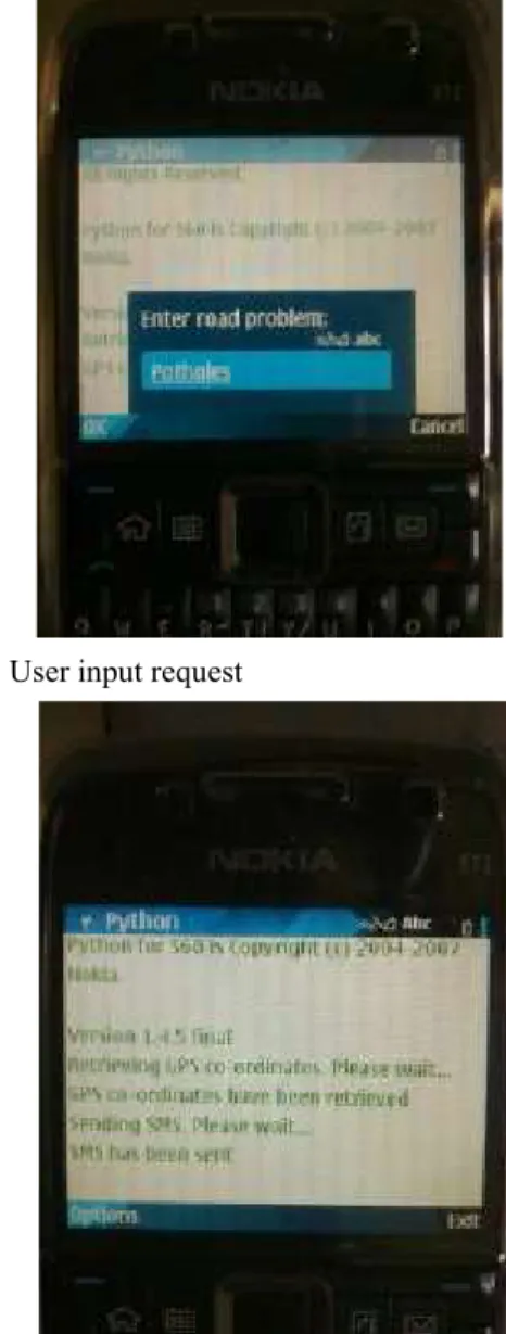
operating system was used as the sender for this system. As can be seen in Fig. 3, the user will enter any Considering the A-GPS (Assisted GPS) support and complains encountered. In this case, ‘Potholes’. In Fig. 4, featured Nokia maps embedded in this GSM phone, Nokia the Python code works by retrieving GPS co-ordinates, E71 has been chosen to do the task of retrieving GPS data which is the user’s current location. Once the co-and sending this data over the cellular network to the ordinates are retrieved, an automatically generated SMS receiving end, which is another phone that is connected is sent to the relevant authorities. In Fig. 5, the received to a computer. In this experiment, Sony Ericsson W705 SMS shows the sender’s latitude, longitude and the was used as the receiving end. A Python script has been complaint entered. The SMS text being sent will have the written to retrieve the GPS data and to generate a message following predefined format, as specified in the Python
Fig. 3: User input request Fig. 5: Receiver’s output
Fig. 4: Sender’s output and plot users’ position onto Google Maps in later phase. Latitude>[space]%latitude[space]Longitude>[space]% Plotting of Users’ Positions onto Google Maps: GMap EZ
longitude[space]%input framework is used to plot users’ positions onto Google
Processing of GPS Data by SMS Server: At the receiving sub parts: end, the GSM modem was used to connect to a local
machine. SMS server Ozeki was used to process the Retrieve Database Data and Display on Webpage: received SMS and transfer it to the computer. A PHP script has been written to build connection to the Storing of GPS Data into Database:SMS server will store stores all the incoming SMS texts from the senders. By the GPS data and related information into local database extracting the SMS text sent by the user, it is able to at authorities’ side. MySQL is used to store the messages display in a table form on the webpage. The explode
sent by the GPS-embedded smart phone. Xampp, a cross- function is used to split the message into different platform web server, is chosen as one of the main components, so that each can be assigned to the development tools not only because of its support for designated variables in the PHP script. By this the values
Fig. 6: Output at the relevant authorities’ end
creating and manipulating database in MySQL, but also of its Apache HTTP server and interpreter for PHP scripts, which will be written to display the database information
Maps. Basically this development phase consists of two
of latitude, longitude and problem of each sender can be that GPS receiver has position accuracy of 2.5m (50% out displayed in a clear and distinguishing manner as in of 17280 GPS data) and 5m (90% out of 17280 GPS data) in Fig. 6. A tracking feature is built to trace the progress of Kuala Lumpur area. This result contribute to a new the work. For instance, when the road problem a,id b, refinement in the interpretation of GPS data in the
latitude x and longitude y has been solved, the proposed GPS Reporting System: a GPS data with a
authorities can change the status of this entry by clicking latitude and longitude of 2.9211862 and 101.777972 the button “Change”. The value of this field in the possibly means that a pothole is within the range 5 meters database will be changed to “Done” after a user clicks the from the position (2.9211862, 101.777972).
button.
Display Users’ Position onto Google Maps: Google Maps alternative means for users to make complaints regarding is embedded in the PHP webpage to enable easy search thoroughfare issues to the relevant authorities. Users, and mapping for the relevant authorities. As in Fig 6, a while using a GPS navigation device on road, can send a “Go!” button is created for each entry so that different report to them upon seeing a road problem on the spot. map will be generated when different location is chosen. This increases the chances of making complaints to the The PHP script is written in such logic that the latitude party, because tendency to forget and to ignore the and longitude values will determine the output of the map, problem becomes higher as time passes. These what the end users will see. thoroughfare issues can be addressed efficiently and Benefits: This system can indeed benefit the relevant
authorities in several ways: Prioritization of Action: If a road problem is reported Road Problem Tracking: The proposed system acts as a area and the gravity of the situation. This will give an tracking system, in example, for the Department of Public indication to the relevant authorities the severity of the Works. It is an easier avenue for people to lodge problem being reported. Hence, the authorities will complaints. Authorities can keep a log of complaints and disperse resources based on problem that requires trace the work status of each task regarding road problem. immediate attention.
The status of a work can be changed and database will be
updated after a particular problem has been fixed. All CONCLUSION entries are sorted by date and time, so that old problems
are put at a higher priority. With GPS real-time tracking and tracing capabilities, Higher Accuracy: The position data will help the relevant through GSM network for identifying the sites where authorities to find the location of a particular road problem thoroughfare problems exist. This proposed system acts with a higher accuracy level. For instance, a user using as a relatively convenient channel for drivers to send SMS or Internet to file a complaint would probably input complaints with the intention that issues regarding public a street name as the location of the road problem to be infrastructure could be addressed promptly and thus fixed. First, the particular street might be a long lane, thus greater welfare will be achieved eventually. Future works making it difficult for the authorities to look for the exact suggest using a commercialized GPS device, which has location of the problem. Second, there might be two or touch screen feature, to easily make a report. With mobile more streets in the country bearing the same name. This phones, it can also image capturing capability, where proposed system eases them by providing them the exact users will be able to take a photo of the road problem and location of the problem, namely longitude and latitude. the image will be sent automatically to the receiving end. GPS Reporting System is to take GPS accuracy seriously Also, by using sensors, we can detect the road condition as the data is of high importance. Authors Mohamad, and the GPS device can automatically send the report to Mohd Alil and Ismail [13] have performed two types of the relevant authorities. Besides, the scope of the project tests to study the availability, reliability and accuracy of can also be extended to other parties such as hospitals GPS data in Malaysia. Both static positioning and mobile and police, to have wider coverage to create a civic-positioning tests have been conducted and it is proven minded community.
Higher Efficiency: This system offers a more convenient
responsively with this proposed system.
more often, collective data will show the density of an
REFERENCES 8. Doriwala, H. and N. Shah, 2010. GIS-Based 1. Shaukat, S.F., M. I. Ansari, R. Farooq, U. Ibrahim and Socio-Economic Groups in Surat City. World Appl.
M. Faisal, 2010. Mobile Phone Location Sci. J., 9(7): 740-745.
Determination in Urban and Rural Areas Using 9. Upsani, D.E., S.B. Shrote and V.P. Wani, 2010. Enhanced Observed Time Difference Technique. Development of Remote Control System for Bridge World Applied Science Journal, 6(7): 902-907. Inspection Using Robot and Digital Image 2. Lu, M., W. Chen, X. Shen, H. Lam and J. Liu, 2007. Processing Technology. International J. Computer
Positioning and Tracking Construction Vehicles in Applications, 1: 22-26.
Highly Dense Urban Areas and Building 10. Chen, P. and S. Liu, 2010. Intelligent Vehicle Construction Sites. Automation in Construction, Monitoring System Based on GPS, GSM and GIS.
16: 647-656. International Conference on Information Engineering
3. Kane, L., B. Verma and S. Jain, 2008. Vehicle Tracking (ICIE), China, 14 - 15 August 2010, pp: 38-40. in Public Transport Domain and Associated 11. Farooq, U., T. Ul Haq, M. Amar, M. Asad and Spatio-Temporal Query Processing. Computer A. Iqbal, 2010. GPS-GSM Integration for Enhancing Communications, 31: 2862-2869. Public Transportation Management Services. 2 4. Sikanen, L., A. Asikainen and M. Lehikoinen, 2005. International Conference on Computer Engineering
Transport Control of Forest Fuels by Fleet Manager, and Applications (ICCEA), Bali, Indonesia, 19-21 Mobile Terminals and GPS. Biomas and Bioenergy, March 2010, pp: 142-147.
28: 183-191. 12. Habenbrock, M., M. Due, H. Holzhausen, A. Saas,
5. Sriborrirux, W., P. Danklang and N. Indra-Payoong, P. Stadler and F. Ellendorff, 2005. A New Tool to 2008. The Design of RFID Sensor Network for Bus Monitor Training and Performance of Sport Horses Fleet Monitoring. 8th International Conference on using Gobal Positioning System (GPS) with ITS Telecommunications, Thailand, 24 October 2008, Integrated GSM Capabilities. Dtsch Tierarztl
pp: 103-107. Wochenschr, pp: 262-265.
6. Valente, F., G. Zacheo, P. Losito and P. Camarda, 13. Mohamad, I., M.M. Alil and M. Ismail, 2009. 2009.A Telecommunications Framework for Real-time Availability, Reliability and Accuracy of GPS Signal Monitoring of Dangerous Goods Transport. 9th in Bandar Baru Bangi for the Determination of Vehicle International Conference on Intelligent Transport Position and Speed. International Conference on Systems Telecommunication (ITST 2009), France, 20 Space Science and Communication, Malaysia, 26-27
-22 October 2009, pp: 13-18. October 2009, pp: 224-229.
7. Ekpenyong, F., D. Palmer-Brown and A. Brimicombe, 2009. Extracting Road Information from Recorded GPS Data using Snap-drift Neural Network. J. Neurocomputing, 73: 24-36.
Analysis of Facility Provision Accessible to Different