Volume 33
Number 466
Progress and problems in the Iowa soil
conservation districts program: A pilot study of the
Jasper soil conservation district
Article 1
April 1959
Progress and problems in the Iowa soil
conservation districts program: A pilot study of the
Jasper soil conservation district
Loyd K. Fischer
Iowa State CollegeJohn F. Timmons
Iowa State CollegeFollow this and additional works at:
http://lib.dr.iastate.edu/researchbulletin
Part of the
Agriculture Commons
,
Economics Commons
, and the
Sociology Commons
This Article is brought to you for free and open access by the Iowa Agricultural and Home Economics Experiment Station Publications at Iowa State University Digital Repository. It has been accepted for inclusion in Research Bulletin (Iowa Agriculture and Home Economics Experiment Station) by an authorized editor of Iowa State University Digital Repository. For more information, please [email protected].
Recommended Citation
Fischer, Loyd K. and Timmons, John F. (1959) "Progress and problems in the Iowa soil conservation districts program: A pilot study of the Jasper soil conservation district,"Research Bulletin (Iowa Agriculture and Home Economics Experiment Station): Vol. 33 : No. 466 , Article 1.
Progress and Problems in the Iowa
Soil (onservation Districts Program
A Pilot Study of the Jasper Soil Conservation District
by Loyd K. Fischer and John F. Timmons Department of Economics and Sociology State Soil Conservation Committee, cooperating
AGRICULTURAL AND HOME ECONOMICS EXPERIMENT STATION, IOWA STATE COLLEGE
FOREWORD
In 1939 the General Assembly ef Iewa enacted legis-latien establishing the Iowa Soil Conservation Districts Program. This program provided a means whereby farm owners and operators could organize at a ceunty level to ceoperate with federal, state and lecal agen-cies in centrelling eresion and water runoff and in im-preving the productivity of their lands. Since 1939, 100 seil conservation districts have been organized cov-ering the entire state.
During the past 20 years,. substantial pregress has been registered by the districts program in Iowa. How-ever, much werk remains to. be done in the years ahead. Approximately ene out of five farmers is ceeperating in seil conscrvatien districts. In light of the centinuing eresien and depletion ef the state's soil reseurces, the question arises "Why are n?t more farmers participat-GEORGE EASON,
Chairman
State Seil Conservatien Committee
ing in the program?" Also, of those participating in the program, "Hew well are they carrying out the recommended measures?"
To ebtain seme ef the answers to these and re-lated questions in an effert to further impro.ve the func-tioning of the Soil Censervation Districts Program, the Iewa Agricultural and Home Ecenomics Experiment Station was requested to. make a study of the program. Because ef limited reseurces, the study was limited to one district, the Jasper district.
Altheugh this study dees not previde all the an-swers to problems faced by each soil conservation dis-trict, it dees reveal important reasens why farmers do or do net cooperate in the pregram. Also, suggestiens fer obtaining more cemplete ceeperatien are offered fer censidera tien.
FLOYD ANDRE, Dean and Director Divisien ef Agriculture
CONTENTS
Summary ... 424
Introduc tion ... 425
Origin of soil conservation districts program ... 425
Iowa soil conservation districts program ... 426
Objectives of Iowa soil conservation districts program ... 426
Existing situation in achieving objectives of the program ... 427
Objectives of this study ... 427
Method of investigation and analysis ... .428
Formulation of hypotheses directing this study ... ..428
Possible explanations of district's problems ... .428
Procedures for testing hypotheses ... .428
Survey design ... 430
Selection of area ... 430
Selection of population and sample ... .431
Measurement of performance ... 432
Farm characteristics and their effect upon attainment of district objectives ... 432
Farm size in acres ... 433
Ownership-interest of farm operator ... .433
Leasing arrangements on rented farms ... 434
Potential farm productivity ... 435
Livestock program ... 436
Other factors ... 437
Reasons for complying and for not complying with specified land-use practices . .437 Field layout ... 439
Cropping sequence ... 440
Mechanical erosion-control practices ... 441
Contouring ... 441
Contour strip-cropping ... 442
Terracing ... 443
Associated land-use practices ... 443
Grassed watenvays ... 444
Commercial fertilizer ... 444
Agricultural lime ... 445
Barnyard manure ... 446
Green manure ... 446
Dynamic variables in district programs ... 446
SUMMARY
The Iowa Soil Conservation Districts Program was initiated in 1939. Since that time, about 22 percent of the farms in Iowa have plans developed with soil con-servation districts. But 78 percent of the farms have not been planned as yet, and satisfactory adoption of land-use practices has been achieved on only part of the land in the planned farms.
In this investigation various factors were identified and analyzed. in terms of their association with farmers' acceptance of district plans and application of district recommendations. The data obtained indicate that dis-trict progress was impeded significantly by (1) small size of farm, (2) tenant operatorship, (3) cash and crop-share leasing arrangements and (4) high inherent productivity of the land. Other factors tested were (1) the length of the operators' planning horizons, (2) the ages of the operators and (3) the typcS" of livestock pro-grams being pursued. However, statistical tests of signi-ficance of these latter factors were inconclusive.
The attainment of program objectives on any given soil usually requires the application of, not one, but a combination of conservation measures. The reasons why farmers apply, or fail to apply, specific land-use practices, however, are basic in determining courses of action which will best encourage compliance with district recommendations. The following are reasons, beliefs or attitudes most often expressed by farm op-erators as contributing to their failure to follow district recommendations: (1) Insufficient cooperation between landlords and tenants in arranging for adoption and maintenance of recommended practices. (2) Belief that the practices were not necessary either because they would not adequately control erosion or because ero-sion was not excessive now. (3) Insufficient knowledge of the district's program and of the practices recom-mended. (4) Belief that application of recommended
424
practices would increase capital and labor requirements without yielding commensurate additional income. (5) Farm and/or field layout would be such as to make recommended practices impractical. (6) Pressure of current financial obligations precluded the possibility of introducing practices which would increase current investment and/or reduce current income.
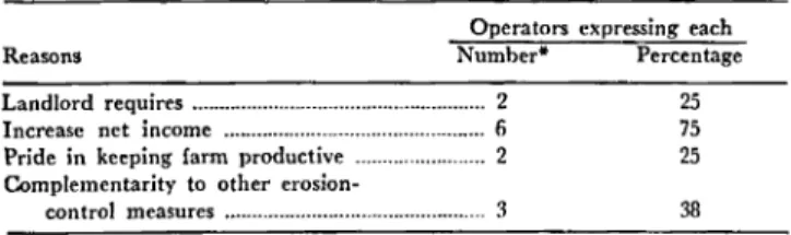
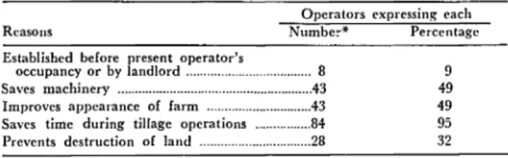
In contrast to the factors listed above which have impeded the progress of the district's program, the fol-lowing are expressed reasons, attitudes or beliefs which account for farm operators complying with district rec-ommendations: (1) Practices were established before the present operator's tenure, and established practices were maintained. (2) Landlords initiated and/or fi-nanced the application of the practices. (3) Farm and field layouts were well adapted to recommended
prac-tices. (4) Net incomes of farms were increased by appli-cation of the recommended practices. (5) Operators took pride in maintaining, or felt morally obligated to keep, soil productivity at high levels. (6) Soil conditions were such that erosion control was a minor problem. (7) A good financial position with little pressure for current income enabled opcrators to make immediate investments in land necessitated by recommended practices and wait for deferred income.
Characteristics found on farms, which have facilitated the achievement of specified district objectives, provide the foundations for further progress. Conversely, char-acteristics found on farms which have deterred the at-tainment of district goals suggest certain adjustments in the interest of furthering progress toward objectives of soil conservation. Further progress in soil conserva-tion district programs may well be founded upon the extension of the favorable characteristics and the ad-justment of unfavorable conditions in line with district objectives.
Progress and Problems
ill
the Iowa
Soil Conservation Districts
Progra~
A Pilot Study of the Jasper Soil Conservation District
1BY LOYD K. FISCHER AND JOHN F. TIMMONS2
For several decades there has been increasing public interest in the land-use practices3 applied on the agri-cultural land of Iowa and of the nation. A high rate of soil erosion on many Iowa farms has reduced, and sometimes destroyed, the productivity of the soil. Many people, both in and out of government, have expressed concern over the extent and continuing rate of soil deterioration.4 In response to this concern, pub-lic measures have been enacted and pubpub-lic agencies created for the purpose of restraining the wasteful use of soil resources."
In Iowa, one of the major approaches to providing public guidance to individual users of soil resources is the Soil Conservation Districts Program. This program represents a relatively new development in the coordi-nation and integration of the various levels of govern-ment. Through this device, federal, state and local agen-cies cooperate with farm owners and operators to main-tain and improve the present and future productivity of soil resources.
Since its inception in 1939, the Iowa Soil Conserva-tion Districts Program has made substantial progress in gaining farmer participation. However, by program standards, the rate of soil erosion loss is still excessive on much of Iowa's land. Why have not the conserva-tion objectives been more nearly achieved? More
spe-'Project 1094, Iowa Agricultural and Home Economics Experiment Station.
2Fonner research associate and professor of economics, Iowa State College, respectively. The authors are indebted to many people who helped with the study. W. Robert Park., dean of instruction, Iowa State College, helped plan the study and contributed to its progress. Members of the State Soil Conservation Committee of Iowa requested this study and
rendered invaluable assistance throughout the investigation. The contribu ..
tions of the United States Soil Conservation Service were substantial in
arranging for the soil mapping of several thousand acre. of land in the
farms of noncooperators, in devising conservation plans for the farms
of the sample noncooperators and in making adjustments in the plans of the sample noncooperators to attain a uniform le\'el of planning throughout alI sample farms. The Statistical Laboratory helped to design the sample and advised on many phase. of the study. A debt of gratitude is owed the Jasper district commissioners who advised On alI phases of the study and who were most cooperative in making district records available. Finally, special thanks are reserved for the farmerS of Jasper County who freely gave their time in providing the information upon which this study is based.
3As used in this bulletin, the term "]and~usc practices" refef5 to both
"basic" and "associated" practices. The basic land-usc practices are
crop-ping systems, contouring, contour strip-cropping and terracing for which specific recommedations are made by fields in tl'e district farm plan •.
Associated land-use practiccs arc liming, tiling, application of comlnercial
rertilizer~ spreading of barnyard manurc, plowing under a green manure,
grasscd waterways and field layout.
"As use-d in this study, soil deterioration refcrs to irreversible exploitation
of soil resu1tjng primarily from excessive rates of erosion Joss. ~lore pre-cisely, the term implies any disinvestment of soil which pcnnanently lowers
land rent, defined as net value productivity.
:JWastcfuI Use is defined as the disinvestment of soil resources without a
commensurate yield of want-satisfying goods and services over time.
cifically, why have some farmers participated and others remained outside of the program? Also, of the farmers who have initiated farm plans with the various districts, why have some carried out the district recom-mendations while others have not applied acceptable land-use practices? Why have other farmers, once in
the program, dropped out?
These are questions which gave rise to this study. Adjustments in the Soil Conservation Districts Pro-gram necessary to assure continued progress toward program objectives should be indicated by the answers to these questions. Some of these answers and their im-plications for the program have been developed in this study.
Although other studies have provided helpful infor-mation as a basis for conducting this inquiry, no pre-vious investigation has dealt specifically with the above questions. Because of the dearth of information on pos-sible answers to these questions, and because of limited funds available, this investigation has been restricted to one soil conservation district, the Jasper district in central Iowa. The information provided by this study should prove useful in furthering the districts' progress toward their objectives. Also, the procedures developed in this initial study should serve as guides for subse-quent investigations and analyses by other districts in Iowa and in other states.
ORIGIN OF SOIL CONSERVATION DISTRICTS PROGRAM
The farmer and each level of government having an interest in the productivity of the land have assumed responsibilities in soil conservation.6 Each has some-thing to offer and somesome-thing to gain. National action is deemed necessary because of several aspects of the prob-lem, as follows: (a) the importance of erosion control to future national strength and well-being; (b) the geographic character of the problems of water control, which are not limited by state boundaries; (c) the in-ability or reluctance of individual farm operators and owners and state and local units of government to as-sume full responsibility for overcoming the problem; (d) the necessity of integrating soil conservation pro-grams into other national propro-grams for agriculture
(e.g., production control, land development and pric~
"The problem of soil conservation is that of determining desirable rates
support programs); and (e) the desirability of main-taining uniformly high standards for conservation work throughout the United States.
State and local action is equally necessary because, with few exceptions, the district programs provide for neither legal coercion nor direct monetary subsidiza-tion of farm owners and operators. Therefore, the ef-fectiveness of the program is largely dependent upon the voluntary participation of agricultural land users. To gain the essential active participation of farm people, national programs must be adjusted to fit varying local conditions and the needs and wishes of individual farmers. Also, the promotion of democratic government resulting from local participation in national programs is often considered a value in itself. 7
Recognizing the desirability of federal, state and local participation in soil conservation programs, President Franklin D. Roosevelt on Feb. 26, 1937, sought the cooperation of all the states. He asked that the state legislatures pass enabling acts permitting, but not forc-ing, farm owners and operators to join together into soil conservation districts as a prerequisite for federal assistance through the Soil Conservation Service. He also submitted to the states "A Standard State Soil Conservation Districts Law." None of the states passed the standard law verbatim. Modifications were made to suit local conditions and preferences, and many of the state laws have been amended since their enactment. However, by 1945 all of the 48 states, plus Alaska, Hawaii and Puerto Rico, had passed enabling legisla-tion which the nalegisla-tional government deemed satisfactory as bases for cooperation between the United States Soil Conservation Service and the individual soil conserva-tion districts.
IOWA SOIL CONSERVATION DISTRICTS PROGRAM
In 1939 the Iowa legislature passed the law under which farmers could organize local soil conservation districts.s The first Iowa district was organized in April 1940. By February 1952, all rural areas of the state were included in soil conservation districts. Each dis-trict is organized on a county-boundary basis, except for East and West Pottawattamie districts which to-gether encompass Pottawattamie County. This makes a total of 100 soil conservation districts.
The governing body of the individual district in Iowa consists of three "commissioners" nominated by peti-tion and elected by the farm owners and operators of the district to 6-year terms of office.9 This is in line with the Iowa State Soil Conservation Districts Law which places the responsibility for the management of the soil conservation program upon local people. District commissioners, as representatives of their district, have considerable authority to achieve the prevention and control of soil erosion and the conservation of soil re-sources.
'For further development of this viewpoint see: Herman Walker, Jr. and W. Robert Parks. ~~il conservation districts: local democracy in a national frogram. Jour. Politics. 8:53849. Nov. 1946.
Iowa. Code, 1942. Sections 467A.l to 467A.12.
"As set out in the original act of 1939, only landowners were permitted to vote ip. .these elections. However, in 1953 the legislature modified the act permlttmg tenant farm operators to vote. Iowa. Code 1954. Section 467 A.5. Assistant district commissioners may be designated by the three elected commissioners as necessary to carry out the district program.
426
Among the powers of the district commIssIoners is the right to enter into "memoranda of understanding" with other governmental agencies for the promotion of soil conservation.lo Each district has in this manner entered into working agreements with the Iowa Coop-erative Extension Service, with the Iowa Agricultural and Ho.me Economics Experiment Station and with the United States Department of Agriculture and a sup-plemental memorandum with the United States Soil Conservation Service. The Secretary of the United States Department of Agriculture has designated the State Conservationist of the Soil Cons'ervation Service as his official representative relative to the districts pro-gram. Through the State Conservationist, the Soil Con-servation Service makes technicians available to assist the districts in carrying out their programs and work plans and also may provide materials, labor, equip-ment and other assistance under certain conditions specified in the memoranda of understanding.
In like manner, the soil conservation districts enter into memoranda of understanding with the Cooperative Extension Service. The Extension Service cooperates with the district commissioners by supplying informa-tion and providing personnel needed in the develop-ment of the educational aspects of the district programs and work plans, in suggesting plans and methodS' for developing effective educational programs, in furnish-ing personnel for carryfurnish-ing out these programs, in train-ing local leaders and in conducttrain-ing soil conservation demonstrations. County extension directors, as the local representatives of the Extension Service, cooperate with the districts in correlating the soil conservation educa-tional efforts of all agencies within each district.
In accordance with the districts law, the Agricultural and Home Economics Experiment Station of Iowa State College cooperates with the districts in the con-duct of research relative to problems confronting the districts. .
The districts law provides for a State Soil Con-servation Committee to serve as the administrative body at the state level and sets forth the composition, powers and duties of this committee.l1 In general,
after a soil conservation district has been organized, the duties of the state committee are to offer stich as-sistance as may be appropriate to the commissioners of the districts in the carrying out of any of their powers and programs. Such assistance includes coo.rdination of the program of all of the districts in Iowa so far as this may be done by advice and consultation. The state committee also acts as the intermediary through which the individual districts obtain the cooperation and assistance of the agencies of the United States government and the agencies of the State of Iowa. The state committee is responsible for the allocation, to the various districts, of funds appropriated for the program by the General Assembly.
OBJECTIVES OF IOWA SOIL CONSERVATION
DISTRICTS PROGRAM
In the Soil Conservation Districts Law of Iowa it is
. .. declared to be the policy of the legislature to provide '.Ibid., Section 467 A. 7.
for the restoration and conservation of the soil resources of this state, and for the control and prevention of soil erosion and thereby to preserve natural resources, control floods, prevent impairment of dams and reservoirs, assist and maintain the navigability of rivers and harbors, pre-serve wildlife, protect the tax base, protect public lands, and promote the health, safety and public welfare of the people of this state."
The Soil Conservation Districts Program is conceived by the legislature to be one of the means by which these goals may be achieved. It should be pointed out, however, that these broad ends are subject to continuous modification as the definitions of various terms (e.g., public welfare) change. Furthermore, this passage states the objectives only in relative terms (i.e., restore, con-serve, control, prevent, maintain, precon-serve, protect and promote) and does not specify to what extent or to what level the given ends shall be achieved.
The law further specifies that districts are empowered "To develop comprehensive plans for the conservation of soil resources and for the control and prevention of soil erosion within. the district . . . ."13 From the law and from discussions with administrators of the pro-gram, this study has determined that the primary goal of the districts program is the attainment of what has been termed a "safe level of erosion loss" on all agricul-tural land.14 This end is thought to be consistent with, and a means of approaching, the general objectives pre-sented in the districts law.
However, maximum permissible rates of soil loss vary between soil types; estimates for the various soils in Iowa usually range from 2 to 8 tons of soil loss per acre per year. No attempt has been made in this study to establish the maximum permissible rate of soil loss for each field or the current average rate of soil losses. Instead, the basic land-use practices recorded in the farm plans, as revised for this study, serve as the ob-jectives of the program.15 This goal recognizes the fact that a district's objectives as applied to each farm are pointed out to the farm operator and owner by the district farm planner as farm plans are developed. Fur-thermore, the district governing body approves these practices as necessary means to accomplish district goals. Explicit in this study is the assumption that the average rates of soil loss will not exceed the district's goal on planned farms if the recommended land-use practices are applied. Consequently, the emphasis of this study is on discovering and analyzing factors which impede and those which encourage the application of land-use practices recommended by the district.
The "norm to be achieved" for this study for each field is, then, the application of the combination of the basic land-use practices recommended for that particular field. However, the application of an alternative com-bination of practices on a given field will not be con-strued as a departure from the district norm unless the substituted combination of practices results in an aver-age soil loss considered by the district to be in excess of the maximum permissible.
"Iowa. Code, 1954., Section 467A.1. l3Ibid., Section 467 A. 7.
uThis cnd·in-view was given by Jasper district commissioner'S as the most important and most urgent objective of their district's program. liAs explained ill the next section, the land-use plans of all the sample farms were adjusted by the district farm planner so that the applicatIOn of the practices recommended for each farm would, presumably, just
at-tain the erosion·control norm of the district.
An operational objective, or end-in-view, of the dis-tricts program is the desire that all agricultural land and land users be brought into the program. This end is viewed by the district governing body as a means of approaching the ultimate goal of gaining accept-ance of the land-use practices which will adequately control erosion. Land-use practices, other than those recorded in the farm plans, being applied on soils of a given land capability class were compared with the al-ternative land-use practices set out in the Technical Guide of the Soil Conservation Service.1G The
combi-nation of land-use practices being applied on any field was considered acceptable if the resultant soil loss would not exceed the rate associated with practices recom-mended in the "Guide" for soil of· the same capability.
EXISTING SITUATION IN ACHIEVING OBJECTIVES OF THE PROGRAM
As of Jan. 1, 1958, Iowa soil conservation districts had developed basic conservation pIims for 42,200 farms which represent 21.8 percent of all Iowa's farms. These farms encompass 7,594,697 acres representing 22.3 per-cent of Iowa's farmlandY Furthermore, nearly all farmers, whether or not they are participating in the districts program, have applied some acceptable land-use practices (e.g., permanent meadow) on at least part of their land. Some operators adequately control erosion on all of their land. In other words, the situation rela-tive to achieving district objecrela-tives reflects considerable accomplishment. An explanation of how and why this level of success has been achieved should provide bases for devising means of promoting further progress.
Despite these elements of Sllccess, the ultimate ob-jectives of the program have not ~een fully achieved. As of Dec. 31, 1957, 150,733 (78.2 percent) of Iowa's farm operators were not participating in the program with basic conservation plans. Included in these farms are 26,449,836 acres (77.7 percent) of Iowa's farmland. Furthermore, departures from district objectives are found, not only on the farms of noncooperators, but also on the farms of cooperators. In this study, the prob-lem has been defined, identified and presented in terms of (a) farms on which plans have not been initiated and (b) nonapplication of land-use practices planned for cooperators' farms. These are interpreted as the failure elements in the situation. They constitute the existing problem.
On J ECTIVES OF THIS STUDY
This study attempts to (1) discover why some farm-ers participate in the program while othfarm-ers do not and, of those farmers who participate to the extent of initiat-ing farm plans, why some of them achieve the objectives of erosion control while others do not, (2) to ascertain and analyze the principal obstacles and resistances which have impeded the work of the soil conservation districts program and (3) to discover and develop means for the removal or mitigation of these obstacles and resistances.
"Technical Guide. SCS, USDA.
"Percentages are based on 192,933 farms and 34,1H4,533 acres reported in the 1954 U.S. Census of Agriculture. Iowa. In addition, 19,573 fanners, controlling 3,605,510 acres, have entered into initial plans and arc in the process of developing basic conservation plans.
Thus, the study is intended to provide helpful ideas arid information (1) for further research into soil con-servation district programs and (2) to assist technicians and administrators of soil conservation districts in their efforts to improve their programs.
METHOD OF INVESTIGATION AND ANALYSIS The soil conservation districts of Iowa possess neither power to force nor funds to subsidize compliance with district objectives. Consequently, their problem is one of gaining (a) voluntary participation in the program by farm owners and operators and (b) application by farm operators of the land-use practices recorded in the farm plans.
These two aspects of the program possess a "means-ends" interrelationship. That is, inducing farmers to participate in the program is viewed by district admin-istrators as a means of gaining acceptance of recom-mended land-use practices, which, in turn, are means of attaining a desirable level of erosion control. In like manner, the control of soil erosion is not only an end-in-view, but also a means of attaining the more ultimate end of maximizing net value, over time, of the goods and services produced from agricultural resources.
Cooperation in the district program and compliance with district recommendations are obviously not com-pletely interdependent. Therefore, these two objectives must be treated separately, at least to some extent. Con-sequently, this analysis has been divided into two seg-ments. Samples were drawn from cooperating farms
(i.e., those having basic farm plans) and from noncoop-crating farms (i.e., those farms which had not previously been planned). These sample farms have been carefully investigated to determine if special differentiating char-acteristics exist (a) between noncooperating and coop-erating farms and (b) between coopcoop-erating farms from three different levels of compliance with district recom-mendations. Also, the operators of all of the sample farms were asked to give the reasons why they had or had not carried out district recommendations.
FORMULATION· OF HYPOTHESES DIRECTING THIS STUDY
The Jasper Soil Conservation District has two objec-tives considered in this study. The Jasper district gov-erning body desires that, eventually, (1) all Jasper agri-cultural land users cooperate in the district program and (2) all agricultural land be farmed under com-binations of land-use practices which achieve district conservation objectives. The achievement of either ob-jective does not ensure the attainment of the other, nor does the failure to attain one preclude the achievement of the other.
As a result of the dual objective of the Jasper district program, there arise two problems which may be de-limited by the following hypotheses:
1. The ultimate objective of the Jasper district that all its farmers enter into working agreements (i.e., basic farm plans) with the soil conservation district, is far from being achieved.
2. On the farms in Jasper district, both of noncoop-428
erators and of cooperators, there are many fields on which the land-use practices being applied are not ad-equate according to the standards of the district.
The first of these two hypotheses has been tested by determining the cumulative number of basic farm plans signed by Jasper district farm owners and operators as compared with the total number of farms in Jasper County. The second of these two hypotheses has been tested by comparing the land-use practices being applied on the fields of a sample of farms with the practices recommended by the Jasper Soil Conservation District. In these ways, the extent of achievement of district ob-jectives was determined.
POSSIBLE EXPLANATIONS OF DISTRICT's PROBLEMS
In attempting to explain or diagnose these problems, a secondary set of hypotheses proposes that:
1. Certain characteristics of farms tend to impede the acceptance of farm plans and compliance with district land-use recommendations.
2. Certain beliefs, customs and habits of farm op-erators tend to make farmers resist complying with dis-trict objectives.
Characteristics of the sample farms were analyzed to determine their association with the attainment of dis-trict objectives. Relationships between (a) the extent of achievement and (b) the following farm character-istics, were tested: ( 1) farm size in acres; (2) owner-ship-interest of the farm operators; (3) leasing arrange-ments on rented farms; (4) potential crop productivity of the farms; and (5) livestock programs.
In addition to the analysis mentioned earlier, another approach to explaining the existence and extent of the problems confronting the district was the questioning of the operators of the sample farms as to their reasons for complying or for not complying with district objec-tives.18 From their stated reasons, an indication was obtained of the relative importance of various factors which might promote or impede district progress.
Strong features of the district's program and charac-teristics common to those farms which have attained specified district objectives suggest the foundations for further progress. Conversely, weak features of the dis-trict's program and characteristics common to farms which have failed to attain specified district objectives, suggest program adjustments and the need for a better understanding of soil conservation in the interest of furthering progress toward objectives of the district.
PROCEDURES FOR TESTING HYPOTHESES
The delimiting hypothesis relative to the failure of farmers to accept basic farm plans is readily tested. Table 1 gives the cumulative numbers and percentages of Jasper farms which have been planned for each year since the inception of the program. The table also gives the numbers and percentages of acres encompassed. Although these data appear accurate and precise, their significance is indeterminate because (a) planned farms represent all degrees of seriousness of erosion problems, (b) the level of planning developed with cooperators is
18These interviews were restricted to fann operators; therefore, the views of landlords are not represented.
TABLE 1. CUMULATIVE NUMBERS AND PERCENTAGES OF JAS-PER COUNTY FARMS PLANNED BY THE SCD, AND NUMBERS AND PERCENTAGES OF ACRES ENCOMPASSED BY PLANS AT THE
END OF EACH FISCAL YEAR, 1942-1957, INCLUSIVE. .
No. of Porcenl No. of Percent of
farms of all acrE'S en- all agricul ...
Year planned* farmst compassed: tural land§
1942 ... 9 0.3 3,567 0.8 1943 ... 34 1.3 8,240 1.8 1944 ... 93 3.4 9,677 2.2 1945 ... .163 6.0 27,592 6.2 1946 ... 214 7.9 36,060 8.1 1947 ... 277 10.3 %,724 10.5 1948 ... 332 12.3 58,792 13.2 1949 ... .378 14.0 65,880 14.8 1950 ... 447 16.6 77,077 17.3 1951 ... 481 17.8 82,048 18.4 1952 ... 529 19.6 89,725 20.1 1953 ... 508·* 18.8 79,087 17.7 1954 ... 580 21.5 90,871 20.4 1955 ... 616 22.8 97,079 21.8 1956 ... _.636 23.4 100,220 22.5 1957 .. _ ... _ .. _ ... _ ... 689 ~5.4 110,785 24.8 "Excluding plans cancelled for any reason.
tn.sed on U.S. Census of Agdculture. Preliminary report. Jasper County. 1954. Land in farms, 445,689 acres.
tAdditional acres have been incorporated into the plan nod farms, by rental
Or purchase, of which the district has no record.
§Based on U.S. Census of Agriculture. 01'. cit. Land in farms, 445,689
aCres.
**In 1953 farm plans were categorized as initial, advanced and basic. The adoption of this system involved changes in figures which accou~ts for the discontinuity. Since that time the system has changed agam, and only district cooporators with basic plans are reported.
not uniform among farms and (C) the extent to which recommended practices were applied varies from none to all on the planned farms.
The general procedure for testing the delimiting and diagnostic hypotheses involved selecting a stratified ran-dom sample of farms from one soil conservation district. Information regarding the problematic situation on the sample farms has been assem~led and analyz~d for the purpose of testing factors whIch .a~e hypo~heslzed . to ~e
(a) important deterrents to partICIpatIOn m the dlst;lct program and/or to the acceptance of land-use practIces which are compatible with district goals or (b) reasons for the continuance of land-use practices which are in-compatible with district goals.
The testing of these hypotheses has been performed in two ways: (1) procurement and analysis of data rela-tive to specified farm characteristics for the purpose of investigating the possibility of correlation between such characteristics and the extent of compliance with dis-trict objectives within such farms and (2) an inquiry into the stated reasons of farm operators for complying or failing to comply with district recommendations.
In proceeding with this investigation, it was necessary to devise a means for delineating the specific problems, relative to the objectives of the district program, exist-ing on individual farms. Since the objectives' of the program for any farm have been presented in terms of recommended land-use practices, departures from this norm in terms of the application of land-use practices which will not achieve district conservation objectives, serve to delimit the problematic situation on each farm. As a practical operational matter, districts often enter into initial working agreements (with farm owners and operators) which do not spe~ify all of t?e l.and-u~e p.rac-tices necessary to fully achieve the dlstnct obJectIVes. Such plans are viewed by the district as "opening wedges" through which adequate conservation plans may eventually be worked out. To provide a uniform
and meaningful norm, the plans for all the sample farms of cooperators were reviewed by the district farm planner. He made adjustments in the recommended land-use practices necessary to attain (a) uniformity in plans among farms and (b) compatibility of the plans with ultimate district objectives. In addition, from soil maps provided by the SCS, the farm planner devised comparable plans for a sample of farms drawn at ran-dom from the noncooperating farms of the district.
In this investigation, the land-use practices- applied by the farmers on each field of tillable land were com-pared with practices recorded in the farm plans. IS The application on a given field of the specified practices was considered to be the attainment of the "norm" of the district relative to achieving a "safe level of erosion loss" for that field. Conversdy the application of com-binations of land-use practices, not as effective in ero-sion-control as the recommended practices, was con-sidered as below the district norm. No particular merit or significance was attached to restricting rates of soil loss to levels below permissible maximums because the value to society of such action is indeterminate and may be negative and because such action on some land would not compensate for the use of practices which would result in excessive erosion on other land.20
Land which was not tillable, as defined above, was excluded from this measurement because the mainte-nance of permanent vegetation on a tract was of itself considered an acceptable use of land. Consequently, a farm having large acreages of land incapable of being tilled under prevailing cultural practices would tend to rate high in compliance with the district norms regard-less of the extent to which the farm's tillable land was abused.
The characteristics of farms relative to certain factors were hypothesized to have an effect on the attainment of district objectives. Direct correlations between spe-cified firm characteristics and the extent of the opera-tors' compliance with district recommendations is con-sidered to be evidence substantiating the hypotheses. Inverse correlations are contradictory evidence ..
Reliability of estimates from the sample of farms was calculated and is presented in terms of chi square tests of interdependence throughout this report. Assum-ing randomness of sample and disregardAssum-ing errors of measurement, an estimate was obtained whereby the degree of confidence might be placed in the results of the study.
The number of times a sample may be subdivided and still yield statistically significant answers is- very def-initely limited by the size of the sample. Be~ause of limitations on the size of the sample, confoundmg fac-tors were a difficult problem. Where statistically sig-nificant results supporting the hypotheses were obtained, despite the tendency of coexistence of factors hypothe-sized to be competitive in their effect, such results would
'OA field i. defined as a contiguous tract which is homogeneo"s as to district recommendations and as to land-use practices being applied. Practices recommended and practices applied mayor may not be the same. Land i. considered to be tillable if it has been in rOW crops or if row crops
have been recommended for it. •
20The failure of fann operator to USc his land to the extent of its capab,l-ities: commensurate with maximum productivity over time, would reduce the' net value of product over time. If, for two fields, the maximum permissible annual rate of soil loss.is 5 tons per acre, a loss rat!': for example, of 2 tons on One field WIll not compensate for the raplll de-terioration of the second field undergoing a loss rate of, say, 30 tons per acre.
seem to provide additional verification.21 Where test r~sults failed to support the hypothesis when competi-tIve factors were confounded, an acceptable test has not been made since the effects of competing factors would tend to cancel out. The limited size of the sam-ple did not permit further subdivisions which would allow separate testing of the factors in question.22 Where complementary factors tend to coexist, significant re-sults give little indication of the relative effects of each factor but do indicate that one or more of the factors b~ing considered is important.23 Analysis of the reasons
gIVen by farm operators for their decisions relative to
t~e
practices recorded in the plans for their' farms, con-stItuted the best method available for discovering the factors which motivated their actions.The second aspect of this investigation concerns the stated reasons of farm operators for accepting or reject-ing district recommendations.
21e .g ., owner·operated farms tended to be small in size.
~~e.g., owner-operated f!1rms according to size of farm. e.g., owner-operatorshlp and long planning horizon.
SURVEY DESIGN
SELECTION OF AREA
!he area sel~cted ~or .this investigation was the Jasper SOlI ConservatIOn Dlstnct. The study was restricted to one district because of the limited resources available and because of the large amount of cooperation and assistance required from the district administrative and technical staffs. Furthermore, it was considered essential that the level of farm planning be consistent throughout the sample.24 Such consistency could best be attained by ~aving the farm plans be, to as large an extent as pos-SIble, the product of one technician.
Jasper district was chosen for the following reasons: .(a) Only. farms planned prior to June 30, 1950, were mc!uded III the sample to allow the operators time to apply recommended practices. Jasper district was estab-lished in April 1942 and thus had a relatively large number of farms planned prior to 1950. (b) The
dis-"The applicatio!, of th.e practice~ recorded in. e,,;ch sample farm plan would, ldeaIIy, Just attam the eroslOn'control obJectlves of the district.
__ _ Tentative Bou.ndary
111111 Gradational Boundary
Figure 1. Jasper district and its geographical relationship to the principal soil association area oi Iowa.
430
Principal Soil Associations·
B: Soils 01 bottomland, CC: Carrington and Clyde
CpC: Carrington, plastic till phase, and Clyde CL: Clinton and Lindley
CWo Clarion and Web,ter F: Fayette
FDS: Fayette, Dubuque, and Stony Land GH: Grundy and Haigb
GPS: Galvab , Primghar&, and Sacb
M: Mar.hall
MIH: Mononab, Ida&, and Hamburgb
Mo: Moodyb
MPS: Marcus, Primgharb , and Sacb
MT: Mahaskab and Taintorb SCW: Stordenb , Clarion, and Webster SGH: Shelby, Grundy, and Haigb SSE: Shelby, Seymourb , and Edina SSW: Shelby, Sharpsburgb , and Wintersetb
TD: Tama and Downsb TM: Tama and Muscatine WL: Weller and Lindley >Iowa Agr. Exp. St •• in cooperation with Div. of Soil Survey, U.S. Dept. of Agr. 1948. bNew names not on county soil maps.
trict is centrally located and consequently was readily accessible for study and also has climatic conditions tending to be average for the state. (c) The physical conditions are diverse, representing four of the major soil association areas in the state (see fig. 1). As a con-sequence, problems of a physical nature encountered on the sample farms have implications over much of the state. (d) The Jasper district commissioners and farm planners were willing to cooperate in the plan-ning and conduct of the study.
Conclusions reached from information obtained in one district can be generalized to other districts only within limits and with considerable caution. But, in view of the considerations mentioned, this initial study was restricted to one district with the hope of devising means by which other researchers and district administrative and technical staffs might conduct similar studies. In this way the specific problems confronting each district can be recognized, and action can be taken to overcome the obstacles discovered.
SELECTION OF POPULATION AND SAMPLE
Among the objectives of this study is the analysis of the strong and weak features (success and failure ele-ments) of the district's program in relation to farmers who are participating and also those who are not.25
As a consequence, the scope of the study encompasses both cooperating and noncooperating farms.
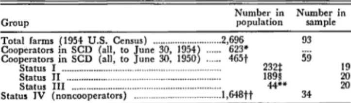
Cooperators. The population of cooperators is a total
of 465 farms having basic farm plans initiated prior to July 1, 1950.26 This number excludes 52 farms on which the plan was cancelled because of change in ownership. These 52 farms were not included because the present owners were not principals in the agreements signed with the district. If any of the 52 farms have been re-planned, the new plans, if initiated prior to July 1, 1950, had an equal opportunity of falling into the sample. If a new plan was initiated after June 30, 1950, the farm would not be in the population as defined. These 52 farms are, however, indicative of the dynamic setting in which the program operates.
From the population of 465 cooperators, a stratified random sample of 60 was drawn (table 2). The stratifi-cation was accomplished by having the district farm planner, who has held that position since the organiza-tion of the district in 1942, separate the farms into three categories according to their relative progress toward the district objective of erosion control. A sample of 20 farms was drawn at random from each of the three strata.
Planned farms on which the district norm relative to erosion control had, in the judgment of the farm planner, been achieved, or toward which satisfactory progress was being made, were designated Status 1. Of the 465 farms, 232 were placed in this category. Of the 20 farms selected from this stratum, 2 farms com-bined during the process of analysis into 1 unit (firm) leaving a total of 19 cases in this segment of the sample.
"Farm operators whose farms have been planned by the distdct will, hereafter, be referred to as "cooperators" and all others referred to as
ctnoncooperators." ,
"Operators whose farms were planned after 1950 may not, in many in. stances, . have had time to establish all land·use practices recommended despite their full intentions to do so.
TABLE 2. POPULATIONS AND SAMPLES FROM JASPER SOIL CONSERVATION DISTRICT.
Number in
Group population
Total farms (1954 U.S. Census) ... 2,696
Cooperators in SCD (all, to June 30, 1954) ... 623*
Cooperators in SCD (all, to June 30, 1950) ... 465t Status I ... ... 232t Status II ... 189§ Status III ... 44** Status IV (noncooperator.) ... .1,648tt Number in sample 93 59 34 19 20 20
*Number of agreements signed prior to July I, 1954, a rew 01 which were the second agreement for a given farm.
tFarms (50 aCres or larger) planned by the district pdor to July I, 1950. tPlanned farms on which conservation practice. have been established or on which satisfactory progress toward these objectives is being made, as judged by the district farm planner.
§Planned farms On which the district objective. have not been attained and on which progress is being made toward the norm at less than a satisfactory rate.
"Planned farms which are below the norm and On which no progress i. being made toward the district objectives or on which the plan has heen cancelled.
tt Farms (over 50 acres in .ize) which had not been planned by the district prior to July I, 1954. Number derived from U.S. Census of Agdculture. Iowa. Jasper County. 1954.
Among the 465 cooperators in the population, 189 were, as evaluated by the district farm planner, making progress which was less than satisfactory toward the dis-trict norm. These farms were designated as Status II.
The third category, comprising 44 farms, was below the norm of the district and had plans on which no prog-ress was being made or plans which were cancelled for reasons other than change of ownership. These were termed Status III farms. It should be pointed out that the operators of Status III farms are cooperators only in the sense that their farms had received aid from the district in developing plans for their farms. They were not making use of the farm plans nor were they utiliz-ing district facilities or personnel. In several instances, the farms had been planned before the tenure of the present operator, and in some cases, the present operator was not even aware of the plan. This group constitutes a failure element in that the recommended practices deemed necessary by the district to adequately control soil loss have not been applied despite the district re-sources expended on the farms.
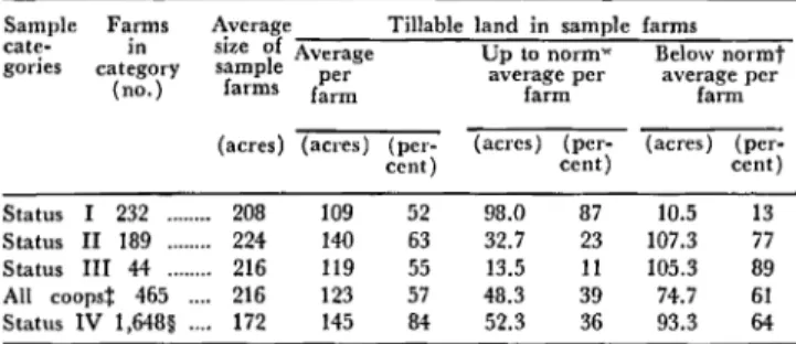
As stated previously, the categorization of the coop-erating farm firms was performed by the district farm planner. These classes were established by him on the basis of his inspection, records, knowledge and judg-ment as to their relative progress toward district ob-jectives. Empirical analysis of the farms selected from the three categories strongly support the stratification as established. The data in table 3 indicate that on Status I farms, district objectives have been substantially achieved. The operators of Status II farms have been much less successful. They have achieved district ob-jectives of erosion control on 23 percent of their tillable acres. Status III farmers, having attained the erosion control norm on only 11 percent of their tillable acres, have made even less progress.
The stratification of the population of cooperators is further verified by the data in tables 11 and 14. These data compare the practices applied with practices rec-ommended. As would be expected, meadow crops and mechanical erosion-control practices are being applied freely on Status I farms, less freely on farms of Status II and Status III.
TABLE 3. STATUS OF SAMPLE FARMS AS RELATED TO THE ATTAINMENT OF THE DISTRICT OBJECTIVE OF
EROSION-CONTROL ON TILLABLE LAND. Sample cate-gories Statu. I Farms in category (no.) 232 Status II 189 Status III 44 All coopst 465 .... Status IV 1,648§ ....
Average Tillable land in sample farms
size of A U
sample verage p to normw Below normt
farm! per average per average per
farm farm farm
(acres) (acl'es) (per- (acres) (per- (acre.)
(per-cent) cent) cent)
208 109 52 98.0 87 10.5 13
224 140 63 32.7 23 107.3 77
216 119 55 13.5 11 105.3 89
216 123 57 48.3 39 74.7 61
172 145 84 52.3 36 93.3 64
* Acceptable land-use practices being applied. tUnacceptable land-use practice. being applied.
;The tc~m. "coops" in this and in succeeding tables refers to cooperators In the dlStrtct program.
§Estimated.
Noncooperators. For noncooperators, who have been
designated Status IV, the population includes 1,648 farms in Jasper district, 50 acres or larger in size, whose owners have not entered into an agreement with the soil conservation district. The sample of noncooperators was obtained from 60 quarter-sections selected, three at random from each of the 20 survey townships in ~asper district. All farms from the population, as de-fmed above, whose farmsteads lay in the 60 quarter-sections comprised the sample of 34 farms.
Farms smaller than 50 acres in size were excluded from the sample of noncooperators because (a) many of these small places are not farms but are rural resi-dences, and (b) the small size of the farm in these cases is likely to be such an overriding consideration that the effect of oth.er. cha.racteristics would be seriously con-founded. ThiS IS eVidenced by the fact that none of the farms in the "cooperator" population were smaller than 50 acres.
MEASUREMENT OF PERFORMANCE
Table 3 presents a measurement of the average prob-lematic gap on the farms in each of the categories.27 The measurement is ordinal in the sense that the amount by whi~h the average rate of soil loss per acre on any gIven field exceeds the maximum permissible is not
cal-culated. This lack of a quantitative measurement would not bias the. results from this study if the loss to society from the faIlure of farm operators to attain the district norm (i.e., on fields designated "below" norm) averages the same per acre throughout all sample categories. Al-though such does not appear to be the case, further consideration indicates that this difference does not in-validate but, rather, reinforces the evidence obtained. Analysis of the data indicates that the fields on fanns in category I which have been designated "below norm" are on the average substantially nearer the norm than are similarly designated fields in category III. Conse-quently, the rate of soil deterioration would probably average much higher on "below norm" acres of the latter category of farms. In making comparisons be-~ween the .average per~ormances of the farm operators m the val'lous categol'les of cooperators, the tendency
2TTh~ measurement of the "problem" on each farm is in terms of acreS
of tillable land on which the land-use practices being applied permit a
r!\!~ !,'If ~rosion loss in excess of tbe maximum permissible.
of Status I farms to be nearer the district objectives than Status III farms, both in terms of proportion of acres up to the norm and also as to proximity to the goal on "below norm" acres, makes more distinct the differences between these categories. Therefore, comparisons of the data in table 3 relative to the various categories of co-operators are more meaningful than would otherwise be true.
On the other hand, the data for Status IV (i.e., non-cooperating) farms are not strictly comparable to the information for farms in categories I, II and III (i.e., district cooperators). This is true because the farm plans for Status IV farms were devised from the land-capabili-ty maps of the respective farms without consultation with the farm operator. Furthermore, the farms were planned on a very intensive basis, and as a consequence, large acreages of land planned for crop rotations are presently in permanent vegetation and are thus auto-matically up to the district norm.28 A further weakness of the cumulative data for Status IV farms is that there is no homogeneity among the farms within this cate-gory as to progress toward or attainment of the district norm of a "safe level of erosion control." Variations be-tween farms within this stratum are as great as the vari-ations between farms of this and other strata. In other words, some of the operators of the· noncooperating farms have reached the district norm on their entire farm; others are far below the norm on most of their tilled land.
Since the data in table 3 for Status IV farms is sub-ject to the limitations above, no attempt will be made in this study to classify these farms, as a group, relative to t~eir attainment of the district objectives. Noncoop-eratmg farms are treated as homogeneous only in the ~e?~e that on none of them has a district farm plan been ImtIated. Consequently, characteristics hypothesized to be favorable to plan initiation would be expected to occur more frequently on cooperating farms.
F ARM CHARACTERISTICS AND THEIR EFFECT UPON ATTAINMENT OF DISTRICT
OBJECTIVES
. This investigation has been conducted along three hne~ of approach. The first approach, discussed in this sectlOn, IS the assembly and analysis of information relative to specified. farm charac~er!stics. This analysis attempts to determme the aSSOCIatIOn of certain char-~cteristi~s ~f farms with their «;,perators' participation m the dIstrIct program and their compliance with dis-trict recommendations. It has been hypothesized that some characteristics of farms tend to inhibit and others to facilitate the progress of the districts program in terms of both the number of farms planned and the extent of application of planned practices on the farms of cooperators.
The f.ac~ors tested are: (a) farm size in acres, (b) ownership mterest of operator, (c) leasing arrangement on rented farms, (d) potential farm productivity (e)
live~tock
program, (f) age ofo~erator
and (g)pla~ning
honzon of operator. InformatIOn relative to these fac-2SPe,rrpanent vejretation is~ of itself, . considered to be, in most cases ators has been obtained from the farm operators through personal interviews. The data from these schedules have bee~ ~nalyzed and reveal special differentiating charactenstlcs between those farms on which district objectives have been achieved when compared with other farms in the district.
The characteristics tested were selected on the basis of previous knowledge and preliminary investigation because they were deemed to be relevant and capable of being tested with considerable precision with the sample selected. These characteristics are not however
con~i~ered
to be the only factors influencingfarmers~
declSlons. Others may be of equal or greater import-ance. Furthern:ore, a farmer's determination to carry ou.t a conserv~tlOn program may succeed despite the eXlstence on hIS farm of any or all of the hypothetical obstacles test~d. . Conv~rsely, the absence of any or all of the tentative ImpedIments does not ensure compli-ance with district recommendations.FARM SIZE IN ACRES
. Among the characteristics of farms which apparently mfluence the owners' and operators' decisions relative to compliance with district objectives is the factor of "size of farm in acres." It was hypothesized that farms relatively large in acres would lend themselves to a soil conservation program more readily than would smaller farms.
There are a number of possible reasons why owners and operators of large farms might more readily accept and carry out a district farm plan. In the first place, larger farms tend to have larger fields which are more readily adaptable to mechanical conservation practices (e.g., contour and strip-crop farming). Furthermore, owners and operators of large farms may be in a stronger financial position and thus be better able to sacrifice some current income and/or finance invest-ments in land.29 Also, large farms are apt to have
rou!?hage-cons~ming livestock, machinery, buildings and eqUipment whIch are more adequate and better adapted to c0!1servation .farming. Finally, large acreages may permIt the attamment of adequate erosion control !argely by a mor~ extensive use of land (e.g., by reduc-mg the proportlOn of row-crops in the cropping se-quence) .30 Thu.s the use of mechanical practices, such as terraces, which seem to encounter more resistance from farm operators is minimized. On the other hand small farms may tend to be more severely depleted and eroded from previous exploitation and, as a conse-quence, require more extensive and effective erosion-control measures.
EFFECT OF FARM SIZE ON PLAN INITIATION
The data in table 4 concerning status of farms as related to farm size indicate that size of farms in acres has a pronounced effect on the initiation of farm plans.
'~l1le i!,itiation of any change in farm~ng oper';'tion. which require. addi. tional ,,!vestlI!ent or . reduced current mcome I., undoubtedly, influenced by the fmanclal poslhon of the owner and/or operator o( the farm Thi. factor has been Investigated in other ,tudies (See: John C. Frey.' Some obstacles to recommend land-use practices in we,tern Iowa. Iowa Agr. Exp. Sta. Res. Bul. 391. 19.12. pp. 48 cr.) but Was not specifically treated here.
,oLand i. used more extensively with relatively large inputs of land as compared to other reSOUrces ,uch as labor, capital and management.
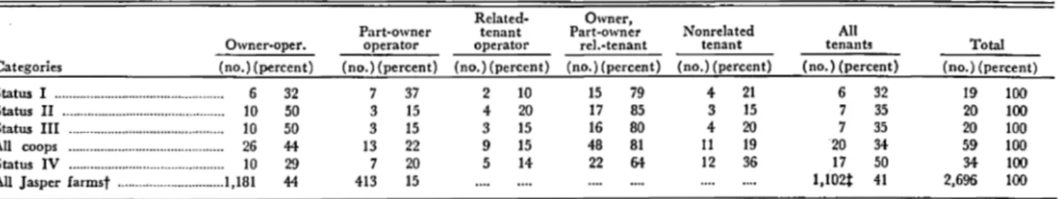
TABLE 4. STATUS OF FARMS AS RELATED TO FARM SIZE AND SIZE DISTRIBUTION.*
Average Distribution of farms by size
size of 50·99 100.179 180-259 260 and over Category
farm in (no.)(p.r- (no.)(per. (no.)(per- (no.)(per·
acres c.ent) cent) cent) cent)
Status I ... 208 3 16 5 26 5 26 6 32
Status II ... 224 0 0 7 35 6 30 7 35
Status III ... 216 3 15 3 15 9 45 5 25 All coops ... 216 6 10 15 25 20 33 18 31
Status IV ... 172 6 18 15 44 11 32 2 6 *Chi square test of independence was significant at the 97'percent level.
The average size of sample farms in categories I II and III (district cooperators) is 216, or 44 acres larger than the average of 172 acres for the farms in Status IV (noncooperators). These data indicate that farms of district cooperators have a definite tendency to be larger in total acreage than the farms of noncooperators. These findings indicate that districts must eventually recognize that certain adjustments may be necessary to bring smaller farms into the district program. Not only does the district encounter special resistances charac-terizing small farmS", but also the extent of soil exploita-tion on such farms may be quite out of proporexploita-tion to the acreage. Remedial measures for this and other dis-trict problems are discussed in later sections.
EFFECT OF FARM: SIZE ON APPLICATION OF PRACTICES
. Despite its effect on th~ initiation of farm planS", farm size does not appear to mfluence cooperators' compli-ance with district land-use recommendations. In other words, there is no significant difference in the propor-tion of farms with particular acreages in the three cate-gories of cooperators. However, since none of the coop-erating farms in Jasper district are under 50 acres in size and all but six, or 10 percent of the cooperating fa~~s are over 100 acres in size, it is, perhaps, not sur-pnsmg that acreage ceases to be an important limiting factor within this group. It might be noted that of these six farms under 100 acres in size, three, or 50 percent are from category III (i.e., unsatisfactory coop-erators).
OWNERSHIP-INTEREST OF FARM OPE.RATOR
Statistical tests of independence of the data in table 4 of the previous section concerning plan status and size of farm are to some extent confounded by a second fac-tor,. "ownership-int;r~st of operator."31 Farm operators havmg an ownershlp-mterest are apparently more likely to be cooperators than are tenants unrelated to their landlords. On the other hand, tenant-operated farms ten?, on the average, to be large in acreage, a factor which seems to favor participation in the district program.32
The following are possible reasons why the objectives of the district are more likely to be achieved on a farm in which the operator has an ownership interest. Where the farm is owner-operated, management decisions are
"Included in thi~ classification are farms operated by owners, part-owners
and sons Or sons-ln·law of the owner. .
~'Aceording to the 1954 U.S. Census of Agriculture, tenant-operated farms
m Jasper County averaged 181 acres in size as compared with 121 acres (or owner-operated farms. U.S. Censu, of Agriculture: 1954.