Relation between Ecological-Range Condition and Propor-
tion of Soil-Surface Types
RICHARD E. ECKERT, JR., FREDERICK F. PETERSON, AND J. TIM BELTON
Different kinds of A-horizon soil-surface types occur on loess- mantled xerollic Orthids and Argids in the Intermountain area. Four soilaurfnce types were identified on sites with potential vege- tation of Wyoming big sagebrush [Arteru&&
tridentutu wyomin-
gensis
Reetle] and Thurber needlegrass [St&m thurberiana Riper]. These surfaces occupy diierent microtopographic positions and have diierent morphologies and chemical and physical properties. This study relrtes differences in the cover of these soil-surfacetypee to ecological-range condition on sites of similar potential. Propor- tion of the surface type found under shrub or bunchgrass cover varies with range condition. More of the surface associated with shrub cover is found on low condition sites because of greater sagebrush cover. More of the surface associated with bunchgrrss cover is found on high condition sites because of greater grass cover. Proportion of the surface types found in the interspace between shrubs also varies with range condition. High condition sites have a greater cover of the soil surface associated with bunch- grass cover and of the soil surface with cryptogam-stabilixed microrelief. Conversely, low condition sites have essentially none of the soil surface associated with bunchgrass cover but a large amount of the soil surface with little microrelief. Results are inter- preted in terms of watershed stability and natural revegetation potenthtl.Various ecological sites in the Intermountain area occur on xerollic Orthids and Argids. The A horizons of many of these soils have formed in a thin loess mantle and have distinctive morpholo- gies determined by their parent material, their microtopographic position, and recent vegetation. This loess originated from sedi- ments deposited in large Pleistocene lakes and subsequently exposed to wind transport as the lakes dried (Young and Evans
1986). In Nevada, the area leeward of these former lakes have soils that commonly are capped with loam, very fine sandy loam, or silt loam textured surface soils. This area is informally called the Humboldt Loess Belt and comprises about 8 million ha in central and northern Nevada and extends into southeastern Oregon,
Authors are range scientist, USDA/ ARS, 920 Valley Road, Rcno, Nev. 895 12; soil scientist, Dep. of Plant Science, Univ. of Nevada, Reno 89557; and former graduate student, Dep. of Range, Wildlife, and Forestry, Univ. of Nevada, Reno 89512. Belton is currently a range conservationist, USDA/F& Sattgus Ranger District, Saugus, Calif. 91350.
This research is the result of cooperative investigations of the USDA-ARS and the Nevada Aar. Exo. Sta. and was funded in Dart bv the USDI-BLM.
Manu&ipt accepted 26 December 1985: .
A slightly depressed or fiat ares at the lowest microtopographic elevation and surrounded by coppices, coppice benches, or intercoppice microplains. Absent in some situations).
JOURNAL OF RANGE MANAGEMENT 39(5), September 1966 409
southern Idaho, and western Utah.
Four distinctive soil-surface morphological types of A horizons are found on fan piedmonts and basin floors in the Wyoming big sagebrush [Artemisiu tridentuta wyomingensis Beetle&grass vege- tation types in the Humbolt Loess Belt (Eckert et al. 1977) (Fig. 1). These soil-surface types are closely related to their microtopo- grapic position. A schematic cross-sectional diagram and descrip- tion of these microtopographic positions are presented in Figure 2 and Table 1, respectively. Similar surfaces have been recognized by Hugie and Passey (1964), Schlatterer (1968), and Stuart et al. (1971,1973). Postulated genesis of these surface horizons and their morphological attributes such as polygon shape, morphology, vesicularity, polygon microrelief, and surface cracks between polygons have been described (Eckert et al. 1977). Texture, organic matter, bulk density, modulus of rupture, and porosity characteris- tics of these soil surfaces were described by Wood et al. (1978). Eckert et al. (1978), Stephens (1980), and Wood et al. (1982) have shown that these morphological and physical properties can affect plant and hydrologic responses to rangeland improvement and management practices.
Table 1. Surface soil morphologiul types and their microtopogrspbk positions.
Surface soil morphological type
Micro-
topographic Description of microtopographic position position
I
II
Coppice
Coppice bench
III
IV
Intercoppice microplain
Playette
A semi-conical form, the highest microtopographic elevation.
A flattish or gently sloping area next highest to the coppice, and higher than any adjacent intercoppice or playette, if the latter occur.
This study describes the relation between the area1 proportions of these soil-surface types and ecological-range condition. Results are interpreted in terms of watershed stability and natural revege- tation potential.
Description of Soil-Surface Types
Typically, the Type I and II surfaces have from 1 to 4% organic matter, a soft or only very slightly hard consistence, a very fine subangular blocky structure, a dry-soil infiltration rate of up to 7 cm/hour, a sediment-production potential of as much as 160 kg/ha, and lack of significant crusts with vesicular porosity (Blackburn 1975, Eckert et al. 1978). The Type I surface is almost always associated withcoverofestablishedvegetation onacoppice dune that accumulated under a shrub (mostly Wyoming big sage- brush in this study) or bunchgrass canopy. Type I surface is formed of round-topped, small polygons that are separated by relatively wide, trench-like, cracks and the surface is commonly covered with litter. The Type II surface is found most commonly as a margin around a Type I coppice dune. The Type II surface has pinnacled, small polygons separated by trench-like cracks. Cryptogams such as lichens and moss [Torfula ruralis (Hedw.) Gaertn., Meyer and Scherb.] stabilize this surface. Water rapidly infiltrates into Type 1 and I1 surfaces during heavy rain or snowmelt.
Typically, the Type III and IV surfaces have less than 1 Yo organic matter and form durable crusts after wetting and drying cycles, These crusts have prominent vesicular pores and may be either massive or weakly platy. Crusts dry to slightly hard, or hard consistence and have a dry-soil infiltration rate of up to 4 cm/ hour and a sediment-production potential of as much as 400 kg/ ha (Blackburn 1975, Eckert et al. 1978). The Type III surface forms on the short, very gentle slopes, or “microplains,” that occur between and around the coppicedunes and benches on which the Type I and II surfaces occur. These microplains have also been called “shrub interspaces.” The Type III surface has flat-topped, moderately- large polygons separated by narrow cracks. The Type IV surface has flat-topped, very large polygons separated by narrow cracks. Type III and IV surfaces are mostly barren, except for partial cryptogam cover on polygons or around polygon margins. During a heavy rain or snowmelt, water runs over the Type III surface and stands on the Type IV surface, and saturates the upper few cen-
Fig. 1. Example of soil-surface rypes: Type Isurfoce under the shrub and covered with moss and liner; Type IIsurface in lower left ofphotograph wirh smollpinnocledpolygonssepornted by wenched cracks md srobil- ized by cryprogom crust; and Type III surface in lower righr of phoro- graph with large, fir polygons seporared by narrow cracks.
timeters of both for short periods.
Methods
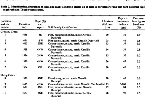
The inference technique described by Tueller and Blackburn (1974) was used to choose study areas. This technique assumes that it is possible to select sites with similar enough soils, elevations, slopes, and exposures so that site potential is similar. Sixteen sites in northern Nevada were selected for this study. Nine sites are in the Sheep Creek Range north of Battle Mountain and 7 are in the Crowley Creek area of the Montana Mountains northwest of Orovada. Soils (Table 2) and remnant vegetation suggest that all sites have the potential to produce a similar kind and amount of vegetation. Therefore, differences in current vegetation and soil- surface morphological types can be interpreted as reflections of variations in management history and resultant range condition rather than as reflections of individual site factors or differences in
M
c
El
M
---
p
rg
.-b-h-,c
M
%M
c
M
Fig. 2. Schematic cross-secrional diagram of the microro~ogrophicpositions of the 4 surface-soil types, including bunchgross Type I #r-l), ossociored wbhgentlysloping, sholfowlyloess-mnnrledxerollic OrrhidsondArgids ofthe Humboldr Loess Belr. Microropogrnphiepositionsore, C= coppice, B- coppice bench, M= inlercoppice microplain, P =plqerre. Verricalscole is somewhat exaggerated. Type Ilr litter covered. Circles indicare vesicles in crusfs (A Iv].
site potential. This argument is based on 2 main points.
(1) The kinds of soils at the study sites previously have been considered to have Wyoming big sagebrush-Thurber needlegrass [St&u thurberiuna Piper] potential vegetation. The soils, as identi- fied at the Family level (Table 2), are among those correlated with the Loamy 8-10” and Droughty Loam 8-10” Range Sites described in the Ecological Site Descriptions for the Humboldt Area-MLRA 24 (USDA 1982). These are the only 2 range sites with Wyoming big sagebrush the dominant shrub and Thurber needlegrass the dominant grass that are identified in this Resource Area for gentle slopes and with the kinds of soils that occur at our study sites. Annual production for these range sites is estimated to differ by only 100 to 150 kg/ ha. Blackburn et al. (1968) described a big sagebrush-Thurber needlegrass habitat type for the same area of the Montana Mountains sampled in the present study. Also, in southern Idaho where soils and vegetation patterns are similar to those in our study areas, Hironaka et al. (1983) described only one habitat type with Wyoming big sagebrush the dominant shrub and Thurber needlegrass the dominant understory grass.
(2) Those soil properties commonly considered to cause differ- ences in site potential are either very similar among sites, or where different, show no regular relation to current range condition. The soil Family identification, site and soil profile characteristics, basal area of decreaser bunchgrass, and range condition class for each study site are given in Table 2. The similarities among soils are marked. All are Aridisols and in Xerollic subgroups, therefore all sites should have about the same soil water regime. All have mesic soil temperature regimes. All have ochric epipedons with sandy loam, very fine sandy loam, or silt loam textures. Because of the
thin loess cap that blankets the area, a relatively high content of very fine sand and coarse silt in the A horizons lends very similar physical behavior to these surfaces as they wet and dry to form characteristic surface morphologies. None of the sites have surface textures of the sand, loamy sand, or clay classes that are sometimes related to vegetation changes or that cannot support the morpho- logical features of the soil-surface types studied here. There are also obvious differences in various soil and site factors among loca- tions. To test the possible effects of differences in these factors on range condition, simple correlations were made between several of these factors and range condition as estimated by basal area of decreaser bunchgrasses. No significant correlation was found between range condition class and elevation, depth to duripan or bedrock, thickness of the A horizon, slope, or aspect (r2 values <O. 1). Table 2 also shows that sites with the same particle size class are in quite different range condition classes.
This evidence strongly indicates that these soil and site factors have produced a very similar potential vegetation on all sites. Therefore, it seems reasonable to attribute differences in ecological- range condition of existing vegetation and related soil-surface types to different management histories.
Thurber needlegrass is the main decreaser species on all sites at each of the 2 study areas. Wyoming big sagebrush, Sandberg bluegrass [Pou sundbergii Vasey], and squirreltail [Situnion hys- rrix(Nutt.) J.G. Sm.] are the principal increaser species; cheatgrass [Bromus tectorum L.] is an invader species. Important perennial forbs are desert phlox [Phlox u~stromonfunu Cov.], tapertip hawksbeard [Crept’s ucuminutu Nutt.], Stansbury phlox [Phlox srunsburyi Hel.], milkvetch [Asrrugulus spp. L.], wild onion Table 2. Idcntlfic8tion, properties of soils, md range condition ckssea on 16 sites in northern Nevada that have potential vegetation of Wyoming big
segebrusb and Thurber aeedkgms.
Location and site number
Elevation (m)
Depth to Decreaser
Slope (%) A horizon duripan or bunchgrass Range
and thickness bedrock basal area condition
aspect Soil Family identification (cm) (Cm) (%I class
Crowley Creek 1 2 3 4 5 6 7
Sheep Creek 8 9 10 11 12 13 14 15 16
1,448 3E
1,451 1sw
1,463 2NE
1,518 4NW
1,524 3NW
1,530 4NW
1,564 4SE
1,576 4NE
1,615 4NW
1,637 4SE
1,667 3NE
1,670 3NW
1,682 3NW
1,701 3sw
1,704 2NW
1,722 2NW
Fine, montmorillonitic, mesic Xerollic Durargid
Fine-loamy, mixed, mesic Xerollic Durorthid Coarse-loamy, mixed, mesic Xerollic
Durorthid
Coarse-loamy, mixed, mesic Xerollic Durorthid
Coarse-loamy, mixed, mesic Xerollic Durorthid
Coarse-loamy, mixed, mesic Xerollic Durothid
Coarse-loamy, mixed, mesic Xerollic Durothid 30 25 13 14 13 26 20
Fine-loamy, mixed, mesic Xerollic 20 Durargid
Coarse-loamy, mixed, mesic Xerollic Camborthid IS Fine, montmorillonitic, mesic, Xerollic 29
Durargid
Fine, montmorillonitic, mesic Xerollic 28 Durargid
Fine, montmorillonitic, mesic Xerollic 28 Durargid
Fine-loamy, mixed, mesic Xerollic Durargid 33 Coarse-loamy, mixed, mesic Xerollic 10
Durothid
Coarse-loamy, mixed, mesic Xerollic Durorthid 27 Fine, montmorillonitic, mesic Xerollic 19
Haplargid 56 46 39 31 35 47 45 65 >loo 84 90 65 64 35 0.9 0.8 0.0 2.8 0.2 2.3 0.0 0.2 1.3 2.5 1.1 0.1 5.0 Mid-seral Mid-seral Early-seral Late-seral Early-seral Late-seral Late-seral Early-seral Early-seral Mid-seral Late-seral Mid-seral Early-seral Potential- natural community Early-seral Potential- natural community
c
[ANium spp. L.], and fleabane [Erigeron spp. L.]. Many annual forbs are present on disturbed sites. Elevation of the sites ranges from 1,448 to 1,722 m, and slope varies from 1 to 4%.
Vegetation on each study area was stratified on the basis of abundance of Thurber needlegrass. Within each stratum, a study site of 30 X 100 m was randomly located in a homogenous stand of vegetation. Canopy cover of shrubs and surface cover soil-surface types were estimated by the line-intercept method (Canfield 1941) on 10 randomly selected 30-m transects. In addition to the 4 soil surface types described earlier, a bunchgrass-Type I surface was
also identified (Figs. 2 and 3) and measured separate from the shrub-Type 1 surface. Recognition of a bunchgrass-Type 1 surface is important from a hydrologic standpoint because the soil under bunchgrass has a high infiltration capacity (Blackburn 1975). Since the Type IV surface was found only on 2 of I6 sites with an average cover of less than 3% on these 2 sites, data for this surface were combined with those for the Type III surface for presentation of results. Basal-area cover of perennial bunchgrasses was estimated with the aid of guide rings of known areas on IO, 30 X 60 cm microplots placed systematically along each transect line.
Significant (PzZO.05) differences among the various vegetation and soil-surface type attributes were determined by analysis of variance and Duncan’s multiple range test.
Results and Discussion
Vegetation on each of the 16 study sites was placed in I of 4 ecological-range condition classes based on significant differences in the basal-areacover of decreasergrasses, mainly Thurber needle- grass (Table 3). Two sites have the potential-natural community (PNC); 4 sites are in late-seral condition; 4 sites are in mid-seral condition, and 6 sites are in early-seral condition. Mean basal area of Thurber needlegrass (2.7%) on sites in late-seral condition is similar to that found on high condition sites representing the Wyoming big sagebrush-Thurber needlegrass habitat type in southern Idaho (personal communication, M. Hironaka). The Nevada sites with a greater mean basal cover of needlegrass (4.6%) may represent an even higher condition class than that described in Idaho. The range condition terminology used is that proposed by the Range Inventory Standardization Committee (1983). PNC, and late-, mid-, and early-seral classes are equivalent to the excel- lent, good, fair, and poor classes, respectively, as defined by the Soil Conservation Service (1976) and used to compare present vegetation with potential vegetation.
The proportion of each soil-surface type varies with ecological- range condition (Table 3). Total cover of Type I surface is related to the cover of shrub-Type I and bunchgrass-Type 1 surfaces and is greatest on sites in either early- or late-seral condition. The cwer of bunchgrass-Type I surface is from 3 to 9 times greater on sites with PNC than on sites in lower seral stages. The basal area of decreaser grasses and bunchgrass-Type I surface varies concomitantly with range condition, hut basal area of increaser grasses does not vary with range condition. This response suggests that formation of a hunchgrass-Type I surface is more dependent on the presence of decreaser grasses than on increaser grasses. Longevity of decreaser grasses, amount of litter deposited, litter quality, and root charac- teristics may be responsible for development and maintenance ofa hunchgrass-Type I surface.
Bunchgrass-Type I, Type II, and Type III surfaces vary more with range condition than do shrub-Type I or total-Type I surfaces (Table 3). Not only does the extent of the former surfaces vary with range condition, hut so does the spatial distribution pattern. Pre- vious studies of other sites in early-seral condition (Eckert et al.
Table 3. Mean vegetation and soil-surface characteristics associated with 4 range condition classes on sites in northern Nevada with potential vegetation of Wyoming big sagebrush and Thurber needkgrus.
Ecological-range condition and number of sites
Potential natural
Vegetation characteristics Soil-surface characteristics
(% Cover) (% surface cover)
Qnow, Basal, Basal, Basal, tota,
big decreaser increaser perennial Shrub- Bu”AgrUs- Total-
sag&r”& grasses grasses grasses TYPC I Type 1 TYPO I Type II Type 111
community (2) 16b’ 4.6a 2.6 a 7.2 a 21 b 9a 30 at?
Late-seral(4) ISb 2.1 b 3.3 a 6.0 ab 32 a 3b
Mid-seral(4)
35 a
22 ab I.llc 3.3 a 4.3 b 29 a I bc
Early-seral(6)
30 b
26a 7’ d 2.1 a 2.2 c 33 a Tc 33 a
‘Means in the same FOlUrn” followed by different letters are significantly different (lio.OS) as dCtCnni”Cd by Duncan’8 multiple range at. >T = <I% basal wea or soilrurfaee eovsr.
61 a 44b 45 b 32 c
9c 21 b 25 b 35 a
1977) reported the Type I surface only on coppice dunes under negative hydrologic and revegetation characteristics associated shrub canopies, and the Type II surface only adjacent to the Type I with the Type III surface also should have about maximum expres- surface(Fig. 2) and not on the microplains of the shrub interspaces. sion because of the large proportion of this surface type on sites in In the present study, basal cover of bunchgrass in the interspaces early-seral range condition. Even on sites in early-seral condition, among shrubs is greater on sites in PNC and late-seral condition however, Type I and II soils still cover 65% of the surface and than on sites in lower range condition. Since each bunchgrass plant provide a number of possible microsites for seedling establishment has a Type I surface at its base, this bunchgrass-Type I surface is and natural revegetation. Unfortunately, decreaser grasses are very more extensive in the interspaces of high condition sites than of low scarce or lacking and produce little or no seed to utilize the avail- condition sites. Also on high condition sites in the present study, able microsites. Even increaser grasses lack vigor and have reduced the Type II surface forms patchy, cryptogam-stabilized areas on seed production due to heavy grazing and competition from sage- the microplains in shrub interspaces. Less of the Type II surface brush. These vegetation and soil-surface conditions appear to per- occurs on the microplain of low condition sites. petuate sagebrush, cheatgrass and annual forbs-a condition we
see all too often in the Intermountain area.
Data Interpretation and Implications
Conclusions
Based on the data presented, we propose a scenario of how
proportions of soil-surface types might change as range condition On rangelands in northern Nevada with a potential vegetation of varies from PNC to early-seral condition and how these changes Wyoming big sagebrush and Thurber needlegrass, sites managed may affect the hydrologic and natural revegetation characteristics to maintain PNC should have the most favorable watershed
of a site. characteristics due to a large proportion and even distribution of
Sites with PNC have a surface covered mostly with shrub-Type soil surfaces with favorable hydrologic traits. Also, ifan opening in I, bunchgrass-Type I, and Type II surfaces. These soil surfaces the community occurs, seed of desirable species should have a large have favorable hydrologic characteristics because of fine-subangular number of microsites available for potential plant establishment blocky or weak platy structure and few vesicular pores (Loope and and perpetuation of the species.
Gifford 1972, Blackburn 1975). Their common depression micro- Sites in late- and mid-seral range condition also have a large sites and friable soil may also favor natural revegetation (Harper et number of favorable microsites due to microrelief of the soil sur- al. 1965, Eckert et al. 1978, Stephens 1980). Since bunchgrass Type faces. Grazing management should be designed to enhance vigor I and Type II surfaces occur on microplains in shrub interspaces as and seed production of desirable species in order to increase the well as on coppice dunes under shrubs and on coppice benches density and widen the spatial distribution of plants of these species. around shrubs, beneficial hydrologic and revegetation effects are Watershed quality has been somewhat diminished because of the spread more or less uniformly across the site. Furthermore, sites reduced extent and uneven distribution of soil surfaces with favor- with PNC have a very small coverage of Type III surface with its able hydrologic characteristics and increased amount of the soil unfavorable hydrologic and revegetation characteristics that are surface with unfavorable hydrologic characteristics.
due to massive structure and smooth surface crusts with vesicular Sites in early-seral condition have a few or no decreaser grasses,
porosity. a dense cover of big sagebrush, and a large proportion of a soil
On sites in late- and mid-seral condition, cover of total Type I surface with both unfavorable hydrologic qualities and with mic- surface is about the same as on sites with PNC because shrub rosites that appear to encourage establishment of sagebrush, canopy cover is similar. Therefore, hydrologic and revegetation cheatgrass, and weedy annual forbs. These sites cannot be characteristics associated with shrub-Type I surface are similar to improved by grazing management alone. Rather, brush and weed that on sites with PNC. Bunchgrass-Type I surface is less than on control, and seeding with adopted species are required to increase sites with PNC because basal cover of decreaser grasses is less. forage production and improve watershed conditions.
Cover of Type II surface also is less because of the physical destruc-
tion of this rough, cryptogam-stabilized surface by livestock hoof
Literature Cited
action (Anderson et al. 1982). After repeated heavy trampling this Anderson, D.C., K.T. Harper, and R.C. Holmgren. 1982. Factors influenc-
surface is crushed into a smooth Type III surface. With less ing development of cryptogamic soil crusts in Utah deserts. J. Range bunchgrass-Type I and Type II surfaces, the proportion of Type III Manage. 35:180-185.
surface is greater and fewer sites for rapid infiltration occur in the Blackburn, W.H., P.T. Tueller, and R.E. Eckert, Jr. 1968. Vegetation and interspaces. Water moves more rapidly over a smooth crusted soils of the Crowley Creek Watershed. R 42. Univ. of Nevada College of surface with vesicular pores and, with lower infiltration, runoff and Agr., Reno.
sediment-production potential should increase. In addition to Blackburn, W.H. 1975. Factors influencing infiltration rate and sediment unfavorable hydrologic characteristics, unfavorable revegetation production of 11:929-937. semiarid rangelands in Nevada. Water Resources Research
characteristic for desirable species also are associated with the Canfield, R.H. 1941. Application of the line interception method in sam- microrelief and morphological features of the Type III surface pling range vegetation. J. Forest. 39:388-394.
(Stephens 1980). In spite of these undesirable changes, secondary Eckert, R.E., Jr., F.F. Peterson, M.K. Wood, and W.H. BIaebburu. 1977.
succession should still be possible on sites in late- and mid-seral Properties, occurrence, and management of soils with vesicular surface range condition because these sites have remnants of decreaser horizons. Final Report, Contract 5.20~CTS-(N) between the USDI, grasses and Type I and II soils cover more than 75% of the surface. Bureau of Land Management and the Nevada Agr. Exp. Sta.
Thus a network of microsites is available for potential establish- Eekert, R.E., Jr., M.K. Wood, W.H. BIackbum,F.F. Peterson, J.L. Ste- ment of new plants of desirable species provided grazing manage- phens, and M.S. Meurisse. 1978. Effects of surface-soil morphology on ment maintains plant vigor and seed production by these species. Proc. First Internat. Range. Cong., Denver, Colo. improvement and management of some arid and semiarid rangelands. On sites in early-seral range condition, sagebrush canopy cover, Harper, J.L., J.T. WiUiams,and G.R. Sanger. l%S.The behavior of seed in
cover of shrub- Type I, total-Type I, and Type III soil surfaces are soil. I. The heterogeneity of soil surfaces and its role in determining the
generally greater than on sites in higher range condition. Bunch- establishment of plants. J. Ecol. 53:273-286.
grass-Type I surface is much less extensive because of a lack of Hironaka, M., MA. Fosbeq, and A.H. Winward. 1983. Sagebrush-grass decreaser bunchgrasses. Cover of Type II surface is further reduced habitat types in southern Idaho. College of Forestry, Wildlife, and by trampling. All of the favorable hydrologic and revegetation Range Science, Univ. of Idaho, Moscow. Bull. No. 35.
characteristics associated with the shrub-Type I surface should Hugie, V.K., and H.B. Passey. 1964. Soil surface patterns of some semiarid have about maximum expression because of the large proportion soils in northern Utah, southern Idaho, and northeastern Nevada. Soil of this surface type on early-seral sites. Conversely, all of the Sci. Sot. of Amer. Proc. 28:786-792.
Loope, W.L., and G.F. Gifford. 1972. Influence of a soil microfloral crust on select properties of soils under pinyon-juniper in southeastern Utah. J. Soil and Water Conserv. 27:&l-167.
Range Inventory Stmdardimtion Committee. 19g3. Guidelines and termi- nology for range inventories and monitoring. Sot. for Range Manage., Denver, Colo.
SeMattarer, E.F. 19611. Establishment and survival of three native grasses under natural and artificial conditions. Ph.D. Thesis, Univ. of Idaho, Moscow.
Stephens, J.L. 1980. Seedling emergence on vesicular crusted surfaces as affected by artificial and natural cattle trampling. M.S. Thesis, Univ. of Nevada, Reno.
Stuart, D.M., GE. Scbuman, and A.S. Dylia. 1971. Chemical characteris- tics of coppice dune soils in Paradise Valley, Nevada. Soil Sci. Sot. of Amer. Proc. 35607-611.
Stuart, D.M., R.E. Kckert, Jr., A.S. DyUa, and GE. Scbuman. 1973. Seeding coppice dune areas in northern Nevada. Agr. Exp. Sta., Univ. of Nevada, Reno and USDA/ARS-WR Tech. Bull. T II.
Tucller, P.T., and W.H. Blackbum. 1974. Condition and trend on the big sagebrush/ needle and thread habitat type in Nevada. J. Range Manage. 27:36-40.
USDA. 1976. National Range Handbook. Soil Conservation Service, Washington, D.C.
Wood, M.K., W.H. Blackburn, R.E. Eckert, Jr., and F.F. Peterson. 1978. Interrelations of the physical properties of coppice dune and vesicular dune interspace soil with grass seedling emergence. J. Range Manage. 31:189-192.
Wood, M.K., R.E. Eckert, Jr., W.H. Blackbum, and F.F. Peterson. 1982.
Influence of crusting soil surfaces on emergence and establishment of crested wheatgrass, squirreltail, Thurber needlegrass, and fourwing salt- bush. J. Range Manage. 39282-287.
Young, J.A., and R.A. Evans. 1986. Erosion and deposition of fire sedi- ments fromplayas. J. Arid Environ. l&103-115.