IOP Conf. Series: Earth and Environmental Science 18 (2014) 012126 doi:10.1088/1755-1315/18/1/012126
Mapping Perception o f Community Preparedness towards
Flood in Muar River, Johor Malaysia
T A Tengku Asmara1,3 and A N Muhamad Ludin2
'Student, Centre for Innovative Planning & Development,Faculty o f Built Environment Universiti Teknologi Malaysia
2Professor Centre for Innovative Planning &Development,Faculty o f Built Environment Universiti Teknologi Malaysia
E- mail: tengku.yon@ gm ail.com
Abstract. The top-bottom approach of disaster management framework is used in many countries, including Malaysia. This approach allows the top management level to make decisions and implement strategies. Contribution from the bottom management level especially the communities often are not being taken into consideration and sometimes, totally being ignored. This study aims to analyse the level of preparedness of community engagement towards flood disaster management. 100 households from Segamat District were randomly selected and interviewed. Assessment of their perception towards flood preparedness is explored by means of Likert scale analysis and GIS tools. This paper discusses the results of community preparedness towards flood disasters management. The findings revealed that community are better prepared and independent towards the disasters and thus there is a need to be considered. Community engagement in the management is crucial and thus, this study suggests an enhancement of the current approach of management. Experiences with disasters, knowledge awareness towards the disasters risks are the reasons the importance in community engagement towards disaster management.
1. Introduction
The worst flood disaster in 100 years hit the district of Segamat, Johor, Malaysia on 12 January 2007 and since then; the event occur at almost each year especially during monsoon season and this has caused lots o f damages including death. In Malaysia, flood disasters management is managed by the National Security Council (NSC) working together with multi-disciplinary agencies. Department of Irrigation and Drainage (DID) is one of the important agencies dealing with flood mitigation strategies but they put their focus mainly on the structural approach. Structural approach is greatly influenced by engineering approach; therefore, the overall flood management has limited success [1]. Apparently, rather than only focusing on a single approach, the responsible authorities should look into and incorporate of other flood management mechanisms that could be integrated with the main approach. Historically top down approach o f flood management has dominated the disaster management field [2] in many countries including Malaysia. However, to meet the current needs and demand from flood disasters vulnerable community, the current approach needs to be transformed. This transformation needs to be implemented as top down approach of flood management has often failed to address local needs, ignoring the potential o f the native resources and capacities, and increased the community’s vulnerabilities towards disasters [3]. In this paper, assessment of the community perception towards existing flood management mechanisms is carried out through
3 To whom any correspondence should be addressed
IOP Conf. Series: Earth and Environmental Science 18 (2014) 012126 doi:10.1088/1755-1315/18/1/012126
mapping o f their preparedness level. The maps will provide guidance to the responsible authorities in identifying the level o f vulnerable communities spatially. These identifications help the authorities in planning their strategies in reducing the flood disasters risk and thus, creating a safer environment [4]. The community perception towards flood management also creates an opportunity for the responsible authorities to improve the current management approach and at the same time, improve the capacity building o f the community to be better prepare for future occurrence of flood disasters [5].
2. Methodology
2.1Research design
Generally, disaster management studies consider several indicators including demography, socio economic, awareness level, warning system, community preparedness and others. However, this paper focuses on community perception towards flood disaster preparedness management. Also, this paper seeks to explore their intention strategies towards future flood disasters occurrence.
Figure 1. Research design in mapping perception o f community preparedness.
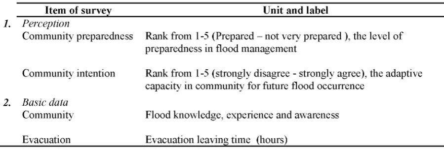
Figure 1 illustrates the overall flow of evaluation process of mapping perception on community preparedness. Inverse Distance Weighting (IDW) analysis in Geographic Information System (GIS) is used for analyzing data. IDW is one of regression methods to explore spatial correlation that determines if the values of the community perceptions are interrelated. IDW determines cell value using a linear weight combination set o f sample points. The weight assigned is a function o f the distance of an input point from the output cell location [6]. The greater the distance, the less influence cell on the output value. Sample points for this paper are as shown in Table 1 which categorized as perception.
Table 1. Item o f survey for respondents in Segamat, Johor, Malaysia.
Item of survey Unit and label
1. Perception
Community preparedness Rank from 1-5 (Prepared - not very prepared ), the level of preparedness in flood management
Community intention Rank from 1-5 (strongly disagree - strongly agree), the adaptive capacity in community for future flood occurrence
2. Basic data
Community Flood knowledge, experience and awareness
Evacuation Evacuation leaving time (hours)
2.2Research tools and instrument
IOP Conf. Series: Earth and Environmental Science 18 (2014) 012126 doi:10.1088/1755-1315/18/1/012126
5 - Very Prepared; 4 - Prepared; 3 - Not very prepared; 2 - Not very prepared; 1 - Don’t know (preparedness level)
Based on the scores obtained from the interview, average (means) amounts which can be defined as the equal amounts for the positive and negative positions [7] are calculated. In order to support the findings, basic data including community flood knowledge, experience, awareness and their evacuation leaving time are also collected. Expectation findings expected to be achieved in this paper in this papers are; 1) Identification o f the differences o f community perception towards flood disaster management taken by several different groups including household, community, local government and other responsible authorities 2; Exploration of community adaptive strategies towards future flood disasters occurrence and their dependency level towards responsible authorities in flood disaster management 3) Discussion on the reliability o f community perception mapping method for future action of disaster management. Case study and sampling carried out at Segamat district. In 2006 Segamat which is one of the districts extremely affected has become an “island” after it was cut off by floodwaters [8]. Therefore, Segamat district is selected as case study for this paper as it is frequently hit by flood disaster and its communities can be considered as highly vulnerable. 100 households from Segamat District were randomly selected and interviewed. Figure 2 illustrated data sampling gathered from respondents consider for three circumstances which are respondents that are experience before (A) , during (B) and aftermath (C)flood event.
3. Findings and discussions
Evaluation of community perception o f their preparedness level towards flood disaster is evaluated by means of Likert analysis. The findings o f the community perception towards flood management are as shown in Table 2. Obviously, household is prepared with a score o f 4.04 towards future flood
disasters occurrence. With a score of 3.96, community is also scaled as prepared. These two groups are the most vulnerable groups towards flood disasters and therefore, high preparedness level is crucial in order for them to reduce the expected risks.
Table 2. Perception of preparedness level of respondent groups towards future flood disasters
Figure 2. Distribution o f data sampling collected in Segamat district.
occurrence.
Group Score Measurement Scale
Household Community Local Government
4.04 Prepared (4.5-3.5) 3.96 Prepared (4.5-3.5)
IOP Conf. Series: Earth and Environmental Science 18 (2014) 012126 doi:10.1088/1755-1315/18/1/012126
National Security Council 1.85 Not prepared at all (2.5-1.5) Utilities service providers - including roads, 1.22 Don’t know (1.5-0.5) electricity, telecommunications etc
Social welfare organizations - red cross, 3.05 Not very prepared (3.5-2.5) political parties, emergency response team and
etc
The high preparedness level scored by them reveals that they have positive perception towards the applied flood management concept in the district o f Segamat. More to the point, it is surprising to see that social welfare organization and local government which are responsible authorities in helping the community towards flood disasters are consider very prepared for future flood disasters occurrence. Apparently, this is because they are not the one who essentially had the hands-on experience with flood disasters.
Groups Household
Community Local Government Social welfare Utilities service providers
National Security Council Average Score
0 1 2 3 4 5
Graph 1: Perception of preparedness level o f respondent groups towards future flood disasters occurrence
Based on illustration in Graph 1, it is obvious that household and community groups are more prepared towards the future flood disasters occurrence compare with responsible authorities such as local government, social welfare, utilities service providers and NSC. It reveals that they are better prepared, independent and putting less expectation from the responsible authorities in order to deal with the flood disasters. Community adapted the concept of ‘living with flood’ [9,10] through improving their capacity building which are more independent and enhancing community management. One of the strategies implemented by the household and community is the possibility of raising their house floor level as shown in Table 3. This finding is crucial to the responsible authorities as community strategies are not being taken into consideration towards managing flood disasters risks. There is an increasing need for the existing approaches to be reviewed in term o f flood management framework, flood profile assessment and also, standard o f procedure (SOP) for flood evacuation plan. The concept of living with flood adapted by the household and community also disclose that flood management approach is currently shifting towards community based approach. This new approach is way more better compare to the previous approach as the household and community have the hands-on experience, knowledge and awareness towards flood disasters. Therefore, they are supposed to be the main key players in flood management.
IOP Conf. Series: Earth and Environmental Science 18 (2014) 012126 doi:10.1088/1755-1315/18/1/012126
household and community towards flood disasters have been shifted from some people’s business to everyone’s business whereby they are coordinating and integrating with each other in order to evacuate themselves from the flood disasters and thus reducing the expected risks. Perception mapping of the household and community is very crucial because it can actually be part o f the preparedness procedure towards the future occurrence of flood disasters.
Table 3. Household and community intention.
Data Group Score Measurement
Scale Seek information on flood risk in your community
Seek information on things to do to prepare for a possible flood Become involved with a local group to discuss how to reduce fold risk in your community
Increase level of insurance Raise the floor level o f our house
3.30 3.68 3.51
1.00 3.90
Possibly (3 -5) Possibly (3 -5) Possibly (3 -5)
No (1- 3) Possibly (3 -5)
Findings in Table 3 show the score and result o f the household and community intention towards dealing with future flood disasters occurrence. As mentioned earlier, they have adapted the concept of living with flood and thus raise the floor level of their house is one o f their intentions to deal with such disasters. Their intention to do so is due to their hands-on experience with flood disasters which causes lots o f damages and dead to them and thus, enhancing them to be more prepared when dealing with such disasters. Additionally, in dealing with future flood disasters occurrence, the household and community also intended to seek information on flood risk in their community (3.30), information about things to do in preparing themselves for such occurrence (3.68) and they also getting involved with a local group to discuss how to reduce fold risk in their community (3.51). Based on these scores, it can be concluded that responsive authorities should have consider all o f these intentions in order to improve the flood management approach by forming appropriate and effective standard o f procedure (SOP) to the vulnerable household and community. Parallel to this, the responsive authorities should also help the household and community to be more prepared in dealing with the flood disasters and considered integrating them as the main key players in the flood management approach.
4. Conclusion & Recommendation
IOP Conf. Series: Earth and Environmental Science 18 (2014) 012126 doi:10.1088/1755-1315/18/1/012126
Figure 3. (A) Community in high level o f preparedness less evacuation period. (B) Community that depend on responsible agency take more time for evacuate.
References
[1] Chan N.W and Liu P.S 2003 The Malaysian Flood Hazard Management Program Int. J . Emergency managment, vol 1 No.3
[2] Allen K M 2006 Community-based disaster preparedness and climate adaptation: local capacity-building in the Philippines. Disasters 30 81-101
[3] Victoria L P and kurt A M 2006 Community based approaches to disaster mitigation Regional Workshop on Best Practices in Disaster Mitigation 273
[4] Heijmans A 2001 “vulnerability”: a matter o f perception 1 International Work-Conference on “Vulnerability in Disaster Theory and Practice ” organized by Wageningen Disaster Studies, 29/30 June 2001 1-17
[5] Bosher. L 2008 Hazard and the Built Environment : attaining built-in resilience / [6] Childs. C; Interpolating surface in Arcgis Spatial Analysis. ESRI Education Services,
Available http://w ebapps.fundp.ac.be/geotp/SIG /interpolating.pdf
[7] Burns, Alvin; Burns, Ronald 2008 Basic Marketing Research (Second ed.). New Jersey: Pearson Education. p. 250. ISBN 978-0-13-205958-9.
[8] The Star 2011; News article available at
shttp://thestar.com .m y/new s/story.asp?file=/2011/2/1/nation/7914433& sec=nation [9] Trieu T T, Trung N H and Tuan L A; A rticle L ivingW ith Flood In The M ekong.
availablehttp://w w w .m arecentre.nl/people_and_the_sea_5/docum ents/TranThiTrieu.pd f