L E T T E R
Open Access
Estimation of the source process of the
2015 Gorkha, Nepal, earthquake and
simulation of long-period ground motions
in the Kathmandu basin using a
one-dimensional basin structure model
Hisahiko Kubo
*, Yadab P. Dhakal, Wataru Suzuki, Takashi Kunugi, Shin Aoi and Hiroyuki Fujiwara
Abstract
The source rupture process of the 2015 Gorkha, Nepal, earthquake was estimated by the joint kinematic source inversion with near-field waveforms, teleseismic waveforms, and geodetic data. The estimated seismic moment and maximum slip are 7.5 × 10²⁰Nm (Mw7.9) and 7.3 m, respectively. The total source duration is approximately 50 s. The derived source model has a unilateral rupture toward the east and a large-slip area north of Kathmandu with the maximum slip. Using the estimated source model together with a one-dimensional (1-D) velocity basin structure model, long-period (> 4 s) ground motions were simulated at a site located in the Kathmandu basin, where strong
ground motions with predominant components in a 4–5s period were observed during the 2015 Gorkha earthquake.
This simulation demonstrated that the major features of the observed waveforms can be reproduced by our source model and the 1-D basin structure model.
Keywords:The 2015 Gorkha earthquake, Source rupture process, Long-period ground motions in the Kathmandu basin, Joint source inversion, Waveform simulation
Introduction
The 2015 Gorkha earthquake occurred in central Nepal at 11:56 on April 25, 2015, local time (06:11 on April 25, Coordinated Universal Time). The moment magnitude
(Mw) estimated from the centroid moment tensor
(CMT) inversion by the Global CMT (GCMT) Project was 7.9. Based on the source mechanism and hypocen-ter, this event was a thrust-type interplate earthquake between the subducting Indian plate and the overriding Eurasian plate. This earthquake caused strong ground motions across Nepal with a maximum seismic intensity of VIII on the modified Mercalli intensity scale. This earthquake and the following aftershocks killed approxi-mately 9000 people and injured more than 23,000 people. It was the worst natural disaster to strike Nepal since the 1934 Nepal-Bihar earthquake.
The source process of the 2015 Gorkha earthquake has been investigated using various datasets such as near-field waveforms, teleseismic waveforms, and geo-detic data (e.g., Avouac et al. 2015; Galetzka et al. 2015; Grandin et al. 2015; Kobayashi et al. 2015; Yagi and Okuwaki 2015). In general, the resolution of source inversion with near-field waveforms (strong ground motion data or high-rate Global Positioning System (GPS) data) is spatially and temporally high because the near-field waveforms are expected to contain much information on the detailed source process. However, in the case of the 2015 Gorkha earthquake, the distribution of near-field stations was one-sided against the source region and this distribution is expected to reduce the source-inversion resolution or bias the solution. On the other hand, teleseismic stations are globally distributed and teleseismic data have a good azimuthal coverage, although the source-inversion resolution of teleseismic waveforms is generally lower than that of * Correspondence:hkubo@bosai.go.jp
National Research Institute for Earth Science and Disaster Prevention, 3-1, Tennodai, Tsukuba, Ibaraki 305-0006, Japan
near-field waveforms (e.g., Yokota et al. 2011). Add-itional use of geodetic data (static displacements) to-gether with waveform data makes the source inversion more stable (e.g., Wald and Graves 2001). Previous stud-ies have shown that a more reliable source model can be obtained by using combined datasets in the source inver-sion (e.g., Yoshida and Koketsu 1990; Wald and Heaton 1994; Kubo and Kakehi 2013). In this study, therefore, we developed a reliable source model of the 2015 Gorkha earthquake jointly using near-field waveforms, teleseismic waveforms, and geodetic data.
During the 2015 Gorkha earthquake, strong ground
motions with predominant components in a 4–5s
period were observed in the Kathmandu basin, and the waveform comparison between rock and basin sites has shown that one cause of the characteristic waveforms is the site effect of the Kathmandu basin (Galetzka et al. 2015; Dhakal et al. 2016). The ground motions are also attributed to be the source effect because the 4–5s period components were predominant in the observed spectra even at the rock site (Fig. 3 in Galetzka et al. 2015). Thus, for understanding the long-period ground motions in the Kathmandu basin during this earthquake, both source and site effects should be considered. In this study, we investigated how well the long-period ground motions can be reproduced by the source model esti-mated from the source inversion and an available one-dimensional (1-D) underground velocity structure model for the Kathmandu basin. Although the source models of the 2015 Gorkha earthquake have been proposed (e.g., Avouac et al. 2015; Galetzka et al. 2015; Grandin et al. 2015; Kobayashi et al. 2015; Yagi and Okuwaki 2015), the waveform simulation in the Kathmandu basin using the derived source model has never been conducted.
In this study, we first estimated the source process of this event using the kinematic joint earthquake source in-version with near-field waveforms, teleseismic waveforms, and geodetic data. Using the derived source model, we investigated the relationships among fault parameters of the characterized source model of the 2015 Gorkha earthquake and compared them with empirical relation-ships for interplate earthquakes. Because there were few interplate earthquakes in the Himalayan region observed by the modern seismic observation network, it is import-ant to examine whether the 2015 Gorkha earthquake obeys the previous empirical relationships of fault pa-rameters. Then, we discussed its relationship with the interplate-coupling distribution, seismic activity, and past large events. Finally, using the estimated source model together with the 1-D velocity structure model for the Kathmandu basin, we carried out the waveform simulation of long-period (> 4 s) ground motions at a site located in the Kathmandu basin.
Methods
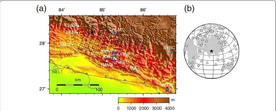
The source process was estimated by the fully Bayesian multiple-time-window source inversion (Kubo et al. 2016). One advantage of this method is that the distribu-tions of model parameters and hyperparameters (e.g., relative weight of smoothing constraint) produced by the fully Bayesian source inversion are useful in evaluating the uniqueness and reliability of a derived model. An-other advantage is that when a non-negative constraint is used, the fully Bayesian source inversion can determine appropriate hyperparameters, whereas a conventional source inversion might not do well. The spatiotemporal smoothing and non-negative constraints for slips were applied following the procedure proposed by Kubo et al. (2016) to obtain a physically reasonable and stable solu-tion. In the source process analysis, we assumed a single rectangular fault model (140 km along the strike × 80 km along the strike, Fig. 1a) with the 293° strike angle refer-ring to the GCMT solution. The dip angle of the fault model was set to 5° to minimize the data-fit residual. The fault model was divided into 160 subfaults of 10 km × 10 km. Because we estimated the weights of the two orthogonal slips for each time window at each subfault under the non-negative constraint, the rake angle of the slip vector for each subfault was allowed a variation from the central rake angle of ±45°. The central rake angle of 108° referred to the GCMT solution. The horizontal loca-tion of the rupture starting point was fixed at the epicen-ter deepicen-termined by the Nepal Seismological Centre (NSC) (84.75° E, 28.24° N). The depth of the rupture starting point was set to 8 km based on the fit of near-field wave-forms. The slip time history at each subfault was repre-sented by a series of six smoothed-ramp functions with a 4.0-s width, each with a 2.0-s lag. The triggering velocity of the first time window of 3.4 km/s was selected to minimize the data-fit residual. Although the amplitudes of the near-field and teleseismic waveforms in the source inversion were normalized by the maximum amplitude at each station, the normalization at each station was not applied to the geodetic data to avoid the instability caused by the low signal-to-noise ratio data with small absolute values (Wald and Graves 2001). The relative weights among the datasets were determined so that the data fit for each dataset is satisfactory.
domain and were band-pass filtered from 4 to 50 s. The time length of the near-field waveforms is 50–60 s, which depends on the record length at each station (starting 10 s before theoretical S-wave arrival). Green’s functions of near-field waveforms were calculated using the discrete wave number method (Bouchon 1981) and the reflec-tion/transmission matrix method (Kennett and Kerry 1979) assuming a 1-D velocity structure model. The 1-D velocity structure model was constructed based on Monsalve et al. (2006), who developed 1-D velocity struc-ture models in east Nepal and south Tibet to relocate earthquakes in these regions.
For teleseismic waveforms, we used P-wave parts of vertical-component broadband waveforms at 45 stations of the Global Seismograph Network (GSN) (Fig. 1b). The instrumental responses were deconvolved from the original recordings to obtain the ground velocities. The observed velocity waveforms were numerically integrated into displacement in the time domain, were band-pass filtered from 4 to 50 s, and were resampled at 5 Hz. The time length of the teleseismic waveforms is 110 s (starting 10 s before P-wave arrival, which was carefully identified by visual inspection). Green’s functions of teleseismic body waves were calculated using the program pack-age of Kikuchi and Kanamori (2004) with the 1-D source velocity structure model (Monsalve et al. 2006).
For geodetic data, we used three components of static displacements at 12 stations produced by Galetzka et al. (2015) (Fig. 1a). Considering the difference in observa-tion error between horizontal and vertical components, the relative weight of the vertical component against the
horizontal component was set to 0.5. For Green’s
functions of static displacements, we calculated the the-oretical static displacements by a unit slip on each sub-fault assuming a homogeneous elastic half-space, as proposed in Okada (1992).
Results and discussion
Source model of the 2015 Gorkha earthquake
From the posterior probability distributions for slips at each subfault on each time window, which were based on the 80,000 ensembles of a source model produced by the fully Bayesian multiple-time-window source inver-sion (Kubo et al. 2016), we obtained the optimal source model composed of median slips of their distributions. The seismic moment and maximum slip of the esti-mated source model of the 2015 Gorkha earthquake are 7.5 × 10²⁰Nm (Mw7.9) and 7.3 m, respectively. Figure 2 shows the final-slip distribution. Figure 3 shows the rup-ture progression and slip rate function at each subfault. The rupture of the 2015 Gorkha earthquake was unilat-eral toward the east. A large-slip (> 4 m) area with the maximum slip was found north of Kathmandu (from 60 to 100 km east-southeast of the hypocenter). In addition, the other relatively large-slip areas were located west-northwest of Kathmandu (from 40 to 50 km southeast of the hypocenter) and 20 km southeast of Kathmandu. In the first 10 s, the rupture grew around the hypocenter. After 10 s, the rupture started to propagate toward the east. From 10 to 20 s, the rupture mainly prop-agated in the relatively shallow region, west of Kathmandu.
84˚ 85˚ 86˚
27˚ 28˚
0 100
km
84˚ 85˚ 86˚
27˚ 28˚
CHLM
KKN4
RMTE SNDL
SYBC BESI
DMAU GHER
KIRT
DAMA NAST KATNP
BELT
0 1000 2000 3000 4000
m
0 10
(b)
(a)
84˚ 85˚ 86˚
27˚ 28˚
GCMT
0 100
km
CHLM
KKN4
RMTE SNDL
SYBC
BELT
BESI
DMAU GHER
KIRT
DAMA NAST
KATNP
84˚ 85˚ 86˚
27˚ 28˚
0.0
7.3
m
Fig. 2Map projection of the final-slip distribution. Contour interval is 1.46 m.Arrowsindicate the slip amplitude and direction of the hanging wall relative to the foot wall.Black starindicates the rupture starting point.Broken rectanglerepresents the assumed fault model.Broken pink rectangle represents the estimated asperity. Focal mechanism represents the GCMT solution of the 2015 Gorkha earthquake
0.0 2.2 m
b
a
strike
dip
Sourtheast
Northwest
1.06 (m/s)
14 (s)
Then, from 20 to 35 s, the rupture with large slips propa-gated in the relatively deep region, north of Kathmandu. The total source duration was approximately 50 s.
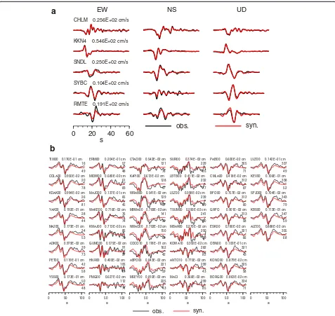
The variance reductions of near-field waveforms, teleseis-mic waveforms, and geodetic data are 86.3, 62.7, and 99.6 %, respectively. The synthetics from the obtained source model match the observations very well (Figs. 4 and 5).z
Fault parameters of the characterized source model Murotani et al. (2008) proposed empirical relation-ships for the characterized source models of large
interplate earthquakes in Japan, and Murotani et al. (2013) demonstrated that the empirical relationships of Murotani et al. (2008) are applicable even to giant (M≈ 9) interplate earthquakes. Here, we characterized the het-erogeneous final-slip distribution of our source model following the procedure of Somerville et al. (1999) (Table 1) and compared the fault parameter ships of the 2015 Gorkha earthquake with the relation-ships of other interplate events and the empirical relationships for interplate earthquakes (Murotani et al. 2008) (Fig. 6). Figure 6 shows that the fault parameters
EW NS UD
of the 2015 Gorkha earthquake are consistent with the previous empirical relationships for interplate earth-quakes. This means that the 2015 Gorkha earthquake was a standard interplate earthquake as far as the fault parameter scaling is considered. The asperity region was located north of Kathmandu (Fig. 5), which corresponds to the centroid location of the GCMT.
Relationship with interplate-coupling distribution, seismic activity, and past large events
In the Himalayan continental collision region, a belt of microseismicity has been observed (e.g., Pandey et al. 1995, 1999), which corresponds to the creeping-locked transition (e.g., Ader et al. 2012). From the microseis-micity belt to the surface, the Main Himalayan thrust fault is considered to be fully coupled and it has been predicted that large interplate earthquakes will occur (e.g., Bilham et al 1997; Ader et al. 2012). In Fig. 7, the source model of the 2015 Gorkha earthquake is com-pared with the interseismic coupling distribution (Ader et al. 2012), the microseismicity distribution before the mainshock (Ader et al. 2012), and the aftershock distri-bution determined by the NSC. This figure shows that the north part of the rupture area of the 2015 Gorkha earthquake overlapped the microseismicity and the after-shocks. Figure 7 also shows that most of the rupture was located in the high-coupling-ratio region (> 0.8).
Nepal has been struck by many large earthquakes, such as the 1505 West Nepal earthquake (Mw≈8.2), the 1833 Mid-Nepal earthquake (Mw≈7.6), and the 1934 Nepal-Bihar earthquake (Mw≈8.1). Considering the in-ferred source regions of these events (e.g., Bilham 1995;
Ambraseys and Douglas 2004; Sapkota et al. 2013), the rupture area of the 2015 event seems to overlap the source region of the 1833 event (Fig. 7). Given that the convergence rate in central and eastern Nepal is 17.8 mm/year (Ader et al. 2012) and that this region has been coupled for 182 years at a coupling ratio of 0.8, the accumulated slip deficit at the time of the 2015 event was expected to be approximately 2.6 m. This value is comparable to the estimated average slip of 2.5 m for the 2015 Gorkha earthquake (Table 1), which suggests the possibility that the 2015 event was the reactivation of the preexisting asperity of the 1833 event.
Waveform simulation in the Kathmandu basin
In the Kathmandu basin, strong ground motions with
predominant components in a 4–5s period were
ob-served during the 2015 Gorkha earthquake (Galetzka et al. 2015; Dhakal et al. 2016). Here, we simulated the long-period ground motions using the estimated source model and 1-D velocity structure models. For the ob-served waveforms in the Kathmandu basin, we used the strong ground motions at Kantipath (KATNP, Fig. 1) recorded by a seismograph maintained by the U.S. Geological Survey (USGS). The calculation method of the synthetics was the same as that of the Green’s func-tions of near-field waveforms. For the 1-D velocity struc-ture model, we used three models (Fig. 8a). M-model is the rock model based on Monsalve et al. (2006) and the same as that used in the calculation of the Green’s func-tions of near-field waveforms. The other models include the structure of the Kathmandu basin. P-model is based on Pandey (2000), who proposed the basin structure
84˚ 85˚ 86˚
27˚ 28˚
0 100
km
100 cm
obs.
syn.
84˚ 85˚ 86˚
27˚ 28˚
0 100
km
100 cm
obs. syn.
(a)
(b)
Fig. 5Comparison of the observed (black) and synthetic (red) static displacements in (a) horizontal and (b) vertical components.Broken contours indicate the final-slip distribution with a 1.46-m interval.Black starindicates the rupture starting point
Table 1Fault parameters of the characterized source model of the 2015 Gorkha earthquake
Seismic moment (N*m) Rupture area (km2) Average slip (m) Asperity area (km2) Average slip of asperity (m)
7 8
Mw
103
104
105
Rupture Area (km
2)
1019 1020 1021 1022
M0 (Nm)
This study Murotani et al. (2008) Murotani et al. (2008)
7 8
Mw
0.1 1 10
Average Slip (m)
1019 1020 1021 1022
M0 (Nm)
This study Murotani et al. (2008) Murotani et al. (2008)
7 8
Mw
102
103
104
Combined Area of Asperities (km
2)
1019 1020 1021 1022
M0 (Nm)
This study Murotani et al. (2008) Murotani et al. (2008)
102
103
104
Rupture Area of Asperities (km
2)
103 104 105
Rupture Area (km2)
This study Murotani et al. (2008) Murotani et al. (2008)
b
a
d
c
Fig. 6Relationship of the (a) rupture area, (b) average slip, and (c) combined area of asperities with seismic moment.dRelationship between the combined area of asperities and rupture area.Open circlesrepresent the interplate earthquakes listed in Murotani et al. (2008).Red closed circles represent the 2015 Gorkha earthquake.Gray linesrepresent the empirical scaling relationships of the interplate earthquakes proposed by Murotani et al. (2008)
1934 (M
w~8.1)
1833 (M
w~7.6)
1505 (M
w~8.2)
0 100
km
84˚ 85˚ 86˚
27˚ 28˚
Coupling
1 0
model on the basis of the results of the common-depth-point reflection survey. D-model is based on Dhakal et al. (2016), who inferred the basin structure model from the horizontal-to-vertical spectral ratios of after-shock records at KATNP following the borehole logging and geological data. The velocity values in the basin part of the D-model are lower than those of the P-model.
Figure 8b shows the comparison of the observed vel-ocity waveforms at KATNP with the synthetic waveforms produced by the structure models. These waveforms were band-pass filtered from 4 to 50 s. The horizontal compo-nents of the observed waveforms have large amplitudes and long durations as compared to the synthetic wave-forms produced by the rock model (M-model). This
EW
NS
UD
Obs.
113.3 cm/s-113.3 cm/s
Syn. by D-model
Syn. by P-model
Syn. by M-model
20 40 60
s
20 40 60
s
20 40 60
s
KATNP
0.6 0.4 0.2 0.0
Depth from surface (km)
0 1 2 3
Velocity (km/s)
D-model P-model
M-model
a
b
Fig. 8aOne-dimensional shear velocity models from surface to 0.6-km depth. D-model (red), P-model (green), and M-model (blue) were based on Dhakal et al. (2016), Pandey (2000), and Monsalve et al. (2006), respectively.bComparison among the observed waveforms at KATNP (black) and synthetic waveforms produced by D-model (red), P-model (green), and M-model (blue)
a
b
Median
0 50
km
Max.: 7.3 m
84.5˚ 85˚ 85.5˚ 86˚
27.5˚ 28˚ 28.5˚
0 7 m
Lower CI
Max.: 1.2 m
84.5˚ 85˚ 85.5˚ 86˚
27.5˚ 28˚ 28.5˚
0.00 1.25 m
Coefficient of lower variance 27.5˚
28˚ 28.5˚
0 1
Upper CI
Max.: 1.2 m
84.5˚ 85˚ 85.5˚ 86˚
27.5˚ 28˚ 28.5˚
0.00 1.25 m
Coefficient of upper variance 27.5˚
28˚ 28.5˚
0 1
-125 0 125
(cm/s)
EW
-125 0 125
(cm/s)
NS
-125 0 125
(cm/s)
20 30 40 50 60
s
UD
KATNP
difference is presumably caused by the site amplification of the Kathmandu basin. The horizontal components of the synthetic waveforms produced by the P-model have little effect on the basin amplification and are similar to the synthetic waveforms produced by the M-model, but not to the observed waveforms. On the other hand, the horizontal components of the synthetic waveforms pro-duced by the D-model are significantly affected by the basin amplification and are similar to the observed ones. Thus, in the long-period band (> 4 s), the synthetic wave-forms produced by the D-model can reproduce the obser-vation much better than those produced by the P-model. We also found that there is little difference in the vertical component among the synthetic waveforms of the three models and that all synthetic vertical-component wave-forms are similar to the observed ones. This means that there was little amplification due to the Kathmandu basin in the vertical component of the long-period band (> 4 s).
Moreover, we investigated the uncertainty of our source model and its effect on the result of the wave-form simulation, using the posterior probability distribu-tions for slips at each subfault on each time window and the source-model ensembles produced by the fully Bayesian source inversion method (Kubo et al. 2016). Figure 9a shows the final-slip uncertainty of our source model. In the region having median slips of 3 m and more, the credible interval values are at most 1.2 m, and the coefficients of variance are mostly under 0.3. In Fig. 9b, the synthetic waveforms produced by each source-model ensemble are compared with the synthetic waveforms at KATNP produced by the optimal source model (Figs. 2 and 3). Both the waveforms were calcu-lated using the D-model. This figure shows that the vari-ance of the synthetic waveforms is not large among the source-model ensembles. These results indicate that the uncertainty of our source model is not so large and does not largely affect the result of the waveform simulation.
Thus, the waveform simulations demonstrated that the overall feature of the observed long-period ground mo-tions at KATNP can be explained by our source model and the basin structure model of Dhakal et al. (2016). However, some discrepancies between the observed and synthetic waveforms still remain. For example, the polarity of the initial phase of the vertical component differs be-tween the observation and synthetics, and this synthetic phase was mainly generated from the relatively large-slip area west-northwest of Kathmandu. This necessitates fur-ther investigations of the source model, particularly the slips west-northwest of Kathmandu. In addition, the wave-form simulation in this study was conducted at only one station (KATNP). For further understanding of the gener-ation mechanism of strong ground motions in the Kathmandu basin, it is necessary not only to improve the structure model of the Kathmandu basin, including the
development of its 3-D model, but also to further develop the strong-motion seismograph network.
Conclusions
We estimated the source model of the 2015 Gorkha earthquake using the joint source inversion with near-field waveforms, teleseismic body waves, and geodetic data. The estimated seismic moment and maximum slip are 7.5 × 10²⁰Nm (Mw 7.9) and 7.3 m, respectively. The derived source model has the unilateral rupture toward the east and a large-slip area north of Kathmandu with the maximum slip. Then, we investigated the relationships among the fault parameters of the characterized source model of the 2015 Gorkha earthquake and found that the fault parameter relationships of this earthquake are consist-ent with the previous empirical relationships of interplate earthquakes. The comparison of the final-slip distribution of this earthquake with the interplate-coupling distribu-tion, seismic activity, and past large events indicated that the 2015 event could be the reactivation of the preexisting asperity of the 1833 Mid-Nepal earthquake. Using the esti-mated source model together with the 1-D velocity struc-ture model of the Kathmandu basin, we simulated the long-period (> 4 s) ground motions at KATNP located in the Kathmandu basin. The waveform simulation demon-strated that the major features of the observation can be reproduced by our source model and the 1-D basin struc-ture model of Dhakal et al. (2016).
Competing interests
The authors have no competing interests to declare.
Authors’contributions
HK analyzed the data, interpreted the results, carried out the waveform simulations, and drafted the manuscript. YD and WS participated in the study design and the interpretation of the results. TK, SA, and HF participated in the study design. All authors read and approved the final manuscript.
Acknowledgements
We thank Prof. Kazuki Koketsu and the anonymous reviewer for their helpful comments. The Department of Mines and Geology, Tribhuvan University, and California Institute of Technology are acknowledged for providing us with high-rate GPS data. Strong-motion data observed by the USGS were gathered from the Center for Engineering Strong Motion Data. Teleseismic data observed by the GSN were collected from the Data Management Center of Incorporated Research Institutions for Seismology. The CMT solution estimated by the GCMT Project and hypocenter information estimated by the NSC were used. Topographic data were obtained from the Geographic Information Network of Alaska. Generic Mapping Tools (Wessel and Smith 1998) were used to draw the figures.
Received: 30 October 2015 Accepted: 21 January 2016
References
Ader T, Avouac JP, Liu-Zeng J, Lyon-Caen H, Bollinger L, Galetzka J, Genrich J, Thomas M, Chanard K, Sapkota SN, Rajaure S, Shrestha P, Ding L, Flouzat M (2012) Convergence rate across the Nepal Himalaya and interseismic coupling on the Main Himalayan Thrust: implications for seismic hazard. J Geophys Res 117(B4):B04403. doi:10.1029/2011JB009071
Avouac JP, Meng L, Wei S, Wang T, Ampuero JP (2015) Lower edge of locked Main Himalayan Thrust unzipped by the 2015 Gorkha earthquake. Nat Geosci 8:708–711. doi:10.1038/ngeo2518
Bilham R (1995) Location and magnitude of the 1833 Nepal earthquake and its relation to the rupture zones of contiguous great Himalayan earthquakes. Curr Sci 69(2):25 Bilham R, Larson K, Freymueller J (1997) GPS measurements of present-day
convergence across the Nepal Himalaya. Nature 386:61–64. doi:10.1038/386061a0 Bird P (2003) An updated digital model of plate boundaries. Geochem Geophys
Geosyst 4(3):1027. doi:10.1029/2001GC000252
Bouchon M (1981) A simple method to calculate Green’s function for elastic layered media. Bull Seismol Soc Am 71(4):959–971
Dhakal YP, Kubo H, Suzuki W, Kunugi T, Aoi S, Fujiwara H (2016) An analysis of strong ground motion and site amplification at Kantipath, Kathmandu from the 2015 Mw 7.8 Gorkha Earthquake, Nepal and its aftershocks. Earth Planets Space (submitted). Galetzka J, Melgar D, Genrich JF, Geng J, Owen S, Lindsey EO, Xu X, Bock Y, Avouac
JP, Adhikari LB, Upreti BN, Pratt-Sitaula B, Bhattarai TN, Sitaula BP, Moore A, Hudnut KW, Szeliga W, Normandeau J, Fend M, Flouzat M, Bollinger L, Shrestha P, Koirala B, Gautam U, Bhatterai M, Gupta R, Kandel T, Timsina C, Sapkota SN, Rajaure S, Maharjan N (2015) Slip pulse and resonance of Kathmandu basin during the 2015 Mw 7.8 Gorkha earthquake, Nepal imaged with geodesy. Science 349(6252):1091–1095. doi:10.1126/science.aac6383
Grandin R, Vallée M, Satriano C, Lacassin R, Klinger Y, Simoes M, Bollinger L (2015) Rupture process of theMW= 7.9 2015 Gorkha earthquake (Nepal): insights into Himalayan megathrust segmentation. Geophys Res Lett 42(20):8373–8382. doi:10.1002/2015GL066044
Kennett BLN, Kerry NJ (1979) Seismic waves in a stratified half space. Geophys J R Astr Soc 57:557–583
Kikuchi M, Kanamori H (2004) Note on teleseismic body-wave inversion program. http://www.eri.u-tokyo.ac.jp/ETAL/KIKUCHI/. Accessed 28 Jan 2015. Kobayashi T, Morishita Y, Yarai H (2015) Detailed crustal deformation and
fault rupture of the 2015 Gorkha earthquake, Nepal, revealed from ScanSAR-based interferograms of ALOS-2. Earth Planets Space 67:201. doi:10.1186/s40623-015-0359-z
Kubo H, Kakehi Y (2013) Source process of the 2011 Tohoku earthquake estimated from the joint inversion of teleseismic body waves and geodetic data including seafloor observation data: source model with enhanced reliability by using objectively determined inversion settings. Bull Seismol Soc Am 103(2B):1195–1220. doi:10.1785/0120120113
Kubo H, Asano K, Iwata T, Aoi S (2016) Development of fully Bayesian multiple-time-window source inversion. Geophys J Int 204(3):1601–1619 doi:10.1093/gji/ggv540. Monsalve G, Sheehan A, Schulte-Pelkum V, Rajaure S, Pandey MR, Wu F (2006)
Seismicity and one-dimensional velocity structure of the Himalayan collision zone: earthquakes in the crust and upper mantle. J Geophys Res 111(B10), B10301. doi:10.1029/2005JB004062
Murotani S, Miyake H, Koketsu K (2008a) Scaling of characterized slip models for plate-boundary earthquakes. Earth Planets Space 60:987–991
Murotani S, Satake K, Fujii Y (2008b) Scaling relations of seismic moment, rupture area, average slip, and asperity size forM~ 9 subduction-zone earthquakes. Geophys Res Lett 40(19):5070–5074. doi:10.1002/grl.50976
Okada Y (1992) Internal deformation due to shear and tensile faults in a half-space. Bull Seismol Soc Am 82(2):1018–1040
Pandey MR (2000), Ground response of Kathmandu valley on the basis of microtremors, Paper. Proceedings of the 12th World Conference on Earthquake Engineering, Auckland, New Zealand, 30 Jan 4–Feb 2000, Paper No. 2106. Pandey MR, Tankudar RP, Avouac JP, Lavé J, Massot JP (1995) Interseismic strain
accumulation on the Himalayan crustal ramp (Nepal). Geophys Res Lett 22(7): 751–754
Pandey MR, Tankudar RP, Avouac JP, Vergne J, Héritier T (1999) Seismotectonics of the Nepal Himalaya from a local seismic network. J Asian Earth Sci 17:703–712 Sapkota SN, Bollinger L, Klinger Y, Tapponnier P, Gaudemer Y, Tiwari D (2013)
Primary surface ruptures of the great Himalayan earthquakes in 1934 and 1255. Nat Geosci 6:71–76. doi:10.1038/ngeo1720
Somerville PG, Irikura K, Graves R, Sawada S, Wald D, Abrahamson N, Iwasaki Y, Kagawa T, Smith N, Kowada A (1999) Characterizing crustal earthquake slip models for the prediction of strong ground motion. Seismol Res Lett 70(1):59–80 Wald DJ, Heaton TH (1994) Spatial and temporal distribution of slip for the 1992
Landers, California, earthquake. Bull Seismol Soc Am 84(3):668–691 Wald DJ, Graves RW (2001) Resolution analysis of finite fault source inversion
using one- and three-dimensional Green’s functions 2. Combining seismic and geodetic data. J Geophys Res 106(B5):8767–8788. doi:10.1029/2000JB900435
Wessel P, Smith WHF (1998) New, improved version of Generic Mapping Tools released. EOS Trans Am geophys Un 79:579
Yagi Y, Okuwaki R (2015) Integrated seismic source model of the 2015 Gorkha, Nepal, earthquake. Geophys Res Lett 42(15):6229–6235. doi:10.1002/2015GL064995 Yokota Y, Koketsu K, Fujii Y, Satake K, Sakai S, Shinohara M, Kanazawa T (2011)
Joint inversion of strong motion, teleseismic, geodetic, and tsunami datasets for the rupture process of the 2011 Tohoku earthquake. Geophys Res Lett 38(7):L00G21. doi:10.1029/2011GL050098
Yoshida S, Koketsu K (1990) Simultaneous inversion of waveform and geodetic data for the rupture process of the 1984 Naganoken-Seibu, Japan, earthquake. Geophys J Int 103(2):355–362
Submit your manuscript to a
journal and benefi t from:
7Convenient online submission
7Rigorous peer review
7Immediate publication on acceptance
7Open access: articles freely available online
7High visibility within the fi eld
7Retaining the copyright to your article