Typically, the hydraulics of torrential rivers is quite different if compared with those of lowlands. Irregularities of the lengthwise river-bed gradient and a significantly varying grain-size distribution of the bed-load are specific features of such rivers (Novák 1981).
The bed-load is usually blended and it consists of sandy, gravelly, and cobble-formed grain par-ticles. Boulders can also appear in some of the mountainous creeks (Novák 1988).
Sudden changes in the flow rate triggered by flash rainfall of short duration and high inten-sity usually hit solely small drainage areas; this is also a typical feature of such channels behaviour (Křovák & Kovář 2005).
High flow rate results in losses of the bed-load from the channel bottom and from the river banks. Thus,
the sediment deposition during the decrease of the driving force becomes an unavoidable consequence. One of the basic objectives of the respective studies is the determination of the stable bed slope of the channel that would resist the driving force during the design floods. The creation of a sustainable bottom slope depends not only on the sediment grain-size distribution, but also on the saturation with water of the bed-load. The process is quite complex and not yet formulated in a comprehensive manner (Dvořák & Novák 1994; Gordon et al. 1996).
The theoretical scope of the study aims mainly at three methods of the stable bed slope analysis. The methods are based on the shear stress theory, on the critical mean channel velocities distribu-tion, and on the critical bed velocity that is based on the bottom velocities.
On the Determination of the Stable Bed Slope of a Channel
Using Mathematical Model
František KřováK
Department of Land Use and Improvement, Faculty of Forestry and Environment,
Czech University of Life Sciences in Prague, Prague, Czech Republic
Abstract: The paper deals with an analysis of selected equations used for the determination of a stable longwise slope calculation of torrential rivers. Irregularity of the gradient, accompanied by heavy bed-load experiencing abrupt changes of the flow as a result of heavy rainfalls of short duration and high intensity, these are typical features impacting the behaviour and characteristics of torrential rivers. The determination of the stable bottom slope, when the river bed is kept unpaved but still provides resistence against harmfull effects of rapids, becomes an essential objective of the study. Three methods are used to determine the stable slope: the first is based on tangent tension (shear stress theory), the second observes a (critical) non-scouring cross-sectional velocity (critical mean channel velocities), and the third applies the bottom layer velocity, (the critical bed velocities). The mathematical hydraulic model HEC-RAS v. 3.1.3 has been used for the verification of the methods in the Jindřichovický creek case study in the Krušné hory.
The hydraulic model HEC-RAS v. 3.1.3 has been used for the method verification in the Jindřichovický creek in Krušné hory.
MATERIAL AND METHODS
The choice of the methods listed below is not accidental, only those have been applied where adequate data were available. With respect to the restricted extent of the paper, the complete formula-tion of the governing equaformula-tions and their theoretical reasoning were omitted. The reader is therefore referred to the respective references, e.g. Novák (1988) or Lopez (1993). Similarly, the methods of the standard (effective) grain size determination are excluded from further considerations.
(1) Methods based on critical shear stress (after Shields)
is = 0.06 × (ρm – ρ) × de (1)
ρ× R
(2) Methods based on critical average channel velocities (Manning-Strickler)
is = vv2 (2)
ks2× R4/3
(3) Methods based on critical bed velocities (No- vák 1988)
is = 0.0035 × C2× de (3)
R
The following equation has been used for the conversion of k and n coefficients,
n = R1/6 (4) 18 × log10 × (12.2 × R )
k
where:
is – stable bed slope (m/m)
ρm – bed-load material density (kg/m3)
ρ – water density (kg/m3)
de – effective grain diameter (m)
R – hydraulic radius (m)
vv – critical mean channel velocities (m/s)
k – coefficient, bottom roughness (m)
n – Manning’s roughness coefficient
ks – mean velocity coefficient of wetted perimeter, unpaved channel bed (after Strickler)
a – the constant in Stickler’s equation related to the value of de (Dvořák & Novák 1994)
C – characteristic of the sediment load (after Novák 1988)
The hydraulic model HEC-RAS has been used to quantitatively analyse the above equations.
Structure of the model
The mathematical hydraulic model HEC-RAS (Hydrologic Engineering Center’s River Analysis System) came into consideration as an optimal tool for the solution of the sediment transport within the river studied. The program HEC-RAS uses an integrated environment of MS Windows and provides an outstanding graphical user’s interface (GUI) in the detailed hydraulic analysis of the open channel flow and of the flow control measures in both artificial and natural channels. It works both in steady and unsteady conditions. The calcula-tion requires the setting up of three principal data categories: the river-bed and control-structures geometry, the hydraulic losses, and the boundary conditions. It is with advantage to use the links to CAD and GIS systems also in 3D display already built into the modelling system. The channel ca-pacity can be investigated by two principle means of solutions for hydraulic open channels analyses, flow control structures included:
(1) To solve the passage of the design flood wave by hydraulic model based on numerical solution of unsteady flow process. Such technique requires hydrographs input at upper boundary profile of the reach and, similarly to the further, the detailed description of geometric and hydraulic river-bed parameters. This is rather demanding compu-tationally and usually out of interest for lesser streams analyses.
(2) To use the methods of steady flow hydraulics in the determination of longitudinal water surface profiles, corresponding to N-year design floods. Indeed, such a method does not provide for solution of an unsteady mode; utilities for a more detailed formulation of flow through control structures are sometimes preferred as an advantage.
– Detailed analysis of the flow through control structures including various hydraulic regimens is also possible, making the model a suitable tool for solving various hydraulic options. It guaran-tees reliable analyses, mainly in locations where the flow control structures affect hydraulics of the open channel flow. This is also the case of the Jindřichovický creek.
– The steady flow model provides higher values in the solution of the water surface profiles; thus its results are on the side of safety.
Therefore, as already stated, the modelling sys-tem HEC-RAS has been used in this study. The detailed program description, the user’s manual and hydraulic formulations are available from (HEC-RAS 2005).
Description of the basin
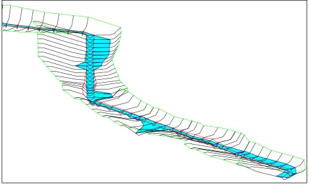
The Jindřichovický creek is a sinistral tributary of the Rotava River at its fluvial kilometer 2.0. Its torrential character is remarkable. The mean slope of the channel is 4%. The catchment area is F < 35 km2, the other factors are: mean altitude H > 200 m MSL, the stream slope is rather vari-able, the flow rates also vary significantly induc-ing enormous erosion, transport- and bed-load sedimentation, stony up to boulder river bed, fluvial lee wards and hide-outs, trout fish zone (Křovák 2002).
Hydrologic ID number: 1-13-01-114 Total catchment area: 5.964 km2 Catchment area to US section of river training:
1.33 km2
Forest coverage: 47%
Length of watershed: 1.62 km Length of watershed divide: 4.35 km Watershed shape factor: A = 0.653 Type of the watershed: Fan-shaped,
hydrographic network not developed Torrential coefficient: KB = 0.118
Table 1 lists the N-year discharges.
The state of the creek prior to the river training
The upper part of the trained river reaches lines up to the channel lining by a stony pavement at lower parts of the creek. Several steps of almost 2 m height are located in the investigated river reach. The river bed is simply trapezoidal, the width of the bed is 1–1.5 m, and the depth 0.6–1 m. The bed suffers from devastation by extensive stream-side and bottom scouring in several reaches. Several bottom breakdowns and outcrops appear in the channel created by scouring more than 3 m in depth. In these locations, the bed is laid bare down to the bedrock. The river-bed is stony, granular-ity of carpeting 5–10 cm, and granulargranular-ity of the boulder strata 20–25 cm. These characteristics were identified by a detailed field investigation of all river reaches. Sizable sandy benches appear in patches of lower flow velocity. The flood plain is overgrown by a mixed forest, the spruce cover dominates. Herbal vegetation with marshland- and ruderal species dominating makes up the sub-canopy of the plain (Křovák 2002).
Hydraulic structures and proposal of water management measures
[image:3.595.63.534.717.757.2]Being led along the main stream of the basin, most of the proposed thalweg will copy the exist-ing centerline. Due to the considerable lengthwise slope, the channel has only a little tendency to meander. Therefore, only few corrections will be necessary to apply in some river reaches where the irregular trace of the bed will be replaced by free-curvature bedding. The present hollow-ranges of breakdowns will be utilized for the creation of pools. The stabilizing of the pools will be effected using transversal structures of stony riprap and stone packing (rockfill). The modified bed will keep the trapezoidal shape, width in bed 1 m, cross sectional slope 1:1.5 up to the bank lines, stretches with pools excluded. The river bed at
Table 1. Design discharges
N (years) 1 2 5 10 20 50 100
the foot and banks up to the height of 0.25–0.30 m will be protected by stone packing (stony rock-fill). Rest of the banks above the stony pavement will be sown.
In effect to considerable gradient in design, the vertical alignment will take into account a number of structures for the slope control of the channel-bed. These will be constructed as wooden sills (shoals), stony weirs (steps) and rock chutes (overruns). Constructional modifications of the structures will provide for fish migration in both directions. This means that the constructional height should not exceed 0.4 m at any cross sec-tion and the cross secsec-tion of the overrun plane should provide for continuous water jet. Natural materials will be exclusively used for all hydraulic measures and their form will cope with the natural formation of the torrent.
Computation scenarios
The evaluation of the channel capacity, the flow velocity, and the proposed stable slope of the riv-er-bed covers 3 choices of the river reaches, all characterized by the effective grain size of de = 0.06 m (d6), 0.10 m (d10), and 0.16 m (d16).
Hydrologic input data
The above-mentioned data set-ups were com-puted for 2 flow rates of Q100 = 6.9 m3/s and Q5 = 2.2 m3/s.
Geometric input data of the river bed and of the flow control structures
All river reaches including hydraulic structures on the trained stream were calculated as the re-sults of the detailed survey of longitudinal- and transverse profiles. The river profiles are notably impacted by these measures.
Hydraulic input data of the river
[image:4.595.71.522.470.737.2]The principle hydraulic characteristics of the model are as follows: the roughness coefficient n devised by Manning, and coefficient k according to Strickler. With respect to the original soil of the river bed, to gravel materials, and to building ma-terial of the structures, the values of the hydraulic parameters were selected according to HEC-RAS user’s manual, determined by the methods of soil mechanics or from the field survey individually for
each cross sectional profile. Granulometric analy-sis was applied to determine the effective grain size de. The C coefficient after Novak came in for the torrential rivers Rotava and Rolava (Novák 1988). The sediment mixture matches the blended
[image:5.595.90.525.88.338.2]torrential bed-load of granite geological forma-tions. Sediment particles are rounded, the shapes of sphere and ellipsoid dominate.
Table 2 shows well-arranged hydraulic charac-teristics of the considered river.
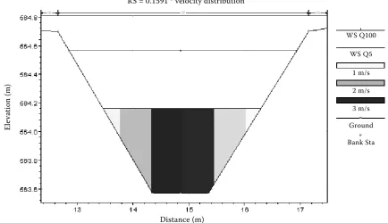
Figure 2. Velocity distribution in cross section, flooded by Q5 and Q100
RS = 0.1591 * velocity distribution
Distance (m)
El
ev
at
io
n
(m
)
Figure 3. Shear stress distribution in lengthwise profile, flooded by Q5 and Q100
Distance (m)
Sh
ea
r L
O
B,
S
he
ar
C
ha
n,
S
he
ar
R
O
B
(N
/m
2 )
WS Q100
WS Q5
1 m/s
2 m/s
3 m/s
Ground
Bank Sta
[image:5.595.87.505.471.735.2]RESULTS OF CALCULATIONS
Steady-state calculations under non-uniform flow conditions were performed for three selected river-reaches, all characterized by the effective grain size de. The discharge, mean flow veloc-ity, and geometric characteristics of the cross sectional profiles were identified by virtue of the model HEC-RAS. (Figures 1–3) To specify realistic values of the roughness coefficients, the pictorial description from www.hec.usace.army.mil/n-val-ues.index was used.
On the basis of these data the individual equa-tions have been verified and the results summarized into the following pictures and graphs (Figures
4 and 5).
CONCLUSIONS
The basis for the calculation of the stable bottom slope became the classical Shields equation (1) based on the shear stress philosophy. Surprisingly, a good agreement was also shown with the calcu-lation after Manning-Strickler (2). The Eq. (3) of
Novak indicates somewhat higher values of the slope stability. On the other hand, it reflects the features and the origin of the bed-load motion. The difference between the extreme results amounts to 10% (Figures 4 and 5). Such an agreement is influenced both by the selection of the equation and, primarily, by detailed analysis of the sediment load granularity and by a careful evaluation of the roughness coefficients. Such procedure is usu-ally laborious and thus ineffective in engineering practices. Consequently, for the torrent training it is hardly applicable.
[image:6.595.62.364.576.758.2]Due to the complexity of the processes involved in the water-induced sediment load, the problems of water saturation by the bed-load were totally omitted in this analysis. Until today, the process has not yet been completely examined and thus its use in field is not easily applicable. At a high rate of saturation, part of energy entering the bed-load transport and the scouring may be miss-ing. Unexpectedly, this may become a paradox if applied at higher flow rates. In addition, the design flow rate determination brings further difficulties. The uncertainty in its definition is
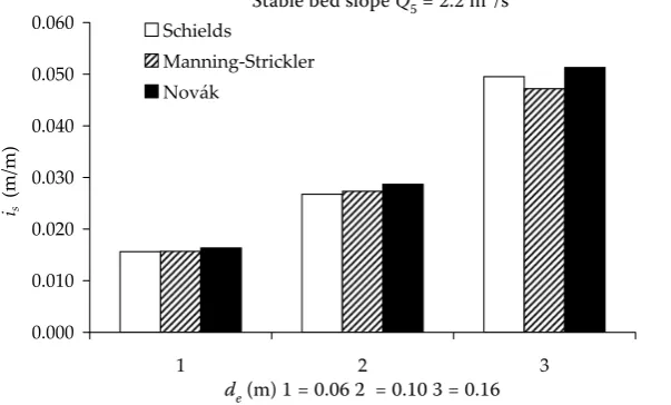
Figure 4. Comparison of stable bed slope; equations of Schields, Manning-Strickler and Novak, discharge Q5
d (m) 1 = 0.06 2 = 0.10 3 = 0.16
Table 2. Hydraulic characteristics
Reach No. de a n k ρm ρ C R
1 0.06 18.29 tables tables 2650 1000 5.58 calculated
2 0.10 16.78 tables tables 2650 1000 5.58 calculated
3 0.16 15.31 tables tables 2650 1000 5.58 calculated
0.000 0.010 0.020 0.030 0.040 0.050 0.060
1 2 3
is
ȱ(m/m)
Schields
Manning-Strickler Novák
rather complex, particularly in the selection of its “true” value needed for the determination of the optimum stable slope. For the Jindřichovický creek, the centenary flood from 1 km2 amounts to, e.g., 5.2 m3/s.
In general, it can be stated that the model accu-racy increases with the reliability of granulometric analysis of the bed-load. The more detailed and reliable data exist, the better results of the model can be expected. The optimal determination is questionable from the practical point of view and also from the economic aspects. Therefore, it is with advantage to practice the use of the model categories, where cross section profiles can be easily subdivided in horizontal and in vertical directions. Then spatial distribution of the values of n or of k in any river section can be investigated. Since no comprehensive method still exists for the channel roughness determination, torrent-training designer is forced to use its own experience. The freely distributed documentation on HEC-RAS Web pages has been made available and it becomes a useful starting point for initial estimates of both parameters. In these materials, one can find well verified roughness values for natural rivers, with respect to detailed geom-etry of the river-bed and to drainage area. The photo-documentation of the representative cases in the United States is also available. It would be therefore highly recommended to work out similar guidelines, at least for the representative Bohemian torrential rivers. Professor Novak has initiated such an effort in the past and it remains just to follow up.
Comment at the end
The last version HEC-RAS 4.0 Beta (2006) in-cludes two new features related to the sediment transport.
Sediment transport/movable bed analyses.
This component of the modelling system is in-tended for the simulation of one-dimensional sediment transport/movable boundary calcula-tions resulting from scour and deposition over moderate time periods (typically years, although applications to single flood events are possible). The sediment transport potential is computed by grain size fraction, thereby allowing the simulation of hydraulic sorting and armouring. The model is designed to simulate long-term trends of scour and deposition in a stream channel that might result from modifying the frequency and duration of the water discharge and stage, or modifying the channel geometry. This system can be used to evaluate the deposition in reservoirs, design channel contractions required to maintain naviga-tion depths, to predict the influence of dredging on the rate of deposition, to estimate maximum possible scour during large flood events, and to evaluate sedimentation in fixed channels.
Sediment Impact Analysis Methods (SIAM).
SIAM is a sediment budget tool that compares annualized sediment reach transport capacities to supplies and indicates the reaches of overall sediment surplus or deficit. SIAM is a screening level tool to compute rough, relative responses to a range of alternatives, in order to identify the most promising alternatives (which should then
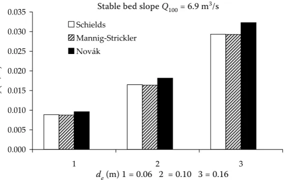
Figure 5. Comparison of stable bed slope; equations of Schields, Manning-Strickler and Novak, discharge Q100
de (m) 1 = 0.06 2 = 0.10 3 = 0.16 0.000
0.005 0.010 0.015 0.020 0.025 0.030 0.035
1 2 3
de (m) 1=0.06 2=0.10 3=0.16
is
(m/m)
Schields Mannig-Strickler Novák
[image:7.595.70.358.86.266.2]Corresponding author:
Ing. František Křovák, CSc., Česká zemědělská univerzita v Praze, Fakulta lesnická a environmentální, katedra biotechnických úprav krajiny, Kamýcká 129, 165 21 Praha 6-Suchdol, Česká republika
tel.: + 420 224 382 138, + 420 224 382 148, e-mail: [email protected] be modelled in more detail). The algorithms in
SIAM evaluate the sediment impact caused by local changes in the system from the sediment continuity perspective. The results map potential imbalances and instabilities in a channel network and provide the first step in designing or refin-ing remediation. Users can begin with the exist-ing geometry and flow data and develop a set of sediment reaches with unique sediment and hydraulic characteristics. The SIAM program will then perform sediment transport capacity computations to determine potential imbalances and instabilities in a channel network. SIAM does not predict intermediate or final morphological patterns and does not update cross sections, but rather indicates trends of locations in the system for potential sediment surpluses or deficits. The results can be used to design or refine remediation efforts in the system.
References
Dvořák J., Novák L. (1994): Soil Conservation and Silviculture. Development in Soil Science 23. Elsevier, Brázda, Prague
Gordon N.D., McMahon T.A., Finlayson B.L. (1996): Stream Hydrology – An Introduction for Ecologist. J. Wiley, Sussex.
HEC-RAS (Hydrologic Engineering Center’s River Ana-lysis System), Version 3.1.3, (May 2005): Computer Program. US Army Corps of Engineers, USA. HEC-RAS Version 4.0.0 Beta (Nov 2006): Computer
Program. US Army Corps of Engineers, USA.
Lopez L. (1993): Torrent control and streambed stabi-lization. FAO, Rome.
Křovák F. (2002): Adaptation of Jindřichovický creek. Design, LČR OST, Plzeň. (in Czech)
Křovák F., Kovář P. (2005): Discharge modelling on forest torrent sections. Zprávy lesnického výzkumu. Krajina, les a lesní hospodářství. Svazek 49, č. 1–4/2004. VÚLHM Jíloviště-Strnady, 51–54. (in Czech)
Novák L. (1981): Protection and Creation of Landscape II. VŠZ, Praha. (in Czech)
Novák L. (1988): Torrent Bed Stabilization. VŠZ, Praha. (in Czech)
www.hec.usace.army.mil