UAVs - Unmanned Aerial Vehicles in Landscape Practice
Technical Information Note 3/17 (23rd November 2017)
______________________________________________________
CONTENTS
1. About this note ... 3
2. Drone Terms & Operations ... 5
3. Purpose, Use & User ... 7
4. Drone Operations... 7
5. Flight Planning, Operation & Post-Processing ... 9
1.
About this information note
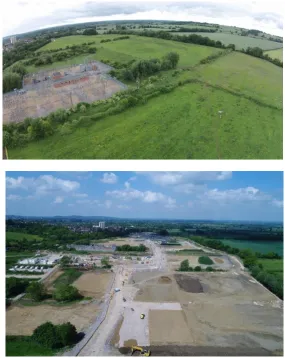
Figure 1: Photo: Cureton, P. Phase 1 Construction Progress, October 2017, North-West Cambridge De-velopment. Planning Permission 2012, Masterplan by AECOM, development by University of Cam-bridge.
1.1 This information note particularly covers drone operations and uses for deployment in UK air-space. Although some detail is included for cautionary purposes, this note is not to be taken as guidance and effort has only been made to ensure its accuracy at the time of publication.
1.2 Drones or Unmanned Aerial Vehicles (UAVs) can be deployed and controlled by a variety of systems with direct application to landscape practice. Drones provide new survey possibilities and operate in a sort of ‘hover space’ between human scales of landscape observation and low-flying light aircraft usually between 10m –120m. Drones thus provide ‘near range’ visual information amongst other sensory data sets. In that sense, new perspectives on the spatial layout, landscape conditions, and almost immediate data capture provide a powerful new de-sign tool for sites in a highly cost-efficient manner.1
1.3 Some Landscape practices are commissioning drone operators or creating their own in-house systems.
1.4 A Landscape practitioner looking to offer drone services directly or indirectly should note Standard 6 of the Landscape Institute Code of Conduct (2012) and the need to provide suf-ficient professional and technical competence for the required work.
1.5 Two key sources of drone guidance are the Civil Aviation Authority (CAA) and The Associa-tion of Remotely Piloted Aircraft Systems (ARPAS).
1.6 Further knowledge development can be achieved with relevant NQE (National Qualified En-tity) companies which are approved by the Civil Aviation Authority to provide training for pilots to complete a PfCO: Permission for commercial operations.
1.7 This technical note complements The Survey Association ‘Client guide to small unmanned air-craft surveys’, Issue 4, 2016.2
1.8 It should be noted that as well as data intentionally captured by drones there may be data unintentionally captured which falls within the scope of security or data protection legislation (discussion of which is outside the scope of this note).
1.9 This note has been prepared on behalf of the Landscape Institute by a working group compris-ing the followcompris-ing members:
Dr Paul Cureton, University of Lancaster Dr Olaf Schroth, University of Sheffield Simon Odell, Landscape Institute (Editor)
1.10 Other contributors were:
Dr Sue Wolfe, Business Development Director, ARPAS Matt Harmsworth, Vice Chairman, ARPAS
Ramon Keeley, Ubiety Landscape & Urban Design
Nick Bolton, Director & Principal Arboricultural Consultant,
Lockhart Garratt – Environmental Planning and Forestry Consultants Peter Wilder, Director, Wilder Associates
Dr Peter Thomas, Lecturer in Aerospace Engineering, University of Hertfordshire Leonine Kunzwa, Lecturer in Aerospace Engineering, University of Hertfordshire
1.11 The consultation process on this document included inviting comments from the wider LI membership, but particular scrutiny was encouraged by:
ARPAS – Association of Remotely Piloted Aircraft Systems LI Technical Committee and Digital Practice Working Group
LI Members subscribed to the Visualisation discussion group on Talking Landscape
2.
Drone Terms & Operations
2.1 ‘Drones’ are a universal generic term for fixed wing or multirotor vehicle. Standard terms are:
• Remote Piloted Aircraft Systems (RPAS) (preferred term by Drone Pilots); • Unmanned Aerial Vehicles (UAVs) (preferred term by Drone Pilots); • Small Unmanned Aerial System (SUAS);
• Small Unmanned Aircraft (SUA) (UK Legal Term);
• Unmanned Aircraft Systems (UAS) (Entirety of a System); and • Unmanned Aircraft (UA)
2.2 In essence, the terms refer to aerial vehicles operating with various degrees of autonomy. The operation of these vehicles requires the pilot to understand the flight system which varies in complexity. By and large most civilian and consumer drones refer to remotely controlled ro-tary gyroscopically stabilised quadcopters which have gimbals that provide a stable platform for an HD camera or sensor. The public typically relates to the aerial vehicles as drones, UK legislation refers to SUAs, and training organisations use UAVs & RPAS.
2.3 UAVs in the UK operate below <20kg and more often in the 0-7kg category. They can be in Multi-rotor or fixed-wing types. Drones weighing above 20kg require additional permissions.
2.4 Commercial Drones navigate using GNSS (Global Navigation Satellite Systems) GPS. The re-mote controller or transmitter is called a Ground control station (GCS). GCS can be complex systems, sophisticated pieces of software/hardware that communicate with the UAV via a transmitter. Modern GCSs display real-time data on the UAVs performance and position and can serve as a ‘virtual cockpit’. Multi-rotary vehicles have between 4-8 rotors. Fixed wing drones can carry heavier payloads but are not able to hover in fixed positions. Fixed wing craft require runways or take off strips, and can travel for longer distances, travel at higher speeds and can survey greater distances +/1 1km². There are also hybrid models called tilt wing craft which trade off the two benefits of faster speeds and distances and maintaining fixed stable positions. In addition to this, drone kites and dirigibles can be used to survey landscapes and urban environments.3
[image:5.595.276.511.552.719.2]2.5 Drone usage is governed by three levels of Avi-ation Bodies; InternAvi-ational, European4 (or Equivalent) and National, in this case, the Civil Aviation Authority.
Figure 2: International, European and United Kingdom Airspace Hierarchy.
3 Any tethered drones must follow CAA Guidance and is subject to Air Navigation Orders (ANO) of UAVs See - CAA, Tethered
Unmanned Aircraft, https://www.caa.co.uk/Consumers/Unmanned-aircraft/Our-role/Tethered-unmanned-aircraft/ (Accessed 27/7/17).
4 UK CAA have indicated that membership of the Single European Sky will not be impacted by Brexit. Having complex aviation laws
2.6 Drone operators currently do not operate under EASA regulations. However, the introduction of Standard European Rules of the Air (SERA) will see some regulatory changes. SERA applies to every aircraft operating in EU airspace regardless of type or state of registration. But as the rules will not cover all aspects of the Rules of the Air, Member States may keep supplementary rules that complement SERA.5
2.7 The Air Navigation Order (ANO) is a legal instrument which covers civil aviation in the UK and governs the legal requirements of drone flights.6 Commercial operation of a Small Unmanned Aircraft (SUA) (using the legal term) requires a permission: Any paid work or any work leading to a monetary output such as promotional materials is defined as ‘valuable consideration’. In contrast, recreational flying and research are not a valuable consideration under current reg-ulations.
“...any operation of an aircraft other than for public transport (a) which is available to the public; or (b) which, when not made available to the public, is performed under a contract between an operator and a customer, where the latter has no control over the operator, in return for remuneration or other valuable consideration.” (CAA Guidance note IN–2016/073, 2016).
2.8 “Typically those commissioning drones ensure the contracting party has a Permission for Com-mercial Operations (PfCO) or a PfCO inhouse if conducting work. Pilots in practices or as con-tractors hold Public Liability Insurance which is compliant for drone operations from a NQEs (National Qualified Entity). The pilot maintains an operations manual that details the extent of the permission, and the CAA approves this document. The commissioner will check these documents before any external drone operator commission.”7
2.9 Larger UAVs which carry payloads over 20kg are not currently permitted to fly in any non-segregated airspace in the UK for example, without explicit permission from the CAA. Similar guidance should be consulted in each country where units are being deployed, starting with the International Civil Aviation Organisation drone toolkit (ICAO).
Figure 3: CAA Guidance and methods for UAS operations and supportive legislation.
2.10 ANO Guidance
‘UAS Operations in UK Airspace’ CAP722 is a relevant Guidance Document
https://publicapps.caa.co.uk/modalapplication.aspx?appid=11&mode=detail&id=415
5 CAA, Standardised European Rules of the Air,
https://www.caa.co.uk/Commercial-industry/Airspace/Rules-of-the-air/Standardised-European-Rules-of-the-Air/ (Accessed 26/7/17).
• Civil Aviation Publication (CAP) 722
• Unmanned Aircraft System Operations in UK Airspace - Guidance • Information Commissioner’s Office
• CCTV Code of Practice
2.11 ANO Legislation
The Air Navigation Order 2016 (ANO) is the legislative element of SUA operations http://www.legislation.gov.uk/uksi/2016/765/contents/made)
Article 23 permits exemptions from certain exemptions classes of aircraft. The main articles affecting UAVs are the following:
• Article 94 – Small Unmanned Aircraft
• Article 95 – Small Unmanned Surveillance Aircraft
• Article 241 – Endangering safety of any persons or property
2.12 EASA NPA 2017-05 (A)
In May 2017, the European Aviation Safety Agency (EASA) published the final draft of Notice of Proposed Amendment concerning drones (EASA NPA 2017-05 (A)), which is likely to be-come law by mid-2018. The EASA NPA defines three categories of drone operations 1) Open (low risk), 2) Specific (higher risk) and 3) Certified. According to the new legislation, each pi-lot and drone must be registered with a national body such as the CAA. However, for stand-ard operations using an off the shelf UAV, the open category license might then be easier to obtain than under current legislation.
3.
Purpose, Use and user(s)
[image:8.595.110.524.198.476.2]3.1 A commercial drone pilot is expected to hold – flight planning material, landowner’s permis-sions, pilot logs, site assessments, aircraft records and maintenance logs as well as insurance and submit these for each PfCO renewal.
Figure 4: General Code of Practice for Drone Use8.
3.2 Drones in commercial civilian operations follow the guidance that they must remain in view VLoS (Visual Line of Site), have manual piloting capability at all times in case of GPS signal loss, have a flight log and safety operations manual. Recently ‘Drone Safe’ set up by the Civil Avia-tion Authority in the United Kingdom has produced a general code of practice to support its legislation:
D
on’t fly near airports or airfieldsR
emember to stay below 400ft (120m)O
bserve your drone at all times – stay 150ft (50m) away from people and propertyN
ever fly near aircraftE
njoy responsibly
3.3 Pilots should know their unmanned system, its full functionality and check deployment is legal before the operation. This process is part of pre-flight planning stages. Consulting aeronautical maps and engage in inspection and safety checks of their equipment as well as desk-based site and risk assessment are typical and necessary duties.
3.4 The pilot should record the areas of operation and mitigate risks. They should check the class of airspace they operate in and gather permissions if necessary; they must also document local aerodromes, and air spaces should the vehicle suffer a loss of control. The distance is generally ten nautical miles from the area of operation.
3.5 The drone cannot fly within 30m of any person during take-off and landing. A drone must remain 50m clear of a vessel, vehicle or structure. A drone must not fly within >150m of a congested area and cannot overfly over the area nor fly over crowds of >1000 persons (See Figure 4).
3.6 If the drone operator holds a PFCO, a standard permission they may operate >50m laterally to a congested area. They cannot overfly. Some pilots may have exemptions for closer proximity flying.
3.7 Drones must operate no further than 500m horizontally and 120m vertically of the pilot and remain in the visual line of sight (VLOS). Extending the VLOS requires a safety case to the CAA. Beyond the VLOS (BVLOS) has yet to be approved by the CAA. (See Figures 2 & 5).
3.8 There are two types of Airspace in the UK – Controlled - *A, C, D, E and Uncontrolled - G. Drones can fly in controlled airspace – class A, B, C, D, E if they are between <0-7kg of total weight and payload, through notification to the air traffic control unit is recommended. Some areas of UK airspace contain danger areas, prohibited zones and restricted areas. These areas may have airdromes, glider sites, high-intensity transmitters or military activity. Drones may also have in built software ‘geo-fences’ preventing the device from entering these airspaces.
3.9 Drones can operate within these restrictions and proximities to people only if individuals are under the control of the pilot.
3.10 Drone flights require landowner permission where the drone takes off and lands. Councils, Parishes and park spaces may have bylaws for drone usage and operators are expected to check these in pre-flight phases. National Trust and Crown Estates also have strict guidelines (mainly referring to the requirement of a fee for commercial aerial work). Other landowners such as Network Rail are also developing guidelines.
3.11 Drones can only be operated in daylight hours 30 minutes before sunrise and 30 minutes after sunset unless special permissions are granted which are called exemptions (See Figure 2 & 5).
3.13 Drones GPS position and operation adheres to no-flight zones commonly termed safe areas or geo-fences and follows manufacturer installed maximum altitude guides. Drones may en-counter geofences – geographical areas fencing and prohibiting drone flight in restricted air-space.
3.14 Most commercial and civilian drones use LiPO batteries9 (Lithium-ion Polymer) which limit flight time- currently a maximum of fifty minutes. Heavier payloads, flight conditions and qual-ity of the unit can further reduce this flight capabilqual-ity.
4.
Drone Operations
Figure 5– Drone Usage Table for Landscape Practice. The table shows the common practical deploy-ments, limitations and extended permissions and exemptions required to fly in certain environments.10
4.1 Drones may be used at remote sites, to survey sites, to monitor construction phases, be de-ployed for inspection and maintenance and used for vegetation monitoring.11 They may also have a value for rapid survey of phenomena such as flooding. The various uses of drone are a testimony to its growth. Commonly drones are used to map areas to create a series of still orthographic images which are then stitched post-flight processing, detecting identical points to create a 3D point cloud from which ortho-mosaics are derived.12 These assets are used to create 3D Models and Meshes and are exported in some standard file formats (see Part 5).
10 Cureton, P, November 2017, (for this publication)
11 Wilder, P. (2016). Welcome to the drones club. Landscape Institute, 35–38.Also: Salamí, E., Barrado, C., & Pastor, E. (2014). UAV flight
experiments on the remote sensing of vegetation areas, 1–25. http://doi.org/10.3390/rs61111051
12 Ortho-Photo: an orth-photo has been geometrically rectified (or flattened) describes true distances and is an accurate representation of the
This data can be used in BIM workflows and be used as bases for cut and fill calculations and grading amongst many other computational processes.
Figure 6: Landscape Architecture UAV detailed applications.13
4.2 The engagement of drone pilots requires inspection of proper insurance and permission for commercial operations. The Drone Safe Register is a growing body of CAA approved pilots, though an inspection of PfCO and Insurance can also be an alternative.14 The Association of Remotely Piloted Aircraft Systems (ARPAS) also has a list of its members which are CAA ap-proved.
4.3 Procuring drone services requires planning of required outcomes. Professionally trained sur-veyors with UAV services are likely to be the preferable option if advanced maps and photo-grammetry or LiDAR capture are required. The best practice option for complex and major works requires pilots and organisations with higher levels of operative competency. Surveyors
13 For Tree Surveys see: (Liang, H., Li, W., Zhang, Q., Zhu, W., Chen, D., Liu, J., & Shu, T. (2017). Using unmanned aerial vehicle data to
assess the three-dimension green quantity of urban green space: A case study in Shanghai, China. Landscape and Urban Planning, 164(159), 81–90. http://doi.org/10.1016/j.landurbplan.2017.04.006)
[image:12.595.78.522.117.515.2]may also have special permissions for close and restricted surveys, have higher liability insur-ance values and more importantly trained in mitigation and risk reduction.
Figure 7: Drone Operator: Sky Cam East (James Hazell), Visualisation: Ubiety Landscape + Urban Design (Ramon Keeley). In this case, elected councillors who are responsible for determining detailed planning applications and the wider public as consultees often find it very difficult to visualise a proposed devel-opment from 2D plans and drawings. 3D artists impressions have typically helped overcome this, and in more recent years this has been augmented by the use of very detailed computer generated renderings. The more recent use of Unmanned Aerial Vehicles (UAVs) brings a further dimension to this in providing the affordable opportunity to visualise a proposed development within its surrounding environment when viewed from some alternative perspectives other than just ground level or existing adjacent struc-tures.
4.4 Landscape Practices may also wish to share basic Drone Information to clients to ensure they understand processes and applications which can be found here - http://dronesafe.uk/
4.5 For a landscape practice seeking a staff member to become trained, the CAA Approved NQEs will be relevant.15
4.6 A standard CAA permission requires a pilot to provide Proof of Competence and maintain rec-ords. This could be in the form of a logbook and the Operations Manual which contains; flight plans, landowners’ permissions, pilot logs, site assessment, aircraft records and maintenance records. These documents must be available for inspection if the CAA request.
15 CAA Guidance Drones for Commercial Work
4.7 A drone operator or pilot operating within a landscape architecture practice must hold public, and aviation liability and the insurance must be EC785/2004 compliant. The insurance pre-mium will be calculated on pilot experience, flight hours and the typical environments that the drone is deployed.
4.8 A landscape practice may wish to have a pilot operator as a sub-contracted element of their work portfolio. This allows the pilot to receive commissioned work when both firms tendered on the same project. In this case, the arrangement would allow practices to maintain confi-dentiality and avoid conflict of interest. This structure also follows best practice to Standard 10 of the Landscape Institute Code of Conduct (2012).
[image:14.595.105.391.331.690.2]4.9 To operate in the Visual Line of Sight (VLOS), the pilot must maintain direct unaided visual contact to monitor flight paths and avoid collisions. Operating a drone outside of the VLOS risks collision as the pilot only has the mounted camera frontal view, and obstacle avoidance sensors will not necessarily detect cables or small objects. Beyond the Visual Line of Sight (BVLOS), applications require additional permissions and as yet to be awarded in the UK. BVLOS will likely change in 2018 and new articles and permissions will come into force.
Figure 9: Special Permissions and Exemptions from the CAA can be given to pilots and organisations able to mitigate risks and hold sufficient proficiency and technical training. These activities are generally features of professional surveyors with UAV capability.
4.11 Pilots may submit an Operational Safety Case (OSC) for complex site surveys. If a pilot has a tethered drone, for example, it may help the pilot gain an OSC as this mitigates some factors when operating in restricted spaces.16 OSCs can be time consuming, and the cost effectiveness to a practice and reoccurrence must be carefully assessed.
4.12 A drone pilot may require a spotter and be required to access construction sites. A spotter can be used for EVLOS, though will need additional training and specific consent from the CAA.
Site access should be accommodated in all pre-flight plans, pre-construction meetings and compliance with CDM regulations 2015. The drone pilots site assessment and risk assessment form (risk register) should be shared with the nominated Principal Designer, and or Principal Contractor. A drone pilot as part of a landscape practice may also need to be accounted for on lone-worker procedures and policies of practice.
4.13 Any accidents, crashes or injuries that occur must have Mandatory Occurrence Reports (MOR). This is a system not to attribute liability, but for the reinforcement of safety of drone opera-tions. An example of an MOR could be a bird strike, loss of control or structural damage. There is a duty to report these issues.17
16 CAA Small Unmanned Aircraft Operations Within London and Other Towns and Cities
http://pulicapps.caa.co.uk/modalapplication.aspx?appid=11&mode=detail&id=6511 http://publicapps.caa.co.uk/modalapplica-tion.aspx?appid=11&mode=detail&id=6497 (Accessed 27/7/17).
CAA Small Unmanned Aircraft: Congested Areas Operating Safety Case (CAOSC)
http://publicapps.caa.co.uk/modalapplication.aspx?appid=11&mode=detail&id=6497 (Accessed 27/7/17).
17 See CAA Mandatory Occurrence Reporting
5.
Flight Planning, Operation & Post-Processing
[image:16.595.108.500.185.550.2]5.1 It is important in pre-flight planning and procurement of drone services to envisage the ex-pected outcome. For example, are 2D maps required? Are multiple flights across various sea-sons needed or is the site inaccessible apart from drone flight and BVLOS?
Figure 10: Automated Flight Options for different requirements for UAVs.
5.2 There are some automated flight patterns and post-processing applications available for drone use. Provided that the VLOS rules are obliged.
• A 2D map will follow waymarks in a grid pattern.
• A 3D map will require multiple grid patterns overlaid.
• An object of specific interest will involve a drone manoeuvring around a chosen object at various altitudes.
5.3 Surveying and mapping involve waymarking in pre-flight and some software applications such as DJI GS Pro, Pix4D Capture, PhotoScan, Drone Deploy and Litchi.
5.4 Orthophotos are a hybrid between maps and aerial photographs. They have been corrected for geometrical distortion and have been registered and matched to a coordinate system. The images are combined, and colour differences emerged. This is a cost-effective mode of gath-ering spatial data.
5.5 A Ground Control Point (GCP) is a point when coordinates are known and is used a basis to reference images captured to ensure accuracy.
5.6 The orthophotos are commonly loaded into photogrammetry software and processed through an algorithm to make 3D models (GeoTIFF, KML, STL, OBJ, DXF, FBX, SKP). Identical points between each image are found, and these are called key points. The more overlaps in the photographs, the more 3D key points that can be established. The flight pattern, some ground control points and range of angles, oblique, plan will also influence the quality of the output.
5.7 Using a ground sampling distance calculator will determine the altitude of the drone for survey and the required resolution. When mapping vegetation, an image resolution higher than 10cm/pixel follows best practice. Water, snow and sand provide little visual information for algorithms to reconstruct 3D models and reflective surfaces should also be accounted.
5.8 Drone operations can be immersive using first-person video goggles (FPV). The drone pilot may have two FPV headsets allowing clients to experience the survey and also direct photog-raphy as appropriate. Flying FPV is not suitable for commercial operation and applies in recre-ational flights.
Figure 11: Wilder Associates first began to explore the use of AV technology and its applications for land planning in January 2015 to augment its capabilities in terrain modelling and hydrology analysis for the design of SuDS systems. Since many of our projects involve large tracts of land, it is often difficult or expensive for clients to provide information quickly that can be used in the initial site appraisal and planning process. The use of UAVs as a mapping platform is still relatively new, and our research involved the selection of the best aircraft, operating systems, flight planning systems and post-processing software for our application.
We started with a budget of £20,000 for the investment in the aircraft systems, accessories, computer hardware, software, training, permits, insurance and the development of a new website for the Survey Drone Ltd which we established as a separate trading entity. We started with one UAV, the DJI Inspire 1, as it has us an all in one flying platform with the capability to switch cameras for different applications from aerial filming through to survey. Since its inception Survey Drone has grown into a successful company in its own right, carrying out large-scale site surveys in countries such as Africa, Spain, Romania and the UK. We also provide aerial photography services for developers wishing to sell potential or future views from developments, and we are also using the GPS technology for mapping potential views in our LVIA work.
6.
Appendix
–
UAV Terms
ATZ - Aerodrome Traffic Zone
BVLOS - Beyond visual line of sight
CAA - Civil Aviation Authority
CRP Close-Range Photogrammetry
EASA - European Aviation Safety Agency
EVLOS - Extended visual line of sight
GCP - Ground Control Point
GLONASS/GNSS - Global Navigation Satellite System
GPS - Global Positioning System
ICAO - International Civil Aviation Organisation
LiPo - Lithium polymer
NQE - National Qualified Entity
OSC - Operational safety case
PfCO - Permission for Commercial Operation
RPAS - Remotely piloted aircraft system
SERA - Standard European Rules of the Air
SUA - Small unmanned aircraft
© Nov 2017 Landscape Institute Charles Darwin House 2 107 Grays Inn Road London WC1X 8TZ www.landscapeinstitute.org
Document history