0
Bachelor Report
Cycling in Vila Aliança
Research about the needs of the cyclists in Vila Aliança01-12-2009
Author
W.J. Huisman (0065692)
Supervisors
Dr. N.G. van Buren (IBISS)
Drs. R.P. Hulleman (ICE)
1
Management summary
In Rio de Janeiro, Brazil, one out of five inhabitants live in the slums, called favelas in Portuguese. These people live in under poor conditions and face a lot of violence. On the one hand from drugs cartels that have the power over the slums, on the other hand from the police raiding the slums to arrest gang members. The NGO IBISS (Instituto Brasileiro de Inovações em Saúde Social) is active in many of Rio’s favelas to support the inhabitants in the fields of healthcare, social inequality and human rights. Together with the Dutch NGO ICE (Interface for Cycling Expertise) students of the University of Twente already have done research about the use of the bicycle in the favelas of Rio de Janeiro.
2
Table of contents
1. Introduction ... 4
1.1 Motivation ... 4
1.2 Background ... 5
1.2.1 Brazil ... 5
1.2.2 Rio de Janeiro ... 5
1.2.3 Favelas ... 5
1.2.4 IBISS ... 6
1.2.4 I-CE ... 7
2. Research design ... 8
2.1 Problem identification ... 8
2.2 Research questions... 8
2.3 Research approach ... 9
2.4 Research techniques ... 9
2.5 The research methods in practice ... 10
3. Literature ... 12
3.1 Data on traveling in Rio de Janeiro ... 12
3.2 Transport system ... 13
3.3 Aspects of Bicycle use ... 14
3.3.1 Benefits of bicycle use ... 14
3.3.2 Barriers to cycling ... 15
3.4 Main requirements for cycle friendly infrastructure ... 16
3.5 Cycling in Rio de Janeiro ... 17
4. Data findings ... 18
4.1 The research area ... 18
4.2 Travel Market (Trips) ... 20
4.2.1 Activity patterns and spread in time ... 20
4.2.2 Spatial Distribution ... 21
4.3 Transport Market (Transport Systems) ... 22
4.3.1 Available modes ... 22
4.4 Traffic Market (Flows) ... 26
3
4.4.2 Cycling Routes ... 26
4.4.3 Social Safety ... 27
4.4.4 Parking ... 27
5. Conclusions and recommendations ... 29
5.1 Answers on the research questions ... 29
5.2 Overall conclusion ... 31
5.2.1 Parking Facilities ... 31
5.2.2 Cycle lanes and completeness of the cycle network ... 32
References ... 33
Appendices ... 34
Appendix A - Research Techniques ... 35
Appendix B - Conducted Survey ... 37
Appendix C - Train Lines in Rio de Janeiro ... 43
Appendix D - Cycle routes in Rio de Janeiro ... 44
Appendix E - The 5 requirements for cycle friendly infrastructure ... 45
Appendix F - Brazilian Bike Caloi Poti ... 46
Appendix G - Schools in the project area ... 47
Appendix H - Example of the bicycle storage facility at Shopping Bangu ... 48
4
1.
Introduction
1.1 Motivation
In 2006 two students of the Civil Engineering department of the University of Twente, Paul Allin and Jasper van der Hoek, conducted a research about bicycle mobility in the favelas of Rio de Janeiro. This research was done in cooperation with a NGO called IBISS which is active in the favelas (slums) of Rio de Janeiro. The areas their research focused on were three different favelas in the north and the west of Rio de Janeiro; Jardim America, Vigario Geral and Vila Aliança. In the research there were drawn several conclusions about the use of the of bicycle in these favelas. First of all the research showed that in Vila Aliança the use of bicycles is higher than in the other two areas Jardim America and Vigario Geral. Even though Vila Aliança is situated in one of the hottest parts of Rio de Janeiro. Other more general conclusions of the research were:
That a substantial portion of the inhabitants already use a bicycle but that this only is used for cruising through the neighborhood and not as a mode of transport.
The safety on the road is very low. Bicycles do not have their designated space on the road and drivers of motorized transport have little attention for cyclists and other forms of non-motorized traffic.
There is a shortage of storage facilities at the destination points.
The mindset of the people is that a bicycle is not a mode of transport but more a toy for children. But because of the higher use of bicycles in Vila Aliança the bicycle is here more accepted as a mode of transport.
With this first conclusions two other students investigated in 2006 the need for a bicycle storage facility in the favela of Jardim America. An arrangement, utilization and impact assessment plan were written for a guarded storage facility in the center of Jardim America. In this centre are a number of shops, sporting facilities and a health center located. This bicycle storage facility will be build at the location of an old garbage collecting point. At the moment of writing the garbage collecting point has been dismantled and is started with the buildup of the storage facility.
5
1.2 Background
1.2.1 Brazil
Brazil is the largest country in South America and borders with almost all countries in South America. It has a size of 8547 sq. km and a population of 180.655 million. It has big differences in landscape. In the north east the Amazon rainforest is situated which covers almost 20% of the country. In the west the cost line along the Atlantic Ocean is 7500 km long. Until 1822 Brazil was a colony of Portugal and the language spoken in Brazil still is Portuguese. Although it has mixed a bit with languages from the Indians originally inhabiting Brazil and the slaves brought in from Africa. The mixture in language shows reflects also the mixture of people. Instead of a lot of other former colonies where there was a strict separation between colonists and slave this was not the case in Brazil. Resulting in an extensive mix of races. From the independence in 1822 until 1952 Rio de Janeiro was the Capital of Brazil. In 1952 the capital and so the government and its institutions moved to Brasilia, a new build city in the middle of the country. Brazil is the world’s ninth largest economy and its economy is even during the world crises still growing. The currency of Brazil is the Real (plural Reais) and it is indicated by the R$ symbol.
1.2.2 Rio de Janeiro
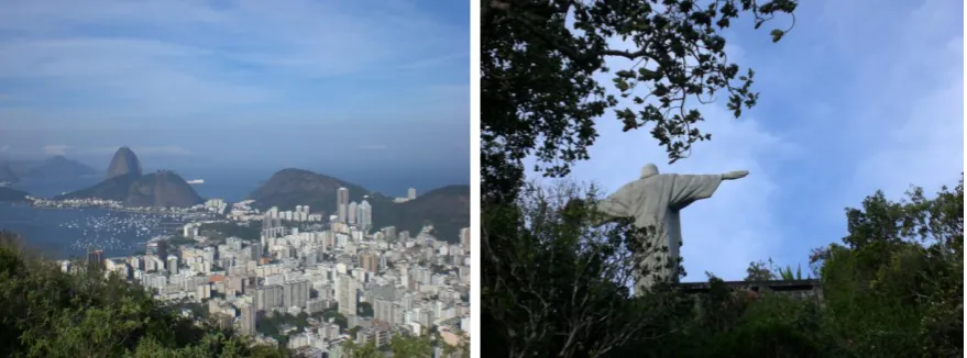
Rio de Janeiro is the second largest city of Brazil and has 7,3 million inhabitants. And in the metropolitan region of Rio de Janeiro live around 14 million people. The city is situated along the Guanabarra Bay and the Atlantic Ocean and squeezed into the valleys of the hills that surround the city. Rio de Janeiro is famous for its landscape, beaches and landmarks like the Christ redeemer statue and the Sugar Loaf mountain. But Rio de Janeiro is also known as one of the most violent city, mainly caused by drugs gangs that control the slums and the huge difference between rich and poor. The inhabitants of Rio de Janeiro are called Cariocas and they are like most Brazilians a joyful people. They show this through their music such as samba and off course during the carnival festivities.
[image:6.595.79.519.473.636.2]
6 1.2.3 Favelas
Rio the Janeiro is not only famous because of his beaches and the Christ statue, the city is also very well known because of it slums build on the hill sides. Because the slums are build on the hillsides they can be seen from everywhere in the city and this shows the sharp contrast between rich and poor. In Portuguese these slums are called favelas and they are collections of small houses constructed from simple materials and without basic facilities like electricity and running water . Originally the favelas were build on the hills near places where people could find work. Starting with building on the bottom of the hill and slightly building higher and higher. Because the enormous increase of people migrating to the city from poorer parts of Brazil in the seventies and actions taken by the government trying to clear some of the favelas on the hills people started to build new favelas on the outskirts of the city. These new favelas were build in flatter areas than the favelas in the city centre. In these new favelas the risk of landslides is smaller or non existing, but these new place were much further away from the city centre and the wealthy Zona Sul where most of the job opportunities are.
The favelas differ in appearance and size depending on their age and location. The older the favela is the more time the inhabitants had to improve their humble building. Nowadays most favelas exist of simple houses build from bricks and concrete and could even have several floors. Most of the improved favelas have running water and electricity and the main streets or alleys in these favelas are paved. But there are still favelas or parts of them where most houses consist of a few pieces of wood tied together and where the only roads are dirt roads. With the years the favelas started growing and now their size varies between a few hundred to half a million in the favela of Rochina. Which is one of the biggest slums in South America. In Rio de Janeiro one out of five inhabitants lives in a favela.
The view of the government towards the favelas, which has been one of denial, it is not strange that criminals and drug lords took power in this ‘safe havens’. In the favelas they formed a state within a state, with their own strict rules and without any control of the authorities. Most of the favelas in Rio de Janeiro are under control of drugs gangs . Three rivaling drug gangs operate in Rio de Janeiro: Commando Vermelho, Terceiro Commando Puro and Amigos dos Amigos. The main business of these gangs is drug trade and the processing of cocaine. From Rio de Janeiro a lot of cocaine is smuggled to the United States and Europe. The drug trade has a big impact on people living in the favela. Regular shoot-outs between traffickers and police and other criminals, as well as assorted illegal activities, lead to murder rates in excess of 40 per 100,000 inhabitants in the city of Rio and much higher rates in some Rio favelas. In the favela it is a normal sight to see young boys walking around with heavy guns, protecting the favela against any invasion from the police or rivaling gangs.
1.2.4 IBISS
7 In 1989 Nanko van Buuren and Jan Dam were both already active within the “De Waal foundation” and decided that, when the “De Waal foundation” withdrew from Brazil, they would continue helping the poorest and socially most excluded inhabitants of Rio. The initial projects that IBISS started targeted those (mainly children) who were living on the streets, because, for whatever reason, they had no other place to go. After a while Nanko and Jan realized that, in order to really help these people, they needed to go up a level and try to prevent or solve the reasons why people were being forced to live on the streets. This brought them into the favelas where, during the past 15 years or so, IBISS has started, and is still running, over 50 projects. All of these projects originated from the same ideal, but vary in approach to the diverse problems.
The projects ranged in focus from improving the living conditions in the favelas, such as ensuring running water and sewage, to educating young potential leaders who could improve the community from within. What started as a two-man operation soon grew and now IBISS is one of the most influential ngo’s in Rio with over 300 employees, many of whom belong or belonged to the target group of IBISS. IBISS operates in 37 favelas and manages to walk the thin line between the government and the various drug cartels that unofficially run the favelas.
With the constant aim to improve further the quality of life for the slum inhabitants, Nanko thought that there might be a way to help the target group save money on public transport and increase their opportunities. This could be achieved if the people have access to cheaper or free transport.
1.2.4 I-CE
I-CE (interface for cycling expertise) is a Dutch NGO for low cost mobility and integrated cycling planning. I-CE is an interface for the Dutch cycling capabilities and does this by different programs such as low cost mobility initiatives and the bicycle partnership program. I-CE also initiated the Cycling Academic Network to support their goals by scientific research. To support local authorities, society organizations and other partners I-CE started the Bicycle Partnership Program. With this program they want to help these authorities in the development or increase of the use of the bicycle as a transport mode. The program understands that by promoting the bicycle use by improving cycle-inclusive urban planning, it is possible to make a significant contribution to the poverty reduction by increasing urban low cost mobility, augmenting road safety and thus contributing to a better air quality, a more sustainable environment and a higher quality of life. The program acts in developing countries of Latin America, Africa and Asia1.
I-CE and IBISS are interested to combine their knowledge to fight poverty in the favelas of Rio de Janeiro. I-CE has already done some successful programs together with the municipality of Rio de Janeiro. Because IBISS has access to the favelas, where people have a lot of suspicion against authorities, this is for I-CE a way to reach the poor. For this research I-CE supported with technical knowhow about cycling.
11
8
2.
Research design
In this chapter the design of the research will be formulated. After an identification of the problems the research questions are given. To conclude this chapter the research approach and the techniques that are used are given.
2.1 Problem identification
In the previous researches that have been done for IBISS Vila Aliança seemed one of the areas in Rio de Janeiro with a high use of bicycles. People here are more used to use a bicycle but still a lot of people just see the bicycle as a toy for children and not as means of transport. For that reason IBISS wants to know what they can do for the cyclist and how they could make more people cycling. IBISS is interested in cycling because a lot of the faveladors, inhabitants of the favelas, work in the city center and have to commute for an hour or more. Most of the times they use multiple busses or bus and train to get to their destination. Because you have to pay again for every bus one takes this is uneconomic. By using a bicycle these people can skip a bus trip on their daily journey to work and so safe money. To achieve that more people will use the bicycle IBISS is interested in building a bicycle storage facility as has been done in Jardim America. Because already a lot of inhabitants of the favela cycle they are also interested in what can be done to make cycling safer and so lower threshold to start cycling. For that reason the practical objective of the research will be:
Point out where new bicycle storage facilities should be placed based on the origins and destinations of trips made by the inhabitants of Villa Aliança in the research area and making recommendations about improvements of the infrastructure to benefit the cyclists .
2.2 Research questions
The research questions that have to be answered are:
1. What are the main origins and destinations in the research area? 2. What are the main routes in the research area?
3. What is the demand for a parking facility at the destinations? 4. What are the main problems the cyclists face?
9
2.3 Research approach
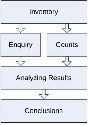
To answer the research questions the research has been divided into different steps. In the first step an inventory has been made of the research area, literature about cycling in developing countries and social data about the inhabitants of Vila Aliança. In the second step the information obtained in the first step has been used to hold an survey and to count the amount of cyclists on certain routes in the neighborhood. In the last two steps all information that has been obtained is analyzed and conclusions are drawn. Picture 1 gives a visualization of the steps that have been taken.
Inventory
Enquiry
Analyzing Results
Conclusions
[image:10.595.222.374.191.408.2]Enquiry
Counts
Figure 2: Research approach
2.4 Research techniques
To do the field research different techniques have been used to answer the research questions. Because the setting of the research is one with limited resources according to the I-CE Handbook should be strived for a suitable data collection that links questions and cost effective ways of obtaining them. This should be done by asking meaningful questions that can be answered by empirical, easily obtainable data. Quantitative data is used for scoring indicators. Qualitative data is useful for exploration and diagnosis and it can tell a story that cannot be deduced from objective measures. For this reason in the research quantitative as well qualitative methods are used.
10 strangers in their neighborhood and for that reason it is hard to deduct surveys inside the favela. For that reason is chosen to deduct the surveys just outside the favela. But in the end of the research it was possible to also deduct some surveys around the local football field.
To get a good insight into the potential of a bicycle storage facility counting the current number of bicycles parked at a certain place is needed. Counting of cyclists is also important to get an indication of the routes that are used by cyclists and what the amount of cyclists is on the road. These numbers could also help to convince local authorities that a substantial part of the road users are cyclists. Because at the moment local authorities do not include the bicycle in their planning.
Most of the used techniques are described in the Handbook for Cycling-Inclusive Policy Development developed by I-CE and different partners. In appendix A the different techniques are explained a bit more.
As the main goal of the research is to find out what kind of facilities are needed. It is important to find out what the latent need is of parking spaces for bicycles and what the traffic situation is on the routes used by cyclists. Counting of bicycle parking places and parked and chained bicycles shows this latent need. To get an idea of the latent need parked bicycles have been counted in the areas near the two train stations. In these areas also a lot of shops are situated. Bicycle (repair) stores have been counted to give an indication what level of service there is for bicycle users and inhabitants of the research area
2.5 The research methods in practice
As has been pointed out in the Research Design different techniques have been used to obtain the data. These techniques are observation, informal interviews, counting, a survey and a focus group to verify the obtained results.
Observation and informal interviews have been done during many visits to Bangu and Vila Aliança. During the start of the research this has been done in cooperation with employees of IBISS that live and work in the project area. Later on this has also been done individually, because trust within the community was created. Most observations have been done by walking through the project area and talking with shop owners and inhabitants of the project area. The project area is also several times explored by bicycle to get an idea of what cyclist experience and to find out what the most logical routes are to reach popular destinations.
At some places along the route traffic has been counted to give an impression of the number of cyclists that actually use the road. And to compare different routes with each other. These counts have been done in sets of one hour of counting. The counting has been repeated to make sure the outcome is valid.
11 After the collection of the data a feedback group has been organized in cooperation with the
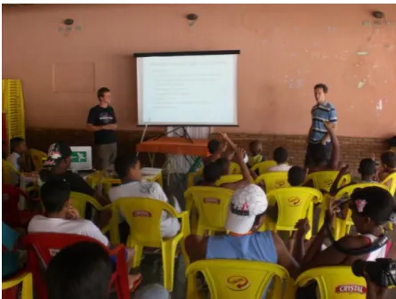
[image:12.595.70.293.187.355.2]employees of IBISS that are active in Vila Aliança. This has been done to show the community what the research was about and what the outcomes of the research were. For the research itself is was a check to see if the people that live in the project area agreed with the findings of the research. Besides the research that dealt with cycling in Rio de Janeiro a presentation has been given about cycling in the Netherlands. Many of the participants were very enthusiastic about this presentation and the use of the bicycle by the Dutch.
12
3.
Literature
In this chapter some general information about traveling in Rio de Janeiro, a model to analyze transport systems, and data about cycling in general will be presented. This information will give a view about what is known in literature and hand books and is useful in analyzing the transportation processes and systems in the project area and finding solutions.
3.1 Data on traveling in Rio de Janeiro
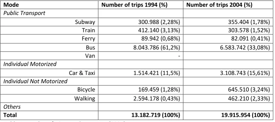
In the city of Rio de Janeiro daily 20 million trips are made2. Of these trips 33% is made by foot and 33% is made by bus. What makes the bus the most popular mode of public transport in Rio de Janeiro. Figures of the planning department of the city of Rio de Janeiro (PDTU) show that the traffic flows in the morning peak hours go from the suburbs into the city centre and in the evening peak hour they run the other way around.
Mode Number of trips 1994 (%) Number of trips 2004 (%)
Public Transport
Subway 300.988 (2,28%) 355.404 (1,78%)
Train 412.140 (3,13%) 303.578 (1,52%)
Ferry 89.942 (0,68%) 82.091 (0,41%)
Bus 8.043.786 (61,2%) 6.583.742 (33,08%)
Van -
Individual Motorized
Car & Taxi 1.514.421 (11,5%) 3.108.743 (15,61%)
Individual Not Motorized
Bicycle 169.459 (1,28%) 645.510 (3,24%)
Walking 2.594.178 (0,43%) 462.210 (2,33%)
Others
[image:13.595.65.542.307.518.2]Total 13.182.719 (100%) 19.915.954 (100%)
Table 1: Number of trips per day – PDTU (2004)
Concerning the use of the bicycle there are 5 parts of the city where the use of the bicycle is significantly higher than in other parts of the city where the daily number of trips is under 5000. These 5 parts are: Santa Cruz (43.459 trips), Campo Grande (32.831 trips), Realengo (25.377 trips) and Bangu (24.787 trips)3. All these parts lay in the west of the city where building is less dense.
2
PDTU 2004-Plano Direitor de Transporte Urbano da Regiao Metropolitana do Rio do Janeiro
3
13
3.2 Transport system
In society there is a certain demand for traveling, people want to travel from A to B. This demand is caused the difference in value experienced by an individual between the place where he is and the place he wants to travel to. A and B could for example be home and work. Going to work has a higher value because in that place one could earn money. This is the demand or need to travel. On the other hand is there the supply of transport. This means that it is possible to travel from A to B with a certain mode, for example by car, on a certain road. In the model different markets can be distinguished that all influence each other. These markets are the travel market, transport market and the traffic market. Figure 2 shows these markets.
[image:14.595.73.421.252.439.2]
Figure 4: The three markets of the transport system.
Demand, the travel market, depends on the activity patterns of the people living in a certain area, the spatial distribution and the spread in time of these activities. The supply depends on the
availability of modes in an area, the cost of these modes, the effectiveness, the efficiency and status of these modes. The demand and the supply come together in the traffic flows. For the flows aspects as the routes, speeds, congestion and safety are important.
To improve the transport system as a whole different interventions could be taken. Before
14
3.3 Aspects of Bicycle use
The bicycle has a lot of benefits for the individual user and for the society as a whole. There are also some barriers that could prevent people from using the bicycle. In this paragraph the main benefits and barriers are pointed out. In the recommendations these benefits and barriers are used to make measures that stimulate the use of the bicycle.
3.3.1 Benefits of bicycle use
Improvement of access and mobility choices
Cycling is much faster than walking and is an easy way to get around, especially in congested cities. The bicycle offers great reliability because you are not depending on time schedules or established routes. When cycling replaces walking accessibility and mobility improve. Using a bicycle one can easily move three times as fast as on foot and thus travel three times as far in the same time. This increases the area one can reach enormously.
Exercise and health
Riding a bike on a daily basis is an exercise that improves the health of the cyclist. A study done by the University of Amsterdam shows that a regular cyclist that cycles at least three trips of 6 km per week has the same health as someone ten years younger that does not cycle. Cycling also helps fighting obesity because cycling at a moderate pace needs the energy of approximately 600 calories per hour. Besides burning a reasonable amount of energy cycling also has a lot of other positive effects on the health of the cyclists such as the stimulation of endorphins, hormones that stimulate the feeling of well being, keeps muscles in a good condition, improves the regulation of cholesterol and blood pressure and this is all reached by just a simple exercise.4
Cost saving
After the initial investment of purchasing the bicycle cycling is a almost free means of transport. Repairing is relatively cheap, and with using the bicycle one can save money otherwise be spent on public or individual transport. This money can be spend on other goods or possibilities what increases the possibilities and opportunities of the cyclist.
Fewer emissions
Bicycles do not generate any air pollution and hardly any noise. By increasing the use of bicycles and diminishing the use of cars the emission of greenhouse gasses will be reduced what will contribute to slowing down global warming. On a local scale cycling will contribute to cleaner air. Especially for people with bad respiratory conditions and people with asthma this is a positive effect.
Better use of public space
Bicycles use the space on the road in an efficient way. Cyclists require less than one third of the space of the road. To park a car it requires fifteen times as much space as a bicycle.
Improving social equity
In large developing cities most of the poor live on the outskirts in low income settlements, far away from the centers of employment. To reach these centers people have to face long travel times and the cost for these trips are a proper amount the of the monthly family income. This is a huge burden
4
15 on the shoulders of the poor restricting their ability to participate in the work force, education and health care. The bicycle can play an important role in providing cheap and affordable transport for the poor.
Good combination with public transport
The bicycle is a very good means of transport to be used as a feeder transport for Public Transport such a bus and train. For many trips the destination is too far away to be reached by bicycle. In this cases the bicycle can be used to reach the bus stop or train station. This combination of bicycle and public transport can be a good alternative for the use of a private car. This because Public Transport on its own does not deliver a good door to door service, but in combination with the bicycle this problem is solved. To create a good connection between public transport and the bicycle it is important to have a good parking facility at the point where the transition is made from bicycle to Public Transport. This parking facility should not be too far away from the train station or bus stop. 3.3.2 Barriers to cycling
Poor road safety, insecurity and bicycle theft
When there are no facilities for cyclists they have to share the road with motorized traffic or cycle on the sidewalks. This can be dangerous and is unattractive. The cyclist is vulnerable between the fast moving traffic and on the sidewalk the cyclist gets in conflict with pedestrians and street vendors. Bicycle theft is also an important issue. Especially for poor people a bicycle is a large investment. If parking the bicycle is not safe the risk of theft becomes high. This is a powerful reason not to buy a bicycle or not to cycle.
Distance and physical limits
When distance become too long or the roads are too steep people will use other modes of transport, because in this cases cycling cost too much effort for them.
Climate and geography
When the weather is to hot cycling becomes unattractive. People do not want to arrive at their destination sweaty and wet.
Affordability and availability
16
3.4 Main requirements for cycle friendly infrastructure
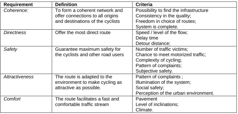
To improve the use of the bicycle an important part is the infrastructure on which the cyclist rides. Sometimes small improvements in the current infrastructure can make a large difference for cyclists. To see what are the most important requirements for cycle friendly infrastructure are the CROW has pointed out five aspects. In appendix E these 5 aspects are worked out.
To adapt infrastructure to cyclists it is important to keep the cyclist and its needs in mind when designing. The cyclist has some characteristics that make him different from other road users. These characteristics are:
The bicycle is muscle powered. So energy loss should be at a minimum
The bicycle requires balancing from its rider, so it needs enough space on the road
Cyclists are vulnerable because there is no crumpling zone.
Cyclist prefer a smooth surface because most bicycles do not have suspension.
Cyclist ride in open air, so if possible protection against wind, rain and sun is needed.
Cycling is a social activity and cyclist want to ride side by side. Especially for parents that escort their children.
Cycling is a multitasking activity so designers should keep this in mind and avoid complex situations.
The 5 requirements for cycle friendly infrastructure are given in table 2:
[image:17.595.99.498.442.634.2]
Table 2: requirements for cycle friendly infrastructure
Requirement Definition Criteria
Coherence: To form a coherent network and offer connections to all origins and destinations of the cyclists
Possibility to find the infrastructure Consistency in the quality; Freedom in choice of routes; System is complete. Directness Offer the most direct route Speed / level of the flow;
Delay time Detour distance;
Safety Guarantee maximum safety for
the cyclists and other road users
Number of traffic victims; Chance to meet motorized traffic; Complexity of cycling;
Pattern of complaints; Subjective safety. Attractiveness The route is adapted to the
environment to make cycling as attractive as possible.
Pattern of complaints ; Illumination of the system; Social safety;
Perception of the urban environment. Comfort The route facilitates a fast and
comfortable traffic stream
17
3.5 Cycling in Rio de Janeiro
Rio de Janeiro states itself as the cycling city of Brazil. And indeed cyclists are not totally a strange phenomenon in the city. Spread over the city are more than 140 kilometers of cycle tracks and the bicycle is becoming more and more popular. In appendix D a map with all cycle tracks in Rio de Janeiro is provided. Despite of the many kilometers of cycle tracks the model share of the bicycle still is only 3%5 in Rio de Janeiro. In this part will be pointed out the difference in cycling in the different areas in Rio de Janeiro. Most of the people that cycle in the South Zone, the richer part of the city do this for leisure purposes. There are perfect cycle tracks along the beaches of Copacabana and Ipanema where people cycle on nice bicycles and use the bicycle as a certain lifestyle. In the different neighborhoods are cycle tracks, but these tracks are not always connected to each other and the size and shape differs. Some are very good like the ones along the beaches, around Lagoa and in the Flamengo Park. Others are of bad quality or are painted on pavement so people walk on the cycle track or there are even terraces standing on the cycle track. As you can imagine these kind of cycle tracks are hardly used. In places where there are no or just bad cycle tracks cyclist use the road to cycle. The road system is mainly designed for cars and is in many places a one way system. Drivers are not really used to cyclists on the road, so cyclist have to ‘fight’ for their place on the road. This means that cyclists cycle on both sides of the road and also against the traffic flow. Unlike the Netherlands most cyclists prefer to cycle on the left side of the road of the road. This is because on the right of the road busses stop which conflicts with cycling.
Figure 5:Different kinds of cyclists in downtown Rio de Janeiro
5
18
4. Data findings
This chapter goes into the conducted field research and the findings that were made in the research area. For the presentation of these findings the travel model presented in the previous chapter will be used. First an introduction about the area will be given. Next the travel market is described. This means the trips people in the research area make and how they are related to the spatial distribution, the activity patterns and the spread in time. Than the transport market will be analyzed. Which modes are available and what is the efficiency, status and costs of these modes. Finally we look at the flows in the neighborhood. Here important questions are what are the routes, speeds and safety in the neighborhood.
4.1 The research area
[image:19.595.69.463.322.573.2]The project area is situated in Bangu. Bangu is a residential area in the western part of the city of Rio de Janeiro. Bangu is about a one hour drive from the center and can be reached by car or by bus over the motorway Avenida Brasil or by train to Campo Grande and Santa Cruz. In the whole Bangu area live 659.649 people and the area is with 77 inhabitants per hectare one of the least dense inhabited areas within the city of Rio de Janeiro .
Figure 6:Location of Bangu in Rio de Janeiro
In colonial times the area was an estate, Fazenda Bangu, founded by the Jesuits from Santa Cruz. In the end of the 19th century a textile factory was build on the estate by the English firm Morgan Snell and company near the just build railroad. This fabric brought a lot of employment to the area what started the region to urbanize. For a long time the factory was a stable factor in Bangu. But in the 1980’s there was a decline in the production and eventually the factory closed in 1995. Since a few years the factory has been renovated and now houses a modern shopping mall. Bringing new employment and attracting visitors from the whole city.6
6
19 The neighborhood of Bangu is a more residential area where most people live in houses. This unlike the centre and the south zone of the city where most people live in apartments. The neighborhood is cut in two by the railway track that runs from east to west.
The project area is limited by on the south site the railway line and on the north side Avenida Brasil, a large express way. From east till west the project area spreads from the Bangu train station until the train station of Senador Camará the distance between them is 2,5 km. In the area are situated the favela Vila Aliança, the asfalto of Vila Aliança and other residential buildings. The project area is shown in figure 3.
[image:20.595.71.502.311.697.2]The centre of the neighborhood is the area around the Bangu train station. The train station is situated above the tracks as a bridge that connects both sides of the railway tracks. And on both sites of the railway tracks shops are located. The south site is the more richer part and the shops here are more luxurious. Here is also shopping Bangu, a shopping mall that is located in the old textile factory. On the north side are a big supermarket, different banks and a small bus station. From the bus station busses leave to the centre.
20 The Favela of Vila Aliança lies a bit west from the Bangu train station and north from the railway tracks. According to IBISS around 40.000 people live in Vila Aliança. The buildings in the favela are build from characteristic red bricks and most houses have running water and electricity. In the favela also a few small shops can be found where groceries are sold. Along the railway tracks is a part of the favela where housing conditions are very bad, here people live in small sheds made from pieces collected wooden plates. People in this part of the favela even have to cook on the street. The big difference between the asfalto and the favela is that the favela is under control of a drugs gang. The entrance roads of the favela are blocked with pieces of wood and debris. Also on the outside you can see the guards of the favela. These are young boys with walkie talkies that keep a close look on the streets to see who is going in and out the favela and to warn when police or a rivaling gangs come close. Inside the favela gang members walk around with machine guns to protected their drugs selling points and factories. Very often the police comes into the favela with special heavily armored cars to arrest gang members or confiscate drugs or special weapons. Most of the time this is accompanied with a lot of violence and at those times the situation in the favela is one of an urban war. Shootings can go on for hours, and most of the casualties are innocent children playing on the street at the moment the police arrives. In the period that this research was conducted two little children were killed by police fire in the favela.
4.2 Travel Market (Trips)
4.2.1 Activity patterns and spread in time
The most important activity patterns are traveling for work or education. Most people that live in Vila Aliança have to struggle to survive. Jobs they have are for short terms and for a low or minimum wage. A minimum wage is R$ 487,507 what is € 190,-. For most man jobs are located in the north west of Rio de Janeiro or in the city centre. In the north west of Rio de Janeiro the harbor and many factories are located. Also in Madureira, a part of Rio de Janeiro in the north of the city, a lot of factories are located. Also some men work on construction sites on different locations in Rio de Janeiro. The women that have jobs work in the city centre or the more wealthy neighborhoods along the coast. Here they have jobs in shops or cleaning of offices or houses. Not all women work, because they have to take care of their children. Most people leave between 6 and 7 o’clock in the morning and return in the evening around 7 and 8 o’clock at home. The journey they make to reach their jobs costs them between 1 and 2 hours. Most people do not work on the Saturday afternoon and on Sunday. In Brazil unemployment is around 8% but in the favelas this number is higher. There are no exact data about the unemployment in the favelas but according to staff of IBISS this number is around the 20%. Primary schools start at 9 o’clock in the morning and classes are finished at 4 o’clock in the afternoon. For teenagers it is very common to have a job during daytime and go to school in the evening. Because the schools offer classes for the younger children during daytime and for older children in the evening.
7
21 4.2.2 Spatial Distribution
Vila Aliança is situated along the railway track, that runs from the city centre to Santa Cruz, between two train stations. The Bangu station and the Senador Camará station. North of the area lies the Avenida Brasil, the express way that runs from the city centre to west of the city. Around the stations are commercial activities located. On the other side of the railway track is a newly build shopping mall, shopping Bangu, located. Between the train stations run two main roads. Along these roads all kind of small shops can be found such as bicycle repair shops, bars, beauty salons and grocery stores. The project area consists of different parts of development. Near the station of Bangu there is a shopping street with a supermarket, different stores and different banks. Around this shopping area mainly normal detached houses, shops and small companies are situated. Going more west further away from the station the houses start to change and become more basic and are all build from the typical red bricks. This part is called the asfalto. The word asfalto means that instead of the favela this part of the neighborhood has paved roads. Moving more west the asfalto becomes the favela. Some parts of the favela look the same as the asfalto and like the houses in the asfalto al houses in the favela are build from the characteristic red bricks. In the favela are some small shops and there is a football field. There is no medical post in the favela. More to the west the favela ends and the asfalto goes on. Here on the border is also the main street of Vila Aliança. With a bar, small shops, including one for groceries, two bicycle repair shops, and an old samba school. In this samba school, that consists of a big square with a roof on it, IBISS organizes drumming classes for the children of the favela, but the location is also used for parties organized by the drugs gang. Close to the Senador Camará station the houses start to become better again. In the area are also some small parts with bigger and nicer houses. These parts have streets that are closed with a fence and have guards hired by the residents to protect their property.
[image:22.595.69.376.445.719.2]
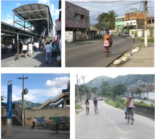
Figure 8:
Images from the research area clockwise: -Bangu train station and shopping street -Street in the asfalto
22 In the project area different services can be found. There are five schools. In appendix G the schools are shown on the map of the research area. Three of them are primary schools one is a high school and one is called collegio, this is a mixture between a high school and vocational. The primary schools mainly attract children that live in the project area. The collegio attracts students from whole Bangu and also from other neighborhoods, like Realengo and Campo Grande. Larger supermarkets can be found near the train stations of Bangu and Senedor Camará and there is one just north of the favela. Along the main roads all kinds of smaller shops can be found. The commercial activities in these shops are very broad and consist of: groceries, bars, internet cafés, garages, bicycle stores, beauty salons and hairdressers. For leisure there are several football fields in the project area, one is situated in the favela. Near the station of Senador Camará there is a gym. Like everywhere in Rio de Janeiro also in the project area are a lot of churches. Most of them are build by evangelical Christians and are situated in all kind of halls instead of the traditional cross shaped buildings.
4.3 Transport Market (Transport Systems)
4.3.1 Available modes
As has been pointed out in the part about the spatial distribution Vila Aliança is situated close to the railway and motorway to the city centre. And although it takes about an hour of traveling the city centre can be reached quite easily. In this paragraph different modes that are available to the inhabitants of Vila Aliança will be discussed.
Walking
[image:23.595.69.275.500.650.2]Walking is an important mode of transport for the inhabitants of Vila Aliança. It is free and still a lot of destinations in the research area can be reached. In the survey 60% of the interviewees indicate that they go by foot to the train station. This walk cost them 20 minutes. The quality of the sidewalks in the neighborhood differs. Most of them are made of asphalt and are wide enough to provide enough space for pedestrians. These are mainly found near the two train stations and along the main routes. In other places the sidewalk is not more than dirt along the road.
Figure 9:Pedestrians on the sidewalk
Bus
23 bus depends on the time of the day and vary between 40 minutes and 1 hour and 10 minutes. Close to the Bangu train station is a small bus station which is also the end of these lines. The price of the bus is fixed and is R$2,20. Among inhabitants of Vila Aliança the bus is a popular means of transport. Almost 50% of the interviewees indicates to use the bus on a regular basis. Another 40% indicates to use it now and then.
[image:24.595.70.457.157.300.2]
Figure 10: The bus from the city centre to Bangu and a bus driving through the neighborhood
Van
Vans are small busses that drive certain routes and try to fill the gap of where busses do not go. The status of these vans is unclear and it is not sure if they are legal or not. They also vary a lot in quality, some are pretty comfortable others are very unsafe. Most of the time the vans are packed with people and more than 20 people in these vans with thirteen seats is not uncommon. The price of a trip with a van is R$2,00, just under the price of a bus. But for longer trips the price could be higher. In Vila Aliança different Vans are active. A popular line is the line between Campo Grande and Vila Kennedy to neighborhoods close to Vila Aliança. There is also a van service between the station of Bangu and Vila Aliança to bring people with their groceries back home. In the survey 18% of the respondents indicates to use the van on a regular basis.
Figure 11: Vans in Vila Aliança and the center of Bangu
Train
[image:24.595.70.466.499.645.2]24 stations and trains that stop at all stations. The exact lines can be seen in appendix C. The travel time between the station of Bangu and Central do Brasil is 50 minutes and trains run every 30 minutes. The price for the train is fixed and is R$2,20. During rush hours the trains can be very crowded and packed with people. At the end of a working day thousands of people try to enter the trains and try to conquer a place to sit. This can be pretty rough with a lot of pushing and people jumping through the windows of the train. The survey held among the residents of Vila Aliança shows that 12% of the interviewees uses the train on a regular basis.
Taxi and Motor Taxi
In Bangu and Vila Aliança taxis are active. But most inhabitants only use them for special occasions as they are too expensive for them. Instead of normal taxis a lot of motor taxis are present in the neighborhood. Motor taxis are just a motorbike with a driver on which you can hop on the back. For trips within the neighborhood the fare is R$2,00. As the neighborhood is not very large most trips only take a few minutes. If you compare the distance traveled with the price paid these trips are relatively expensive. In Vila Aliança are 7 motor taxi stands. These stands are places from where a group of motor taxis operate. These groups are organized and they share their profit. Sometimes they have a micro credit that made it possible to buy the motorbikes. 13% of the interviewees indicates to use the motor taxi now and then. For most people using a motor taxi it is also a status symbol, because on the back of the motor you are very visible.
[image:25.595.78.477.368.520.2]
Figure 12: Motor taxi and motor taxi stand
Car and motorbike
25
Figure 13:A car in the asfalto of Vila Aliança
Bicycle
In Vila Aliança many people cycle and the bicycle is present on the street. According to the survey almost 75% of the families owns a bicycle. The reason why people in this part of the city are more used to the bicycle is that in the past they used the bicycle to go to their work in the nearby textile factory. Together with the high use of bicycles there are also a lot of bicycle shops and bike repairers in Bangu and Vila model is designed for women but is used by both men and women. The bicycle has thick tires what makes it more comfortable to cycle on a bad road surface. The prices for new bicycles are around R$ 400,- but a second hand bicycle is available from R$ 80,-. Repairs on the bicycle cost a few Reais. Repairing a flat tire for example costs R$2,-
[image:26.595.74.497.413.571.2]
26
4.4 Traffic Market (Flows)
4.4.1 Main Routes
[image:27.595.70.418.272.561.2]The most important routes in the project area are from centre of Vila Aliança to the main roads that surround it. Through these main roads the two train stations can be reached. In figure 7 these routes are indicated with the green (Estrado do Taquaral), red (Estrado do Engenho) and light blue (Rua Dr. Augusto Figueiredo) lines. And from these main roads also the Avenida Brasil motorway can be reached. These main roads are made of asphalt and are about 7 meters wide. In Bangu especially around the train station of Bangu some streets are one way streets to regulate the traffic. These streets are indicated on the map with the blue (Rua Sul America) and orange (Rua Cel Tamarindo) line. In rush hours the roads around the train station can be a bit congested. To regulate the speed of the traffic everywhere in the project area speed bumps can be found. On quiet roads as well on the main roads. These speed bumps are made of concrete and are about 10 cm high.
Figure 15: The main routes in the research area
4.4.2 Cycling Routes
To go to the train station of Bangu cyclists choose for direct and safe routes. Cyclists ignore the one way directions on most of the one way roads around the station of Bangu. Observation and counts also showed that cyclist choose a route along roads with hardly any car traffic instead of using the main roads with a lot of car traffic and heavy traffic. Counting shows that on some parts of the main routes to the station of Bangu only 40 cyclists per hour pass. On the quiet routes towards the station of Bangu pass 90 cyclists per hour.
27 has traffic lights. Beside this crossing there are some other crossings in the area where a stream of cyclists want to cross a busy road and comes in conflict with faster traffic. The interesting thing is that the inhabitants do not see these crossings as dangerous. In their eyes these crossings are only dangerous when police wants to enter the favela and gets in an armed conflict with gang members.
Figure 16:Crossing with traffic lights
4.4.3 Social Safety
People do not feel unsecure when it is dark. The survey shows that 80% of the interviewees would cycle when it is dark. In Rio de Janeiro sunset is between 6 and 8 o’clock depending on the season. Lightning on the bicycle is very uncommon, but some bicycles have reflectors. People worry more about conflicts between the police and the drugs gang because they feel that as insecurity.
4.4.4 Parking
28
Figure 17: Parked bicycles at the Bangu train station.
The situation at the Senador Camará train station is a bit similar to the around the station of Bangu. But this station is a bit smaller and around this station are only a few shops. Counting here shows an average of 70 bicycles parked. The difference with the situation at the Bangu station is that that here the bicycles are parked in an concentrated area. Also social security here is higher, because in front of the place where the bicycles are parked a motor taxi post is situated. Here are until the beginning of the evening people present that have an eye on the parked bicycles.
[image:29.595.70.473.385.536.2]
29
4.
Conclusions and recommendations
In this chapter the conclusions of this report will be presented. First the research questions will be answered followed by the conclusion concerning the research problem. In the second paragraph the conclusions will be discussed followed by some recommendations.
5.1 Answers on the research questions
RQ 1: What are the main origins and destinations in the research area?
The whole research area exist of residential areas and can thus be seen as a origin. To make it more precise we can distinguish four exact origins. These are the residential area around the train station of Bangu, the favela of Vila Aliança, the asfalto west from the favela and the residential area north of the favela. The main destinations in the research area are the train stations of Bangu and Senador Camará, Shopping Bangu, the mall on the other side of the railway tracks, and the schools in the research area.
RQ 2: What are the main routes in the research area?
[image:30.595.73.470.429.670.2]The main routes in the research area are from the residential areas to the main routes and from there to the train stations. Figure 7 shows these routes. Cyclists also use smaller roads with less motorized traffic to avoid dangerous situations. Figure 10 shows, indicated by the black arrows, the road that has a dead end for cars and is used by cyclist to have a safe alternative for the main road indicated by the red lines. The cyclists use the road indicated by the yellow lines to continue their route to the station of Bangu.
30 RQ 3: What is the demand for a guarded parking facility at the destinations?
The demand for a guarded parking facility on the north side of the Bangu train station is between 100 and 150 bicycles. At the moment on average 200 bicycles are parked in front of the station. In the survey 50% of the interviewees indicates that they are willing to pay for a guarded storage facility. The survey also shows that many people are afraid that there bicycle will get stolen when they park it at one of the train stations. This creates a demand for guarded parking of bicycles. Other guarded parking facilities such as the ones in Santa Cruz show that it can be very successful and profitable. For most users in Santa Cruz it does not seem a problem that the facility is about 200 meter away from the train station.
RQ 4: What are the main problems the cyclists face?
The main problems cyclists face are road safety, bad road surface, bicycle theft and a lack of places to park their bicycle at the train stations.
Bad road safety is caused by the fact that cyclists have to cycle between faster traffic and they do not have a designated space on the road. Most drivers do not respect cyclist on the road what makes that they start to cycle on the sidewalk. This partly causes the complaints about the bad road quality. Most roads are not in a very bad condition and even in the favela most roads are paved. But when cyclists have to cycle on the side walk this are mainly muddy places what makes cycling uncomfortable.
Another problem is the lack of places to park a bicycle at the train stations. At the Bangu train station this is an urgent problem. During daytime the available bicycle racks are full and people chain their bicycle to the pools of the sunroof. This makes that the whole shopping area is full with bicycles. This also makes it attractive for thieves to steal the bicycles. In the whole neighborhood of Bangu this is a serious problem.
RQ5. What are the main benefits of cycling for the inhabitants of Vila Aliança?
31
5.2 Overall conclusion
5.2.1 Parking Facilities
The most important point of attraction in the research area is the train station of Bangu and the shops around it. Most inhabitants of Vila Aliança come here to do their shopping and if they take the train most of them do that at this train station. Here is also a large potential demand visible. Already more than 200 bicycles are parked here every day and this in combination with the high risk of theft of the bicycle creates a demand for a guarded bicycle facility. The risk of theft is also an important reason not to cycle for many people so taking this risk away will improve the use of the bicycle. For that reason starting a guarded parking facility at the Bangu train station will be a good solution for the inhabitants of Vila Aliança.
[image:32.595.74.517.410.581.2]The difficult part however is where to situate this guarded parking facility. At this moment cyclists can park their bicycles in front of the station and the shops, so a facility to far away from the station and the shops will not be attractive. For that reason the storage facility should be in the shopping street close to the train station. The only suitable place is in the unused corner in front of the Guanabara supermarket. Starting a guarded parking facility here should be done in cooperation with the supermarket. A good example of this kind of cooperation is the Bangu Shopping mall on the other side of the railway tracks. Here a free guarded bicycle storage facility is provided for the visitors of the shopping mall. Pictures of this bicycle storage facility are in appendix H. The parking facility should be a simple facility with a small fence behind which the bicycles can parked, this because there is no enough space to build an indoor facility.
Figure 20: The unused corner in front of the supermarket indicated on the map by the red circle.
32 5.2.2 Cycle lanes and completeness of the cycle network
To make sure that not only at the destinations problems are solved for the cyclists also along the routes barriers for cycling should be taken away. The main barrier here is the insecurity for cyclists while on the road. Cyclist do not have a designated space on the road and are sometimes forced to cycle on the sidewalk. To change this situation on the main routes bicycle lanes could be created. This makes drivers of cars aware of the space of cyclists on the road and shows the presence of bicycles. In the one way streets the cycle lanes can be used to create space for the cyclists where they can cycle against the current. Examples of these cycle lanes are show in Appendix I.
Creating bicycle lanes also could complete the network of bicycle paths that already exists in Bangu. In the area east from the Bangu train station are already large parts with cycle tracks. In Campo Grande the part of Rio de Janeiro west from Bangu also large parts with cycle tracks exist. Creating bicycle lanes in Vila Aliança is not only good for people that just want to make small trips in Vila Aliança but also makes the total cycle network more coherent. A coherent network creates the possibility to cycle further and reach for example destinations, like work, that otherwise seemed too far away. This creates new opportunities for the inhabitants of Vila Aliança and they can save money they otherwise spend on public transport.
[image:33.595.71.276.336.492.2]
Figure 21: A cycle path in the western part of Bangu
Not only the cycle lanes could show road users the place of cyclists on the road but also on crossings that are used by a lot of cyclists signs on the road could be made. These signs could form a path of white squares showing that cyclist cross the road at that point. A crossing that is eligible for these kind of signs is the crossing of Estrada do Engenho with Rua do Corredor. In picture 7 this is where the red and the turquoise lines cross. At this crossing a lot of cyclists that use the quiet roads have to cross the busy Estrada do Engenho to enter the favela.
33
References
Allin, P & Van der Hoek, J. Internship report on the possibilities for the bicycle in Rio de Janeiro, 2006. Grosvenor, T. Qualitative Research in the Transport Sector, 2000.
I-CE Cycling-Inclusive Policy Document: A Handbook, 2009
Prefeitura da Cidade do Rio de Janeiro – Nota Technica 11: Bangu
Prefeitura Transportes PlanoDiretor de Transportes da Cidades do Rio de Janeiro, 2004.
www.cycling.nl
www.ibiss.info
http://www.rio.rj.gov.br/
34
Bachelor Report
Cycling in Vila Aliança
Appendices
30-11-2009
Author
W.J. Huisman (0065692)
Supervisors
Dr. N.G. van Buren (IBISS)
Drs. R.P. Hulleman (ICE)
35
Appendix A - Research Techniques
Observation
Observation is a qualitative technique and has been used to get an idea of the main origins and destinations in the research area. Obtaining a lot of data on origins and destinations is mainly important in larger cities. In small cities and smaller areas such as the research area there are only a few origins and destinations and routes. According to the I-CE Cycling Handbook an analysis of OD flows is not necessary in such a case. In this case the OD’s can be listed through site visits and through OD mapping. This is less accurate but gives in small area a sufficient idea of the origins, destinations and routes. Because the main origins are the residential areas and in the case of this research the favela and the main destinations are shops and places where shops are concentrated, train stations and bus stops.
Informal conversational interview
An informal conversational interview is an interview in which the interviewee does not know that he is been interviewed. The interviewer just starts a conversation and asks in this conversation about certain topics he is interested in. In the case of this research that means that shop owners, staff of the NGO and other important people in the research area are being ask about certain topics concerning traveling and using the bicycle. Rubin and Babbie (1993) say that you can use this method the best when you want to maximize your understandings of what you are observing and would like to hold a focus-group within this case. The good thing about these kind of interviews is that the interviewee is at ease and can speak openly. There is not the pressure of a formal interview what could withhold the interviewee of giving answers that are maybe socially not wanted. In the research this kind of interviews have been used to get an idea of the research area and what is going on. Together with the information obtained from the observations the information from these interviews had been used as an input to design the survey and determine where counts have to be done.
Survey
36 Traffic counting
Counting traffic can be done in different ways. The I-CE Handbook states: “This can take the form of screen line counting in one or both directions and stream counting at intersections. In stream counting at intersections, for every leg of the intersection, the streams in different directions are counted. One drawback is that, in busy intersections, it can be quite difficult for one person to count the different streams from one leg, so more persons per leg are necessary.” That is why according to the I-CE Handbook screen line counts are easier but a drawback is that they also result in less information. For this research the traffic counts are used to get an idea of the number of cyclists on the main routes. In a next phase these numbers can be used to convince the local authorities that there are proper amount of cyclists using the roads. Because in most cases local authorities have no idea about cyclist and the number of cyclists on the road. For that reason screen line counts in two directions have been done. The best period to do traffic counts is during peak hours. The I-CE Handbook says about counting periods: “As for counting periods, it is good practice to use peak periods on ordinary weekdays and to repeat counts for at least one other week in the same period of the year. Counting in peak periods produces a fair idea of peak cycle demand.” During the research counting has been done during the beginning of the afternoon, as this is during daytime a peak period.
Facility counts
37
Appendix B - Conducted Survey
PESQUISA SOBRE TRANSPORTE NO BAIRRO
O perfil do visitante
10. 1. Sexo: Masculino Feminino
11. 2. Sua idade: 0-20 20-30 30-40 40-50 50-60 60 e + NR 12. 3. No total, quantos pessoas moram em sua residência:
Moro: só 2 3 a 4 5 e mais 13. 4. Onde você morra? Qual bairro:
Algumas questões sobre seu transporte
5. Quais veículos estão disponíveis para você?
Veículos Você tem? Quantas vezes por semana você usa? Automóvel
Motocicleta Bicicleta
6. Qual transporte você usa?
Veículos Você usa? Quantas vezes por semana você usa? Ônibus Van Moto táxi Trem Metrô Outros
7. Quantas conduções você uso pra ir pro trabalho/escola? 8. Qual e o destino de suas viagens?
Destinos Você vai pra: Quantas vezes por
semana?
Estação Bangu
Lojas perto de Estação Bangu Estação Senedor Camerá Lojas perto de Estação Senedor Camerá
Lojas aqui na comunidade Shopping Bangu
38
Algumas questões sobre o trem
9. Quando você usa o trem, qual estação você mais usa?
Bangu Senador Camará Outra 10. Você vai ate a estação de trem:
A Pé
De Bicicleta De Moto-taxi
De Ônibus
De Van
Outros
Algumas questões sobre a bicicleta
11. Porque você usaria a bicicleta e porque você não usaria a bicicleta? Classifca as razões com 1 (não importante), 2 (pouco importante), 3 (importante), 4 (muito importante).
Usar bicicleta Classificação Não usar bicicleta Classificação
Saudável Risco de furto
Rápido Chuva
Barata Vou suar muito
Fácil Pouco seguranca no
trânsito
12. Classifica os principais problemas para ciclistas no bairro com:
1 (não é problema) 2 (pouco problema) 3 (problema) 4 (grande problema)
Problemas Classificação
Falta de estacionamento Quebra molas
Risco de Furto
39
Algumas questões
sobre o transito e bicicleta10. Se eu tiver que pagar 1 Real para guardar sim não minha bicicleta, eu prefiro parar em outro lugar.
11. Se eu vou ate a estação de trem de bicicleta, sim não não tem lugar para guardar minha bicicleta.
12. Eu vou ate a estação de trem com uma sim não bicicleta velha porque se eu for com
uma nova vão roubar
13. Eu prefiro andar de bicicleta na calcada sim não
14. Eu ando de bicicleta a noite sim não
15. Quando eu paro perto da estação de trem em sim não Bangu, tem grandes chances de minha
bicicleta ser roubada
16. Quando eu paro perto da estação de trem em sim não Senador Camará, tem grandes chances de minha
bicicleta ser roubada
17. Os motoristas respeitam os ciclistas quando eles sim não estão andando de bicicleta na rua
18. Aqui no bairro os carros andam muito rápido, sim não e por isso não é seguro andar de bicicleta
19. Quebra-molas não são bons para quem anda sim não de bicicleta
20. Tem muitos cruzamentos perigosos aqui no bairro sim não
21. Um cruzamento com sinal é seguro para se sim não atravessar de bicicleta
40
Translation of the survey about transport in the neighborhood
Profile
14. 1. Sex: Male Female
15. 2. Age: 0-20 20-30 30-40 40-50 50-60 60 e + NR 16. 3. How many people live in your family:
I live: alone 2 3 a 4 5 and more 17. 4. Where do you live? Which neighborhood:
Some questions about you transport
5. Which modes are available for you?
Vehicles You have? How many times per week do you use it? Car
Motorbike Bicycle
6. What types of transport do you use?
Modes You use? How many times per week? Bus
Van Motor taxi Train Metro Others
7.
8. What is the destination of your trip?
Destination You go to: How many times per
week?
Bangu train station
Stores at the Bangu train station Senedor Camerá train station
Stores at the Senedor Camerá station Stores in the neighbprhood
Shopping mall Bangu
Work/ School in the neighborhood Work / School outside the
41
Some questions about the train
9. When you use the train which station do you use?
Bangu Senador Camará Other 10. How do you go to the train station:
Walking
Bicycle
Motor-taxi
Bus
Van
Other
Some questions about the bicycle
11Why to use or not use the bicycle
1 (not important), 2 (little important), 3 (important), 4 (very important). Using the bicycle Classification Not using the
bicycle
Classification
Healthy Risk of theft
Fast Rain
Cheap Sweating
Easy Little safety on the
road
12. Rank the problems for cyclists in the neighborhood:
1 (not a problem) 2 (small problem) 3 (problem) 4 (big problem)
Problem Classification
Lack of parking space Sleeping policeman Risk of theft
42
Some questions about traffic and the bicycle to answer with yes or no
23. When I have to pay 1 Real to park my bicycle, I prefer to park on an other place. 24. When I go to the