JOURNAL OF FOREST SCIENCE, 63, 2017 (11): 496–502 doi: 10.17221/99/2017-JFS
Evaluating the effect of biological stabilization
on landslide control at the edge of forest road
Seyed Ata Ollah HOSSEINI
1*, Elham Fazeli SHAHROODI
2, Majid LOTFALIAN
2,
Aidin PARSAKHOO
31 Department of Forestry and Forest Economics, Faculty of Natural Resources,
University of Tehran, Tehran, Iran
2 Department of Forestry, Faculty of Natural Resources,
Sari Agricultural Sciences and Natural Resources University, Sari, Iran
3 Department of Forestry, Faculty of Forest Sciences,
Gorgan University of Agricultural Sciences and Natural Resources, Gorgan, Iran *Corresponding author: [email protected]
Abstract
Hosseini S.A.O., Shahroodi E.F., Lotfalian M., Parsakhoo A. (2017): Evaluating the effect of biological stabilization on landslide control at the edge of forest road. J. For. Sci., 63: 496–502.
Landslide is one of the negative sides of building non-standard roads in forest areas. The aim of the present study was to assess the effect of biological stabilization on landslide at the edge of forest roads in south and north aspects. For this purpose, in Neka forest (Mazandaran province) three treatments including control, sliding and stabilized areas covered by 35-years-old even-aged alder trees were selected. Benchmarking and soil sampling were conducted during three periods including July, November after rainfall events and March after rainfall events. The results showed that the mean movement of landslide in north direction was 9 cm, while this value was 6 cm in south direc-tion. Sliding in north direction was 32% more than that in south direcdirec-tion. Biological stabilization by alder in north and south direction caused a 33 and 66% reduction in landslide movement, respectively. The characteristics of soil mechanics were different between stabilized and sliding areas. Besides, the soil texture in north direction for control and stabilized areas was clay with high liquid limit (CH) and for sliding area it was clay with low liquid limit, while this value in south direction was CH for three treatments of control, stabilized and sliding areas. To plan biological stabilization, the mechanical characteristics of soil, site features, and appropriate plant species should be considered as important factors.
Keywords: sliding area; stabilized area; alder trees; soil mechanics; benchmarking
Forest roads are the most eminent means of ac-cess to forest (Leung et al. 2015). Besides, these roads are constructed in order to provide sustain-ability and access to forest lands for managing activities, utilization, wood transportation, for-est conservation and forfor-est planning (Hasmadi et al. 2008). Landslide in various aspects of forest roads causes direct and indirect damage such as restrictions on forest management and utilization, and habitat destruction and degradation (Ashish
Pollen 2007). Main and detour roads of moun-tainous regions are among the most sensitive fac-tors in all projects and lack of attention to this is-sue will result in irreversible damage (Preti et al. 2010; Rees, Ali 2012). Therefore, bioengineering is one of the most effective ways to stabilize the long and steep slopes which is affordable (Lewis et al. 2001). The mechanism of this method is the use of vegetation to reduce instability and erosion.
Vegetation can improve the strength of slopes prone to instability through root reinforcement (de Brito Galvão et al. 2010). Voottipruex et al. (2008) reported that Vetiver grass roots increased the soil strength 1.5 times and Aca-cia tree roots increased the soil shear strength 3 times. Plant roots reinforce the soil by increas-ing the soil-root friction and cohesion and conse-quently improving the soil shear strength (Oper-stein, Frydman 2000; Schmidt et al. 2001; Reubens et al. 2007; Stokes et al. 2009; Abdi et al. 2010). Various studies have been conduct-ed in different parts of Iran (Ahmadi, Talebi- Esfandarani 2002; Abedi et al. 2010; Hossei-ni et al. 2011; Nazari et al. 2011). These stud-ies have shown the significant factors such as liq-uid and plastic limits in sliding areas. Lako and Marko (2012) showed that slope and human in-terference are the important factors in soil degra-dation; Saiful Iskandar et al. (2012) indicated that moisture had a direct impact on the physical properties of soil; Leung et al. (2015) concluded that shrubs had more appropriate root systems than trees for soil sustainability in steep slopes. In northern forests of Iran, alder species are natural-ly established on landslide areas because of their environmental adaptability and ability of nitrogen fixation. It was reported that the root density in
Alnus subcordata C.A. Meyer decreased with the increasing depth. Tensile strength is decreased with the diameter of roots following the power function with an average of 16.29 MPa (Maleki et al. 2014). In biological stabilization of soil it is necessary to know the changes in soil mechanics, landslide movement and ability of trees to enhance the mechanical reinforcement of soils. Studying the soil mechanics in the north of Iran due to its mountainous features is an economically and en-vironmentally significant factor. Hence consider-ing this value can help the managers to construct the most appropriate road based on land capabil-ity. The aim of the present study was to assess the effect of biological stabilization on landslide con-trol at the edge of forest roads in south and north geographical directions.
MATERIAL AND METHODS
Study area. The present study was conducted in a forestry plan in the Hyrcanian zone of Iran (Neka Forestry Management). Neka forest is very suscep-tible to landslide and areas with signs of creep can be frequently detected. The northern part of Neka forest is located from 36°25'N to 36°30'N and from 53°30'E to 53°45'E. Mean annual rainfall in this re-gion is 96 mm, ranging from 39 to 154 mm. Three parcels with areas of 74.61 and 51 ha were selected as control, sliding area and stabilized area in the northern part, respectively. The southern part is lo-cated from 36°26'N to 36°29'N and from 53°30'E to 53°45'E with similar rainfall properties to the north-ern part. Elevation of the study area is 500–600 m a.s.l. Other factors such as geology, physiography, soil, etc. were the same in both northern and south-ern aspects. Three parcels with areas of 61.44, and 39 ha were used as control, sliding and stabilized area, respectively. Alder (A. subcordata) trees were naturally established on the landslide area 35 years ago. So, both stabilized areas were even-aged with the mean density of 190 trees per hectare and vol-ume of 300 m3·ha–1.
Landslide analysis. A sliding area was selected at the edge of forest road. Then, the movement points were benchmarked on a straight line to de-termine the displacement. In addition, a stabilized area by alder trees was selected and the movement points from a line with given distance and angle perpendicular to the longitudinal axis were deter-mined. The points of 5 m distance were selected on lines and their elevation was recorded (Ahmadi, Talebi-Esfandarani 2002; Abedi et al. 2010). The longitudinal variations of landslide were stud-ied at three periods based on dry and wet seasons using the elevation and slope. The benchmarking was conducted to determine the type of movement based on Amberg climograph during three periods including July, November after rainfall events and March after rainfall events. After measuring and recording the point data at three studied periods, the horizontal movements of benchmarks were de-termined (Fig. 1). Some soil mechanic properties including liquid limit, liquid index, plastic limit and plastic index were analysed in stabilized and landslide areas by collecting 10 samples based on a systematic randomized sampling method.
analyses were conducted; sieve for large granules and hydrometer for small granules. SPSS software (Version 21, 2016) was applied to statistical analy-ses, and the Kolmogorov-Smirnov test was used to evaluate the normalization. After that, the move-ment in sliding and stabilized areas was studied us-ing the t-test.
RESULTS AND DISCUSSION
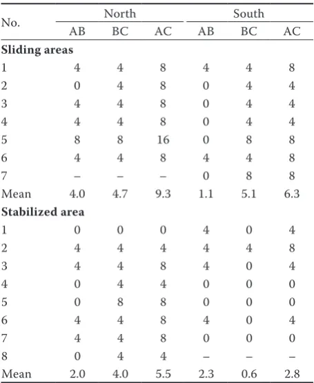
The horizontal movement during the measur-ing periods in slidmeasur-ing areas is presented in Table 1. In north direction, 6 points were marked so that the maximum movement belonged to bench mark 5 (16 cm) and the mean movement of benchmark was 9 cm. This value in south direction in the sec-ond and third sampling was higher than in the first one. The total mean of point movement was 6 cm. The results showed that the movement in north di-rection is 32% higher than in south didi-rection.
[image:3.595.65.465.58.349.2]The horizontal movement based on differences in measuring periods in the stabilized area is shown in Table 1. The mean movement of benchmark was 6 cm. Among 7 benchmarks in the southern sta-bilized area, benchmark 2 showed the maximum movement (8 cm). The mean movement of all
Fig. 1. Schematics of the sampling design in stabilized and landslide areas BM1, BM2 – benchmark 1, 2
Table 1. The horizontal movement of points in three periods of benchmarking (cm)
No. AB NorthBC AC AB SouthBC AC Sliding areas
1 4 4 8 4 4 8
2 0 4 8 0 4 4
3 4 4 8 0 4 4
4 4 4 8 0 4 4
5 8 8 16 0 8 8
6 4 4 8 4 4 8
7 – – – 0 8 8
Mean 4.0 4.7 9.3 1.1 5.1 6.3
Stabilized area
1 0 0 0 4 0 4
2 4 4 4 4 4 8
3 4 4 8 4 0 4
4 0 4 4 0 0 0
5 0 8 8 0 0 0
6 4 4 8 4 0 4
7 4 4 8 0 0 0
8 0 4 4 – – –
Mean 2.0 4.0 5.5 2.3 0.6 2.8
[image:3.595.304.532.438.716.2]benchmarks was 2 cm. The results indicated that the movement in south direction is 95% less than in north direction. The area, length and width of the case study region have differences that are not effective in outputs. The mean movement in the northern sliding area is 9 cm and in the southern sliding area it is 6 cm. The sliding movement in similar areas in north direction is higher than that in south direction (32%). Hence, the geographical direction is effective in landslide, which is similar to results obtained by Moradi et al. (2007).
The results showed that there was no significant difference in the amount of movement between south and north for the sliding area at a 95% confi-dence level, while a significant difference was found for the stabilized area (Table 2).
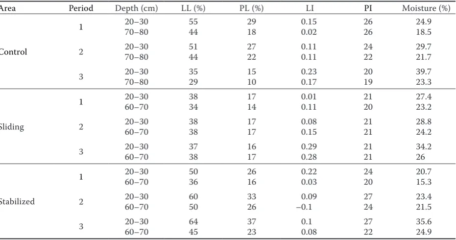
The features of soil mechanics and its texture and grading in north direction are presented in Tables 3 and 4. The results indicated that soil moisture in-creased with the increasing depth. The soil texture in control, stabilized and sliding areas is clay with high liquid limit (CH), CH and clay with low liq-uid limit (CL), respectively. North direction due to its higher moisture has a higher volume of clay
minerals, which is consistent with results obtained by Pourghasemi et al. (2007) and Hosseini et al. (2011). In addition, the movement of benchmarks between the second and third sampling is higher than in the other samplings due to the rainfall in the months of November and March. Although both south and north directions were covered by alder for biological stabilization, alder was more af-fected by south direction. It can be so because this is a light-demanding species which is more
success-Table 4. The characteristics of soil grading and texture in north direction
Area Depth (cm) particles (%)Small particles (%) TextureLarge
Control 20–3070–80 98.178.8 21.21.9 CHCH
Sliding 20–3060–70 85.784.0 14.316.0 CLCL
Stabilized 20–3060–70 98.096.0 2.04.0 CHCH
[image:4.595.61.532.73.113.2]CH – clay with high liquid limit, CL – clay with low liquid limit
Table 3. The characteristics of soil mechanics in north direction
Area Period Depth (cm) LL (%) PL (%) LI PI Moisture (%)
Control
1 20–3070–80 5544 2918 0.150.02 2626 24.918.5
2 20–3070–80 5144 2722 0.110.11 2422 29.721.7
3 20–3070–80 3529 1510 0.230.17 2019 39.723.3
Sliding
1 20–3060–70 3834 1714 0.010.11 2120 27.423.2
2 20–3060–70 3838 1717 0.080.15 2121 28.824.2
3 20–3060–70 3738 1617 0.290.28 2121 34.226
Stabilized
1 20–3060–70 5036 2616 0.220.03 2420 20.715.3
2 20–3060–70 6050 3326 –0.10.09 2724 23.421.5
3 20–3060–70 6445 3723 0.10.08 2722 35.624.9
[image:4.595.306.531.337.442.2]LL – liquid limit, PL – plastic limit, LI – liquid index, PI – plastic index
Table 2. Comparison of the movement in sliding and stabilized areas according to the t-test
Variable Mean SD t-Value df Significance
Movement in sliding area (cm) 14.83 8.83 1.68 11 0.12
Movement in stabilized area (cm) 22.92 2.15 10 13 0.00
[image:4.595.66.532.498.743.2]ful in the southern areas. There is a difference be-tween control and stabilized areas bebe-tween south and north directions. In addition, the southern sta-bilized area has more moisture than the northern stabilized area because alder is a light-demanding species (Marvie Mohadjer 2006).
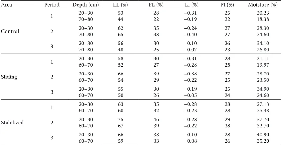
The results of soil mechanics in south direction showed that moisture increased with the increas-ing depth (Table 5). Besides, the soil gradincreas-ing and texture analyses indicated that the soil texture in three control, sliding and stabilized areas (treat-ments) is CH (Table 6). The small particle percent in the studied soil is high. Small particles absorb a large amount of water and reach a higher volume which will be significantly reduced in the course of drying. The high quantity of small particles has adverse impacts on the road in a long time. It in-creases the soil volume and compaction and de-creases the pores which will be more vulnerable to vehicles. This finding is similar to that of Feiznia et al. (2001) and Coe et al. (2003). The liquid index and plastic index and soil moisture have proved the reasons of soil movement and changes from plas-tic to liquid phase. The analyses of soil mechanics show that soil moisture decreased with the increas-ing depth. This value in the control area documents that surface soil has clay with high liquid limit (LL) and deep soil has clay with low plastic limit (PL). Hence, the LL and PL have higher values on the surface, and also the moisture increased from first to third sampling.
CONCLUSIONS
[image:5.595.62.542.73.316.2]The measurements of mean horizontal move-ment in stabilized area, sliding area and control area have been carried out in northern and south-ern aspects. When the alder trees grow in the slid-ing area, they tend to prevent the landslide due to the wide ground coverage of their crowns and root depth. They create a dense land cover and a network of root systems that significantly reduce the landslide movement. 35 years after natural es-tablishment, soil mechanics changed from CL to CH. Since the efficient and practical researches in forests especially forest engineering have a large range, doing such researches needs more atten-tion and consideraatten-tion. The sliding value in north direction of forests in the north of Iran is higher than that in south direction. Hence planning and Table 6. The features of soil grading and texture in south direction
Area Depth (cm) particles (%)Small particles (%) TextureLarge
Control 20–3070–80 97.698.4 2.41.6 CHCH
Sliding 20–3060–70 86.395.9 13.74.1 CHCH
Stabilized 20–3060–70 96.398.2 3.71.8 CHCH
[image:5.595.304.532.389.491.2]CH – clay with high liquid limit
Table 5. The characteristics of soil mechanics in south direction
Area Period Depth (cm) LL (%) PL (%) LI (%) PI (%) Moisture (%)
Control
1 20–3070–80 5344 2822 –0.31–0.19 2522 20.2318.38
2 20–3070–80 6265 3538 –0.24–0.40 2727 28.3024.60
3 20–3070–80 5648 3025 0.100.07 2623 34.1026.80
Sliding
1 20–3060–70 5852 3027 –0.31–0.28 2825 21.1119.97
2 20–3060–70 6654 3929 –0.38–0.22 2725 28.7023.50
3 20–3060–70 5550 3026 –0.050.19 2524 34.9024.60
Stabilized
1 20–3060–70 6360 3532 –0.28–0.23 2828 27.1325.38
2 20–3060–70 7567 4639 –0.28–0.22 2928 37.7032.70
3 20–3060–70 6659 3833 0.100.08 2826 40.9035.20
constructing the forest roads need more attention technically. Bioengineering is a reasonable and economic way to decrease the cost of road main-tenance and ensure the appropriate characteristics of roads based on a close-to-nature approach. Due to its use of local materials, bioengineering is one of the most appropriate methods for reinforcing the slope regions as protection from erosion.
References
Abdi E., Majnounian B., Genet M., Rahimi H. (2010): Quanti-fying the effects of root reinforcement of Persian Ironwood (Parrotia persica) on slope stability; a case study: Hillslope of Hyrcanian forests, northern Iran. Ecological Engineer-ing, 36: 1409–1416.
Abedi T., Hosseini S.A., Naghdi R. (2010): Study of landslides and relation with mechanical soil properties around the forest roads (case study: ChafRood Forest). Journal of Watershed Management, 1: 17–29. (in Persian)
Ahmadi H., Talebi-Esfandarani A. (2002): Study of effective factors on mass movements (landslide) (case study: Ar-dal Region of Chaharmahale Bakhtiari Province). Iranian Journal of Natural Resources, 54: 323–329. (in Persian) Allison C., Sidle R.C., Tait D. (2004): Application of decision
analysis to forest road deactivation in unstable terrain. Environmental Management, 33: 173–185.
Ashish Kumar S. (2010): Bioengineering techniques of slope stabilization and landslide mitigation. Disaster Prevention and Management, 19: 384–397.
Coe J.A., Ellis W.L., Godt J.W., Savage W.Z., Savage J.E., Michael J.A., Kibler J.D., Powers P.S., Lidke D.J., De-bray S. (2003): Seasonal movement of the Slumgullion landslide determined from Global Positioning System surveys and field instrumentation. Engineering Geol-ogy, 68: 67–101.
de Brito Galvão T., Rodrigues Pereira A., Parizzi M.G., Alves da Silva H. (2010): Bioengineering techniques associated with soil nailing applied to slope stabilization and erosion control. Natural Hazards Review, 11: 43–48.
Eker R., Aydin A. (2014): Assessment of forest road conditions in terms of landslide susceptibility: A case study in Yığılca Forest Directorate (Turkey). Turkish Journal of Agriculture and Forestry, 38: 281–290.
Feiznia S., Ahmadi H., Hasanzadeh Nafuti M. (2001): Land-slide hazard zonation in Shalmanrood basin in Gilan prov-ince. Iranian Journal of Natural Resources, 54: 207–219. (in Persian)
Hasmadi M.I., Kamaruzaman J., Azizon J.M. (2008): Forest road assessment in Ulu Muda Forest Reserve, Kedah, Ma-laysia. Modern Applied Science, 2: 100–108.
Hosseini S.A., Lotfi R., Lotfalian M., Kavian A., Parsakhoo A. (2011): The effect of terrain factors on landslide features
along forest road. African Journal of Biotechnology, 10: 14108–14115.
Indraratna B., Fatahi B., Khabbaz H. (2006): Numerical analy-sis of matric suction effects of tree roots. Geotechnical Engineering, 159: 77–90.
Lako A., Marko O. (2012): The impacts of soils erosion caused by forest harvesting and the construction of forest roads. International Journal of Forest, Soil and Erosion, 2: 85–88.
Leung F.T.Y., Yan W.M., Hau B.C.H., Tham L.G. (2015): Root systems of native shrubs and trees in Hong Kong and their effects on enhancing slope stability. Catena, 125: 102–110.
Lewis L., Hagen S., Salisbury S. (2001): Soil Bioengineer-ing for Upland Slope Stabilization. Research Project WA-RD 491.1. Seattle, Washington State Transportation Center: 85.
Maleki S., Naghdi R., Abdi E., Nikooy M. (2014): Investigating the amount of reinforcement of Alnus subcordata root in order to use in bioengineering. Iranian Journal of Forest, 6: 49–58. (in Persian)
Marvie Mohadjer M.R. (2006): Silviculture. Tehran, Univer-sity of Tehran Press: 387. (in Persian)
Moradi H., Davoodi M., Pourghasemi H. (2007): Using GIS in erosion and its application in identifying landslides. In: Sadeghi S.M. (ed.): The Symposium of Watershed and Water and Soil Resources, Kerman, Sept 1–2, 2007: 488–492. (in Persian)
Nazari S., Hosseini S.A., Lotfalian M., Pourmajidian M. (2011): Assessment of soil stability and rupture in forest roads. International Journal of Natural and Engineering Sciences, 5: 55–57.
Operstein V., Frydman S. (2000): The influence of vegetation on soil strength. Ground Improvement, 4: 81–89. Pollen N. (2007): Temporal and spatial variability in root
reinforcement of streambanks: Accounting for soil shear strength and moisture. Catena, 69: 197–205.
Pourghasemi H., Moradi H., Mohammadi M. (2007): Zoning the landslide using statistical methods in Safarood basin. In: Sadeghi S.M. (ed.): The Symposium of Watershed and Water and Soil Resources, Kerman, Sept 1–2, 2007: 174–179. (in Persian)
Preti F., Dani A., Laio, F. (2010): Root profile assessment by means of hydrological, pedological and above-ground vegetation information for bio-engineering purposes. Ecological Engineering, 36: 305–316.
Rees S.W., Ali N. (2012): Tree induced soil suction and slope stability. Geomechanics and Geoengineering, 7: 103–113. Reubens B., Poesen J., Danjon F., Geudens G., Muys B. (2007):
The role of fine and coarse roots in shallow slope stabil-ity and soil erosion control with a focus on root system architecture: A review. Trees, 21: 385–402.
(2012): Relationship of Beserah soil on physical and mois-ture prone to erosion in tropical logged-forest. International Journal of Forest, Soil and Erosion, 2: 63–70.
Schmidt K.M., Roering J.J., Stock J.D., Dietrich W.E., Mont-gomery D.R., Schaub T. (2001): The variability of root cohe-sion as an influence on shallow landslide susceptibility in the Oregon Coast Range. Canadian Geotechnical Journal, 38: 995–1024.
Stokes A., Atger C., Bengough A.G., Fourcaud T., Sidle R.C. (2009): Desirable plant root traits for protecting natural
and engineered slopes against landslides. Plant and Soil, 324: 1–30.
Voottipruex P., Bergado D.T., Mairaeng W., Chucheepsakul S., Modmoltin C. (2008): Soil reinforcement with combina-tion roots system: A case study of Vetiver grass and Acacia mangium Wild. International Association of Lowland Technology, 10: 56–67.