Paleoseismology along the Cittanova fault:
Implications for seismotectonics and earthquake
recurrence in Calabria (southern Italy)
Paolo Galli and Vittorio Bosi
Seismic Survey of Italy, Rome, Italy
Received 12 September 2000; revised 21 September 2001; accepted 3 October 2001; published 7 March 2002. [1] This paper focuses on the seismogenic structure responsible for the 5 February 1783
earthquake (M> 7, Calabria, southern Italy), in particular the slip rate and recurrence time along the Cittanova fault, thus giving new insights on the seismic hazards and seismotectonics of the region. The 1783 earthquake, one of the strongest earthquake of the Mediterranean area, caused more than 30,000 casualties and radically changed the physiography of the local landscape. Until now, the Cittanova fault (or Aspromonte fault) has been generally identified as the surficial expression of the seismogenetic structure, even though its youthful activity has never been demonstrated. Recently, the shortage of geologic evidence of middle-upper Pleistocene activity on this fault led some authors to locate the 1783 fault elsewhere. In our study we used a multidisciplinary approach (paleoseismology, geomorphology, historical seismology, archaeoseismology); our analysis of contemporary literary sources strengthened our interpretation of the coseismic origin of many geological features and, sometimes, oriented our field research toward specific areas. In particular, we excavated trenches and pits at three different sites along the trace of the Cittanova fault for paleoseismological analysis and14C dating. Our data document the Holocene and present activity of the Cittanova fault, providing a minimum vertical slip rate of 0.44 mm/yr and a possible return time of 1350 – 1800 years for earthquakes similar to 1783. The penultimate event has been dated to the 4th century A.D., a time when southern Calabria and eastern Sicily were devastated by an earthquake documented by archaeoseismic analyses. INDEXTERMS:7221 Seismology: Paleoseismology; 7223 Seismology: Seismic hazard assessment and prediction; 7230 Seismology: Seismicity and seismotectonics; 8107 Tectonophysics: Continental neotectonics; KEYWORDS: Paleoseismology, seismotectonics, seismic hazard, southern Apennines, historical seismicity, archaeoseismology
..interroger les faits; c’est le plus bel e´loge qu’on puisse faire de l’e´tude de tectonique se´ismologique: les the´ories passent, les observations restent. Count de Montessus de Ballore [fromHobbs, 1907]
1.
Introduction
[2] At 1245 LT on 5 February 1783 a catastrophic earthquake
struck southern Calabria, Italy, ravaging tens of villages, causing more than 30,000 casualties and radically changing the physi-ography of the local landscape, owing to hundreds of landslides, liquefaction, subsidence, and surface faulting effects. More than 200 lakes formed due to landslides; a tsunami (wave caused by an aftershock-induced landslide) killed a thousand people during the night along shore at Scilla (just northeast of the Messina Strait). The physical effects induced by this earthquake are far and away the strongest and the most extensive among those in
Italy during the past millennium. Intensity 10 MCS (Mercalli,
Cancani, Sieberg scale) was estimated for 48 villages in the Gioia Tauro Plain area, whereas the intensity reached 11 MCS
for half of them [Boschi et al., 1995]. Many villages were
completely devastated; some were never reconstructed and others were rebuilt elsewhere (e.g., Oppido, Santa Cristina d’Aspromonte, Molochiello, Terranova, Polistena, Cosoleto,
Seminara; see below for location). The estimated Richter
mag-nitude of this earthquake is 7 [Working Group Catalogo
Parametrico Terremoti Italiani (CPTI), 1999]. The main event of 5 February was followed by other strong earthquakes in the night and during the following day. At 1310 LT on 7 February another catastrophic event tore through the Mesima Valley (Figure 1), northward to Gioia Tauro Plain (Io = 10.5 MCS,
M = 6.7) followed by hundreds of aftershocks and by another
strong event on 28 March, farther northward, in the Catanzaro
Straits (Io = 11 MCS, M = 7). On the whole, this seismic
sequence lasted until at least 1791. Although the official death toll is cited as just over 32,000, the real toll may have been twice that (18,000 of which later died of epidemics that were
directly attributable to the quakes [Grimaldi, 1784;De Stefano,
1987]). Most of the direct casualties were children and women that remained trapped in their shattered houses, the men being at work in the fields during afternoon of the main shock. Despite the rescue operations and subsequent reconstruction projects enacted by the Bourbon government, the grande flagello (great disaster as termed by the 18th century authors) prostrated and conditioned the economy and development of the region, per-haps until the 20th century.
[3] As for the source of the 5 February earthquake, the
Cittanova fault (CF, or Aspromonte fault) had been generally identified as the surficial expression of the seismogenetic struc-ture. The shortage of geological proof concerning middle-upper Pleistocene activity of the CF led some authors to question its present activity and to search for an alternate seismic source
Copyright 2002 by the American Geophysical Union. 0148-0227/02/2001JB000234$09.00
elsewhere. The questionable nature of the CF and the ambiguity of the alternative sources yielded vastly different characteriza-tions of the seismogenic source and consequently uncertainties in seismic hazard evaluations.
[4] The historical, geological, and paleoseismological data
presented in this paper unravel the uncertainties about the Holocene and present activity of the CF, give a better constraint to the slip rate of the structure, and contribute to a reevaluation of the seismotectonics and seismic hazards definition of the region. Our study of the 1783 surface rupture has been achieved by means of a detailed aerial photographic study of the region (1:33,000 and, locally, 1:20,000 scale) which has been followed by field survey and by the excavation of three trenches and several pits. The systematic reanalysis of the available contem-porary earthquake sources, some of them unknown in the scientific literature, strengthened our interpretation of the coseis-mic origin of many geological features investigated on the field and, sometimes, has addressed the research in specific areas. Finally, we carried out archaeoseismological investigations with the Archaeological Superintendency of Reggio Calabria in order to ascertain if any seismic events similar to the 1783 ones had left traces in the archaeological sites of southern Calabria.
2.
Structural Setting of Southern Calabria
[5] Calabria rests in the tip of the Italian ‘‘boot’’, with Sicily
to the southwest. The Apennines, which extend down the Italian peninsula, are a thrust belt formed above a west dipping subduction zone that retreated eastward during the last 30 Myr [Gueguen et al., 1997], the Calabrian arc being the most arcuate southern part the orogen. The convex sectors of the Apennine arc are those where the subduction hinge rolled back the most, and thus Calabria traveled eastward farther and at fasted rates
(3 – 4 cm/yr [Doglioni, 1991]). In particular, the Calabrian arc
lies above a NW dipping subduction zone (Figure 2) that extends at least 450 km into the asthenosphere, and which is
well characterized by a Benioff plane [Amato et al., 1993]. The
evolution of the arc produced a zone of crustal disequilibrium at the boundary between the uplifting Aspromonte-Serre mountain
chain (25- to 45-km-thick continental crust [Ghisetti and
Vez-zani, 1982]; see Figure 1 for location) and the subsiding
Tyrrhenian basin (only 10-km-thick crust of suboceanic
compo-sition [Finetti and Morelli, 1973]), causing extensional faulting
in the imbricate systems of the thrust belt since lower Pliocene time. The geodynamic evolution during upper Pliocene-Pleisto-cene time caused differential uplifting between the Apennine chain and the Tyrrhenian basin. As a result, a series of elongate N-S and NE-SW trending basins formed on the inner margin of the belt (Crati Valley, Gioia Tauro, Sant’Eufemia, and Messina Strait basins), bordered by important west dipping high-angle normal faults along the Tyrrhenian west coast of southern Italy. The strong uplift of the Aspromonte mountain belt is well evidenced by elevated marine terraces all along the Tyrrhenian coast of Calabria; in particular, the Gioia Tauro area has a succession of 12 Pleistocene marine terraces at vastly different
elevations [Miyauchi et al., 1994]. Lower Pleistocene terraces
have risen 1100 m above see level at a general rate of >0.6 mm/yr. The uplift rate, which varied from 3.8 to 0.3 mm/yr during lower-middle Pleistocene time increased from the upper middle
Pleistocene (300 ka), rising to 0.9 – 1.1 mm/yr [Miyauchi et al.,
1994]. A value of 1.67 mm/yr has been obtained byWestaway
[1993] for middle Pleistocene-Present time.
[6] As mentioned before, the Gioia Tauro Plain is part of a
system of basins that border the Serre-Aspromonte toward the western coast of southern Italy. The Gioia Tauro basin is bordered by well exposed west dipping high-angle normal fault, about 20 km long (Cittanova fault; see Figures 1 and 2c), which separates the mountain range (composed by metamorphic and igneous rocks) from sedimentary marine and continental successions. The basin is filled by 300 – 400 m of upper Pliocene and middle Pleistocene deposits, composed mainly by sandy, marly, and conglomeratic units, unconformably over-laid by 100 m of alluvial fan deposits of middle-upper
Pleistocene [Cotecchia et al., 1986, and references therein;
Tortorici et al., 1995]. The top of the buried crystalline base-ment, from the Tyrrhenian Sea to the Aspromonte range, is gently tilted ESE, as shown by seismic reflection studies [ISMES, 1999], together with the marine sediments which rest Figure 1. Perspective view from NNW of southern Calabria (left) and northeastern Sicily (upper right). The two
basins bounded by the Cittanova and Mesima faults (Gioia Tauro and Mesima basins, respectively) were the epicentral areas of the 5 and 7 February 1783 earthquakes, respectively. A third destructive event on 28 March
occurred farther north, in the Catanzaro Strait. A-A0is the trace of the cross section of the cross section of Figure 2.
Figure 2. (a) Schematic NW-SE section and (b) gravity of the Calabrian Arc (see Figures 1 and 2a for location). The seismicity clearly depicts a Benioff zone offshore of the Calabrian coast, which can be interpreted as the subducting slab of the Ionian lithosphere (seismic data gathered by courtesy of ENEL local network of Gioia Tauro, period 1985 – 1990 and from the NEIS database). (c) A NW-SE schematic geological section of the Gioia Tauro Plain region (area a, pre-Messinian units; area b, Plio-Quaternary units). Note the back tilting of the crystalline basement in the
Gioia Tauro Basin (modified afterFabbri et al.[1980],Cotecchia et al.[1986], andISMES[1999]).
Figure 3. View of the Oppido Sand Formation (middle Pleistocene time according toCotecchia et al.[1986]) close to the Cittanova fault (hanging wall of the Santa Cristina-Molochio strand). The marine succession, which is affected
by ‘‘older’’ normal faulting (white arrows) has been progressively rotated by the Cittanova fault up to 35. Secondary
faults affect the succession (black arrows) parallel to the main strand of the fault, which runs between the marine succession and the crystalline basement (out of photo to right; half man at base for scale, 1 m).
on it in depth. The outcropping Pleistocene units have a
prevalent horizontal bedding, with local tilting of 5– 20
WNW, except near the CF of more than 40 (Figure 3).
3.
Local Seismicity
[7] Southern Calabria is characterized by strong and destructive
earthquakes [Working Group CPTI, 1999]. Along the 180-km
arched belt from the Messina Strait to the Crati Valley, 19
earth-quakes ofM6 occurred since 91 B.C., the most recent one being
the catastrophic 1908Ms= 7.3 Messina earthquake (allMand Io
data derived from Working Group CPTI [1999]; Figure 4).
Although the seismic catalogue covers the past 2 kyr, almost all the recorded events are concentrated in less than three centuries between 1638 and 1908, and they often occurred within a few months or years of one another (e.g., March and June 1638; February – March 1783; 1905 – 1908) or within one century (south-ward migrating sequence of Crati Valley of 1767, 1835, 1854, 1870). However, the strongest events (except those of 1638) occurred in the southern sector, between the Messina and Catanzaro straits (Figure 4). Southern to Catanzaro Strait three moderate
events (Mffi6,Mffi6.5, andMffi5.7, respectively) occurred in
1626, 1659, and 1743 in the area that would be struck in 1783 by destructive earthquakes; in particular, the 1659 event (Figure 5a) occurred between the areas hit by the 7 February and 28 March
1783 events (see Figures 5a – 5f ) as evidenced by its highest intensity data point distribution (HIDD). From the Mesima Valley
(which is also the epicentral area of the M ffi 5.9, 1791 event;
Figure 5g) to the Messina Strait area, apart from the 5 February 1783 and 1894 events (Figures 5a and 5h), only few low intensity earthquakes (Io = 5 – 6 MCS) have been recorded in the past
several centuries. The HIDD of the 1894 event (M ffi 6) shows
that it occurred at the southern border of the destructive area of the 5 February 1783 event. Farther west of the Mesima Valley, the northern sector of Mount Poro block was struck in 1905 by a
Ms= 7.5 event, which is the highest instrumental magnitude ever
estimated in Italy (Figure 5i). The HIDD for this earthquake does not clearly depict any particular trend because of the distribution of the villages and to the nearness of the sea. In 1907 a moderate
event hit the southeastern coast of Calabria (Ms= 5.9; Figure 5j).
The NE-SW trend of its macroseismic field is strongly influenced by the nearness of the sea, whereas the maximum attenuation is probably in the NW-SE direction. In the Messina Strait area,
devastated in 1908 by aMs = 7.3 event (86,000 casualties; note
the NNE-SSW trend of the HIDD in Figure 5k), three
earth-quakes with Io = 9 – 10 (MCS;Mffi6.3) are reported in 91 B.C.,
374 A.D., and 853 A.D. [Working Group CPTI, 1999]. Their real
epicentral location and size are uncertain; the only reliable data are those reported on a memorial stone that mentions damage at Reggio Calabria due to an earthquake that occurred before 374 A.D.
[8] On the basis of the available data it appears that the
seismicity of southern Calabria is mainly expressed by strong clustered (in space and/or time) events that have long return periods (at least more than 1000 years), assuming the completeness of the Italian catalog to be satisfactory at least for the past millennium (for destructive earthquakes). This is particularly true for the area south
of the Catanzaro Straits, where none of theM6.5 earthquakes that
occurred between 1659 and 1908 had precursors in the past millennium. On the contrary, in the Crati basin, where the strongest events are magnitude 6 – 6.5, the return interval seems shorter,
possibly600 – 700 years (a previous Mffi 6 event occurred in
1184 in the Crati basin). Most of the earthquakes mentioned above (see Figure 5) show an elongate NNE-SSW macroseismic trend, whose possible meaning will be discussed later.
[9] The instrumental seismicity of the Gioia Tauro Plain (1980 –
1997, national seismic network of Istituto Nazionale di Geofisica; 1985 – 1990, local network of ENEL, National Electricity
Com-pany) is characterized by sparseM< 4 events, mainly located in the
footwall of the CF (Aspromonte range) and along the NW-SE bounds of the plain (both northern and southern sector). When compared with the neighboring areas, the plain shows a low level of instrumental activity. Events range from 5 to 20 km depth but increase to 60 km in the offshore area of the gulf. Finally, the Tyrrhenian side of the Calabrian arc is affected by well-documented intermediate and deep seismicity, which outlines a probable sub-duction of the Ionian crust beneath the Calabrian arc. Earthquakes as deep as 500 km are recorded in the southern Tyrrenian Sea, deepening from SE to NW. The strongest activity is recorded at
300 km depth, where earthquakes may reach magnitude 7.
[10] The 1783 earthquakes, as mentioned above, were a
cata-strophic and destructive sequence for an area more than 100 km in length (between the straits of Messina and Catanzaro) and 30 km in width (Tyrrhenian coast and front of the Aspromonte-Serre Range; Figure 5k). The rough epicentral locations of the five main shocks are reported in Table 1, together with the MCS intensity and estimated magnitude. Although the damage in the different local-ities for each single event is described by several contemporaneous sources, the intensity of the events that occurred after February 5 are probably affected by uncertainties (i.e., due to cumulative effects). With the exception of 6 February, we observe a migration of the energy release from SW to NE. The HIDD of 5 and 7 February events (Figures 5b and 5c) clearly depict a NE-SW elongated area with intensity decreasing gently toward NW and Figure 4. Shaded relief view of the Calabria region showing
historical events with magnitude5.5 from 217 B.C. to 1992. The
first known event occurred in 91 B.C., the last reported is 1978 (Working Group CPTI[1999] source).
abruptly toward SE (although this image may be artificially sharpened by the absence of villages in the Aspromonte-Serre Range). As for the 5 February event, the distribution of deaths as
percentage (ranging between 2% and 76% [e.g., Carbone Grio,
1884]) displays this trend in a more detailed way (the intensity data points in the Gioia Tauro Plain are, in fact, all between 10 and 11 MCS; Figure 5). On the other hand, the 28 March event (Figure 5e) hit the central eastern part of the Straits of Catanzaro, affecting the villages on the Ionian hill slope of the Serre Range. The HIDD of this event does not define any specific geometrical feature (a vague
NNW-SSE elongated area is possibly shown by intensity 9.5 – 11 MCS), although the cumulative effects of the previous earthquakes might have strongly influenced the distribution of damage.
4.
Previous Studies of the 1783 Seismogenic
Source
[11] The first descriptions of the surface faulting phenomena
were primarily reported by scientists, travelers and technicians sent by the Bourbon government, and those whom visited the Figure 5. Time sequence showing highest intensity data point distribution (HIDD) for the strongest earthquakes in
southern Calabria during the past four centuries. The MCS interval chosen for each HIDD is shown in brackets. Towns and places in Calabria are shown in top left panel.
area a few days after the 1783 earthquakes or in the following years. Among hundreds of fractures, sinking, and cracks pro-duced by landslides and by shaking phenomena, they independ-ently reported a 25-km-long fracture at the foot of the Aspromonte hill slope, between the villages of Santa Cristina and Cinquefrondi (Figure 6). Their interpretation was obviously cast in the knowledge of that time, but as hereinafter shown, the description of the fracture is an impressive snap-shot of the
surface faulting of the 5 February earthquake.Hobbs1907, [p. 228],
believing that the ‘‘greater number of earthquakes are to be ascribed to movements on planes of dislocation,’’ puts the 1783 earthquake as among those characterized by surface faulting and
interprets some of the fractures described by Sarconi [1784] as
evidence of this process. More recently, two different hypotheses have been proposed by various investigators. According to the first hypothesis the CF is responsible for the 1783 earthquake,
whereas according to the second the active seismogenetic struc-ture is a blind fault along the Gioia Tauro Plain coast. In
particular, Cotecchia et al. [1969, 1986] were the first to
explicitly hypothesize that the scarp at the foot of the Aspro-monte range is related to the seismogenetic fault of the 1783
earthquake and interpreted the historical descriptions [e.g., De
Dolomieu, 1784] as ‘‘reactivation’’ of the CF. Cotecchia et al. reported ‘‘fault surfaces’’ on the metamorphic basement between the Sinopoli-Cosoleto-Delianuova and Aspromonte horsts with
oblique, left-hand striae. Cotecchia et al. 1969, [p. 245] also
showed the ‘‘vertical tectonic contact between the Pleistocene sands and the crystalline rocks’’ near the destroyed village of Santa Cristina. A detailed map of the geomorphic changes
triggered by the earthquake [Cotecchia et al., 1986] highlights
the trend of the seismogenetic structure as a continuous line
between Santa Cristina and Cittanova.Tortorici et al.1995, [p. 43]
Table 1. List of the Five Most Severe Events of the 1783 Earthquake Sequencea
Month Day Latitude deg Longitude, deg Io(MCS) Me Ms
Feb. 5 38.30 15.97 11.0 6.88 7.1 Feb. 6 38.22 15.63 8.5 6.34 5.8 Feb. 7 38.58 16.20 10.5 6.56 6.8 March 1 38.77 16.30 9.0 5.85 6.0 March 28 38.78 16.47 11.0 6.98 6.6 a
Io is the Mercalli Cancani Sieberg epicentral intensity.Meis the ‘‘equivalent magnitude’’ evaluated byWorking Group CPTI[1999] on the basis of the areal distribution of the intensities.Msis the magnitude evaluated using Io (Ms= 0.56Io + 0.94 [Working Group CPTI,1999]).
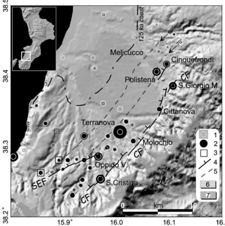
Figure 6. Shaded relief image of the Gioia Tauro Plain (sunlight from NW). Symbols are 1, intensity data point of the 5 February 1783 event (7 – 11 MCS interval); 2, percentage of deaths for the same event (10% minimum to 75% maximum); 3, intensity data points of the 1894 event (8 – 9 MCS interval); 4, trace of the Cittanova fault (CF) and
northern sector of Sant’Eufemia fault (SEF); 5, surficial projection at 10 km depth of the CF (dip 60and 70); 6,
also considered the CF responsible for the 5 February earthquake and mapped it as a continuous line between Delianuova and Cittanova; they also mentioned warping of ‘‘the youngest
sedi-ments of the Gioia Tauro basin’’ along the CF. Tortorici et al.
[1995] gave a minimum uplift rate of the Aspromonte block of 0.6 – 0.7 mm/yr during the last 1.8 Myr (uplift since the upper Pliocene-lower Pleistocene as measured between the highest planation surface on the uplifted block and the inferred thickness of the marine sequence in the Gioia Tauro Basin). On the basis of
the morphological features along the CF scarp, Tortorici et al.
[1995] inferred ‘‘very recent activity’’ of the fault. Considering the height of the triangular facets and the age of the climatic
cycles during which the facets presumably formed,Tortorici et al.
[1995] estimated a vertical slip of 0.8 – 1 mm/yr for the past 240
kyr and 0.7 mm/yr for the past 120 kyr. Westaway [1993]
assumed that the CF was the source of the 1783 event and attributed a footwall vertical slip rate of >0.2 mm/yr to it for the past 0.9 Myr.
[12] On the other hand, Ricchetti and Ricchetti[1991] stated
that there are not stratigraphic and/or structural data that confirm the activity of the CF after early Pleistocene time. In agreement
with Ricchetti and Ricchetti [1991], Valensise and D’Addezio
[1994, p. 10] doubt the presence of ‘‘clearly displaced strati-graphical levels’’ across the CF and concluded that the CF is either the fossil trace of an inactive fault or ‘‘simply an ancient
coast line.’’ Valensise and D’Addezio [1994] assumed that the
fault controlling the geometry and the seismicity of the Gioia Tauro Plain is instead a blind, low-angle, east dipping fault
(Gioia Tauro Fault [Valensise et al., 1993, p. 18]), whose direct
surface evidence is ‘‘evidence of a negative type.’’ Miyauchi et
al. [1994] studied the geochronology of 12 Pleistocene marine
terraces of the area, attributing an age of 1.0 – 1.2 Ma to the highest terrace (I), 950 ka to terrace IV, 300 – 400 ka to terrace VII, 120 ka to terrace X and a generic ‘‘last glacial’’ period to the lower fluvial terrace (VI) close to the Aspromonte foothill.
Miyauchi et al. [1994] also sustained that there is no geo-morphological evidence of active normal faulting after the middle Pleistocene. They mapped the CF as a continuous line
and highlighted the displacement of terrace I (100 m) in the
Piani d’Aspromonte area, across the southern continuation of the CF. Finally, it is worth a note that the official Italian
cartogra-phers [Cassa per il Mezzogiorno (CASMEZ), 1967] do not
show the CF trace at all.
5.
The 5 February 1783 Surface Ruptures
Through the Eyes of the Contemporary Witnesses
[13] For a few days after the first event, the area rocked by
the 1783 earthquakes was a place of a ‘‘pilgrimage’’ by tens of technicians, medical doctors, scientists, and officers that on behalf of F. Pignatelli (General Vicar for Calabria) or driven by personal reasons, wrote letters, reports, and treatises on the causes effects of the earthquake (see also Appendix A). Almost all the writers were struck by the impressive changes to the landscape, mainly caused by landslides and liquefaction
phe-nomena [Cotecchia et al., 1986; Galli, 2000], and by the
hundreds of fractures on the ground surface. However, as mentioned above, some of them described a set of cracks that caught their attention due to the length, continuity, geometry, and orientation. In light of our present knowledge, these cracks represent the surficial expression of the seismogenic fault and generally fit with the tectonic setting of the area. The surficial breaks were drawn by P. Schiantarelli (a member of the scientific expedition sent by F. Pignatelli and headed by M. Sarconi) and represent a precious ‘‘snapshot’’ of earthquake induced effects (see Figures 7 and 8). Particularly, for the Cittanova area, P. Schiantarelli produced a detailed drawing of the Mercante Road where it was cut by the CF (Figure 7a). The etching represents two of the several en echelon steps of the
rupture described bySarconi[1784]. Sarconi depicted the rupture
starting, reaching a maximum amplitude, and diminishing, only to start again and repeat the pattern several times. Sarconi’s descrip-tions of the different morphologies of fault offset were, on the
other hand, the probable source for the work ofBeudant[1821],
who produced a clear sketch of these features (Figure 7b). Historical accounts about features are too numerous for the text, but are instead summarized in Appendix A. It includes the main and most conclusive sentences of authors that observed the surficial breaks, which deal with the general description and specific items devoted to the 5 February event. Text in quotes is a quasi-literal translation from the ‘‘heavy’’ 18th century Italian, with our comments shown in brackets.
6.
Paleoseismological Evidence Along the
Cittanova Fault
[14] The Cittanova fault has been primarily investigated by
means of aerial photo analyses (scale 1:33,000 – 1:20,000) and Figure 7. (a) Details from an original drawing of P. Schiantarelli
(a member of the expedition headed by M. Sarconi). The print shows the displacement of the Cittanova plain and of the Mercante Road due to the 5 February earthquake. Two en echelon steps are visible, the lower being measured by two members of the Bourbon expedition. The upper step is locally affected by landsliding, as shown in the middle of the print. The ‘‘Cavallica’’ Hill is on the left side of the print. We excavated trenches across the fault scarp shown on the left side of the picture. This print is probably the first in the history of earthquake geology to show surface faulting (vertical scale exaggerated). (b) The different expressions of
surface faulting near Cittanova according toSarconi[1784] (sketch
then mapped at 1:25,000 and, locally, 1:10,000 scale. The CF was then surveyed in the field from the abandoned village of Santa Cristina to Santa Giorgio Morgeto, along 20 km of lushly forested hill slope. The CF trace is generally a west facing scarp at the foot of the 500- to 600-m-high western Aspromonte hill slope, at elevations between 270 m and 550 m (Figure 8). In the field the fault appears
both as a single10-m-high scarp or as smaller multiple scarplets,
with a 1- to 3-m-high frontal scarp that, in some place, has a free
face [Wallace, 1977] carved in the cataclastic rocks (granite-derived
sands). The scarp intersects recent alluvial deposits, crystalline basement, and Quaternary sediments. It is composed of a dozen
en echelon strands, 1 – 3 km long which strike N40E, with the
exception of two N25E relay ramps between Cittanova and Santa
Giorgio Morgeto. Almost all the strands show a right step with
respect to the northern ones. The total length of the CF is23 km,
but it is 26 km if we include two other strands which are parallel to the main fault toward the sea. These strands are the northern part of the Sant’Eufemia fault (south to the abandoned village of Oppido) and a strand near Polistena, which probably belongs to the transfer zone between the Gioia Tauro and the Mesima basins (Figure 8). As mentioned above, the footwall of the CF is mainly crystalline basement rock (Paleozoic quartz-monzonite and granite), which always shows a thick cataclastic zone where the granite is reduced to a sandy-silty massive deposit. Structural analyses along the CF
zone showed the main presence of N30– N60E planes, dipping
65– 80NW. A few striae pitch between 90and 60 and show
normal slip with a subordinate sinistral motion. As one approaches the CF, the regressive-marine and continental Pleistocene sequence (hanging wall side), which fills the Gioia Tauro basin and gently
dips toward the sea, is progressively warped in to vertical attitudes near the fault plane. We excavated several trenches and pits at three
different sites along the CF, where we also collected samples for14C
dating (Figure 8 and Table 2). 6.1. Site 1 (Cittanova Village)
[15] We found the first favorable site for paleoseismic analysis
in the village of Cittanova (site 1, Figure 8), where 1950s aerial photos showed a scarp at the base of the hill slope and a truncated alluvial terrace of the Serra River, which borders Cittanova to the south. The choose of this site was also supported by the 1783 historical accounts and by the print by P. Schiantarelli (Figure 7a), which we precisely relocated in the present settlement. Here the fault scarp is 10 m high and cuts both the Serra River terrace and the surface of a small alluvial fan that interfingers with the same
terrace. Although the front of the fault scarp (1.5 km long on the
aerial images) has been completely modified by man’s activities and the upper part of the hanging wall has been completely reworked or removed, we excavate a trench in a small original outcrop that has been partly preserved between two houses and a road (trench 1). In order to reconstruct the geometry and age of the faulted deposits, we excavated other pits in the footwall (pit 1) and hanging wall sides (pits 2 and 3), digging between houses, roads and pipelines. Figure 9 is a sketch of trench 1 and shows the CF when displaces alluvial and colluvial deposits. In the footwall side, well-bedded sand and subrounded to angular gravel outcrop (units 16 – 11) and are overlaid by alternating brown-reddish colluvia (units 10 – 4) and gravelly sands (unit 9). The sand and gravel (units 16 – 9) are the upper part of the above mentioned alluvial fan Figure 8. Perspective shaded relief view of the Gioia Tauro – Aspromonte area. The Cittanova fault runs at the foot
of the Aspromonte Range, between the villages of Santa Cristina d’Aspromonte and San Giorgio Morgeto (elevation in m above sea level). Symbols are 1, location of trenching sites (trench 1, Cittanova; trench 2, Molochio Forest; trench 3, Melone Torrent); 2, location of aqueducts possibly displaced by the 1783 faulting and for which the historical account has been verified on the field (right Polistena, left Santa Cristina).
Table 2. Laboratory and Calibrated Radiocarbon Ages of Samples From Trenches 1 – 3a
Sample Analysis Dated Material Measured Age, years B.P. Conventional Age, years B.P. Calibrated Age
Interceptb Range 1s Range 2s
CN4 R, BLC organic silt 10,880 ± 70 10,890 ± 70 10,985 B.C. 10,770 – 10,715 B.C. 10,785 – 10,700 B.C. CN5 R, BLC organic silt 7,740 ± 70 7,730 ± 70 6515 B.C. 6635 – 6465 B.C. 6,675 – 6,440 B.C. CN6 R, BLC organic silt 12,430 ± 250 12,450 ± 250 12,410 B.C. 13,590 – 12,155 B.C. 13,770 – 11,875 B.C.
CALCN1 R organic silt 24,470 ± 170 24,470 ± 170 . . . .
CALCN2 R organic silt 25,240 ± 540 25,240 ± 540 . . . .
MOL2 AMC organic silt 12,750 ± 40 12,770 ± 40 13,460 B.C. 13,655 – 12,515 B.C. 13,685 – 12,475 B.C. MEL1 R, BLC organic silt 5,330 ± 60 5,360 ± 60 4225 B.C. 4305 – 4060 B.C. 4,355 – 4005 B.C.
MEL2c P silt
MEL3 R, BLC organic silt 1,890 ± 60 1,900 ± 60 95 A.D. 55 – 155 A.D. 30 B.C. to 245 A.D. MEL4 R, BLC organic silt 730 ± 60 730 ± 60 1280 A.D. 1255 – 1295 A.D. 1,205 – 1390 A.D. MELC1 AMS charcoal 1,720 ± 40 1,720 ± 40 340 A.D. 255 – 390 A.D. 235 – 415 A.D.
MOL3 AMS charcoal 33,580 ± 190 33,580 ± 190 . . . .
a
R, radiometric standard analysis; BLC, bulk low carbon; P, pretreatment; AMS, accelerator mass spectrometry. bIntercept of radiocarbon age with calibration curve.
c
for which we obtained14C dates of25 kyr (see Figure 10). The age of the colluvia (units 4 – 8) ranges between 24 kyr and at least 12 kyr (the top of the unit is truncated by erosion; see Figure 10). The hanging wall side is instead represented by a massive reddish colluvium (units 1 and 3), whose parent material is the alternating brown-reddish colluvium outcropping in the footwall. In contrast to the footwall colluvium this one is poorly sorted, less dense, and
slightly finer; a thin stone line highlights a 40back tilting of the
succession with respect to the primary stratification. Rotated pebbles are found, together with lenses of silty materials (unit 17), all along the fault plane. A brownish organic level (unit 2), whose base is also tilted against the fault, may be interpreted as one of the
colluvial wedges related to the retreat of a paleoscarp. Its14C age
of 10,770 – 10,715 BC (1scalibrated age) could provide a rough
estimate for the timing of the paleoevent produced by the CF. However, the event could be much more recent, since units 1 – 3 are derived directly from the dismantling of units 4 – 8, and thus
the date is strongly affected by the 14C/13C ratio of these older
units (‘‘matrix effect’’ (D. Hood, Beta Analytic, personal commu-nication, 2000)). Figure 10 is a geological section across the CF deriving from a temporary excavation carried out for the con-struction of a house. It contains the projected (and horizontally flipped) image of trench 1, which is located 10 m northward from the section. The top of the alluvial body (unit 5 in Figure 10) is interfingered with the bottom of reddish colluvium (unit 3 – 3a), and has a well-constrained age of 25,240 ± 540 and 24,470 ± 170 years B.P. (samples CN1 and CN2, Table 2). These dates are in
agreement with the age assumed byMiyauchi et al.[1994] for the
lower fluvial terrace close to the Aspromonte foothill. Figure 10 also contains the data gathered in pits 1 – 3. In particular, pit 3
exposed the upper part of the reddish colluvium of the hanging wall side (unit 3, dated at 12,450 ± 250 years B.P., 13,590 – 12,155 B.C.) and an overlaying blackish-brownish silt (unit 1, whose lower part was dated at 7730 ± 70 years B.P., 6635 – 6465 B.C.), which was not deposited (or has been eroded) in the footwall side. Pit 2 showed a reddish, massive silty colluvium, similar to units 1 – 3 of trench 1.
6.2. Site 2 (Molochio Forest)
[16] A second site was selected near Molochio, in the forest
of Aspromonte. We dug a trench (site 2 in Figure 8; see also Figure 11) perpendicular to the contact between the crystalline basement and the slope/scarp-derived deposits, along a small
gorge that obliquely crosses a 5-m-high fault scarp. A main
N60E fault plane (dipping 60 NW) cuts white cataclastic
granite (unit 6) and brownish sandy colluvia. The colluvia of unit 3 are stretched and warped along the fault plane, and many clasts are rotated and trapped along the plane. An indurated argillic layer is sandwiched between unit 3 and 6 and contains dip-slip striae (‘‘shear zone’’ in Figure 11). In the hanging wall side a number of antithetic faults affect the slope-derived deposits (units 1 – 5). Units 2 and 3 in the small ‘‘graben’’ feature are strongly disturbed and dragged by the main fault. A piece of charcoal contained in unit 5 (reddish colluvium)
provided a 14C age of 33,580 ± 190 years B.P. (Figure 11).
The upper part of the faulted sequence, up the ground surface, is extensively penetrated and disturbed by roots and pedogenic processes, which have obliterated sedimentary and tectonic features. Few meters away, the uppermost deposit affected by the CF (unit 1, reddish sandy colluvium in the hanging wall Figure 9. Sketch of the eastern wall of trench 1, which was excavated across the Cittanova fault scarp in the village
of Cittanova. A large part of the hanging wall side has been removed and reworked in the 1970s for houses and road building. Level 6 was sampled few meters away (see Figure 10, level 3a).
side, which corresponds to the highest hill slope deposit below the present forest soil also in the footwall side) is well exposed,
and provided a 14C age of 12,770 ± 40 years B.P. (13,655 –
12,515 B.C.; sample MOL2). This date is similar to the one from the top of the succession of the reddish colluvia in Cittanova (top of unit 2, pit 3 of Figure 10).
6.3. Site 3 (Melone Torrent)
[17] The third site was located in the forest between
Citta-nova and Molochio (site 3, Figure 8). We excavated a trench across the contact between the monzonite basement rock and slope-derived colluvia as well as a pit inside the hanging wall deposits (Figures 12 and 13). The footwall consists of highly tectonized monzonite that, approaching the fault zone, passes into a ‘‘gravelly sandy-silty’’ massive unit where it is difficult to recognize the original texture and fabric of the rock. We focused our analyses on the hanging wall where antithetic and secondary
faults affect the scarp/slope-derived deposits. These deposits are composed of granitic sands and silts and by several generations of thin-layered horizons of brownish and reddish colluvia. Figure 13 shows our sketch of the trench. The main footwall side (left side) was not mapped because it is entirely composed of monzonite and cataclastic rocks (unit 13). The entire fault zone is a dozen meters wide, and its most interesting area is that which affects the slope deposits (units 1 – 12). The lower units (11 and 12) are mainly composed of loose to massive granite-derived breccia overlain by angular gravels, with boulders of fractured granite, as well as unit 8. Units 7 – 9 are sandy-silty colluvial deposits, well layered and strongly affected by faulting
and warping. The upper part of unit 7 provided a 14C date of
4305 – 4060 B.C. (Table 2, MEL1; unit 9 could not be dated because of its low carbon content). Units 9 – 7 groups the previous units (to the right from fault at E), which are impossible to define individually because of the strong defor-mation history. Unit 10 is a chaotic mass of sands, fine gravels, and silt layers, with sparse clasts. Units 10 – 6 are clearly separated from the upper horizons (units 5 – 1) by an erosion surface at the base of unit 5. Unit 5, a brownish organic silt with abundant charcoals, has a prominent wedge shape and has been dated at 255 – 390 A.D. (MELC1, Table 2). It contains sparse clasts and is topped by a stone line. Unit 4 is a homogeneous reddish colluvial deposit with brownish silty layers (e.g., unit 3, reworked from older soils upslope; 55 – 155 A.D.; MEL3 in Table 2). We have found unit 4 only in the hanging wall of the main fault, mantling the granite scarp and the older scarp-derived colluvia. Unit 2 (bottom inset in Figure 13)
is a dark organic colluvium (14C date of 1255 – 1295 A.D.;
MEL4, Table 2) and, together with unit 4, is mantled by a coarse sandy unit (unit 1), which represents the last depositional phase of the succession. As mentioned before, faults A – F represent secondary synthetic and antithetic strands of the CF (the main strand is located 4 m NW of fault A). Faults D – F displace units 7 – 12 causing a complex tectonic fabric of the succession; the faults affect deposits as young as 4305 – 4060 B.C. (unit 7) and testify to the occurrence of events after this date since they are truncated by the erosional surface (event horizon c). The different offsets and thickness of units 7 and 8 (e.g., fault at D) could be tentatively related to two different faulting events during deposition of units 7 and 8 (event horizon Figure 10. Geological sketch across the Cittanova fault in the village of Cittanova. The top of alluvial unit 5 (24
ka) is displaced11 m by the CF. The projected image of trench 1 is also shown (Figure 9 horizontally flipped),
located a few meters away from this outcrop, and pits 1 – 3.
Figure 11. Sketch of the eastern wall of trench 2, excavated in the Molochio Forest. Faults A – D affect the slope/scarp-derived
deposits (units 1 – 5), whose age has been determined by 14C
datings. Because of the difficulty of reaching this site with the excavator, the trench was dug by hands. The thick forest coverage and root system have not allowed us to study the upper part of the slope deposits.
c – d). Unit 5 is probably a thin colluvial wedge downward fault B deposited slightly after an offset event (255 – 390 A.D.; event horizon b). Units 2 – 5 have been then displaced by another event that occurred on faults A – C after 1255 – 1295 A.D. (bottom inset in Figure 13; event horizon a), whose colluvium may be unit 1 (possibly derived from the granite free-face scarp caused by the 1783 event, such as that mapped on top inset in Figure 13).
6.4. Abandoned Village of Santa Cristina
[18] The old village of Santa Cristina, which was destroyed
and abandoned after the 1783 earthquake, is currently a thick olive grove and most part of the walls of the destroyed houses have been dismantled, covered, or reutilized as walls within the olive orchard. Nevertheless, the fault scarp formed during the
earthquake [see Coccia, 1783; De Leone, 1783; De Dolomieu,
1784;Caristina, 1786;Vivenzio, 1788;Carbone Grio, 1884] (see
Appendix A) is still visible, and by excavating across this scarp,
we exposed the CF plane (N30E, 80 NW) between the
monzodiorite basement and a clastic continental deposit (well-rounded ‘‘granite’’ cobbles in slightly cemented sand; Figure 14). The latter is affected by other fault planes, along which pebbles are dragged and reoriented; we tentatively relate these sediments
to the upper Pleistocene continental succession (125 ka,
accord-ing toMiyauchi et al.[1994]) which lies in angular unconformity
on the marine Plio-Quaternary succession. The double fault scarp in Figure 14 (total 0.8 m) may represent the 1783 offset. At the bottom of the village, across the continuation of the this scarp, there are three ruined arches of a 17th century aqueduct. The
aqueduct served the mill of the old Santa Cristina and was
‘‘broken’’ by the 1783 earthquake [Coccia, 1783]. Although its
relics have been destroyed by a flood in 1951 (the restored aqueduct was in use until 1950), we found traces of mortar layers
on the rocky face of the CF footwall at an elevation 0.9 m
higher than the top of the arches in the hanging wall side. This value, together with that coming from the scarp in the old village, in lack of data coming from geological exposure, may be tentatively assumed as the local coseismic offset of the 1783 event.
7.
Some Archeoseismic Evidence in the Area
Struck by the 1783 Earthquakes
[19] A crossroad of both people and earthquakes, the
Cala-brian region is rich with stories of cultures accommodating themselves to a violent seismic landscape. Archaeological exca-vations of the past few decades have begun to highlight the complex history of destroyed, rebuilt, or abandoned settlements since the 5th century B.C. Thus, in order to investigate the damaged area of poorly defined or unknown earthquakes during this time, and possibly the twin of the 1783 event, we collected evidence concerning these abrupt phases of abandonment, dis-ruption, reconstruction, and restoration at archaeological sites within the area affected by the 1783 earthquakes (for
methodo-logical issues on archaeoseismology, see Galadini and Galli
[1996, 1999, 2001] and Galli and Galadini [2001]). This goal
has been achieved with the aid of the Archaeological Super-intendency of Reggio Calabria, who made available many Figure 12. Photomosaic of the eastern wall of trench 3, which was excavated near Melone Torrent. Inset shows pit
4, which was dug 25 m away from the trench (see insets in Figure 13), across an antithetic strand of the Cittanova fault (unit numbers are the same as in Figure 13).
unpublished reports concerning archaeological excavations in southern Calabria. Our results are summarized in Figure 15, whereas singular case histories are briefly reported or discussed in Appendix B. On the whole, there is a sparse archaeoseismic evidence concerning possible earthquakes in the 4th and the 1st centuries B.C. (the latter possibly related to an earthquake which hit Rhegion and which was mentioned in a passage of
Strabo [Jones, 1917 – 1928]) and the 1st and 5th to 6th centuries
A.D., but the most convincing indications comes from the 4th century A.D. Surely a strong earthquake hit Rhegion at this time, as mentioned by a memorial stone of Reggio Calabria (see Appendix B). The philological analysis of the Latin text of this memorial stone (E. Andronico, personal communication, 1999) implies that the earthquake, which probably occurred only few years before 374 A.D., was not so catastrophic in Rhegion, since the cause of the collapse of the thermas (baths) are attributed mainly to their old age and second to an earthquake, and only one other restoration is mentioned by the same inscription (to the basilica and not related to the earthquake). In other words, we argue that the event which caused damage to Rhegion was of 8 – 9 MCS rather than an event of 11 MCS, such as the 1908 event, which should have induced the complete disruption of the town. On the other hand, if we put together all the archaeoseismic indications on the 4th century A.D. that comes from sites such as Cinquefrondi, Melicucco, Matauros, Rhegion, Bova Marina, Bianco, Casig-nana, Tyndaris, Patti, and Lipari (Figure 15) and we assume that
they are related to the same event, we have a pattern of damage which is quite similar to that of 5 February 1783 event (on this date, these localities experienced intensities having MCS value of 11 – 7).
8.
Seismotectonics Implications
[20] The geomorphological, archaeoseismical, and
paleoseis-mological analyses carried out along the CF, beside demonstrating the recent activity of the CF itself, yield important data useful in evaluating the possible slip rate of the CF, the timing of its large paleoearthquakes and a possible return time for 1783-like events, in addition to placing some constraints on the behavior of neigh-boring faults.
8.1. Slip Rates
[21] In the Cittanova area the measured displacement of the top
of late Pleistocene alluvial fan deposits is 11 m (Figure 10),
which is of the same order of the offset of the coeval alluvial terrace hanging along the right bank of the Serra River. Consid-ering the age of the alluvial fan deposits (top of unit 5 of Figure 10; 24 – 25 kyr), this offset yields an average minimum vertical slip-rate of 0.44 mm/yr.
[22] At the Molochio site (trench 2), although we were not able
to date the late Holocene deposits and to provide a chronology of coseismic events, we estimate a minimum slip rate of 0.4 mm/yr on Figure 13. Sketch of the eastern wall of trench 3, which was excavated near Melone Torrent. Top right inset is a
simplified drawing of the area (not to scale). Bottom right inset is the small pit excavated 25 m away from the trench, across an antithetic strand of the CF.
the basis of the 5-m-high fault scarp affecting the reddish colluvia (dated at 13 kyr) across the fault zone.
[23] According to Westaway [1993], the present regional
uplift rate (>1 mm/yr in the Calabrian arc) should be subdivided between the regional ‘‘isostatic’’ uplift (the abrupt uplifting of
the Calabrian Arc began 700 kyr ago as an isostatic response
to removal of the detached Ionian slab from beneath Calabria) and the local coseismic uplift. In the case of the Gioia Tauro Plain the latter should then be taken over a single fault (CF, 0.44 mm/yr minimum), whereas in the southern part of Aspro-monte it should be taken over multiple parallel faults (e.g., Armo, Delianuova, and Sant’Eufemia faults: 0.67 mm/yr
max-imum [Westaway, 1993]).
8.2. Paleoearthquakes and Return Time
[24] At both the Cittanova (trench 1) and Molochio Forest
(trench 2) sites the geometry and fabric of the deposits affected by faulting indicate repeated movement of the CF during the past 25 kyr and, surely, during Holocene. Historical descriptions,
Schiantarelli’s and Beudant’s prints andGalanti’s [1792]
descrip-tion of the gravels exposed along the free face of the fresh scarp above Cittanova (units 9 – 16 in trench 1) are supportive evidence for the surface rupture during the earthquake of 1783.
[25] At the Melone Torrent site (trench 3) the age and/or
geometry of the deposits affected by faulting allowed us to propose
a number of coseismic events, although they are related to secondary faults with small amount of offset. As shown on Figure 13, stars a – e represents the event horizons hypothesized in this site. Event ‘‘a’’ occurred after 1255 – 1295 A.D. (MEL4, Table 2) and is, obviously, the 5 February 1783 earthquake. Event ‘‘b’’ was inferred by the presence of the small colluvial wedge 5 at the base of the thick colluvium deposited in the hanging wall of CF (unit 4), directly over the erosional surface which truncated the older units. This event occurred immediately before 255 – 390 A.D. (MELC1, Table 2). Event ‘‘c’’ occurred after 4305 – 4060 B.C. but before the formation of the erosional surface (which is older than 255 – 390 A.D.). This event horizon is related to the last motions of fault D – E, which successively ceased their activity. Events ‘‘d’’ and ‘‘e’’ could have occurred during deposition of units 7 and 8, respectively, before 4305 – 4060 B.C. Nevertheless, the thickening of units 7 and 8 across fault D (to which events ‘‘d’’ and ‘‘e’’ are related) could also be due to a possible horizontal
Figure 14. Exposure of the Cittanova fault (solid arrows) between granite (A) and the continental deposits (B) in the old settlement of Santa Cristina. Secondary fault planes (white arrows) affect also the upper Pleistocene continental succession. This fault has a pronounced double scarp (see the ground level profile;
0.8 m), which, according to the historical sources, formed during
the 1783 event.
Figure 15. History of archaeological sites in southern Calabria and eastern Sicily. (a) Shaded bars indicate the documented presence of a settlement (open bars are uncertain data); solid areas are destruction phase; H is highlight the presence of hoards; R are restoration/reconstruction phases. M is the memorial stone of Rhegion. Note the clustering of destruction/restoration and hoards in the later half of the 4th century A.D. (b) Index map of archaeoseismological evidence for the 4th century A.D. event in southern Calabria-eastern Sicily. The dash/dotted line roughly encloses the level 7 – 8 MCS damage area of the 5 February 1783 earthquake.
component of the CF and different thicknesses of units 7 and 8 perpendicular to the trench wall.
[26] In the Cittanova site (trench 1) all the recent deposits of the
hanging wall side have been removed because of the anthropic works. Only the age of an older event has been hypothesized on the
basis of the14C dating of unit 2 (a colluvial wedge? CN4, Table 2:
10,770 – 10,715 B.C.). Paleoearthquakes have been summarized in Table 3.
[27] Taking into account that the minimum slip rate evaluated
for the CF over the last 25 kyr is 0.44 mm/yr and that an average displacement of the CF could be 0.6 – 0.8 m (offset measured at
Santa Cristina, comparable to ‘‘several palms’’ reported byGalanti
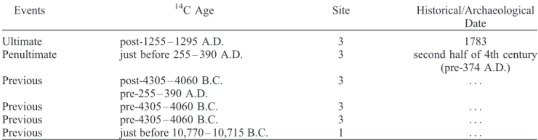
Table 3. Cittanova Fault Paleoearthquakesa
Events 14C Age Site Historical/Archaeological
Date
Ultimate post-1255 – 1295 A.D. 3 1783
Penultimate just before 255 – 390 A.D. 3 second half of 4th century (pre-374 A.D.) Previous post-4305 – 4060 B.C. pre-255 – 390 A.D. 3 . . . Previous pre-4305 – 4060 B.C. 3 . . . Previous pre-4305 – 4060 B.C. 3 . . .
Previous just before 10,770 – 10,715 B.C. 1 . . .
aInvestigated by means of paleoseismic and historical and/or archaeological analyses. The sites are those reported on Figure 8.
Figure 16. Shaded relief map of southern Calabria showing the highest intensity data point distribution of the main events with respect to the known (bold line) and possibly (thin line) active faults of the region. Three focal
mechanisms for the area are shown (1908 and 1975 fromGasparini et al.[1982] and 1978 fromDziewonski et al.
[1989]). Most of the western half of southern Calabria has been affected by earthquakes between 1659 and 1908, causing 150,000 casualties. Today the region in inhabited by more than 1,000,000 people.
[1792], and in agreement with the value related to a surface rupture
length of 23 – 26 km [Wells and Coppersmith, 1994]), the time
interval for earthquakes similar to the 5 February 1783 ranges between 1350 and 2050 years. This implies that a previous event should have occurred between the 3rd century B.C. and the beginning of the 5th century.
[28] As for this event, the penultimate event in trench 3 (event b)
occurred immediately before 255 – 390 A.D. It could be also tentatively related to the earthquake recorded by the memorial stone of Reggio Calabria (occurring few years before 374 A.D.), and with the seismic event of the 4th century A.D., whose archeoseismological indication have been found in several places in southern Calabria and eastern Sicily.
8.3. Relationship With the Neighboring Active Faults
[29] A further relationship between the CF and the 5
Febru-ary 1783 event is provided by the HIDD, which clearly depict the subsurface trend of the seismogenic fault (Figures 6 and 16).
As shown by Galadini et al. [1999] and Galli and Galadini
[1999] for high-angle normal faults in the Apennines, apart from local site-amplification effects, the HIDD lies along an elongated area parallel to the seismogenic fault, above the projection of the fault plane on the surface (that is above its hanging wall side, close to the fault trace). As previously mentioned, in order to obtain a more detailed picture of the 1783 damage distribution we also used data on percentage of deaths reevaluated from original historical sources for each village. This distribution (Figure 6) clearly shows that the highest percentages lie over the projection of the CF at the surface (at 10 km of depth and
with a dip range of 60– 70).
[30] Although we have not yet performed paleoseismic
anal-yses on the other faults of the area, the HIDD of 7 February 1783 (Figure 16) clearly suggest the involvement of the Mesima
fault [Cotecchia et al., 1986; Tortorici et al., 1995] during this
event. From this point of view, the 1659 event, which occurred north of the surface termination of the Mesima fault (see Figures 5a and 16), might be interpreted as the start of the most recent episode of activity on southern Calabria seismogenetic struc-tures, which ruptured progressively until 1908. Conversely, the 1894 event (Figures 5h and 16) might have ruptured the north-ern segment of Sant’Eufemia fault (a barrier?) providing a seismic ‘‘bridge’’ between the 1783 sequence and the 1908 Messina Strait event.
[31] However, the relationship between the 28 March 1783
HIDD (Figures 5e and 16) and the neighboring known faults is
poorly understood.Moretti[2000] tentatively relates this event to
the sinistral strike-slip Lamezia-Catanzaro fault, although the
HIDD is widely scattered. Also the 1905 HIDD (Ms= 7.5; Figures
5j and 16) does not show a clear relationship with known surficial structures. On the basis of the available mapping, we tentatively relate it with the Mount Poro fault system which, according to
Miyauchi et al.[1994], displaces a Pleistocene sequence of marine terraces near the Calabrian coast.
[32] As for the 1908 earthquake, geodetic data analyses suggest
a blind, east dipping low-angle normal fault, located in the Messina
Strait [Capuano et al., 1988; Valensise, 1988]. However, the
geologic evidence of Pleistocene activity of the Calabrian inshore faults (e.g., Armo fault, Reggio Calabria – Sant’Eufemia fault [Ghisetti, 1984, 1992;Tortorici et al., 1995]), some focal
mecha-nisms evaluated byGasparini et al.[1982], and the HIDD for the
event (Figures 5k and 16) all seem to suggest that the fault responsible for the catastrophic 1908 event is a NE-SW west dipping fault, similar to the AF, SEF, and DF of Figure 16. This proposed fault could be related to an antithetic east verging fault in
the strait area, which is a graben-like structure according toGhisetti
[1984]. According to this hypothesis the Messina Strait structure would be the transfer zone between the east facing Malta escarp-ment fault (see Figure 2a for location; this fault is possibly
responsible for the eastern Sicily 1693 event;M = 7.4) and the
NW dipping faults of Calabria.
9.
Conclusions
[33] We applied a multidisciplinary methodology to
individu-ate and characterize the seismogenetic structures of southern Calabria, in particular, those responsible for the devastating 1783 events. The available historical reports concerning the 1783 events provide a precious tool both for evaluating the epicentral areas of the main shocks and recognizing and locating the surficial breaks induced by the earthquakes. Their reanalysis has been particularly important since it allowed us to select some trenching sites.
[34] Our geological and geomorphological surveys permitted
identification and mapping of the main fault strands between the uprising Aspromonte massif and the Gioia Tauro basin, from the villages of Santa Cristina d’Aspromonte to Polistena. The orienta-tion and locaorienta-tion of the Cittanova fault strands fit with the historical description of the main ruptures reported by observers of the 1783 earthquake effects.
[35] Our paleoseismological analyses demonstrate that the
Cittanova fault is active, having produced several Holocene to historical events that were large enough to rupture the surface. In addition, we have demonstrated that this fault was responsible for the 1783 catastrophic earthquake. Radiocarbon dating of samples provided a rough estimate of a 0.44 mm/yr slip rate for the fault during the past 25 kyr and, consequently, for recurrence intervals of 1350 – 2050 years for 1783-like earthquakes. Data from trenches suggest that the time of the penultimate event is 255 – 390 A.D.
[36] Archaeoseismological research performed throughout
southern Calabria has shown that the occurrence of destruction/ reconstruction/abandonment phases cluster in specific intervals since the 4th century B.C. but particularly in the third quarter of the 4th century A.D. The distribution of these archaeoseismic indications fit with the 1783 damage area, and we hypothesize that the earthquake mentioned in the memorial stone found in Rhegion (present Reggio Calabria; dated at 374 A.D.) is the ‘‘penultimate’’ event of the Cittanova fault.
[37] Considering the geological and morphotectonic similarity
between the Cittanova fault and the neighboring Mesima,
Sant’Eufemia, Mount Poro, and Armo faults [see also Ghisetti,
1992; Tortorici et al., 1995], coupled with the intensity data
point distribution of the main earthquakes of the last three centuries (which lie on the hanging wall side of these faults), we argue that the seismogenetic structures responsible for the main destructive seismic energy releases between the Catanzaro and the Messina Straits are those composed by the aforemen-tioned fault system. This system dips mainly toward the Tyr-rhenian basin and may be related to the (continued?) processes of hinge retreat of the subducting Ionian lithosphere and thinning of the Tyrrhenian crust. The Messina Strait structure,
which we consider a graben-like feature [Ghisetti, 1984], may
act as transfer zone between the east facing Malta escarpment (possibly the source of the 1169 and 1693 destructive earth-quakes of eastern Sicily) and the west dipping faults of southern Calabria.
[38] The results obtained have a strong impact on seismic
hazard assessment in the Calabria region (i.e., when using a typical
Poissonian approach [Cornell, 1968]). The slip rate and time
recurrence values that we developed (0.44 mm/yr and 1350 – 1800 years, respectively) are, in fact, considerably different from those existing in the literature for the same fault (i.e., 1 mm/yr and
700 years [Peruzza et al., 1997]), implying a marked reduction in
the local seismic hazard. Moreover, considering the catastrophic spatial cluster responsible for 150,000 casualties between 1659 and 1908, if the entire seismogenic structure of southern Calabria, from
the Catanzaro to the Messina Straits (130 km long), were to rupture again over a time span of 200 – 300 years in the future, this would influence the seismic hazard assessment of a very large region, inhabited now by more than 1,000,000 people. In fact, assuming the estimated time recurrence of 1350 – 2050 years to be reliable for the entire seismogenetic structure, and considering the elapsed time since 1659 (about 350 years), the seismic hazard evaluated by
means of renewal and/or hybrid approaches [i.e.,Wu et al., 1995]
would be dramatically reduced for the next few centuries.
Appendix A:
Anthology of Primary Historical
Sources Concerning Surficial Breaks Caused
by the Earthquake of 5 February 1783
[39] ‘‘. . .almost along all the length of the chain [between the
villages of Cinquefrondi and Santa Cristina] the deposits resting against the granite. . .slipped on this steep slope, and descended a little lower. And then a 9 – 10 miles long rift formed between the sandy and the stiff terrain, and this rift goes continuously from San Giorgio [Morgeto] to Santa Cristina following the bottom of the
foothill. . ..’’ [De Dolomieu, 1784].
[40] ‘‘. . .[Cittanova] whole fields lowered under their primitive
level. . .. All the soil of the plain that surrounds Casalnuovo lowered. . .particularly at the foothill. . .. All the terrain resting on the foothill slipped to a lower position, leaving between the loose and stiff soil open cracks many feet large and 3 – 4 miles long. . .’’ [De Dolomieu, 1784].
[41] ‘‘. . .Cittanova lays on a perfect plain. . .. On this plain big
cracks go from the river [2.8 km to the north] to the torrent [0.5 km to the south], whose waters stopped for many hours during the first earthquake [February 5]. . .the soil, where the house were founded,
was cut by many long rents, 7 – 8 palms large. . .’’ [Vivenzio, 1788].
[42] ‘‘. . .[at Cittanova] big cracks going from the river to the
torrent. As the earthquake occurred the waters of both stopped for many hours. . .the land, where the houses were built, is crossed by
many rents. . .’’ [De Leone, 1783].
[43] ‘‘. . .[at Cittanova] what hit our sight was an horrible crack,
formed along the bottom of the high cliff named Cavallica [Poggio Calcara]. The crack. . .extends toward east, following the bottom of the hill slope, and then turns slightly into the plains, northward. Its length is more than 1000 steps. It is not easy to decide where it started. . .there are. . .several sites where it could start or stop. . .and it is hard to find a unique width along it. There are sites where it is larger than 3 palms [78 cm]: others where it is smaller than half palm [13 cm]; and others where it seems very thin., but further it appears again strong and large. . .. The lowering of the soil. . .often was poor; but elsewhere it was important. Not always the surface of the lowered part was fissured. . .. The typology of the motion was of three orders: lowering of one side, without any changing of the level of the other side;. . .lowering of one portion and raising of the opposite, with warping and folding of the latter. In the third order, all the soil surface was turned upside down, and the upper terrain either remained at the primitive level or it raised. . .’’ [Sarconi, 1784] (but see also Figure 7b).
[44] ‘‘. . .At Casalnuovo [Cittanova] in the hills below the
village we saw a long rent where the ground lowered by several palms, somewhere more and somewhere less, due to the ’83 earthquake. The rent, as they told us, continues until Oppido. The upraised ground seems clean cut and shows. . .a body of
pebbles and gravel deposited by flowing water. . .’’ [Galanti,
1792].
[45] ‘‘. . .In Casalnuovo, where the Quaternary plain joins the
hillslope. . .the ground surface clearly lowered. . .. This depression of the plain necessarily provoked a noticable crack along the cliff contact. The Cavallica hill remained unhurt, but the terrace surface resting on it lowered and wandered away from it, leaving an open
rent more than 1 km long, and variously ondulated. . .’’ [Carbone
Grio, 1884].
[46] ‘‘. . .[Cittanova] in the plain many cracks [‘‘crevasses’’] were
observable, going from the river to the torrent. . .’’ [Caristina, 1786].
[47] ‘‘. . .[Santa Cristina] apart from the lowering of hills
[land-slides], there were huge rents and cracks. . .which I saw. The most impressive rent is located in the upper part [of San Cristina], not far from the huts, two palms large and very long: although its depth has been hidden because of the filling transported by the rain, it is clear that the terrain [the hanging wall] moved away from the firm hill [the footwall]. . .. I let the aqueduct of the mill [the mill was located along the river which runs along the southern hillslope of the old village],
broken by the earthquake, be repaired.’’ [Coccia, 1783]
[48] ‘‘. . .[Santa Cristina] there were great fractures, among
which the important one in the upper part of the city, two palms large and very long: it seemed to us that this fracture could let the
hill falling down toward the lower part of the city. . .’’ [Vivenzio,
1788].
[49] ‘‘. . .[Santa Cristina] there are enormous fissures, among
which the important one that is in the upper part of the ruined city, where recklessness the surviving inhabitants pitched their huts. This fissure is two palms large and so long that it seems to threaten all the area between the fissure and the lower part of the city. . .’’ [De Leone, 1783].
[50] ‘‘. . .[at Santa Cristina] a huge number of fractures and
crevasses crossed the mountain [Aspromonte foothill] in all its
length, and it seems that all the rest could lower. . .’’ [De Dolomieu,
1784].
[51] ‘‘. . .[Santa Cristina] and the city, due to the same shock
[February 5] had a great fissure, very long and two steps large. . .’’ [Caristina, 1786].
[52] ‘‘. . .on the hillslope of Mt. Zerbo` [upward Santa Cristina]
the thick layer of conglomerates and sands, laying on the marls [the Pleistocene sequence]. . .and the broad terrace. . .slipped. . .away from the massive, shaking granite, opening a transversal valley. . ..-.where fell down the sands and the houses of S. Cristina. . .From the hills of San Giorgio Morgeto to those of Molochio. . ..and Cinque-frondi there is a unique large crack [‘‘crevasse’’]. The crystalline rocks was exhumed; the deposits moved away and lowered and between them remained a 25 km long rent. . .not yet filled by debris
an alluvia after 100 years. . .’’ [Carbone Grio, 1884].
[53] For the area of San Giorgio Morgeto,Vivenzio[1788],De
Leone[1783], andCaristina [1786] described a 3- to 4-km-long crack in the areas called Molinello, Giuseppina, and Ruota (actually, near Polistena), and another 1 km long in the land called Gentile (at the foothill of San Giorgio, toward Cittanova).
[54] For the area of Polistena, Vivenzio[1788], De Dolomieu
[1783], and particularlySarconi [1784] described a 5- to
6-km-long rent (partly the same of that in San Giorgio area) starting from the Cappuccini Friars monastery and going toward the hillslope. The rent goes ‘‘from SE to E, and then turns toward NE.’’ The crack from site to site displays an offset of 0.5 – 3 m and sometime forms swells of squeezed soils; it crosses and displaces the
aqueduct in the land of ‘‘Donna Luciani’’ [Sarconi, 1784], and
here this crack seems to join with a perpendicular rent (going toward Cinquefrondi, NE). As for the land of Donna Luciani, Pompeo Schiantarelli produced a drawing showing the rent.
[55] In the Cinquefrondi area, Sarconi [1784] probably
described the same rent coming from Polistena, in the site where ‘‘. . .the public road of Ventriconi horribly divided. . .’’
[56] Finally, in the Oppido area,Carbone Grio[1884] describes
a transversal rent that cuts the Melle highland (Melle was the Roman settlement of Mamertion).
Appendix B:
Archaeoseismological Data
Concerning Southern Calabria
B1. Gioia Tauro Plain
[57] Unfortunately, in the epicentral area of the 5 February