Up to this point we have only had speculative data in connection with the securing (the defensive works) of the eastern side, towards the Danube, of the Roman era Civil Town of Aquincum. However, in connection with the earth moving work related to the reconstruction of the Budapest–Esztergom railway line that began in 2013, there was finally an opportunity to perform research on the eastern edge of the settlement. We were able to identify the long sought after town wall, and we achieved new results in connection with the history of the eastern border of the settlement.
THE EASTERN WALL OF THE CIVIL TOWN: RESEARCH HISTORY
Locating the eastern defensive works of the Civil Town has occupied research on Aquincum for 120 years (Fig. 1). Up until now we have had very little information about the settlement’s northeastern corner, the point where the northern town wall turns to the east. Lajos Nagy hypothesized that the city’s eastern wall was located under the buildings of the gasworks housing estate.1 In 1947 János Szilágyi presumed he had discovered the end of the northern town wall to the north of Pók Street on the axis of Jégtörő Street in the form of a “sally port”, where the wall would have turned to the south.2 Later these hypotheses could neither be disproven nor reinforced, because the precise location of the excavations could not – lacking geodetic surveying – subsequently be identified. Later efforts aimed at locating the town wall were unsuccessful
1 Nagy, Lajos: Topográfia, polgárváros (Topography, Civil Town). In: Budapest története (History of Budapest) I–II., ed.
Alföldi, András – Nagy, Lajos – László, Gyula (Budapest: Királyi Magyar Egyetemi Nyomda, 1942), 366–385.
2 Szilágyi, János: Jelentés a Fővárosi Ókortörténeti (Aquincumi) Múzeum kutatásairól és szerzeményeiről az 1945–48 évek
folyamán / Rapport sur les recherches et les nouvelles acquisitions du Musée Municipal d’Histoire Antique (Aquincum) de 1945 à 1948. Budapest Régiségei 15 (1950), 311, footnote 19.
Fig. 1: The topographical location of the Aquincum settlement (Google Earth, graphics: Krisztián Kolozsvári)
Orsolya Láng • The Eastern Defensive Works of the Civil Town of Aquincum: Answer to an Ages-Old Question
2
HUNGARIAN ARCHAEOLOGY E-JOURNAL • 2014 SPRING
(e.g. Klára Póczy’s excavations on Jégtörő Street, and later investigations utilizing geophysical methods at the same location) (Fig. 2).
The researchers’ explanation for the “missing” eastern town wall – which was correct as we will see later – was because the terrain in the Roman era sloped down from west to east. Therefore, the remains of the town wall were to be found deeper underground and, due to the lack of deep test trenches had yet to be uncovered.3 All that could be presumed was that the border of the city must have run about on the axis of Jégtörő Street, since Lajos Nagy found the remains of dwellings and streets underneath the gasworks housing estate,4 and to the east of that he found a minor temple district that may have indicated the edge of the settlement5 (Fig. 3).
3 Zsidi, Paula: Verkehrsverbindungen, Wehranlagen, Straβennetz. In: Forschungen in Aquincum 1969–2002, hrsg. P. Zsidi (Budapest: Budapesti Történeti Múzeum, 2003), 140; Láng, Orsolya: Feltárások az aquincumi polgárváros keleti határán / Excavations on the eastern edge of the Civil Town of Aquincum. Aquincumi Füzetek 16 (2010), 19.
4 Nagy, Lajos: Topográfia, polgárváros (Topography, Civil Town). In: Budapest története (History of Budapest) I–II., ed.
Alföldi, András – Nagy, Lajos – László, Gyula (Budapest: Királyi Magyar Egyetemi Nyomda, 1942), 376.
5 Póczy, Klára: A termékenység-kultusz terrakottái Aquincumban (Terracotta of the Fertility Cult in Aquincum). Budapest Régiségei 20 (1963), 246; Zsidi, Paula: Aquincum polgárvárosa (Civil Town of Aquincum) (Budapest: Enciklopédia Kiadó, 2002), 68–69.
Fig. 2: Ground plan of the Aquincum Civil Town, with the location of the hypothesized eastern town wall (dashed line) (Aquincum Museum of the Budapest History Museum, drawing archives)
A NEW OPPORTUNITY FOR RESEARCH: THE RENOVATION OF THE BUDAPEST-ESZTERGOM RAILWAY LINE
We were looking forward to the renovation of the railway line that began in 2013, as we considered it a great opportunity for archeological excavations. The line was built along a traditional transportation corridor in the area of the road through the Solymár Valley leading to the bank of the Danube, a route that has purportedly been continuously used since prehistory. In the Roman Period one of the branches of the diagonal road connecting Brigetio (Komárom-Szőny) with Aquincum in a northwest-southeast direction ran here, and after reaching the Civil Town it cut through the town in a west-east direction6 (Fig. 4). The work also promised to be exciting because during the construction of the railway line at the end of the 19th century no systematic investigative work was performed on the area. This most likely can be explained by the fact that the first large scale excavations on the area of the Civil Town had only begun a bit earlier, so the researchers had relatively little information about the civilian or military nature of the settlement or about its extent. According to the inventory books, however, a few objects were placed in the Aquincum Museum (e.g. a bronze statue of a small black boy and architectural terracotta pieces) that suggest that archeological sites may have been disturbed during the construction of the railway line. A portion of the intact objects presumably may have come from the graves of one of the town’s cemeteries, since the railway embankment runs through both the settlement’s eastern cemetery (which is called the “Gasworks [gázgyári] Cemetery” in the professional literature) and the cemetery along the Aranyhegyi Stream located to the west of the city. It was also determined that a fragment of a mosaic floor and an inscribed altar stone were found to the northeast of the city’s forum at the end of the 19th century – presumably also in connection with the construction of the railway. On the basis of these facts, researchers came to the conclusion that a mithraeum
6 Zsidi, Paula: Aquincum polgárvárosa (Civil Town of Aquincum) (Budapest Enciklopédia Kiadó, 2002), 26; Láng, Orsolya:
Az aquincumi polgárváros / The Civil Town of Aquincum. In: Rómaiak a Dunánál. A Ripa Pannonica Magyarországon, mint világörökségi helyszín (Romans at the Danube. The Ripa Pannonica in Hungary as a World Heritage Site), ed. Visy, Zsolt (Pécs: PTE Régészeti Tanszék, 2011), 30.
Fig. 3: Relationship of the Civil Town of Aquincum and the modern city (Aquincum Museum of the Budapest History Museum, drawing archives)
Orsolya Láng • The Eastern Defensive Works of the Civil Town of Aquincum: Answer to an Ages-Old Question
4
HUNGARIAN ARCHAEOLOGY E-JOURNAL • 2014 SPRING
Fig. 4: The relationship of the Civil Town of Aquincum and
the northeast-southwest running (diagonal) road (Aquincum
Museum of the Budapest History Museum, drawing archives)
Fig. 5: Roman era archaeological sites along the line
of the Budapest-Esztergom railway
(drawing: Krisztián Kolozsvári)
– linked to the Victorinus family – may have stood somewhere in this area.7 The precise site of origin of the finds is unknown now, however.
Archaeological investigations have been performed on the Civil Town and its immediate vicinity on numerous occasions in the past 120 years. In the wake of these we now know significantly more about the Roman Period topography in the area along the railway (Fig. 5). The railway line that runs in an east-west direction passes over the Danube on the Northern Railway Connecting Bridge and then arrives at the Roman town’s eastern (Gasworks) cemetery on the bank of the Danube. This cemetery that was in use from the 2nd-4th centuries A.D. is well known and has been continuously researched since the beginning of the 20th century. Just to the west of this there was a large potter’s workshop that was in use in the 2nd century whose northern edge is skimmed by the railway line.8 The line “enters” the northern part of the territory of the former city at the axis of today’s Jégtörő Street and cuts through it for about a half of a kilometer. Past the western town wall it also cuts through a section of the suburbs and skims a minor potter’s workshop that was in use in the last quarter of the 1st century A.D. and the beginning of the 2nd century.9 It also cuts through the western cemetery along the Aranyhegyi Stream that was used in the Early Roman Period (this lies for the most part on the territory of the Óbuda Station).10 From here to the west – to the city limits of the modern capital – the railway runs through the villa district of the Roman settlement, and also for a while presumably runs parallel to the road to Brigetio mentioned above (Fig. 6).
7 Nagy, Lajos: Vallási élet Aquincumban (Religious Life in Aquincum). In: Budapest története (History of Budapest) I–II., ed.
Alföldi, András – Nagy, Lajos – László, Gyula (Budapest Királyi Magyar Egyetemi Nyomda, 1942), 433.
8 Zsidi, Paula: Transformation of the town structure in the civil town of Aquincum during the Severi (A.D. 193–235). Acta Archaeologica Academiae Scientiarum Hungaricae 53 (2002), 139.
9 Póczy, Klára – Zsidi, Paula: Lokales Gewerbe und Handel. In: Forschungen in Aquincum 1969–2002, hrsg: P. Zsidi (Budapest: Budapesti Történeti Múzeum, 2003), 191–192.
10 Lassányi, Gábor: Újabb feltárások az Aranyhegyi-patak menti temetőben / Recent excavations in the cemetery along the
Fig. 6: The section of the railway through the cemetery along the Aranyhegyi Stream and the villa district (photograph: Gábor Rákóczi)
Fig. 8: The line of the eastern town wall of the Civil Town during excavation (photograph: Orsolya Láng)
Fig. 7: The surfaces opened in the railway embankment with the Roman period relics (photograph: CIVERTAN Bt., graphics: Krisztián Kolozsvári)
RESULTS FROM THE RESEARCH PERFORMED IN
2013
The two sections opened on the planned site of the railway bridgeheads on the eastern edge of the city proved to be the most interesting, since these were located right along the path of the presumed eastern town wall (Fig. 7). Roman period phenomena of various types clearly indicated the border of the town. Our analysis was aided by the trial trenches we made in 2009, north of the present area, which showed sections of Roman period ditches.11
Relics discovered in the area opened at the site of the western bridge pillar, were from three construction periods that could be dated to the Roman Period. The earliest phase was indicated by an approximately 3 meters wide ditch with a V-shaped cross section, which ran along the eastern edge of the trench in a north-south direction. This large ditch was at least 1.6 meters deep, calculated from the level on which it was detected. Its continuation had already been identified by the aforementioned research in 2009. A 1.2 meters wide wall ran parallel to the ditch, about one and a half meters from its western edge. The stones of the wall had been removed, with only its rectangular foundation ditch remaining, and this was filled with earth containing pieces of mortar and small stones. We had also documented a detail of this in 2009 (Fig. 8). On the basis of the stratigraphic observations, the wide ditch and the wall may have been from the same period. To the west of the wall there was a line of postholes, which presumably may be the evidence of some structure connected to the wall. On the western edge of the excavation section a dirt road running in a northeast-southwest direction and the drainage ditch accompanying it were discovered.
11 Láng, Orsolya: Feltárások az aquincumi polgárváros keleti határán / Excavations on the eastern edge of the Civil Town of
Orsolya Láng • The Eastern Defensive Works of the Civil Town of Aquincum: Answer to an Ages-Old Question
6
HUNGARIAN ARCHAEOLOGY E-JOURNAL • 2014 SPRING
On the basis of the nature of the objects and their topographical location we can conclude that we have succeeded in laying our hands on the eastern border of the settlement here, with the foundations of the former town wall. A walkway (as indicated by the postholes) may have been attached to the inside of the wall, whose stones were later reused elsewhere, and it was accompanied by a moat on the outside. Our hypotheses are also supported by the results of the 1947 excavations by János Szilágyi mentioned above. The foundation of the eastern wall of the Civil Town discovered now may appear to be narrow, since for example the foundations of the southern town wall were on average 1.5–2.2 meters wide in the section excavated. However, the section of the northern town wall excavated at the gate tower was also only 1.2–1.3 meters wide.12 János Szilágyi measured a width of 1.5–1.7 meters at the northeastern “corner” of the city, where he hypothesized the aforementioned sally port. The upper section of the narrower wall that was uncovered now may even have been a wooden structure, or – interpreting the remaining stump of a wall running parallel to the town wall of which a very short portion was observed at the northern section wall of the trench – we could suppose that they employed further reinforcement at some places. Not only the wall, but also the width of the moat that was documented now is smaller than the sections of the fossa
of the Civil Town’s defensive works excavated so far – those are on average 3.8–5 meters wide.13
The portion of the settlement’s first (dirt) road on the inner side of the wall also belongs to this period. According to the evidence of the Samian ware that came from the clearing of the road, this period can be dated to the first decades of the 2nd century A.D. at the earliest. These are South Gaulish pieces, while Central Gaulish fragments were discovered from the later stratum of the road. On the basis of the sections of town wall discovered so far on the other sides of the city, research places the construction of the walls during the reign of Hadrian, so it can be presumed that the eastern town wall was also erected in this period. The paving of the aforementioned dirt road may have taken place in the next period (the mid – end? of the 2nd century), and from this road stratum came Central Gaulish Samian ware fragments. To the west of the road, buildings with stone foundations were already
being constructed. Following this, the defensive works in this section were removed, the stones were dismantled from the wall and the moat became filled in (or possibly got filled in). Also here there are the walls of a building – of unknown use – that are from this period. These were in the vicinity of the moat, and a portion of them were probably even built atop it. Later the walls were also removed from here. The restoration and processing of the finds are only in their initial stages, but the pieces that have value for dating now indicate that the town wall and its associated moat were no longer in use by the first half of the 3rd century, they were already dismantled or filled in. The datable finds are primarily from the infill layers of the moat – fragments of Rheinzabern and Westerndorf Samian ware, a quite worn Hadrian coin, a worn 2nd century sestertius, a fragment of a
12 Zsidi, Paula: Aquincum polgárvárosának városfala és védművei az újabb kutatások tükrében / Stadtmauer und Verteidigunssystem
der Zivilstadt von Aquincum im Spiegel der neuesten Forschungsergebnisse. Communicationes Archaeologicae Hungariae
(1990), 147–152, 154.
13 Ibid.
Kapitän II type amphora,14 and an intact knee brooch with a semicircular head plate with a single-line zig-zag design.15
Later, the first road inside the town walls was renovated, but the defensive works were never again repaired. The road that was formed from spreading rocky debris on the top of the former moat bears testimony to the final period of the area’s use. A horseshoe, an iron chain and nails from the Middle Ages or the Modern Period were found on its surface. When the 19th century railway embankment was being constructed this road surface and the remains of an earlier Roman wall were on the surface of the ground.
We were only able to observe relatively few Roman period construction phases at the site of the excavation when compared to the other sections of the Civil Town. This can be explained by the fact that the edges of the city were only built up later, so during the nearly four hundred years of Roman settlement less reconstruction and remodeling occurred there (the situation is similar in the southeastern section of the city as well16).
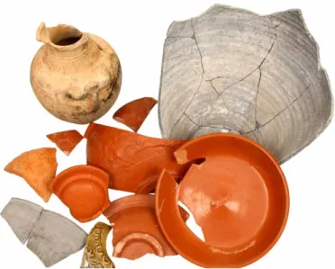
The phenomena uncovered at the site of the eastern bridge pillar clearly indicated a peripheral area outside the city limits. In the northwestern part of the section a large (at least 7×5 meter), square refuse pit was discovered. This pit, which was on average 1 meter deep, held a large number of Roman period finds: many relatively intact vessels (jugs, pots and Samian ware) and animal bones (Fig. 9). The upper layer of its fill was made up of burnt, red debris from kilns and refuse bricks. This in part may have come from the potter’s workshop nearby (known in the literature by the “Gasworks” [gázgyári] name)17 and in part from the lime kilns nearby. The original function of the pit may have been something else – it may have been a semi-subterranean house or even a workshop. This is suggested by some postholes on the edge of the
14 Vámos, Péter – Gabler, Dénes – Hárshegyi, Piroska – Lassányi, Gábor: Eastern Mediterranean import and its influence on
local pottery in Aquincum. Acta Archaeologia Scientiarum Hungaricae 60 (2009), 63.
15 Merczi B/1 version: Merczi, Mónika: Térdfibulák Komárom-Esztergom megyéből (Knee Brooches from Komárom-Esztergom
County). Komárom-Esztergom Megyei Múzeumok Közleményei 17 (2011), 29–31.
16 Láng, Orsolya: Új eredmények az aquincumi polgárváros délkeleti régiójának kutatásában – az úgynevezett Festőház és
közvetlen környezete / New results in research on the southeastern part of the Civil Town in Aquincum – the so-called “Painter’s House” and its surroundings. Aquincumi Füzetek 18 (2012), 21–22.
17 Kuzsinszky, Bálint: A gázgyári római fazekastelep Aquincumban (The Gasworks Roman Potter’s Settlement in Aquincum). Budapest Régiségei 11 (1932), 3–423.
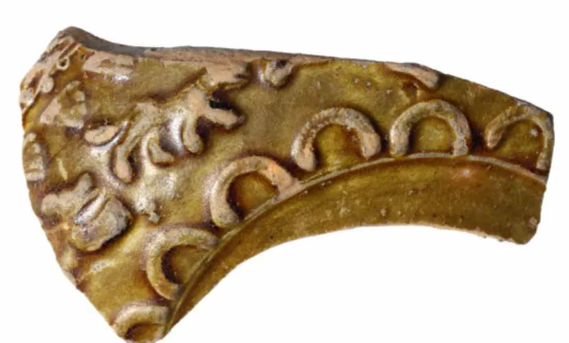
Fig. 10: Fragment of the glazed dish with relief decorations from the refuse pit (photograph: Péter Komjáthy)
Fig. 11: Lead votive object depicting the god Silvanus from the vicinity of the refuse pit (photograph: P. Komjáthy)
Orsolya Láng • The Eastern Defensive Works of the Civil Town of Aquincum: Answer to an Ages-Old Question
8
HUNGARIAN ARCHAEOLOGY E-JOURNAL • 2014 SPRING
structure and by the rocky layer found at the bottom of the trench, although we did not find other evidence suggesting a house (remains of the floor level or a stove).
The restoration and evaluation of the finds is still underway, but the objects that have value for dating already indicate that the pit was in use from the beginning of the 2nd century A.D. to the middle of the 4th century. The lowest levels of fill produced fragments of Samian ware from southern and central Gaul, while from the upper levels of fill in the trench a small bronze coin of Constantine I minted between 335 and 337 was found18 together with a presumably imported dish fragment with green glaze and relief decorations (Fig. 10). Later – but still during the Roman Period – a well was dug into the filled refuse pit. After the well was filled in, partially cremated bodies of animals – small dogs and/or cats – were interred here. This also suggests that the area was on the outskirts of the city. In the vicinity of the trash pit, but in the upper, mixed layer, an intact lead votive object came to light, which depicts a figure in a contrapposto pose standing in an aedicule wearing a short tunic holding a knife with an angled blade (a grapevine pruner?) in its left hand and an unidentifiable object in its right, perhaps a tree branch or piece of fruit. At its right leg sits a four-legged animal, probably a dog. The figure – on the basis of the characteristics of its iconography – may be a depiction of the god Silvanus. The find is yet another relic of what was a quite popular cult in the Civil Town of Aquincum19 (Fig. 11).
The significance of the discoveries in 2013 primarily lies in the fact that we were able to get information about the northern and eastern portions of the Roman settlement and their immediate surroundings. It was shown that the 19th century railway construction fortunately only slightly disturbed the antique relics, and the railway embankment in effect was built upon some wall remains and ground levels that were still visible on the surface here and there at that time. The discovery of the remains of the Civil Town’s eastern defensive works is also a very important new result, as is the fact that we have significantly more data than previously about the use of the eastern outskirts of the city.
RecommendedliteRatuRe Polenz, HaRtmut (hrsg.)
Das Römische Budapest. Münster: Lengerich, 1986. zsidi, Paula (hrsg.)
Forschungen in Aquincum 1969–2002. Budapest: Budapesti Történeti Múzeum, 2003. láng, oRsolya
The Civilian Town of Aquincum. In: Romans on the Danube. The Ripa Pannonica in Hungary as a World Heritage Site, ed. Visy, Zsolt, 29–36. Pécs: PTE Régészeti Tanszék, 2011.
máRity, eRzsébet
Chronological problems and special features in the structure of the civilian city of Aquincum.
Communicationes Archaologicae Hungariae (1992), 65–73.
18 Bruun, P.M.: Roman Imperial Coinage, vol. VII. (London: Spink, 1966), 252.
19 Zsidi, Paula: Bleivotive aus Aquincum. Kölner Jahrbuch 33 (2000), 322–328; Szirmai, Krisztina: Silvanus, Priapus ábrázolások a BTM Aquincumi Múzeumában (Depictions of Silvanus and Priapus at the Aquincum Museum of the Budapest History Museum). Budapest Régiségei 41 (2007), 45.