3.9 BIOLOGICAL
RESOURCES
3.9.1
Introduction to Analysis
This section describes the habitat within the project study and direct impact areas and presents an evaluation of potential impacts to biological resources, including federally-listed threatened and endangered species, other special status species, wildlife, fisheries, vegetation, and noxious weeds for the No Action Alternative and Preferred Alternative. The project study area included lands within 300 feet of the centerline of the alignment and a 300-foot buffer around the station footprints. The direct impact area (DIA) is defined as the area that would be physically disturbed by construction of the alignment and stations.
3.9.1.1 Summary of Results
Large portions of the project study area consist of industrial, residential, or disturbed habitats that have low sensitivity to biological impacts because the species present are adapted to human activities and habitats. The project would have relatively large impacts to grassland habitats, especially in the Northern Section. Riparian woodlands, shrubland, and marsh are considered more sensitive because they are relatively natural, have greater value for wildlife, and occupy only small portions of the North Metro corridor study area. The project would have minor effects on aquatic habitats in Sand Creek, South Platte River, Big Dry Creek, and some small ponds. Black-tailed prairie dog (Cynomys ludovicianus) colonies are present in the Northern Section and would be affected by both the alignment and the stations under the Preferred Alternative. Several raptor nests were observed, which included a great-horned owl nest 500 feet from the Southern Section alignment, and a red-tailed or Swainson’s hawk nest approximately 0.25 mile from the alignment. Along the northern alignment an active bald eagle nest was observed approximately 0.8 mile away from the 144th Avenue Station. Inactive raptor nests were observed near the 88th Avenue Station, 112th Avenue Station, and State Highway 7 (SH 7)/162nd Avenue Station. The project could affect nesting raptors and other migratory birds. Wildlife corridors at Sand Creek and South Platte River are not likely to be adversely affected, but movement along Big Dry Creek could be affected. Construction may cause the spread of noxious weeds but would be minimized with best management practices (BMPs). There would be no effects to federally-listed threatened and endangered species within the project direct impact area. To avoid indirect impacts on downstream federally protected species due to water depletions in the Platte River system, consultation will continue with the USFWS under Section 7 of the Endangered Species Act (ESA). There could be effects to a state-listed species, the burrowing owl (Athene cunicularia), if it is present at prairie dog colonies. There would be minor impacts to some other special status species. Many of these resources are protected by
statutes, executive orders (EOs), and regulations.
The No Action Alternative would primarily affect habitats adjacent to existing roads and railroads and would not fragment undeveloped habitat or wildlife corridors. The wildlife in the North Metro corridor study area are generally adapted to human activities, and the projects associated with the No Action Alternative would cause limited changes beyond loss of habitat. Animals could be disturbed, displaced, or killed during construction. Active bird nests could be lost if vegetation clearing occurs during the nesting season. Noxious weeds could be introduced or increased by movement of construction vehicles and clearing of vegetation.
3.9.1.2 Relevant Law
Laws applicable to biological resources include the National Environmental Policy Act of 1969 (Title 42 United States Code [USC] Sections 4321-4347), the Endangered Species Act (16 USC 1531-1543), the Fish and Wildlife Coordination Act (16 USC 661-667d), the Migratory Bird Treaty Act (MBTA) (16 USC 703-712), Federal EO 13186 – Responsibilities of Federal
Agencies to Protect Migratory Birds, Federal EO 13112 – Invasive Species, Colorado Noxious Weed Management Act (Colorado Revised Statutes 35-5.5-101-119), and the State of Colorado EO D00699 – Development and Implementation of Noxious Weed Management Programs.
3.9.2 Affected
Environment
The North Metro corridor study area is primarily urban in the Southern Section, transitioning to a more suburban and rural character in the Northern Section. Eleven habitats are found
throughout the North Metro corridor study area and project study area (see Table 3.9-1). The definitions and descriptions of these habitat types apply to the North Metro corridor alignment and all of the stations. See Figures 3.9-1 through 3.9-6 for a selection of habitat-type
photographs. As discussed in Table 3.9-1, sensitive habitats and wildlife corridors, which include prairie dog colonies, occur in the project study area and overlap the other habitat types. The project study area includes lands within 300 feet of the centerline of the alignment and a 300-foot buffer around the station footprints.
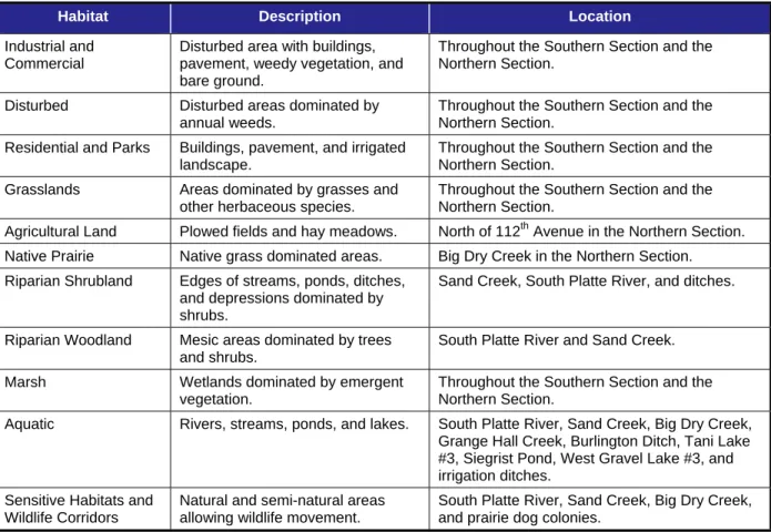
TABLE 3.9-1. HABITATS IN THE NORTH METRO CORRIDOR STUDY AREA
Habitat Description Location
Industrial and Commercial
Disturbed area with buildings, pavement, weedy vegetation, and bare ground.
Throughout the Southern Section and the Northern Section.
Disturbed Disturbed areas dominated by
annual weeds.
Throughout the Southern Section and the Northern Section.
Residential and Parks Buildings, pavement, and irrigated landscape.
Throughout the Southern Section and the Northern Section.
Grasslands Areas dominated by grasses and other herbaceous species.
Throughout the Southern Section and the Northern Section.
Agricultural Land Plowed fields and hay meadows. North of 112th Avenue in the Northern Section. Native Prairie Native grass dominated areas. Big Dry Creek in the Northern Section. Riparian Shrubland Edges of streams, ponds, ditches,
and depressions dominated by shrubs.
Sand Creek, South Platte River, and ditches.
Riparian Woodland Mesic areas dominated by trees and shrubs.
South Platte River and Sand Creek.
Marsh Wetlands dominated by emergent
vegetation.
Throughout the Southern Section and the Northern Section.
Aquatic Rivers, streams, ponds, and lakes. South Platte River, Sand Creek, Big Dry Creek, Grange Hall Creek, Burlington Ditch, Tani Lake #3, Siegrist Pond, West Gravel Lake #3, and irrigation ditches.
Sensitive Habitats and Wildlife Corridors
Natural and semi-natural areas allowing wildlife movement.
South Platte River, Sand Creek, Big Dry Creek, and prairie dog colonies.
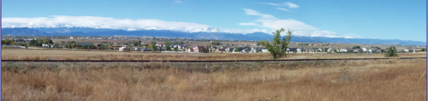
FIGURE 3.9-1. GRASSLANDS HABITAT IN THE PROJECT STUDY AREA
FIGURE 3.9-2. NATIVE PRAIRIE HABITAT IN THE PROJECT STUDY AREA
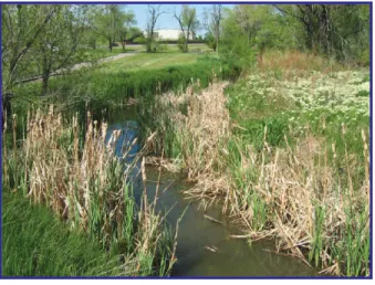
FIGURE 3.9-4. MARSH HABITAT IN THE PROJECT STUDY AREA
FIGURE 3.9-5. DISTURBED HABITAT IN THE PROJECT STUDY AREA
FIGURE 3.9-6. RIPARIAN WOODLAND HABITAT ADJACENT TO RESIDENTIAL AND PARKS IN THE PROJECT STUDY AREA
Several federal and state special status species protected under state or federal laws were observed or could be found in the North Metro corridor study area (see Table 3.9-2). Federally-listed endangered and threatened species are protected under the Endangered Species Act (ESA). The United States Fish and Wildlife Service (USFWS) may list species as endangered, threatened, or proposed. “Endangered” means a species is in danger of extinction throughout all or a significant portion of its range. “Threatened” means a species is likely to become endangered within the foreseeable future. “Proposed” means a species is proposed in the Federal Register to be listed under Section 4 of the ESA. The Colorado Division of Wildlife (CDOW) also maintains a threatened, endangered, and special concern list, which includes all of the federally-listed species plus additional species.
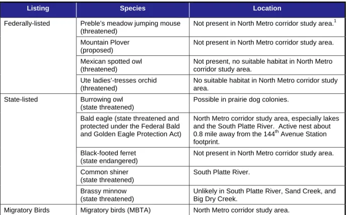
TABLE 3.9-2. POSSIBLE SPECIAL STATUS SPECIES IN THE NORTH METRO CORRIDOR STUDY AREA
Listing Species Location
Federally-listed Preble’s meadow jumping mouse (threatened)
Not present in North Metro corridor study area.1 Mountain Plover
(proposed)
Not present in North Metro corridor study area. Mexican spotted owl
(threatened)
Not present, no suitable habitat in North Metro corridor study area.
Ute ladies’-tresses orchid (threatened)
No suitable habitat in North Metro corridor study area.
State-listed Burrowing owl (state threatened)
Possible in prairie dog colonies. Bald eagle (state threatened and
protected under the Federal Bald and Golden Eagle Protection Act)
North Metro corridor study area, especially lakes and the South Platte River. Active nest about 0.8 mile away from the 144th Avenue Station footprint.
Black-footed ferret (state endangered)
Not present in North Metro corridor study area. Common shiner
(state threatened)
South Platte River. Brassy minnow
(state threatened)
Unlikely in South Platte River, Sand Creek, and Big Dry Creek.
Migratory Birds Migratory birds (MBTA) North Metro corridor study area.
Source: Andrews and Righter, 1992; CDOW, 2010; Kingery, 1998; Fitzgerald, Meaney, and Armstrong, 1994; NDIS, 2006; Hanopy, 2006; North Metro Corridor Project Team, 2009; USFWS, 2010.
Notes: 1
The alignment is within the United States Fish and Wildlife Service Denver block clearance for the Preble’s meadow jumping mouse.
The federally-listed species in this table include all those species that are known to occur or that have historically occurred in Adams and Denver counties, according to the published USFWS county list (USFWS 2010). Additional species that may be affected by water depletions in the South Platte River in downstream reaches in other states are not included in this table and are excluded from further analysis because no alternatives include water depletions.
The state-listed species in this table are a subset of the state threatened and endangered list (CDOW 2010). The literature listed for this table “source” was used to assess which species could occur in the North Metro corridor study area based on habitat requirements and current range.
3.9.2.1 Southern Section — DUS Access to 84th Avenue
Eight habitats are present in the Southern Section (see Table 3.9-1). Wildlife species in the Southern Section are those adapted to urbanized areas of landscaped and disturbed habitat, as well as a variety of different habitats.
A black-tailed prairie dog colony is present in the project study area just north of Interstate 76 (I-76). Prairie dog colonies provide habitat for raptors, burrowing owls, cottontail rabbits, other rodents, amphibians, and reptiles.
The project study area in the Southern Section includes three crossings of the South Platte River where riparian woodland and aquatic habitats represent sensitive habitat and serve as a wildlife corridor.
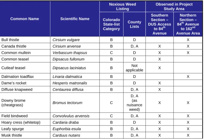
Nineteen species of noxious weeds were observed in the Southern Section during field surveys in 2006 and 2007 (see Table 3.9-3). Noxious weeds are plant species not native to Colorado and that are regulated under state law because they have negative impacts on crops, native plant communities, livestock, and/or the management of natural or agricultural areas. Each county in the project study area also maintains a list of noxious weeds that are a local priority. The most common weeds in the project study area were Canada thistle (widespread in moist areas), downy brome (widespread in disturbed areas), field bindweed (common grassland and disturbed areas), hoary cress, and Scotch thistle (common along the railroad right-of-way [ROW]).
TABLE 3.9-3. NOXIOUS WEEDS KNOWN OR LIKELY TO BE PRESENT IN THE PROJECT STUDY AREA
Common Name Scientific Name
Noxious Weed Listing Observed in Project Study Area Colorado State-list Category County Lists Southern Section – DUS Access to 84th Avenue Northern Section – 84th Avenue to 162nd Avenue Area
Bull thistle Cirsium vulgare B D X
Canada thistle Cirsium arvense B D, A X X
Common mullein Verbascum thapsus C D X X
Common teasel Dipsacus fullonum B D X
Cutleaf teasel Dipsacus laciniatus B Not
applicable X
Dalmation toadflax Linaria dalmatica B D X
Dame’s rocket Hesperis matronalis B D X
Diffuse knapweed Centaurea diffusa B D, A X
Downy brome
(cheatgrass) Bromus tectorum C
D, A (as nuisance
weed)
X X
Field bindweed Convolvulus arvensis C D, A X X
Hoary cress (whitetop) Cardaria draba B D X X
Leafy spurge Euphorbia esula B D, A X X
TABLE 3.9-3. NOXIOUS WEEDS KNOWN OR LIKELY TO BE PRESENT IN THE PROJECT STUDY AREA
Common Name Scientific Name
Noxious Weed Listing Observed in Project Study Area Colorado State-list Category County Lists Southern Section – DUS Access to 84th Avenue Northern Section – 84th Avenue to 162nd Avenue Area
Perennial pepperweed Lepidium latifolium B D X X
Poison hemlock Conium maculatum C D X X
Puncture vine Tribulus terrestris C
D, A (as nuisance
weed)
X
Quackgrass Elymus repens B D X
Redstem filaree Erodium cicutarium B D X X
Russian olive Elaeagnus angustifolia B D X X
Salt cedar, tamarisk Tamarix parviflora,
T. ramosissima B D, A X X
Scotch thistle Onopordum acanthium B D, A X X
Yellow toadflax Linaria vulgaris B D, A X
Source: URS, 2007. Notes:
Colorado state-list categories:
B = State List B species are managed by the State Noxious Weed Management Plan, with the goal of stopping their continued spread.
C = State List C species are those for which the state, in consultation with other parties, will develop management plans with the goal of supporting jurisdictions that choose to require management of those species.
County list categories: A = Adams County D = City and County of Denver
Nuisance weed = Adams County designation — undesirable plants that can become a hazard or nuisance, that can cause injury to animals, the environment, or humans
DUS = Denver Union Station
According to the USFWS, four species are listed as federally threatened or proposed and may occur in Denver and Adams counties, including the Preble’s meadow jumping mouse (Zapus hudsonius preblei), mountain plover (Charadrius montanus), Mexican spotted owl (Strix
occidentalis lucida), and Ute ladies’-tresses orchid (Spiranthes diluvialis) (USFWS 2006, 2010). The only species that is known or likely to occur is the bald eagle, which is no longer federally listed as threatened but is still protected under the Bald and Golden Eagle Protection Act. A summary of the special status species potentially occurring in the North Metro corridor study area is provided in Table 3.9-2.
State-listed threatened and endangered species include the species on the federal list, plus the burrowing owl (Athene cunicularia) and common shiner (Luxilus cornutus). The burrowing owl could occur at the one prairie dog colony (but is generally unlikely to occur in the project study area), and the common shiner may occur in the South Platte River. Other special status
species may occur in the riparian areas along the South Platte River, including bird species during migration, wintering, or foraging. Other special status species include species
considered by CDOW as special concern (CDOW 2010), Partners in Flight watch list species (Rich et al. 2004), species of conservation concern (USFWS 2002), “species of greatest
conservation need” in Colorado’s Comprehensive Wildlife Conservation Strategy (CDOW 2005), and species considered rare or vulnerable by the Colorado Natural Heritage Program. Most bird species are protected from direct mortality and destruction of active nests by the MBTA.
A great-horned owl nest and two Buteo nests (red-tailed hawk or Swainson’s hawk) were observed within approximately 0.25 mile of the alignment. The nests were observed after the breeding season, and active use in 2007 and 2008 was not confirmed. The two hawk nests are probably alternate locations for the same pair. Additionally, red-tailed hawks exhibiting territorial behavior were observed in riparian woodland habitat along the Lower Clear Creek Canal, and the birds may have nested near the alignment in this area. Nest locations are likely to change over time.
3.9.2.2 Northern Section — 84th Avenue to 162nd Avenue Area
Ten habitats are in the Northern Section. In addition to the eight habitats in the Southern
Section, agricultural land and native prairie habitat are present. The wildlife likely to occur in the Northern Section are similar to those described for the Southern Section. However, the only aquatic habitats are Big Dry Creek, ditches, and small ponds; therefore, there is little habitat for waterfowl or shorebirds. Big Dry Creek is approximately 15 feet wide at the alignment crossing and crosses the tracks through a culvert.
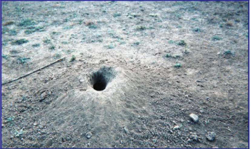
The grasslands, native prairie, and prairie dog colonies (see Figure 3.9-7) present in the
Northern Section are used by foraging raptors such as the red-tailed hawk (Buteo jamaicensis), Swainson’s hawk (Buteo swainsonii), and American kestrel (Falco sparverius). Raptor nests were observed near the 88th Avenue Station, 112th Avenue Station, and SH 7/162nd Avenue Station. The 88th Avenue Station nest appears to be that of a red-tailed hawk, but the species using the other nests were not identified.
FIGURE 3.9-7. PRAIRIE DOG BURROW
A bald eagle winter foraging area is mapped along Dry Creek south of 144th Avenue but outside of the project study area. Bald eagles are highly transient in the winter and can be found
anywhere with a food source in the vicinity, which generally includes fish-bearing bodies of water, carrion (carcasses), waterfowl, and prairie dogs. Bald eagles are commonly observed in the Denver metropolitan area in the winter. An active bald eagle nest is located about 0.8 mile away from the 144th Avenue Station.
Big Dry Creek and its riparian habitat are part of an undeveloped corridor that extends from Standley Lake in Jefferson County to the South Platte River. Prairie dog colonies are present in several locations along the alignment and at proposed stations, including colonies in the
vicinities of 104th Avenue, 112th Avenue, 120th Avenue, 160th Avenue (SH 7), and Big Dry Creek. Most of the 104th Avenue colony is in the City of Thornton’s Grandview Open Space and Prairie Dog Habitat. Prairie dog colonies provide habitat for several species, including wintering raptors.
Sixteen species of noxious weeds have been observed in the Northern Section of the project study area (see Table 3.9-3).
The potential for federally-listed threatened and endangered species to occur in the Northern Section is the same as described for the Southern Section. The burrowing owl, a state-listed species, could occur in prairie dog colonies. Other special status species, as described for the Southern Section, could occur, especially along Big Dry Creek.
3.9.3 Impact
Evaluation
3.9.3.1 Methodology
Impacts were assessed by comparing the project activities and facilities within the DIA to the biological resources described in Section 3.9.2, Affected Environment, for each of the
alternatives and project components. Acres of habitat loss were assessed using geographic information system overlays. Impacts are described by timing (construction versus operation), mode of action (direct, indirect, temporary, or cumulative), and duration (short-term versus long-term, where long-term means more than 3 years).
3.9.3.2 Results
Table 3.9-4 presents a summary of impacts for the North Metro corridor study area.
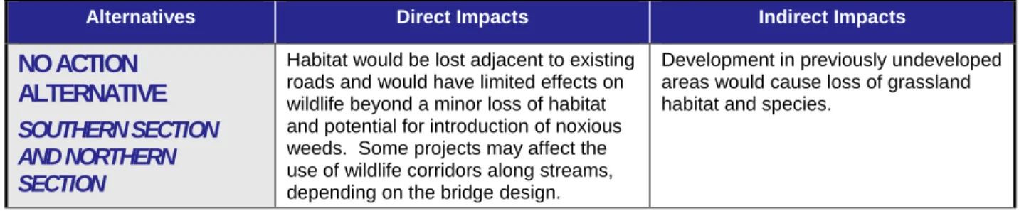
TABLE 3.9-4. DIRECT AND INDIRECT IMPACTS SUMMARY — BIOLOGICAL RESOURCES
Alternatives Direct Impacts Indirect Impacts
NO ACTION
ALTERNATIVE
SOUTHERN SECTION AND NORTHERN SECTION
Habitat would be lost adjacent to existing roads and would have limited effects on wildlife beyond a minor loss of habitat and potential for introduction of noxious weeds. Some projects may affect the use of wildlife corridors along streams, depending on the bridge design.
Development in previously undeveloped areas would cause loss of grassland habitat and species.
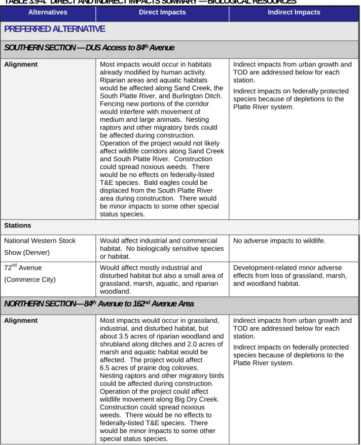
TABLE 3.9-4. DIRECT AND INDIRECT IMPACTS SUMMARY — BIOLOGICAL RESOURCES
Alternatives Direct Impacts Indirect Impacts
PREFERRED ALTERNATIVE
SOUTHERN SECTION — DUS Access to 84th Avenue
Alignment Most impacts would occur in habitats already modified by human activity. Riparian areas and aquatic habitats would be affected along Sand Creek, the South Platte River, and Burlington Ditch. Fencing new portions of the corridor would interfere with movement of medium and large animals. Nesting raptors and other migratory birds could be affected during construction. Operation of the project would not likely affect wildlife corridors along Sand Creek and South Platte River. Construction could spread noxious weeds. There would be no effects on federally-listed T&E species. Bald eagles could be displaced from the South Platte River area during construction. There would be minor impacts to some other special status species.
Indirect impacts from urban growth and TOD are addressed below for each station.
Indirect impacts on federally protected species because of depletions to the Platte River system.
Stations
National Western Stock Show (Denver)
Would affect industrial and commercial habitat. No biologically sensitive species or habitat.
No adverse impacts to wildlife.
72nd Avenue (Commerce City)
Would affect mostly industrial and disturbed habitat but also a small area of grassland, marsh, aquatic, and riparian woodland.
Development-related minor adverse effects from loss of grassland, marsh, and woodland habitat.
NORTHERN SECTION— 84th Avenue to 162nd Avenue Area
Alignment Most impacts would occur in grassland, industrial, and disturbed habitat, but about 3.5 acres of riparian woodland and shrubland along ditches and 2.0 acres of marsh and aquatic habitat would be affected. The project would affect 6.5 acres of prairie dog colonies. Nesting raptors and other migratory birds could be affected during construction. Operation of the project could affect wildlife movement along Big Dry Creek. Construction could spread noxious weeds. There would be no effects to federally-listed T&E species. There would be minor impacts to some other special status species.
Indirect impacts from urban growth and TOD are addressed below for each station.
Indirect impacts on federally protected species because of depletions to the Platte River system.
TABLE 3.9-4. DIRECT AND INDIRECT IMPACTS SUMMARY — BIOLOGICAL RESOURCES
Alternatives Direct Impacts Indirect Impacts
Stations
88th Avenue (Thornton) Would mostly affect industrial and grassland habitat, and nearby raptor nest in addition to 0.5 acre of riparian
woodlands.
Development-related, likely to eliminate grassland habitat, and may affect riparian woodland habitat. 104th Avenue (Thornton) Would primarily affect industrial and
grassland habitat, but would eliminate 0.3 acre of marsh, riparian shrub, and aquatic habitat.
Development-related, likely to reduce grassland and prairie dog habitat. Prairie dog colony extends off-site, and much of it would continue to be protected in open space. 112th Avenue (Northglenn) Would mostly affect grassland, industrial,
and residential habitat, including 1.0 acre of prairie dog colonies.
Development-related, likely to reduce or eliminate grassland and prairie dog habitat. Could also affect riparian shrubland and marsh along ditches. 124th Avenue/Eastlake
(Thornton)
Would mostly affect agricultural (hay meadow), some industrial, and grassland habitats as well as 0.4 acre of riparian woodland.
Induced growth and TOD could reduce grassland and isolated groves of trees.
144th Avenue (Thornton) Habitats that would be affected are disturbed, grasslands, agricultural, and industrial. No sensitive biological resources.
No adverse effects to wildlife.
SH 7/162nd Avenue (Thornton)
Would affect mostly disturbed, industrial, grassland, and agricultural habitat, plus a small area of riparian woodland with a raptor nest.
All existing habitats would likely be reduced from development, including prairie dog habitat. Loss of open habitats and prairie dogs would affect a variety of species, including raptors. The most important habitat (along Big Dry Creek) is likely to be protected as open space, which would conserve the use as a movement corridor, but disturbance from adjacent development could have minor adverse impacts on wildlife use.
Source: North Metro Corridor Project Team, 2010. Notes:
Data presented for the alternative include mainline rail impacts only and not station impacts. DUS = Denver Union Station
SH 7 = State Highway 7
T&E = threatened and endangered TOD = transit oriented development
No Action Alternative Direct Impacts
The projects included as part of the No Action Alternative primarily consist of improvements to existing roads, including road widening, intersection improvements, and bridge replacements. They also include several Regional Transportation District (RTD) FasTracks projects that generally follow existing railroad alignments and some projects (such as changes in signals)
that would have no biological impacts. Development would also continue throughout the North Metro corridor study area.
Direct impacts to vegetation and habitat would primarily occur from vegetation clearing and earthmoving. The projects would mostly affect the common urban habitats that occur next to roads, including industrial and residential in developed areas, grasslands, and disturbed areas. Small areas of riparian woodland and shrubland may be affected, and prairie dog colonies adjacent to existing roads would also be affected. Much of the impact would be permanent, with former habitats replaced by pavement or other facilities. Nearly all of the impacts would occur in habitats that have already been strongly modified by past human activities and which are
common in the project study area and not considered sensitive.
In general, the wildlife species in the project study area are adapted to human activities and habitat features, and the projects associated with the No Action Alternative would cause limited changes beyond loss of habitat. Animals may be disturbed or displaced during construction, and some may be killed during construction. Active bird nests could be lost if vegetation clearing occurs during the nesting season. Measures taken by project proponents to comply with the MBTA would reduce, but not eliminate, this potential.
The projects could introduce new noxious weeds or increase the abundance of existing weeds, from movement of construction vehicles and clearing of vegetation. The projects would be unlikely to have adverse effects on federally- or state-listed threatened and endangered species.
Indirect Impacts
Although North Metro would not be implemented, development of station sites along the other FasTracks lines within the corridor study area would result in increased urban densities caused by transit oriented development (TOD). The majority of the indirect impact would be within 0.5 mile of the station platforms. The change from lower density to higher density around these station sites would reduce the amount of open and vacant land. However, most stations are proposed in developed areas, and would have little impact to high-quality biological habitat. Positive impacts could result from increased density with less demand for development of greenfield areas at lower densities.
Temporary Construction Impacts
Temporary impacts to vegetation and habitat include removal or physical disturbance of existing vegetation in areas adjacent to permanent facilities. These areas would typically be reseeded after construction.
Impacts to wildlife during construction include disturbance and displacement, temporary habitat fragmentation, and effects on movement due to construction noise and activity. Wildlife would lose habitat adjacent to the construction areas due to disturbance. Less-mobile and burrowing animals could be buried during earthwork and clearing. Temporary effects on wildlife would typically be minor because the project study area is located along existing roads. Temporary effects on aquatic habitats could also occur from erosion and sedimentation, and especially from in-stream construction at water crossings. Noxious weeds could be introduced in disturbed areas but would be minimized with BMPs.
Cumulative Impacts
Land use changes in the Denver metropolitan area between 1950 and 1990, including large increases in developed land, caused the loss of about half of the grassland habitat present in 1950 (RTD 2007). Other changes included an approximate 33 percent decrease in wetlands and an increase in open water. The loss of grassland habitat (mostly hay meadow and pasture) reduced the diversity and abundance of species adapted to rural environments and may have increased the presence of species adapted to urban environments. A number of species are adapted to both rural and urban environments, and these species may not have been
substantially affected by the change. The amount of woody vegetation did not change substantially between 1950 and 1990, and wooded riparian areas continue to provide movement corridors and habitat for migratory birds. However, riparian areas have suffered encroachment and loss of habitat quality by invasive plants.
Development is expected to continue under the No Action Alternative and would cause
continued reduction in grassland and agricultural habitats. This would decrease or eliminate the populations of species that require grassland habitat and increase those adapted to urban habitat. Pond and riparian habitat loss would likely be less than other habitat types because these areas are more likely to be protected in parks and open space corridors and would continue to provide an important source of biodiversity in a largely urban area.
No historic data on areas occupied by prairie dogs are available, but prairie dog colonies are likely to have been limited in extent in 1950. Prairie dogs typically reach their largest
populations in areas where agricultural practices are abandoned prior to development and are subsequently reduced or eliminated when development occurs. It is likely that most of the prairie dog colonies on private lands would be eliminated in the future and that prairie dogs would survive in the project study area only in specific areas designated for their protection.
Preferred Alternative Direct Impacts
Southern Section — DUS Access to 84th Avenue
Vegetation, Habitats, and Wildlife
Direct impacts to vegetation and habitat would primarily occur from vegetation clearing and earthmoving. Most of the affected habitat would be permanently replaced by the track, station facilities, and roadway and trail improvements. These impacts represent the maximum area of disturbance. Portions of the direct impact area would be revegetated after construction.
Revegetation would typically consist of seeding with grasses to stabilize the soil, but shrubs and trees may be used in riparian areas. Most of the area of direct permanent effect would occur in habitats that have already been heavily modified by human activity.
The only prairie dog colony observed within the Southern Section project study area would not be affected by either the alignment or the stations. The Preferred Alternative would cross Sand Creek on the east side of Burlington Ditch, where it would affect riparian woodland and
shrubland.
Other habitats are considered to have a moderate sensitivity to disturbance. The grassland habitat affected includes portions of large, undeveloped areas north of the South Platte River at 78th Avenue, as well as areas near Sand Creek, Riverside Cemetery, and areas adjacent to highways. Approximately 3.6 acres of impacts to aquatic and riparian habitats would be
affected. Impacts would include bridge construction over Sand Creek and three locations on the South Platte River, as well as the Burlington Ditch.
The proposed track alignment would be adjacent to existing track for much of the Southern Section and would not cause a new division of previously contiguous habitat in these areas. More frequent traffic along the tracks would discourage wildlife movements across the tracks during operational hours, but this is likely to be a minor effect. The Preferred Alternative between 54th Avenue and 71st Avenue would not follow existing track but would be located in urban habitats where the track would have minimal effects on wildlife movements.
Wall structures can prevent wildlife movement, but these structures would be located in areas where they are unlikely to affect movement. Currently, there are some sections of the alignment that are not fenced. Security fencing would be installed along these sections and would
interfere with movement of medium to large animals. Fencing would not be installed under bridges, however. Therefore, fencing would have no effects on the most important movement corridors.
A great-horned owl nest and two Buteo nests (red-tailed hawk or Swainson’s hawk) were observed within approximately 0.25 mile of the alignment. Additionally, red-tailed hawks exhibiting territorial behavior were observed in riparian woodland habitat along the Lower Clear Creek Canal. If a nesting pair of raptors were present at the time of construction, they could be directly impacted if nests were removed or young were disturbed in the direct impact area. This potential will be minimized with the mitigation measures described in Section 3.9.4, Mitigation. Foraging habitat would be lost in the footprint of infrastructure, especially stations, in currently undeveloped locations.
Wildlife corridors are present along the South Platte River and Sand Creek. The design of the new bridges would not cause any reduction in the ability of wildlife to move through these areas. The bridges would be high enough and have room on both banks for wildlife movement. Bike paths are present on one side of all three crossings, but most wildlife movement is likely to occur at night or at other times of low human activity. No other sensitive habitats would be affected. USFWS concurs that the impacts resulting from the proposed project are not likely to directly adversely affect the continued existence of species protected under the Endangered Species Act (see letter in Appendix F).
Noxious Weeds
Project-related construction could introduce new noxious weeds into the project study area or increase the abundance of existing noxious weeds. These construction activities include the mobilization of construction vehicles, excavation and transport of material and topsoil, land clearing, and reclamation. Removal of existing vegetation and disturbance of soils encourages germination of weed seeds and the spread of roots and seeds. Airborne seeds from noxious weeds in areas adjacent to the project could germinate in areas where vegetation has been removed.
Special Status Species
The project would have no effects on federally-listed threatened and endangered species. There are no occurrences of Ute ladies’-tresses orchid and no occupied habitat for the Preble’s meadow jumping mouse.
The project is unlikely to have adverse effects on state-listed threatened and endangered species. Bald eagles may occur year-round along the South Platte River and nearby lakes north of I-76. They may be temporarily displaced during construction, but there would be no long-term loss of habitat. Construction would involve removal of some large trees that could be used by bald eagles, but other trees are available. No known nests or winter roosts would be affected. The burrowing owl and common shiner are unlikely to occur in the project study area and thus would likely not be affected.
A number of other special status species, mostly birds, are known or likely to occur in the project study area, including species listed as breeding birds of conservation concern (USFWS 2002), State of Colorado special concern (CDOW 2010), and species “of greatest conservation concern” in Colorado (CDOW 2006). These species would generally experience minor impacts because the direct impact area is primarily outside of sensitive habitats that could support these species, with the exception of prairie dog colonies.
The majority of bird species are protected under the MBTA. Protections involve direct mortality and impacts to active bird nests but not surrounding habitat. Due to the highly mobile nature of birds, transportation projects have limited potential to cause direct mortality to adult birds. Thus, potential impacts primarily relate to destruction of active nests from vegetation and structure removal and disturbance from human presence and noise during construction. Implementation of the Preferred Alternative would have the potential to destroy nests. However this potential would be minimized with the mitigation measures described in Section 3.9.4, Mitigation, which involve seasonal avoidance and surveys.
Northern Section — 84th Avenue to 162nd Avenue Area
Vegetation, Habitats, and Wildlife
Direct impacts from construction of the Northern Section would primarily affect grassland, industrial, and disturbed habitat. About 3.5 acres of riparian woodland and shrubland would be affected in scattered areas along ditches and in the edges of the railroad ROW. About
2.0 acres of marsh and aquatic habitat would be affected. The aquatic habitat impacts are in irrigation ditches. Big Dry Creek would not be affected. Most of the railroad ROW is grassland, and large grasslands occur adjacent to the ROW in the project study area. The types of
impacts to wildlife are generally similar to those described for the Southern Section.
The North Metro Corridor Project would cross Big Dry Creek on an existing railroad
embankment that has a culvert for the creek. The culvert is not passable by wildlife, so animals must move over the top of it or around it. Two large wetlands north of Big Dry Creek also provide a barrier to movement. The embankment and increased train traffic would represent an increased barrier to movement by wildlife.
Inactive raptor nests were observed at three locations, near the 88th Avenue Station,
112th Avenue Station, and SH 7/162nd Avenue Station. The nest near the 88th Avenue Station appears to be red-tailed hawk, but the species using the other nests were not identified. Types of potential impacts to raptors would be similar to those described for the Southern Section.
About 6.3 acres of prairie dog colonies would be directly affected by construction of the
alignment in the Northern Section (Table 3.9-5). Another 1.1 acres of prairie dog colonies would be affected by the station construction. RTD has a mitigation policy for prairie dogs that
TABLE 3.9-5. IMPACTS TO BLACK-TAILED PRAIRIE DOGS BY COLONY — NORTHERN SECTION
Colony Facilities Affecting Colony Total Size in Project Study Area (acres) Impacted Project Study Area Total Comment Station Alignment 104th Avenue West Alignment 7.1 0.0 0.5 0.5
Colony extends west of project study area.
112th Avenue Alignment and 112
th
Avenue Station 15.2 1.0 3.8 4.8
Mostly confined to project study area south of 112th Avenue. Large colony extends well outside project study area on north side of 112th Avenue.
120th Avenue Alignment 2.5 0.0 1.4 1.4
Confined to project study area, mostly to railroad ROW.
160th Avenue None 4.8 0.0 0.0 0.0 Colony covers about 3 additional acres outside
project study area. Big Dry Creek
Alignment and SH 7/162nd Avenue
Station
9.2 0.0 0.7 0.7
Very large colony extends westward from project study area.
Total 41.2 1.1 6.4 7.4
Source: North Metro Corridor Project Team, 2010. Notes:
ROW = right-of-way SH 7 = State Highway 7
Noxious Weeds
Noxious weed impacts are similar to those described for the Southern Section. Special Status Species
Impacts to special status species are the same as for the Southern Section although
construction and operation of the alignment in the Northern Section would not affect sensitive species associated with rivers because the South Platte River is not within the project study area in the Northern Section.
Construction would remove prairie dog colonies that could provide habitat for burrowing owls. Removal of prairie dog colonies would reduce habitat for foraging and wintering raptors such as the ferruginous hawk, red-tailed hawk, and bald eagle.
Construction and operation of the alignment and the 144th Avenue Station would not affect the bald eagle nest because the station and alignment would be separated from the nest by about 0.5 mile of residential development. Construction would affect bald eagle winter foraging habitat (CDOW 2007a) between 112th Avenue and 120th Avenue. Although much of the mapped area has been developed as housing since it was identified as a wintering foraging area, the 112th Avenue Station includes a prairie dog colony that may attract bald eagles. No potential roost trees would be affected by this station or the adjacent alignment.
Indirect Impacts
The principal indirect effect of the Preferred Alternative would occur from increases in urban density caused by the TOD around the proposed transit stations. The majority of the impacts would be within 0.25 mile of the station platforms, or an area totaling about 125 acres for each station. The ultimate land use plans and the associated development would be controlled by local policy and not by RTD.
The transformation from low density to higher density could potentially reduce the amount of open and vacant areas around some stations. Reductions in the area of relatively open or natural habitats such as grassland, vacant industrial land, and riparian woodland would reduce or change wildlife populations. Species associated with open land and lower levels of human disturbance could be eliminated in localized areas, while more tolerant and adaptable urban species would experience little adverse effect. Many of the station sites in the Northern Section have undeveloped grassland areas around them that are likely to be developed.
Activities that result in depletions of the Platte River system can be a concern for downstream federally-listed threatened and endangered species along the Platte River in Nebraska. To address these concerns, Colorado, Wyoming, Nebraska, and the Department of Interior formed a partnership to manage the Platte River. The Platte River Recovery Implementation Program (PRRIP) is a result of this partnership. For transportation projects, typical depletive activities include wetland creation and water quality ponds or construction activities such as dust
suppression or soil compaction. Depletions to the Platte River system from these activities are addressed by RTD’s participation in the South Platte Water Related Activities Program through the Memorandum of Agreement for Implementation and Operation of the Colorado Portion of the PRRIP. RTD and FTA are currently consulting with USFWS on requirements for the FasTracks program. As RTD and FTA undertake the consultation process with USFWS as required in Section 7 of the Endangered Species Act (ESA), likely requirements could include FTA (RTD) submitting a biological assessment with an estimate of the water usage for the North Metro project, and during construction, monitoring actual depletions to report annually to the USFWS.
Temporary Construction Impacts
Temporary impacts to vegetation include removal or physical disturbance of existing vegetation in areas adjacent to the permanent facilities, for installation of facilities or temporary access. These areas would be revegetated after construction. Areas of temporary impacts have not been calculated separately but are included within the direct impact area. There are recognized temporary construction impacts that will extend outside of the direct impact area.
Impacts to wildlife during construction include disturbance and displacement, temporary habitat fragmentation, and effects on movement, due to the increased noise and activity associated with construction. Wildlife would have a temporary loss of habitat adjacent to the construction areas due to disturbance. Less-mobile animals could be crushed during earthwork and clearing, and other animals could die from collisions with equipment. Temporary effects on aquatic habitats could also occur from erosion and sedimentation.
Cumulative Impacts
The cumulative effects of the Preferred Alternative are similar to those described for the No Action Alternative. These trends are expected to continue within the North Metro corridor study area, as current undeveloped (mostly grassland) areas are developed. The North Metro
Corridor Project would likely contribute to this trend, especially from indirect development effects in the vicinity of stations. Because so much of the North Metro corridor study area has already been developed, most of the wildlife is already adapted to human activity; continued
development would not cause a large change in wildlife species composition. The extent of prairie dog colonies would likely decrease, and they would probably survive in the project study area only in specific areas designated for their protection.
3.9.4 Mitigation
Mitigation techniques to reduce impacts to biological resources are described in Table 3.9-6.
TABLE 3.9-6. PROPOSED MITIGATION MEASURES — BIOLOGICAL RESOURCES
Impact Impact Type Mitigation Measures
Loss of Vegetation
Construction Grading plans will minimize removal of riparian vegetation.
During construction, vehicle operation will be limited to designated construction areas, and the limits of the construction area will be fenced where they are adjacent to sensitive habitats, including riparian areas, wetlands, and upland trees and shrubs.
Silt fencing, erosion logs, temporary berms, and other BMPs will be used to prevent degradation of habitats adjacent to construction.
Temporary disturbance will be seeded with an appropriate mixture of native grasses and forbs. Shrubs will be planted where appropriate, such as in willow-dominated riparian areas or other habitats that naturally include shrubs.
Disturbed riparian habitat will be planted with native trees and shrubs and be seeded and re-graded as soon as practicable and biologically appropriate. Native grasses, forbs, and shrubs will also be seeded in riparian areas.
MBTA mitigation measures will be followed to avoid violations from vegetation removal.
All impacted trees in RTD ROW with a diameter at breast height greater than 1 inch, will be replaced at a 1:1 ratio.
Loss of Prairie Dog Colonies
Construction RTD guidance on prairie dog mitigation will be implemented. This mitigation includes:
Corridor projects will be designed and constructed to avoid and minimize impacts to prairie dog colonies greater than 2 acres in area as long as doing so does not increase impacts to other resources and is not cost prohibitive.
If a colony is less than 2 acres, but has the potential to expand into areas that are currently inactive (i.e., not constrained), the available and accessible habitat will be the determining factor of size of the area to be considered.
Relocation of prairie dogs will be coordinated with CDOW and the local jurisdiction, and conducted in compliance with the CDOW Permit to Capture and Relocate Prairie Dogs.
If a relocation site cannot be located for prairie dog towns greater than 2 acres, the prairie dogs will be captured and donated to raptor rehabilitation facilities or turned over to the USFWS for the Black-footed ferret reintroduction program.
At no time will RTD authorize earthmoving activities that result in burying live prairie dogs. If needed, humane techniques will be used for killing the prairie dogs.
TABLE 3.9-6. PROPOSED MITIGATION MEASURES — BIOLOGICAL RESOURCES
Impact Impact Type Mitigation Measures
MBTA Construction In compliance with the MBTA, construction activities in grassland, wetland, stream, and woodland habitats, and those that occur on bridges that will otherwise result in the take of migratory birds, eggs, young, and/or active nests will be avoided.
The provisions of MBTA are applicable year-round, most migratory bird nesting activity in eastern Colorado occurs during the period of 1 April to 31 August. However, some migratory birds are known to nest outside of the primary nesting season. Raptors can be expected to nest in woodland from 1 February through 15 July.
A qualified biologist will conduct surveys during the nesting season prior to
construction to determine the presence or absence of nesting migratory birds. These surveys will include CDOT structures. Where possible, nesting may be prevented until construction is complete. The results of field surveys for nesting birds, along with information regarding the qualifications of the biologist(s) performing the surveys, will be maintained on file for potential review by the USFWS, until such time as
construction on the proposed project has been completed.
A qualified biologist will conduct raptor nesting surveys during an appropriate season (generally 1 May through 1 June) to determine the presence of active raptor nests. If an active nest is located, season buffers will be established and coordinated with CDOW to prevent disturbance of nesting birds during construction.
The USFWS Colorado Field Office will be contacted immediately for further guidance if a field survey identifies the existence of one or more active bird nests that cannot be avoided by the planned construction activities. Adherence to these guidelines will help avoid the unnecessary take of migratory birds and the possible need for law enforcement action.
The CDOT I-270 bridge over the O'Brian Canal will be surveyed for swallows prior to construction. If construction is to occur during the nesting season for swallows between 1 April and 31 August, all nests will be removed prior to 1 April and then every 3 days until construction begins. (Birds that build nests during construction do so of their own accord and those nests will not need to be knocked down.) If construction begins outside of the nesting season, nests will not be knocked down.
TABLE 3.9-6. PROPOSED MITIGATION MEASURES — BIOLOGICAL RESOURCES
Impact Impact Type Mitigation Measures
Spread of Noxious Weeds
Construction An integrated Noxious Weed Management Plan will be developed. This plan will be implemented during construction and will include identification of noxious weeds in the area, weed management goals and objectives, and preventive and control methods. Preventive measures include the following:
Contractors’ vehicles will be inspected before they are used for construction to ensure they are free of soil and debris capable of transporting noxious weed seeds or roots.
Noxious weeds observed in and near the construction area at the start of construction will be treated with herbicides or physically removed to prevent seeds blowing into disturbed areas during construction. Noxious weeds identified during construction will be identified and treated.
Potential areas of topsoil salvage will be assessed for presence and abundance of noxious weeds prior to salvage. Topsoil from heavily infested areas will be treated by spraying, taking the topsoil off-site, or by burying the topsoil during construction.
Areas of temporary disturbance will be reclaimed in phases throughout the project construction and seeded using a permanent native seed mixture. If areas are complete and permanent seeding cannot occur due to the time of year, mulch and mulch tackifier will be used for temporary erosion control until seeding can occur.
Only certified weed-free mulch and bales will be used in the project study area.
Weed control will use the principles of integrated pest management to treat target weed species efficiently and effectively by using a combination of two or more management techniques (biological, chemical, mechanical, and/or cultural). Weed-control methods will be selected based on the management goal for the species, the nature of the existing environment, and methods recommended by Colorado weed experts. The presence of important wildlife habitat or T&E species will be considered when choosing control methods.
Impacts to Aquatic Habitats
Construction BMPs will be used to control erosion and sedimentation during construction and to protect water quality in streams. BMPs may include berms, brush barriers, check dams, erosion control blankets, filter strips, sandbag barriers, sediment basins, sheet mulching, silt fences, straw-bale barriers, surface roughening, and/or diversion channels. A spill prevention and emergency response plan will be prepared and used during construction, for storage and the handling and use of chemicals, fuels, and similar products.
See Section 3.10.2, Water Resources and Water Quality. Impacts to Special Status Species – Burrowing Owls
Construction CDOW recommendations for surveys and protection of nesting burrowing owls (state-listed threatened) will be followed:
Surveys will be conducted prior to construction to determine presence of burrowing owls in prairie dog towns and the locations of occupied nests. Surveys will be conducted for any construction activities in suitable habitat from 15 March to 31 October.
Construction will be avoided within 150 feet of burrows used by burrowing owls from 15 March to 31 October. Depletion of the Platte River system Construction, Operation
Continued coordination with USFWS on Section 7 ESA consultation and the requirements for the Platte River Recovery Implementation Plan.
Source: CDOW, 2007a and 2007b. Notes:
BMP = best management practice
CDOT = Colorado Department of Transportation CDOW = Colorado Division of Wildlife
I-270 = Interstate 270 MBTA = Migratory Bird Treaty Act
ROW = right-of-way
RTD = Regional Transportation District T&E = threatened and endangered