Ocean Sci., 5, 559–574, 2009 www.ocean-sci.net/5/559/2009/
© Author(s) 2009. This work is distributed under the Creative Commons Attribution 3.0 License.
Ocean Science
Surface circulation in the Eastern Mediterranean using drifters
(2005–2007)
R. Gerin1, P.-M. Poulain1, I. Taupier-Letage2, C. Millot2, S. Ben Ismail3, and C. Sammari3
1Istituto Nazionale di Oceanografia e di Geofisica Sperimentale (OGS), Borgo Grotta Gigante, 42/c, 34010 Sgonico, Trieste, Italy
2Universit´e de la M´editerran´ee, Laboratoire d’Oc´eanographie Physique et de Biog´eochimique (LOPB), CNRS UMR 6535, Antenne de Toulon, BP 330, 83507 La Seyne, France
3Institut National des Sciences et Technologie de la Mer (INSTM) – 28, rue du 2 mars 1934, 2025 Salammbˆo, Tunisia Received: 2 February 2009 – Published in Ocean Sci. Discuss.: 6 March 2009
Revised: 28 August 2009 – Accepted: 25 September 2009 – Published: 10 November 2009
Abstract. Within the framework of the EGITTO/EGYPT programs, the spatial structure and the temporal variability of the surface circulation in the eastern basin of the Mediter-ranean Sea was studied with satellite-tracked drifters. A total of 97 drifters drogued to 15-m nominal depth were released between September 2005 and March 2007, regularly along ship-of-opportunity routes in the Sicily Channel and within specific structures during dedicated campaigns in the Levan-tine sub-basin. This study complements previous ones in the former and in the Ionian, but it is the first one in the latter. After editing and low-pass filtering, the drifter trajectories were used to estimate pseudo-Eulerian statistics: mean cur-rent, variance ellipses, mean and eddy kinetic energies. A statistical analysis was also performed dividing the dataset in two extended seasons (winter and summer). A branch-ing behaviour of the surface water after passbranch-ing through the Sicily Channel is evidenced, together with a seasonal vari-ability inducing a reversal of the circulation in the southern part of the Ionian. In the Levantine, the surface circulation describes an eastward flow along the Libyan and Egyptian slopes (the Libyo-Egyptian Current: LEC) that continues in a cyclonic circuit along the Middle East and Turkish slopes. This general alongslope circuit can be perturbed locally and temporally by the numerous anticyclonic eddies that co-exist in the Levantine, mainly created by the instability of the LEC in the south (Libyo-Egyptian Eddies: LEEs), but also by the wind (Ierapetra and Pelops), and by the topography (over the Eratosthenes Seamount and off Latakia). The most frequent perturbation is the entrainment of part of the flow seaward: the LEEs close to the slope can interact with the LEC, which
Correspondence to: R. Gerin
then spreads more or less around them, so that a series of contiguous LEEs (paddle-wheel effect) can possibly result in an eastward offshore transport (the so-called Mid Mediter-ranean Jet). Additionally, when LEEs are close enough to the slope, most of the surface flow is spread seaward. Along the slope the current is then induced by the LEEs southern side which results in a westward current. Locally and tem-porally the circulation along the slope can thus be reversed.
1 Introduction
The surface circulation in the eastern basin of the Mediter-ranean Sea is principally that of the water of Atlantic origin (AW): we do not differentiate the various types of AW spec-ified in the literature. Several maps of the surface circulation in the basin have been presented throughout the years (see the successive representations in Hamad et al., 2005). However consensus has yet to be achieved, especially in the southern part of the basin. The surface circulation was described for the first time by Nielsen (1912) who used hydrographic data from the Danish cruise onboard R/V Thor (1908–1910) and hypothesised that a major role was played by the Coriolis effect, resulting in a cyclonic circulation around the whole basin. Other descriptions of this circulation, inferred from geostrophic computations of more substantial hydrographic datasets, were proposed subsequently. Ovchinnikov (1966) suggested a circulation displaying several closed circuits in both the southern Ionian and the area between 20◦E and 36◦E that, in the following, will be called the Levantine sub-basin (see Fig. 1 for the geographical references), and noted some seasonal variability in the circulation patterns. La-combe and Tchernia (1972) described a flow of AW entering
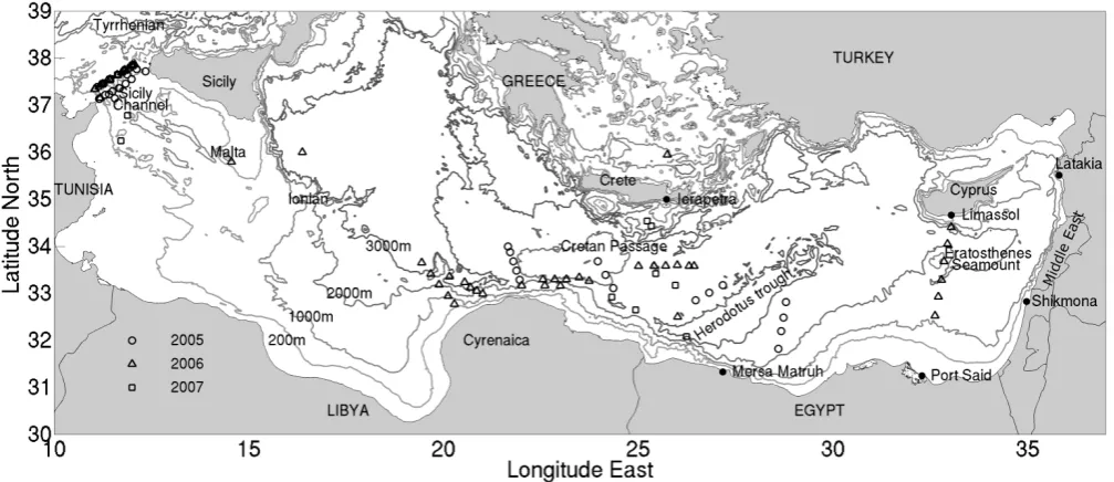
Fig. 1. Eastern Mediterranean area (30◦—39◦N, 10◦—37◦E) with geographical names and sites of drifter deployment (coded per year). The area between 20◦E and 36◦E is denoted as the Levantine sub-basin. The 200 m, 1000 m, 2000 m and 3000 m isobaths are represented in grey tones.
the Sicily Channel, crossing the Ionian north of two anticy-clonic circuits and reaching Libya near 20◦E. From there, the authors represented the flow spreading toward the open sea, so that near 25◦E it extends from the Libyo-Egyptian coast as far as south of Crete. The surface water cyclonic circuit is depicted continuously at the basin scale. Additionally, all these historical diagrams show a cyclonic circulation in the northern Ionian.
Studies performed in 1985–1992 during the international program Physical Oceanography of the Eastern Mediter-ranean (POEM) issued a different description. Robinson et al. (1991) suggested a schema in which the main feature in the Levantine is a cross-basin current that they named the Mid Mediterranean Jet (MMJ). This MMJ is depicted cross-ing northeastward from∼24◦E to southeast of Cyprus, and bifurcating to delineate circulation features such as “Mersa Matruh” and “Shikmona”. There is no surface flow along Africa. This schema was detailed later (Robinson and Gol-naraghi, 1993; Malanotte-Rizzoli et al., 1997) in the Ionian: the flow of AW, named the Atlantic Ionian Stream (AIS) in the Sicily Channel, is depicted meandering and bifurcating east of Sicily. A central branch is represented crossing the Ionian, while the northern branch extends up to 40◦N be-fore turning southward and joining the central branch off-shore Libya near 20◦E, thus describing an anticyclonic cir-cuit in the northern part of the Ionian, which is a reversal of the circulation in contrast to the previous schema. This anticyclonic circuit was also indicated by Mauerhan (2000) using drifter data in the period 1986–1999 and Lermusiaux and Robinson (2001) during the summer of 1996.
R. Gerin et al.: Surface circulation in the Eastern Mediterranean using drifters 561
Fig. 2. Edited drifter trajectories from deployment to 31 October 2007 and locations of the major sub-basin eddies analyzed: Pelops Eddy
(PE), Libyan Eddies (LE1 and LE2), Ierapetra Eddy (IE), Herodotus Trough Eddy (HTE), Eratosthenes Seamount Eddy (ESE) and Latakia Eddy (LkE).
The main path of AW along the Libyo-Egyptian slope is supported by other recent works. For example the numeri-cal simulations by Korres and Lascaratos (2003) show dur-ing summertime a coastal current (that is yet called MMJ), and those from Alhammoud et al. (2005) depict all year long the existence of an alongslope basin-scale cyclonic circula-tion with no evidence of a permanent offshore path. Studies using satellite altimetric data (Rio et al., 2007) and in situ XBT data from 1 year-long repeated transects (Fusco et al., 2003; Zervakis et al., 2003) also reach the same conclusion about the permanency of the alongslope main flow.
The scarcity of in situ observations in the southernmost parts of the basin (see e.g. Fig. 2 of Manca et al., 2004) is one of the reasons for the discrepancies of the surface circu-lation schemas. Therefore, to investigate the circucircu-lation (at all levels) and the role of the eddies in perturbing the gen-eral circulation, a joint effort was initiated, involving teams from Italy (OGS: EGITTO program, http://doga.ogs.trieste. it/sire/drifter/egitto data.html), France (LOB and LOCEAN: EGYPT program, http://www.ifremer.fr/lobtln/EGYPT/) and Tunisia (INSTM). The EGITTO/EGYPT programs included, during 2005–2007, surface drifters and Argo profiling floats, a network of moorings, hydrographic surveys, remote sens-ing measurements and numerical simulations (see Taupier-Letage et al., 2007; Beranger et al., 2007). One of the main goal was to study the surface circulation of the East-ern Mediterranean with particular focus on the Sicily Chan-nel and the southern part of the Levantine. In this paper, we present the results of the investigation of the spatial and tem-poral variability of the surface circulation in the basin using satellite-tracked drifters. The drifters and their deployment strategy are described in Sect. 2, together with information on the database, the methodology used to process the data and on the mean wind pattern in the studied area. Pseudo-Eulerian maps of the mean flow, eddy variability and energy levels are presented in Sect. 3. The whole dataset is first
con-sidered and then it is divided in two extended seasons to ex-plore the seasonal variability. The results are discussed and summarized in Sect. 4.
2 Data and methods 2.1 Drifter characteristics
The drifters used in this study are the mini WOCE-SVP (model CLEARSat-15) manufactured by Clearwater Instru-mentation. For details on the WOCE-SVP design, see Sybrandy and Niiler (1991) and Lumpkin and Pazos (2007). The surface buoy is tethered to a cylindrical drogue (with a 60-cm diameter and a 5-m height), centred at a nominal depth of 15 m. The buoy is equipped with a sea surface temperature sensor and a tension sensor that allows checking the pres-ence of the drogue. All drifters were tracked with the Argos Data Location and Collection System carried by the NOAA and METOP polar orbiting satellites. This system provided about nine locations/d with accuracy better than 1000 m (Ar-gos User’s Manual, 20081).
2.2 Strategy of deployments
A total of 97 drifters were deployed between September 2005 and March 2007 in the basin (Fig. 1 and Table 1). In the Sicily Channel and in the Ionian a seasonal variability was expected. As a result, the deployments were organized on a seasonal basis (approximately every three months). Five to six drifters were released across a transect at the entrance of the channel, both from research vessels (R/V Hannibal and R/V Urania) and from ships of opportunity (ferries). In the Levantine, no clear seasonal signal was expected from historical measurements and wind data to dictate periodic
1Available at:
https://www.argos-system.org/manual/whnjs.htm.
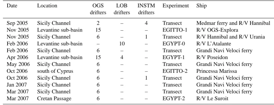
Table 1. Details on the drifter deployment episodes in the eastern basin of the Mediterranean Sea (see Fig. 1 for the geographical references):
date, location and name of the experiment, name of the ship involved and number of drifters deployed by institute.
Date Location OGS LOB INSTM Experiment Ship
drifters drifters drifters
Sep 2005 Sicily Channel 2 – 4 Transect Medmar ferry and R/V Hannibal Nov 2005 Levantine sub-basin 15 – – EGITTO-1 R/V OGS-Explora
Nov 2005 Sicily Channel 6 – 1 Transect R/V Hannibal and R/V Urania
Feb 2006 Levantine sub-basin – 10 – EGYPT-0 R/V L’Atalante
Feb 2006 Sicily Channel 6 – – Transect Grandi Navi Veloci ferry
Apr 2006 Levantine sub-basin 15 4 – EGYPT-1 R/V Poseidon
May 2006 Sicily Channel 6 – – Transect Grandi Navi Veloci ferry
Oct 2006 south of Cyprus 6 – – EGITTO-2 Princessa Marissa
Oct 2006 Sicily Channel 6 – 1 Transect Grandi Navi Veloci ferry
Jan 2007 Sicily Channel 6 – – Transect Grandi Navi Veloci ferry
Mar 2007 Sicily Channel 6 – – Transect Grandi Navi Veloci ferry
Mar 2007 Cretan Passage 6 – – EGYPT-2 R/V Le Suroit
releases. The drifters were deployed in this area (Fig. 1) mainly from ships of opportunities (transiting to Port Said), and thus the strategy was constrained by the limited ship-time available (EGITTO-1 cruise on R/V OGS-Explora in November 2005 (Poulain et al., 2006); EGYPT-0 cruise on R/V L’Atalante in February 2006; EGYPT-2 cruise on R/V Le Suroˆıt in March 2007). Whenever possible, the strat-egy focused on the sub-basin circulation features identified a priori from satellite thermal images and altimetry, as in the case of the dedicated campaign EGYPT-1 (R/V Poseidon in April 2006). Thus the drifters were mostly deployed dur-ing transects across two LEEs (LE1 and LE2), IE and one eddy over the Herodotus Trough between 28–30◦E (HTE, see Figs. 1 and 2). This latter has not been tracked yet: it may either be a LEEs or be an old IE. Finally, six drifters were also released from a ferry between Limassol (Cyprus) and Port Said (Egypt): EGITTO-2 cruise on Princesa Marissa in October 2006.
2.3 Data and processing
Among the 97 drifters deployed, 5 stopped transmitting im-mediately after deployment and were lost, while 8 were recovered and redeployed (hence being considered as new drifters). We thus obtained 100 individual trajectories that provide a database extending from 5 September 2005 to 31 October 2007 and covering the southern half of the basin (Fig. 2).
Drifter raw data were edited for outliers and spikes with automatic and manual techniques using criteria based on maximum distance, maximum speed and maximum angle between two consecutive points, as described in Poulain et al. (2004). Edited positions were interpolated at 2-h inter-vals with a kriging optimal interpolation schema (Hansen and Poulain, 1996). The interpolated positions were then low-pass filtered using a Hamming filter with cut-off period at
36-h to eliminate high frequency current components (tidal and inertial currents) and were finally sub-sampled at 6-h in-tervals. Velocity components were then estimated from cen-tred finite differences of the 6-h sub-sampled positions.
About 40% of the observations were collected by drifters which had lost their drogues (see statistics in Table 2). In order to use the maximum number of observations for the computation, undrogued drifter data can be corrected using linear regression models of the differences between nearly collocated and co-temporal undrogued and drogued drifter velocities as a function of wind (Poulain et al., 1996, 2009; Pazan and Niiler, 2001). In particular, in this pa-per, we performed such a correction using the formula-tion introduced by Poulain et al. (2009) deduced from the present EGITTO/EGYPT database and wind products from the European Centre for Medium-range Weather Forecast (ECMWF).
Following the method detailed in Poulain (2001) and Emery and Thomson (2004), we computed the pseudo-Eulerian statistics to describe the surface circulation in the basin. Kriged sub-sampled data were grouped into 0.5◦×0.5◦bins, organized on a grid with 0.25◦×0.25◦mesh size to smooth spatially the results. Bins with less than 10 observations and containing data from less than two dif-ferent drifters were rejected for the computation of the statis-tics.
R. Gerin et al.: Surface circulation in the Eastern Mediterranean using drifters 563
Fig. 3. Maps of the mean wind vectors for the extended winter
2005–2006 (a) and for the extended summer 2006 (b).
Trajectories outside the basin (i.e. north of Sicily) were not considered. Kinetic energy per unit of mass was computed and considered as the sum of two terms: the mean kinetic energy of the mean flow per unit of mass (MKE) and the mean kinetic energy of the fluctuations per unit of mass, also called eddy kinetic energy (EKE). The definitions of these statistics can be found in the Appendix A.
Additionally, to investigate the seasonal variability, includ-ing the possible reversal of the mean circulation in some areas, the pseudo-Eulerian statistics were also split in two extended seasons: the winter from November to April and the summer from May to October. This separation captures most of the seasonal variability, as already shown by Poulain and Zambianchi (2007) in the Sicily Channel. A statisti-cal analysis of temperature profiles (CTDs and XBTs) avail-able in the NODC-OGS dataset (http://nodc.ogs.trieste.it/) allowed checking that, in the basin, these extended winter and summer seasons correspond to the most homogeneous and stratified conditions of the water column, respectively. 2.4 Mean wind pattern
ECMWF wind products with 0.5◦resolution were averaged in two periods (November 2005–April 2006 and May 2006– October 2006) so as to obtain the maps of the mean wind vectors for the extended winter 2005–2006 (Fig. 3a) and the extended summer 2006 (Fig. 3b). Mean winds are stronger in summer but the variability is larger in winter. There is no significant change of wind prevailing direction in the Lev-antine. In contrast, in the Ionian, in winter the prevailing winds are from west, while during summer they turn to north or even east. Additionally, the wind products were interpo-lated at the low-pass filtered drifter position so as to relate
Table 2. Mean half life (MHL), maximum lifetime and total
drifter-days for all the drifters and for the drogued and undrogued drifters. The relative percentage of undrogued drifter data is about 40%.
MHL Max Total of
lifetime drifterdays (d) (d)
All 108 348 11377
Drogued 62 271 6747
Undrogued 53 292 4630
the drifter velocities to the local wind speed and use the cor-rection formula suggested by Poulain et al. (2009) for the undrogued drifters. The pseudo Eulerian statistics were cal-culated over separated wind regimes in the Ionian where the dominant winds are the Mistral and the Scirocco. Drifters velocities were sorted into opposite wind conditions: Mistral (northwest sector) and anti-Mistral (southeast sector) winds and drifter data with associated wind speed lower than 3 m/s were not considered.
3 Results
3.1 Total dataset
The temporal distribution of the data (Fig. 4) reveals a saw tooth shape due to the limited operational lifetime of the drifters and to the successive deployments, with strong rises in correspondence to the major deployment episodes (e.g., the EGITTO-1 cruise in November 2005, with 19 drifters re-leased). The maximum number of drifters operating simul-taneously occurred on April 2006 with 37 units. The drifter lifetime in the basin is shorter than the nominal value (auton-omy of the battery) because of the high probability of strand-ing or bestrand-ing caught by seafarers. The maximum lifetime is about one year and the mean half-life, that is the time after the deployment for which 50% of the drifters still provide useful data, is more than 100 days (see Table 2).
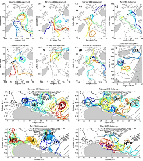
The drifter trajectories are illustrated for each deployment episode over an arbitrary time period allowing the best vi-sualization of the main circulation features (Fig. 5). Forty-two drifters were released across the Sicily Channel during seven deployment episodes (Table 1 and Fig. 5a–g). The majority of the drifters entered immediately the basin (34 over 42). However, northwestward motions to the Tyrrhenian were observed for 4 deployment episodes, especially in Oc-tober 2006 (2 out of 6 drifters, Fig. 5e) and in January 2007 (3 out of 5 drifters, Fig. 5f). The initial trajectories of the drifters in the channel are highly variable. They can display loops that are either anticyclonic, mainly in its northern part or cyclonic, mainly in its southern part.
Fig. 4. Temporal distribution of the drifter data in the basin.
Num-ber of drifterdays per day from 5 SeptemNum-ber 2005 to 31 OctoNum-ber 2007. The maximum number of drifters operating simultaneously occurred on 24 April 2006 (37 units).
East of 20◦E, the striking features (Fig. 5i–l) are the an-ticyclonic loops (especially in November 2005 and April 2006), due to the strategy of seeding drifters along transects crossing the main anticyclonic eddies: LE1, LE2, IE05 (the Ierapetra eddy resulting from the summer 2005) and HTE. The six drifters released south of Cyprus (Fig. 5h) evidenced the Eratosthenes Seamount Eddy (ESE) and additional ed-dies, then moved eastward and were trapped in the Latakia Eddy (LkE). Note that there are many other eddies, but only those with a long lifetime that could be tracked have been named.
From November 2005 to April 2006 LE1 and LE2 have drifted westward. By April 2006 both eddies are also closer to the coast. The westward drift of LE1 can be tracked until summer 2006 (Fig. 5k), but its tracking with thermal images shows that LE1 continued at least until the end of 2006 (Taupier-Letage, 2008; Sutyrin et al., 2009). During the winter 2005–2006, IE05 remained south of Crete. IE05 was seeded in April 2006, and the detailed trajectories of the drifters trapped inside (not shown) indicate that it first moved to the southeast, and then merged with the IE06 (the merging took a few days to complete, see Taupier-Letage 2008). The loops, curves and sharp bends of the trajectories indicate the presence of other eddies like south of HTE on Fig. 5i and k (red and blue tracks, respectively) and between 23◦E and 25◦E on Fig. 5j (yellow, green and blue trajectories). The tra-jectories of the drifters released in the southernmost region, when not in an eddy close to the slope, show an eastward cur-rent along the upper part of the slope, identified by the 200-m isobath between LE2 and LE1, between∼23◦E and 25◦E and∼28◦E on Fig. 5i (blue, green and orange/red trajecto-ries, respectively), from∼21◦E up to 27◦E on Fig. 5j (blue and orange), between 23–27◦E on Fig. 5l (blue and red). In-teractions between eddies and the LEC are well evidenced by the trajectory of the southernmost drifters on∼23◦300E and ∼28◦E in Fig. 5i (green and orange tracks, respectively), that of the drifter bending sharply offshore near∼27◦E in Fig. 5j (red) and those of the two drifters veering eastward inshore at∼23◦E and 24◦E in Fig. 5l (blue and red, respectively).
A striking feature is the large number of trajectories cross-ing the basin between the Libyo-Egyptian slope and Crete, especially for the drifters that are entrained first around LE2 and LE1 and then around IE05, and then, for some, back to the southern slope. There are only a few trajectories in the easternmost part of the basin. The majority follows the upper part of the slope (which is supported by the high num-ber of drifters stranded along the southern shores), but four drifters reached the Middle East slope by an offshore me-andering route. These individualized trajectories do not ev-idence any offshore continuous zonal feature, and are best visualized with the movie on http://doga.ogs.trieste.it/doga/ sire/egitto/database egitto/movies/sep05-oct07.avi.
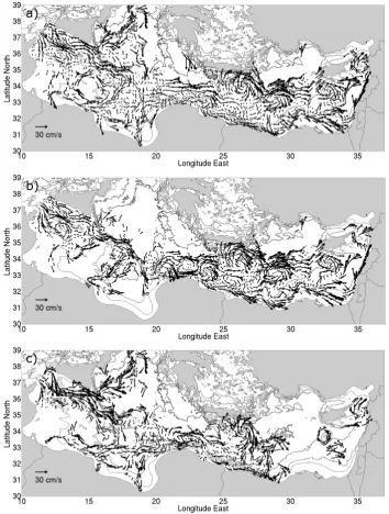
In order to delineate the areas characterized by strong cur-rents we plotted the drifter trajectories corresponding to low-pass filtered velocities larger than 30 cm/s (Fig. 6). Max-imum velocities are mainly recorded in the central part of the Sicily Channel and southeast of Sicily, and along the Libyan slope, in the southern Ionian. In the Levantine, they are observed in correspondence to the Libyo-Egyptian slope (∼200 m isobath), all the way to the Middle East. Maximum velocities also underline the position of the main eddies, es-pecially when drifters were trapped inside (LE2, LE1, IE and HTE) and evidence the importance of the eddy activity, as for instance with the offshore velocity maxima between HTE and ESE.
However, care must be taken when considering composite figures (either by overlay or averaging) since features vary markedly in both space and time. For example LE1 and LE2 have close but distinct signatures: the drifters entrained offshore around LE2 come back southward to the slope be-fore continuing south of LE1 or offshore around it (Fig. 5j). But when plotting their drift in time (e.g. in Fig. 6), between ∼20–24◦E it looks like there is only one large feature, with that on its northern side offshore there is a quasi-continuous eastward current.
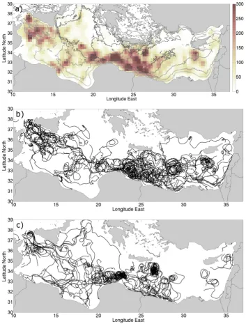
The drifter trajectory composite map (Fig. 2) and the dis-tribution of the number of observations per bins (Fig. 7a) re-veal that, generally, the spatial drifters coverage is good in the southern area of the eastern basin of the Mediterranean Sea, except in the southern Ionian and between 30◦E and 35◦E. In the Sicily Channel and in the Levantine between 20◦E and 30◦E, the dataset is dense and the number of ob-servations in 0.5◦×0.5◦bins is larger than 300.
R. Gerin et al.: Surface circulation in the Eastern Mediterranean using drifters6 R. Gerin et al.: Surface circulation in the Eastern Mediterranean using drifters565
2
4
F ig . 5 E d ite d d rif te r tr ac k s fo r ea ch d ep lo y m en t, w ith d ep lo y m e n t p o si tio n s (b la ck d o ts ). T h e 2 0 0 m , 1 0 0 0 m , 2 0 0 0 m a n d 3 0 0 0 m is o b at h s ar e re p re se n te d in g re y to n es . a ) g ) S ic ily C h a n n e l: S ep te m b er 2 0 0 5 , N o v e m b er 2 0 0 5 , F eb ru ar y 2 0 0 6 , M ay 2 0 0 6 , O ct o b er 2 0 0 6 , Ja n u ar y 2 0 0 7 an d M ar ch 2 0 0 7 d ep lo y m en ts , re sp ec tiv el y ; h ) S o u th o f C y p ru s: O ct o b er 2 0 0 6 d ep lo y m e n ts ; i) – l ) L ev an tin e su b -b as in : N o v e m b er 2 0 0 5 , F eb ru ar y 2 0 0 6 , A p ril 2 0 0 6 a n d M ar ch 2 0 0 7 d ep lo y m e n ts , re sp ec tiv el y . T h e d u ra tio n o f t h e tr ac k s is c h o se n to r ep re se n t a t b es t t h e ed d ie s an d o th er c ir cu la tio n f ea tu re s re fe rr ed to in th e te x t.2
5
F ig . 5 c o n tin u at io n2
5
F ig . 5 c o n tin u at io n2
5
F ig . 5 c o n tin u at io n2
5
F ig . 5 c o n tin u at io nFig. 5. Edited drifter tracks for each deployment, with deployment positions (black dots). The 200 m, 1000 m, 2000 m and 3000 m isobaths
are represented in grey tones. (a)–(g) Sicily Channel: September 2005, November 2005, February 2006, May 2006, October 2006, January 2007 and March 2007 deployments, respectively; (h) South of Cyprus: October 2006 deployments; (i)–(l) Levantine sub-basin: November 2005, February 2006, April 2006 and March 2007 deployments, respectively. The duration of the tracks is chosen to represent at best the eddies and other circulation features referred to in the text.
Ocean Sci., 5, 1–16, 2009 www.ocean-sci.net/5/1/2009/
Fig. 5. Edited drifter tracks for each deployment, with deployment positions (black dots). The 200 m, 1000 m, 2000 m and 3000 m isobaths
are represented in grey tones. (a)–(g) Sicily Channel: September 2005, November 2005, February 2006, May 2006, October 2006, January 2007 and March 2007 deployments, respectively; (h) South of Cyprus: October 2006 deployments; (i)–(l) Levantine sub-basin: November 2005, February 2006, April 2006 and March 2007 deployments, respectively. The duration of the tracks is chosen to represent at best the eddies and other circulation features referred to in the text.
Fig. 6. Segments of low-pass filtered drifter trajectories characterized by speeds larger than 30 cm/s. The 200 m, 1000 m, 2000 m and 3000 m
isobaths are represented in grey tones. Arrow heads indicate the flow direction.
southeasternmost part where there are only a few drifter ob-servations. The signal can be considered significant only be-tween 14◦E and 16◦E, where the number of observations increases (Fig. 7a).
The statistics do not show a clear continuity of the flow from the Ionian to the Levantine at 19–20◦E. From∼20◦E to 23◦E, there is no definitive LEC along the slope. It ap-pears east of 23◦E and continues in a cyclonic circuit off the Middle East coast. The statistical results show an offshore eastward flow starting between∼20◦E and 23◦E, that me-anders along∼34◦N. At∼24◦E, this flow appears to split. A first branch joins the alongslope LEC, either near 23◦E or between 25◦E and 27◦E. The second branch is sharply deflected towards Crete, around IE, and then continues east-ward driven, successively, by the northern edges of HTE and ESE.
This paddle-wheel effect generated by the eddies can be seen superimposing the trajectory of the drifters on con-temporaneous SST satellite images. For example, Fig. 5 of Taupier-Letage (2008) shows the trajectory of one drifter launched close to the slope near ∼22◦E diverted offshore around LE2, and then crossing the Levantine sub-basin off-shore (light blue trajectory on Fig. 5i). The meanders of the trajectory match the northern edge of successive eddies evi-denced by the SST images.
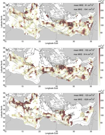
The energy level analysis reveals that large values of MKE (Fig. 9a) are prevailing in the Ionian, in correspondence to the flow crossing this sub-basin, the northward branch north-east of Sicily and the circuit centred at∼15◦E. Large val-ues also occur off Libya, between 20◦E and 24◦E, along the slope east of 23◦E and in ESE and LkE. MKE is maximum in IE and HTE, where values exceed 600 and 800 cm2/s2, respectively, and close to PE where the absolute maximum (greater than 1000 cm2/s2) is computed.
The variance ellipses (Fig. 10a) show that along the con-tinental slope, at basin-scale, the ellipses are generally flat-tened with the principal axis parallel to the slope. In the open Levantine, the ellipses are more isotropic, indicating that the fluctuating currents occur in all directions. At∼25◦E, the principal axes are oriented north-south as far as Crete, as well, but to a lesser extent, along 31◦E. The EKE (Fig. 11a) is maximum in correspondence to PE, LE1, LE2, IE (where the absolute maximum can be found) and HTE eddies as well as along the slope between 20◦E and 30◦E.
3.2 Seasonal variability
The low-pass filtered trajectories (Fig. 7b–c) divided by extended seasons reveal that the geographical coverage is broader in winter. However, the Sicily Channel, the central Ionian and the Levantine between 20 and 30◦E are well cov-ered in both seasons. The northern Ionian is mainly covcov-ered in summer, while the easternmost Levantine is mainly sam-pled during winter.
R. Gerin et al.: Surface circulation in the Eastern Mediterranean using drifters 567
Fig. 7. Data density and drifter trajectories. (a) Data density computed with the entire dataset (saturated at 300 observations per bins). The
200 m, 1000 m, 2000 m and 3000 m isobaths are represented in grey tones. (b) Low pass filtered drifter data for the extended winter. (c) Low pass filtered drifter data for the extended summer.
HTE is localized at the offshore end of the Herodotus trough and during summer at least two other eddies co-existed in the same vicinity between 27◦E and 30◦E. Finally, ESE and LkE are depicted in both seasons. During winter (Fig. 7b), one drifter delineates PE near 37◦N, 21◦E and another one identifies the cyclonic circuit south of Turkey.
The mean flow during winter (Fig. 8b) shows that the AIS entering the Sicily Channel is oriented toward south-east. Three branches can be recognized. The northern one remains parallel to the Sicily coast and enters the central
Io-nian between Sicily and Malta. The central branch meanders more southward until it joins the northern one (at ∼35◦N and∼16◦E) and then reaches Libya at 19–20◦E. The third branch flows along the Tunisian shelf, far from the coastline, since the shelf is wide there. In the southern Ionian the spatial coverage is too scarce to infer a general pattern. However, an eastward current is suggested alongslope and the trajectories perpendicular to the coast are portions of anticyclonic loops localized between 14◦E and 17◦E and between 16◦E and 20◦E.
Fig. 8. Mean flow maps obtained from the whole dataset (a), for the extended winter (b) and for the extended summer (c). The mean flow
arrows are centred at the centre of mass of the observations in each bin. Data are grouped into 0.5◦×0.5◦bins overlapped by 50% and results for bins with less than 10 observations and 2 different drifters are not plotted. The undrogued observations with a speed ratio (wind-induced slip/drifter speed) larger than 50% were not considered in the computation. The 200 m, 1000 m, 2000 m and 3000 m isobaths are represented in grey tones.
Further to the east, the alongslope LEC appears clearly from∼23◦E all the way to the Middle East. The signatures of all the eddies identified in Fig. 2 and another anticyclonic eddy (south of IE, centred at∼25◦E) are clearly visible. In the Levantine sub-basin, the winter mean flow maps display the same features pointed out in the maps obtained using the entire database (Fig. 8a), except for the signature of LE1 and LE2 that are not merged together and the evidence of the eastward alongslope flow between them.
R. Gerin et al.: Surface circulation in the Eastern Mediterranean using drifters 569
Fig. 9. MKE (saturated at 250 cm2/s2) for the whole dataset (a), for the extended winter (b) and for the extended summer (c). Data are grouped into 0.5◦×0.5◦bins overlapped by 50% and results for bins with less than 10 observations and 2 different drifters are not plotted. The undrogued observations with a speed ratio (wind-induced slip/drifter speed) larger than 50% were not considered in the computation. The 200 m, 1000 m, 2000 m and 3000 m isobaths are represented in grey tones. The red dot indicate the absolute maxima.
reversed from eastward to westward and seems to continue westward as far as 12◦E. This is likely related to the change in wind forcing (compare Fig. 3a and b) through direct (Ek-man) and indirect (geostrophic adjustment of sea level) wind effects. Indeed, the pseudo Eulerian statistics computed in this area according to the wind regimes (not shown) reveal that during Mistral events the mean flow is everywhere ori-ented to the southeast and ends on the Libyan coast at 20◦E, while during anti-Mistral regimes the flow is reversed and oriented toward northwest from 11◦E to 19◦E.
The two anticyclonic circuits in the southern Ionian, as defined in literature and already pointed out in the extended winter, are confirmed. The easternmost one is smaller than in winter and confined more to the slope.
The mean flow pattern in the Cretan Passage (the area be-tween Crete and Libya) is mainly similar to the total aver-age. However, between 20◦E and 24◦E the mean flow com-puted evidenced only one anticyclonic loop. It shows also a westward current alongslope between 20◦E and 23◦E, cor-responding to the southern part of the propagating LE2 and
570 R. Gerin et al.: Surface circulation in the Eastern Mediterranean using drifters
30
Fig. 10 Variance ellipse maps obtained from the whole dataset (a), for the extended winter (b) and for the
extended summer (c). The ellipses are centred at the centre of mass of the observations in each bin. In
all the figures, data are grouped into 0.5° x 0.5° bins overlapped by 50% and results for bins with less
than 10 observations and 2 different drifters are not plotted. The undrogued observations with a speed
ratio (wind-induced slip/drifter speed) larger than 50% were not considered in the computation. The
200 m, 1000 m, 2000 m and 3000 m isobaths are represented in grey tones.
b)
c)
Fig. 10. Variance ellipse maps obtained from the whole dataset (a), for the extended winter (b) and for the extended summer (c). The ellipses
are centred at the centre of mass of the observations in each bin. Data are grouped into 0.5◦×0.5◦bins overlapped by 50% and results for bins with less than 10 observations and 2 different drifters are not plotted. The undrogued observations with a speed ratio (wind-induced slip/drifter speed) larger than 50% were not considered in the computation. The 200 m, 1000 m, 2000 m and 3000 m isobaths are represented in grey tones.
LE1. One can also note the southward flow south of IE and HTE. As previously said, in summer drifters do not cover the easternmost part of the basin: data are scarce east of 30◦E and only spotty. ESE and LkE are well identified, as well as a cyclonic loop southeast of ESE (created by the interaction of other anticyclonic eddies seen in satellite thermal images, not shown).
R. Gerin et al.: Surface circulation in the Eastern Mediterranean using drifters 571
Fig. 11. EKE (saturated at 500 cm2/s2) for the whole dataset (a), for the extended winter (b) and for the extended summer (c). Data are grouped into 0.5◦×0.5◦bins overlapped by 50% and results for bins with less than 10 observations and 2 different drifters are not plotted. The undrogued observations with a speed ratio (wind-induced slip/drifter speed) larger than 50% were not considered in the computation. The 200 m, 1000 m, 2000 m and 3000 m isobaths are represented in grey tones. The red dot indicate the absolute maxima.
and by IE in summer (1529 cm2/s2). The area around Sicily shows a marked increase of MKE in summer with values twice the winter ones. The variance ellipses were calcu-lated for the two extended seasons (Fig. 10b–c) together with the EKE (Fig. 11b–c). A seasonal variability is evi-dent only off Sicily, while elsewhere EKE does not present much seasonal difference. The absolute maxima (764 cm2/s2 and 709 cm2/s2in winter and summer, respectively) occur in correspondence to IE in both extended seasons.
4 Discussion and conclusions
Surface drifters were deployed in the eastern basin of the Mediterranean Sea from September 2005 to March 2007, in the framework of the EGITTO/EGYPT programs, to de-scribe its surface circulation patterns. The drifter observa-tions are the first of that kind in that region, especially for the southern parts of the basin where observations were so scarce. Thanks to the high data density the computed mean
flow maps give robust information on the surface circulation in most of the basin. However the spatio-temporal variabil-ity associated with the numerous eddies is so high that it would require trajectories spanning several lifetimes of ed-dies (i.e., several years) to achieve a representative mean current. Meanwhile caution must be taken when interpret-ing these results, as for instance off the Libyan slope due to the drifting eddies LE1 and LE2. We compared the am-plitudes of the north, south, east and west velocities in the box 20–24◦E and 32–34.5◦N: the mean and the maximum velocities of the north and south components are similar to the ones in the east and west directions (the east component is greater, which accounts for the eastward general circula-tion). This shows that the offshore strong eastward current represented in the mean flow maps (e.g. Fig. 8a) is an arte-fact, in the same way as statistics can merge two propagating eddies in one single elongated eddy (as seen in Sect. 3.1).
The mean flow maps in the Ionian confirmed the Malanotte-Rizzoli et al. (1997) circulation picture providing additional information in the southern part. The main feature is an eastward flow entering the Sicily Channel and crossing the Ionian in its central part (Fig. 8a). In summer, this flow is stronger (compare Fig. 8b–c) and, east of Sicily, splits in two branches, one of which is northward as far as 39◦N and then turns anticyclonically and proceeds to the south. This anti-cyclonic elongated circuit was observed for about 10 years in the 1990s. It has been attributed to interannual variabil-ity or decadal variabilvariabil-ity (e.g. Pinardi et al., 1997; Millot and Taupier-Letage, 2005). Hamad et al. (2005) showed that it vanished from 1998, and our EGITTO/EGYPT drifters data suggest that it re-appeared in 2005–2007. However, the limited temporal extension of the database does not al-low to infer any links in these respects. In the southern part of the Sicily Channel, the surface flow is southeastward, following approximately the 200-m isobaths delineating the Tunisian slope, and corresponds to the Atlantic Tunisia Cur-rent (Poulain and Zambianchi, 2007) or to the South Tunisia vein (Millot and Taupier-Letage, 2005).
The surface water flows in the southern Ionian along the Libyan slope as confirmed by the flattened variance ellipses (Fig. 10a). However, the flow direction is not definite (east-ward from∼12 to∼17◦E; westward from∼17.5 to 18.5◦E). A seasonal reversal (already pointed out up to 16◦E by Poulain and Zambianchi, 2007) is evidenced (westward flow in summer and eastward in winter from Tunisia to Cyre-naica).
East of∼20◦E, the main feature is a continuous alongs-lope cyclonic flow off Africa (the LEC) and the Middle East. This schema generally agrees with the historical diagrams (Nielsen, 1912; Ovchinnikov, 1966; Lacombe and Tchernia, 1972) and there is a specifically good agreement with the most recent one (Millot and Taupier-Letage, 2005).
Part of the surface flow can be deflected offshore by the LEEs interacting with the LEC: on the LEEs northern sides there is locally and temporally a discontinuous eastward
off-shore current. Moreover, since eddies are numerous and in-teract frequently, surface water can be transported seaward around several successive eddies. Such a paddle-wheel ef-fect is well evidenced by the drifters launched in the south-ern coastal area and then entrained around IE05 (Fig. 5i–l): their trajectories describe several meanders offshore, corre-sponding to the northern edges of the successive eddies (see Fig. 5 of Taupier-Letage, 2008), and may succeed in reach-ing the eastern part of the basin (one made it up to Cyprus). The variance ellipses, which are flattened in a north-south direction along∼25◦E across the whole basin, further sup-port the paddle-wheel effect. But even if this may result in a net eastward transport, this does not constitute a continu-ous permanent flow, as should be a “Mid Mediterranean Jet”. Indeed, only 4 drifters spanned the longitude from 22◦E to 29◦E. Three of them, after being transported in the central part of the Levantine, ended up on the coast close to the city of Mersa Matruh (see Fig. 5 of Taupier-Letage, 2008) and only one reached Cyprus.
MKE and EKE were computed to point out the most ener-getic circulation features and the areas characterized by large variability. The energy level of the mean flow is maximum in correspondence to the eddy structures (IE and HTE are the most intense). Here the EKE is also maximum (but generally less intense than MKE), indicating that the fast current here are highly variable. MKE is maximum also all around Sicily during the extended summer, off the Middle East in winter and unevenly alongslope east of 23◦E during all the year.
Although the EGITTO/EGYPT drifter database represents an unprecedented effort (97 drifters in 18 months) for that re-gion, there are still areas and periods where data are scarce. Therefore, it is hoped that Lagrangian observations will be continued in the eastern basin of the Mediterranean Sea as part of scientific and operational oceanography programs, in order improve further our understanding of the circulation in this basin.
Appendix A
If we denote u and v as the zonal and meridional velocity (cm s−1) and use the symbol< >for the time averaging of all the data in a given bin, then the kinetic energy per unit of mass of the mean flow (MKE, cm2s−2) is:
MKE=1 2
< u >2+< v >2
.
The mean kinetic energy per unit of mass of the fluctuating flow, also called mean eddy kinetic energy (EKE, cm2s−2), is:
EKE=1 2 < u
0u0>+< v0v0> ,
where the prime indicates the residual velocity about the Eu-lerian mean, for example:
R. Gerin et al.: Surface circulation in the Eastern Mediterranean using drifters 573 and< u0u0> and < v0v0>are the variances in the zonal
and meridional direction, respectively. The principal axes of the variance ellipses are computed from the eigenvalues and the eigenvectors of the Eulerian sample covariance ma-trix (Emery and Thomson, 2004).
Acknowledgements. The authors would like to thanks all the people that helped with the drifter deployments and in particular, Mireno Borghini, Aldo Drago, Ahmed El Gindy, Mikhail Emelianov, Jean-Luc Fuda, Emiliano Gordini, Agusti Julia, Giulio Notarstefano, Gilles Rougier, Mohamed Said, Sarantis Sofi-anos and George Zodiatis. We are grateful to the captain and crew of R/V Hannibal, R/V OGS-Explora, R/V Urania, R/V L’Atalante, R/V Poseidon, R/V Le Suroit, Princessa Marisa and the Medmar and Grandi Navi Veloci Ferries for their precious help with the drifter deployments. The EGITTO project was partially supported by the Office of Naval Research under grants N000140510281 and N000140610391. The EGYPT project received funding from CNRS/INSU, programs LEFE/IDAO (PATOM) and Groupe de Mission Mercator Coriolis (GMMC), and the R´egion Provence Alpes Cˆote d’Azur. We thank the reviewers for their constructive comments on the original version of the manuscript.
Edited by: K. J. Heywood
References
Alhammoud, B., B´eranger, K., Mortier, L., Cr´epon, M., and Dekeyser, I.: Surface circulation of the Levantine Basin: compar-ison of model results with observations, Prog. Oceanogr., 66(2– 4), 299–320, 2005.
Beranger, K., Taupier-Letage, I., Alhammoud, B., Lellouche, J. M., Emelianov, M., Mortier, L., and Millot, C.: Analysis of two mesoscale eddies in the southern Ionian and Cretan basins in 2006, Rapp. Comm. Int. Mer Medit., 38 pp., 2007.
Emery, W. J. and Thomson, R. E.: Data Analysis Methods in Phys-ical Oceanography, Elsevier, Amsterdam, 638 pp., 2004. Fusco, G., Manzella, G. M. R., Cruzado, A., Gacic, M.,
Gas-parini, G. P., Kovacevic, V., Millot, C., Tziavos, C., Velasquez, Z. R., Walne, A., Zervakis, V., and Zodiatis, G.: Variability of mesoscale features in the Mediterranean Sea from XBT data analysis, Ann. Geophys., 21, 21–32, 2003,
http://www.ann-geophys.net/21/21/2003/.
Hamad, N., Millot, C., and Taupier-Letage, I.: A new hypothesis about the surface circulation in the eastern basin of the Mediter-ranean sea, Prog. Oceanogr., 66, 287–298, 2005.
Hamad, N., Millot, C., and Taupier-Letage, I.: The surface circu-lation in the eastern basin of the Mediterranean Sea, Sci. Mar., 70(3), 457–503, 2006.
Hansen, D. V. and Poulain, P.-M.: Processing of WOCE/TOGA drifter data, J. Atmos. Ocean. Tech., 13, 900–909, 1996. Korres, G. and Lascaratos, A.: A one-way nested eddy resolving
model of the Aegean and Levantine basins: implementation and climatological runs, Ann. Geophys., 21, 205–220, 2003, http://www.ann-geophys.net/21/205/2003/.
Lacombe, H. and Tchernia, P.: Caract`eres hydrologiques et circu-lation des eaux en M´editerran´ee, Mediterranean Sea, edited by: Stanley, D., Dowden, Hutchinson and Ross, Stroudsburg, 25–36, 1972.
Lermusiaux, P. F. J. and Robinson, A. R.: Features of dominant mesoscale variability, circulation patterns and dynamics in the Strait of Sicily, Deep-See Res. Pt. I, 48, 1953–1997, 2001. Lumpkin, R. and Pazos, M.: Measuring surface currents with
Sur-face Velocity Program drifters: the instrument, its data, and some recent results, Chapter two of Lagrangian Analysis and Predic-tion of Coastal and Ocean Dynamics (LAPCOD), edited by: Griffa, A., Kirwan, A. D., Mariano, A. J., Ozgokmen, T., and Rossby, T., Cambridge University Press, 39–67, 2007.
Malanotte-Rizzoli, P., Manca, B., Ribera D’Alcala, M., Theocharis, A., Bergamasco, A., Bregant, D., Budillon, G., Civitarese, G., Georgopoulos, D., Michelato, A., Sansone, E., Scarazzato, P., and Souvermezoglou, E.: A synthesis of the Ionian Sea hydrog-raphy, circulation and water mass pathway during POEM-Phase I, Prog. Oceanogr., 39, 153–204, 1997.
Manca, B., Burca, M., Giorgetti, A.,Coatanoan, C., Garcia, M.-J., and Iona, A.: Physical and biochemical averaged vertical pro-files in the Mediterranean regions: an important tool to trace the climatology of water masses and to validate incoming data from operational oceanography, J. Marine Syst., 48, 83–116, 2004. Mauerhan, T.: Drifter observations of the Mediterranean Sea
sur-face circulation, Master thesis, Naval Postgraduated School, Monterey, CA, 114 pp., 2004.
Millot, C. and Taupier-Letage, I.: Circulation in the Mediterranean Sea, The Handbook of Environmental Chemistry, Volume K, 29– 66, doi:10.1007/b107143, May 2005.
Nielsen, J. N.: Hydrography of the Mediterranean and adjacent wa-ters, Rep. Dan. Oceanogr. Exp. Medit., 1, 77–192, 1912. Ovchinnikov, I. M.: Circulation in the surface and intermediate
layer of the Mediterranean, Oceanology, 6, 48–59, 1966. Pazan, S. E. and Niiler, P. P.: Recovery of near-surface velocity
from undrogued drifters, J. Atmos. Ocean. Tech., 18, 476–489, 2001.
Pinardi, N., Korres, G., Lascaratos, A., Roussenov, V., and Stanev, E.: A seasonal model of the Mediterranean Sea general circula-tion, Geophys. Res. Lett., 24, 425–428, 1997.
Poulain, P.-M., Warn-Varnas, A., and Niiler, P. P.: Near-surface cir-culation in the Nordic seas as measured by Lagrangian drifters, J. Geophys. Res., 101(C8), 18237–18258, 1996.
Poulain, P.-M.: Adriatic Sea surface circulation as derived from drifter data between 1990 and 1999, J. Marine Syst., 29, 3–32, 2001.
Poulain, P.-M., Barbanti, R., Cecco, R., Fayes, C., Mauri, E., Ursella, L., and Zanasca, P.: Mediterranean surface drifter database: 2 June 1986 to 11 November 1999, Rel. 75/2004/OGA/31, OGS, Trieste, Italy (CDRom and online dataset http://poseidon.ogs.trieste.it/drifter/database med), 2004. Poulain, P.-M., Taupier-Letage, I., Gerin, R., Barbanti, R., Deponte, D., and Notarstefano, G.: Oceanographic Cruise EGITTO-1 R/V OGS - EXPLORA 11-18 November 2005 Trieste, Italy to Port Said, Egypt, Cruise Report, Rel. 29/2006/OGA/14, OGS, Trieste, Italy, 2006.
Poulain, P.-M. and Zambianchi, E.: Surface circulation in the cen-tral Mediterranean Sea as deduced from Lagrangian drifters in the 1990s, Cont. Shelf Res., 27(7), 981–1001, 2007.
Poulain, P.-M., Gerin, R., Mauri, E., and Pennel, R.: Wind effects on drogued and undrogued drifters in the Eastern Mediterranean, J. Atmos. Ocean. Tech., 26, 1144–1156, 2009.
Rio, M.-H., Poulain, P.-M., Pascual, A., Mauri, E., Larnicol, G., and Santoleri, R.: A Mean Dynamic topography of the Mediter-ranean Sea computed from altimetric data, in-situ measurements and a general circulation model, J. Marine Syst., 65, 484–508, 2007.
Robinson, A. R., Golnaraghi, M., Lesile, W. G., Artegiani, A., Hecht, A., Lazzoni, E., Michelato, A., Sansone, E., Theocharis, A., and Unluata, U.: The Eastern Mediterranean general circula-tion: features, structure and variability, Dynam. Atmos. Oceans, 15, 215–240, 1991.
Robinson, A. R. and Golnaraghi, M.: Circulation and dynamics of the Eastern Mediterranean Sea; Quasi-Synoptic data-driven sim-ulation, Deep-Sea Res., 40(6), 1207–1246, 1993.
Sybrandy, A. L. and Niiler, P. P.: WOCE/TOGA Lagrangian drifter construction manual, Scripps Institution of Oceanography, San Diego, California, SIO REF 91/6, WOCE Report 63, 1991.
Sutyrin, G., Stegner, A., Taupier-Letage, I., and Teinturier, S.: Am-plification of a Surface-Intensified Eddy Drift along a Steep Shelf in the Eastern Mediterranean Sea, J. Phys. Oceanogr., 39(7), 1729-1741, 2009.
Taupier-Letage, I. and the EGYPT/EGITTO Teams: New elements on the surface circulation in the eastern basin of the Mediter-ranean, Rapp. Comm. Int. Mer. Medit., 38 pp., 2007.
Taupier-Letage, I.: On the use of thermal infrared images for cir-culation studies: applications to the eastern Mediterranean basin, in: Remote sensing of the European Seas, edited by: Barale, V. and Gade, M., Springer Netherlands, 153–164, 2008.
Zervakis, V., Papadoniou, G., Tziavos, C., and Lascaratos, A.: Seasonal variability and geostrophic circulation in the eastern Mediterranean as revealed through a repeated XBT transect, Ann. Geophys., 21, 33–47, 2003,