World Maritime University
The Maritime Commons: Digital Repository of the World
Maritime University
World Maritime University Dissertations Dissertations
2015
Vessel traffic service as a maritime security tool:
vessel traffic management information systems
(VTMIS) in Ghana
Joseph Akwasi Kuma
World Maritime University
Follow this and additional works at:http://commons.wmu.se/all_dissertations Part of theNavigation, Guidance, Control and Dynamics Commons
This Dissertation is brought to you courtesy of Maritime Commons. Open Access items may be downloaded for non-commercial, fair use academic
Recommended Citation
Kuma, Joseph Akwasi, "Vessel traffic service as a maritime security tool: vessel traffic management information systems (VTMIS) in Ghana" (2015).World Maritime University Dissertations. 493.
WORLD MARITIME UNIVERSITY
Malmo Sweden
DISSERTATION
VESSEL TRAFFIC SERVICE AS A MARITIME
SECURITY TOOL: VESSEL TRAFFIC
MANAGEMENT INFORMATION SYSTEMS
(VTMIS) IN GHANA
By
JOSEPH AKWASI KUMA
Ghana
A dissertation submitted to the World Maritime University in partial Fulfillment of the requirements for the award of the degree of
MASTER OF SCIENCE
In
MARITIME AFFAIRS
(MARITIME SAFETY AND ENVIRONMENTAL ADMINISTRATION.)
DECLARATION
I certify that, all the material in this dissertation that is not my own work has been
identified and that no material is included for which a degree has previously been
conferred on me.
The content of this dissertation reflect my own personal views and are not necessarily
endorsed by the University.
(Signature): ………
(Date): ………
Supervised by: Professor Dimitrios Dalaklis
World Maritime University
Assessor: Raza Mehdi
Institution/organization: World Maritime University
Co-assessor: Professor Nikitas Nikitakos
ACKNOWLEDGEMENT
I deem it a great honour to express my profound gratitude to the God almighty for giving
me the strength and life and seeing me through the programme successfully. I sincerely
thank Captain Dallas Laryea, the IMO representative for West and Central Africa, for
the great support of the provision of scholarship that enabled me to embark on this
pursuit to enhance my academic knowledge.
I am extremely indebted to my supervisor, Professor Dimitrios Dalaklis. His expert
guidance, valuable support and encouragement saw me through this interesting yet
challenging research work successfully.
Special thanks also go to Ms. Janet Houghman-Addy and Madam Comfort Dogbatse for
their love and prayers. To Mr. Peter Issacha Azuma, the Director-General of Ghana
Maritime Authority and the entire staff of the Authority, I say thank you.
Furthermore, I again wish to express my gratitude to Mr. and Mrs. Mpare for their
unflinching love and support.
I would like to thank Professor Jens-Uwe Schroder- Hindrichs and the department of
Maritime Safety and Environmental Administration for the valuable lectures and
knowledge imparted to me throughout my studies and their availability whenever we
needed their assistance.
For the role played in ensuring I attend this prestigious institution, I specially thank
Susana Perlheden and Susan Jackson of the World Maritime University.
To the management of all the institutions which participated in the survey exercise, I am
very grateful to you for allowing me to use your outfit and also for participating in the
A big thank you also goes to Augustine Chongaterah for his brotherly advice and
support.
Lastly, I express my sincere gratitude to my Mum, Janet Bonsu for her prayers and
ABSTRACT
Tittle of Dissertation: Vessel Traffic Service as a Maritime Security Tool: Vessel Traffic Management Information Systems (VTMIS) in Ghana
Degree: MSc
The dissertation is an assessment of the role of the VTMIS in enhancing efforts to bring down maritime security in the threats in the Gulf of Guinea in West Africa focusing on Ghana.
According to the International Maritime Organisation (IMO), Vessel Traffic Service (VTS) is implemented by a Competent Authority to improve the safety and efficiency of vessel traffic and to protect the environment. Technological development today has led to significant improvements in vessel traffic service. Vessel Traffic Management Information Service is the integration of Management information systems to improve the quality of vessel traffic services. Vessel traffic services essentially are used for information services, navigational assistance services, traffic organisation services, and similar allied services. Increasingly, threats to maritime safety and security in the Gulf of Guinea area are becoming major issues in the world. This study investigated the role of the VTMIS in Ghana in enhancing and combating maritime security threat such as piracy, smuggling and trafficking, in the Gulf of Guinea area. The study collected primary qualitative data from respondents from agencies in Ghana that uses information from the VTMIS for the assessment. It also relied on secondary data from the IMO and Ghana Maritime Authority on incidence of piracy in the Gulf of Guinea. The study revealed that VTMIS in Ghana contributes significantly to security of offshore installations in Ghana. It also reveal that Ghana’s VTMIS contributes significantly in monitoring and reporting maritime security issues in the Gulf of Guinea area.
Table of Contents
Declaration... ii
Acknowledgement ... iii
Abstract ... v
Table of Contents ... vi
List of Table ... viii
List of Figures ... ix
List of Abbreviations ... x
CHAPTER ONE ... 1
1.1 Background of the study ... 1
1.2 Problem Statement ... 2
1.3 Research Objective ... 3
1.4 Research Questions ... 3
1.5 Significance of Study ... 4
1.6 Scope, Limitation and delimitation ... 4
1.7 Structure of Thesis ... 5
CHAPTER TWO ... 6
2.1 Sources of Data ... 6
2.2 Research Method ... 7
2.3 Research Participants ... 8
2.4 Interview Procedure ... 9
2.5 Data collection Process ... 13
2.6 Limitation ... 14
2.7 Ethical issues ... 15
CHAPTER THREE ... 16
3.1 Introduction ... 16
3.2 Development of Vessel Traffic Service (VTS) ... 17
3.3 IMO Guidelines for Operating VTS ... 19
3.4 IMO Legislation on VTS ... 20
3.6 Essential Components of a VTS System ... 25
3.7 Vessel Traffic Management and Information Services/System (VTMIS) ... 27
3.8 Definition of Maritime Security ... 29
3.9 Maritime Security in the Gulf of Guinea (GoG) ... 34
3.10 VTMIS and Maritime Security ... 38
3.11 The Nature of VTS/VTMIS in Ghana ... 42
3.12 Hardware and Software Components ... 46
3.13 Conclusion ... 51
CHAPTER FOUR ... 53
4.1 Introduction ... 53
4.2 The Components of VTMIS in Ghana ... 54
4.3 VTMIS contribution to Security of Offshore installations in Ghana ... 57
4.4 Protection of the West African Gas Pipeline ... 60
4.5 Protection of the Oil Fields and Private cables ... 62
4.6 Fighting Maritime Crime in the GoG with VTMIS ... 63
4.7 Data on Maritime Crime ... 64
4.8 Shortfalls of the VTMIS in Ghana ... 69
4.9 Conclusion ... 70
CHAPTER FIVE ... 72
MAJOR FINDINGS AND RECOMMENDATIONS... 72
5.1 Findings... 72
5.2 Recommendations ... 73
REFERENCES ... 75
LIST OF TABLE
Table 1: Extract from regional analysis of reports on acts of piracy and
armed robbery in West Africa ………..33
Table 2: Incidents of Piracy in 2014 and 2015 in the GoG……….58
LIST FIGURES
Figure 1: Three-component-model of VTS………...……….…24
Figure 2: Components of a VTMIS………..……..26
Figure 3: Maritime Security Matrix………...………….27
Figure 4: Maps of West Africa indicating the Gulf of Guinea area………...……….32
Figure 5: Radar (top Rotherdam-Netherlands, left side: Zandvliet-Belgium,
right: Genova-Italy)………..……...36
Figure 6: Overview of NCC and Area Control Centre of Ghana’s VTMIS…….…...40
Figure 7: Control Centres at A: Accra (GMA HQ) and B: Takoradi (WCC)……….41
Figure 8: Workstations and Display unites at the control centres of the
VTMIS in Ghana ………...……….42
Figure 9: GMDSS (VHF DSC) set at Ghana………...………43
Figure 10: Equipment setup at Ghana’s VTMIS Monitoring Stations ………...……44
Figure 11: Equipment at the VTMIS RSS and RBS………..………45
Figure 12: The West Africa Gas Pipeline………....55
Figure 13: Screen shots of the Jubilee field coverage showing the
LIST OF ABBREVIATIONS
AIS Automatic Identification System
AU African Union
AVR Automatic Voltage Regulator
CCTV Closed Circuit Television
DSC Digital Selective Calling
ECC Eastern Control Centre
ECOWAS Economic Community of West African States
FPSO Floating Production Storage and Offloading
GMA Ghana Maritime Authority
GMDSS Global Maritime Distress and Safety System
GoG Gulf of Guinea
GPS Global Positioning System
HQ Head Quarters
IMO International Maritime Organisation
IALA International Association of Lighthouse
Authorities
ITU International Telecommunication Union
ISPS International Ship and Port Facility Security Code
IEEE Institute of Electrical and Electronic Engineers
IMO International Maritime Organisation
IUU llegal, Unreported and Unregulated
ICT Information Communication Technology
LRIT Long Range Identification and Tracking
MSM Maritime Security Matrix
MSC Maritime Safety Committee
NATO North Atlantic Treaty Organisation
NCC National Control Center
NM Nautical Mile
VTS Vessel Traffic Service
VTMIS Vessel Traffic Monitoring Information Systems
RBS Remote Based Station
RSS Remote Sensor Site
SAR Search And Rescue
SOLAS Safety of Life at Sea
STCW Standard of Training Certification and
Watchkeeping
UNCLOS United Nations Convention on the Law of the Sea
UPS Uninterruptible Power Supply
VHF Very High Frequency
WAGP West African Gas Pipeline
WAPCO West African Gas Pipeline Company Limited
CHAPTER ONE
INTRODUCTION
1.1 Background of the study
Maritime security is an integral to the success of the worldwide maritime transportation
chain. Major threats to maritime security include terrorism, unlawful acts such as piracy
and arm robbery at sea, smuggling of migrants and drugs, threats to resource security,
and environmental threats such as pollution incidents and illegal dumping (Ameri and
Shewchuk, 2007). Maritime Security is therefore the combination of preventive and
responsive measures to protect the maritime domain against threats and intentional
unlawful acts (Feldt, Roell, and Thiel, 2013). According to researchers such as Ameri
and Shewchuk (2007), maritime security and safety are complimentary concepts with
common objectives. Feldt et at. (2013, p1) stated that “maritime safety is the
combination of preventive and responsive measures intended to protect the maritime
domain against, and limit the effect of, accidental or natural danger, harm, and damage
to the environment, risks or loss.”
Both security and safety have been major areas of concern to the International Maritime
Organization (IMO) and the international community. The International Convention for
the Safety of Life at Sea (SOLAS), 1974 has provided standard guidelines for
enhancing maritime security. Following the 9/11 attacks in the United States (US) a
comprehensive set of measures contained in the International Ship and Port Facility
Security Code (ISPS Code) were developed to enhance the security of ships and port
facilities (International Maritime Organization, 2015). The adoption of Resolution
A.578 (14) ‘guidelines for vessel traffic services’ by the IMO was also focused on
Association of Marine Aids, 2012). The original guidelines for vessel traffic services
were revised and adopted in 1997 as Resolution A.857 (20). IMO defined Vessel traffic
service (VTS) in this new resolution as “a service implemented by a Competent
Authority, designed to improve the safety and efficiency of vessel traffic and to protect
the environment” (International Maritime Organization, 1997, p.3).
The purpose of a Vessel Traffic Service (VTS) is to provide active monitoring and
navigational advice for vessels in busy waterways (United States Coast Guard, 2015).
According to the European Commission (2008) VTS systems are intended to ensure
maritime safety in particular areas of dense shipping. The IMO identifies three
categories of services provided by VTS systems including information services, traffic
organization services, and navigational assistance services (International Maritime
Organization, 1997). VTS systems consist of land based control centers that receive
information from sensors such as radar, Automatic Identification System (AIS) and
closed circuit television (CCTV) (European Commission, 2008). Some VTS systems
also integrate Long Range Identification and Tracking (LRIT) data centers to enable
them identify and track ships globally. VTS installations therefore provide valuable
surveillance information on offshore infrastructures such as oilrigs, seabed cables, and
pipelines. According to the European Commission’s report, VTS systems include
mechanisms for tracking, receiving and reporting distress messages from vessels and
therefore help in fighting maritime crime.
1.2 Problem Statement
According to the Royal Institute of International Affairs report released in 2013, piracy,
armed robbery at sea, and illegal fishing are on the ascendency in the Gulf of Guinea
(GoG) area. There have been collaborative actions by coastal countries in West Africa
to reverse the situation in order to ensure the security of maritime activities in the GoG
its establishment in many countries is very slow. One major factor accounting for this is
due to the fact that there has not been much empirical assessment of its role in
enhancing maritime security. Using the Vessel Traffic Management and Information
System (VTMIS) in Ghana as basis, the main objective of this study is to discuss the
role of VTS in enhancing maritime security in the GoG Region. This thesis will identify
both weaknesses and strengths of VTS in enhancing maritime security. Anyiam (2014,
p12) recommended “GoG states must invest in modern technology in their efforts to combat maritime crime.” He argued that VTS systems equipped with AIS and LRIT “could be useful for purposes of maritime security surveillance.” The potency of this
recommendation will be tested in this thesis.
1.3 Research Objective
To assess the role of VTS in enhancing maritime security in the GoG area and work
specifically to:
1. To investigate how VTS can contribute to the increase of security level of
offshore installations ( pipe lines, oil rigs, cables etc)
2. To access how VTS capabilities are integrated in the effort to fight against crime
in the GoG.
3. To identity short falls in it use and propose ways to overcome.
1.4 Research Questions
1. How can VTS be used to provide security monitoring of offshore installations?
2. How can VTS be integrated in the effort against crime in the GoG?
3. What are the short falls in the use of VTS as a security tool and how can they be
1.5 Significance of Study
West Africa is identified as part of the prone areas of maritime piracy in the
contemporary era. Most of the reported incidents in the GoG are violent actions for the
purpose of stealing. Although most unlawful acts against vessels in the GoG are
erroneously reported, there is general consensus that the rate of such unlawful acts is on
the increase in recent years (Anyiam, 2014). Anyiam’s report stated that between 1995
and 2014, about 843 incidents of acts considered unlawful against vessels were
reported. This study is significant because it will help understand how VTS can
contribute in the reduction of unlawful acts against vessels in the GoG. It will also
source of information to researchers and pave the way for future research in the area of
VTS in the GoG region.
1.6 Scope, Limitation and delimitation
The scope of study is limited to the use of VTS in maritime security areas such as
unlawful acts against vessels and protection of offshore infrastructure. The IMO
resolution (A857 (20)) that provides the guidelines for vessel traffic services identifies
three categories of services provided by VTS systems. These include information
services, traffic organization services, and navigational assistance services. Primarily,
the VTMIS in Ghana is being used as an information service tool and aid to maritime
Search and Rescue (SAR) operations. This therefore defined the focus of the study to
assess how VTMIS is used in the fight against maritime crime. If other countries like
Nigeria, Liberia, and Ivory Coast had VTMIS systems the scope of the study could have
been broader. However, Ghana is the only country with a VTS system in the GoG
region presently. The study would therefore relay on information solely from Ghana’s
1.7 Structure of Thesis
The study is divided into five chapters. In chapter one the background and research
problem is presented. In this chapter, the relationship between VTS and maritime
security and safety is also discussed as well as the research problem and objectives. The
justifications for the research and limitations have also been discussed. In Chapter Two,
the research methods were discussed. Included in this chapter is a discussion on the
sources of data, qualitative research method, targeted group, sampling technique, and
ethical issues. The reasons for choice of qualitative method and choice of sampling
techniques will be explained. Chapter Three reviewed related literature on VTS and
maritime security and safety. The review focused on the use of VTS in protecting
offshore installations and in fighting crime. In addition, literature on the shortfalls of
VTS in achieving maritime security was reviewed. This helped identify the gaps in
literature on maritime security and safety and VTMIS to be addressed. The fourth
Chapter discussed qualitative data collected. The discussions are themed under the sub
objectives of the study. Chapter Five will present a summary of the results in Chapter
Four. It will also state the findings of the study and recommendations for policy makers
CHAPTER TWO
RESEARCH METHODS
2.1 Sources of Data
Data will be collected from both primary and secondary sources for the study. Primary
data is first hand information for a particular investigation. According to Currie (2015,
p.89) “primary data are data that were previously unknown and which have been
obtained directly by the researcher for a particular research project.” According to
ACAPS (2012, p.3); “primary data is most generally understood as data gathered from
the information source and which has not undergone analysis before being included in
the needs assessment. Primary data is collected directly from the affected population by
the assessment team through field work.” On the other hand, secondary data refers to
data collected by other researchers that already exist in the literature (University of
Surrey, 2014). According to ACAPS, “secondary data is information which has
typically been collected by researchers not involved in the current assessment and has
undergone at least one layer of analysis prior to inclusion in the needs assessment.
Secondary data can comprise published research, internet materials, media reports, and
data which has been cleaned, analysed and collected for a purpose other than the need
assessment, such as academic research or an agency or sector specific monitoring
reports.” This was used in the review of literature for finding gaps that needed answers.
It provided useful information and serve as a source of historical data on VTS and
maritime security in the GoG.
Particularly, the following secondary data was used in the investigation: reports on
VTMIS by GMA, The IALA publications, Hart (2014), Professors Dalaklis, Siousiouras
and Nikitakos (2009), and the International Maritime Organization, (2015). GISIS:
documentation on VTS from IALA will. The information from Professors Dalaklis,
Siousiouras and Nikitakos (2009) on the advantages of VTMIS in Greece was compared
with the VTMIS in Ghana to identify similarities and differences. The data from the
International Maritime Organization (2015) online database on the regional statistics on
unlawful acts such as piracy and armed robbery and other related crimes served as
guided information in the discussion of results. The IMO’s data together with Hart
(2014) reviews on trends in maritime crime in the GoG was used in understanding the
nature of maritime security threats in the region.
2.2 Research Method
In every investigation, the choice of a particular method (or methods) is a very
important decision because it affects the results of the entire research. The kind of data
that we need determines how we should go about collecting it and what methods we
should adopt (Currie, 2015). ACAPS (2012) stated that “qualitative research explores
information from the perspective of both groups and individuals and generates case
studies and summaries rather than lists of numeric data.” Upon careful evaluation of the
nature of the topic the qualitative research method was therefore employed in gathering
first primary data. Parkinson and Drislane (2011) defined qualitative research as the
type that uses methods such as participant observation or case studies which result in a
narrative or descriptive account of a setting or practice. Such data are often textual
observations that portray attitudes, perceptions or intentions. Qualitative research has
also been defined as research that uses data that do not indicate ordinal values (Guest,
Namey, and Mitchell, 2013). Whereas quantitative research focuses on how many and
how much, qualitative data answer questions of how and why events of phenomena
exist.
According to the University of Surrey, 2014 the benefits of the qualitative approach is
Research in maritime security requires detailed data. However, in many cases this
information is often classified coupled with the fact that VTS systems are equipped with
high tech devices that gather data for analysis and use. As stated by Guest, Namey, and
Mitchell (2013), the advantage of qualitative research is the ability to probe into
responses and observations as needed and obtain more detailed descriptions and
explanations of experiences. Patton and Cochran (2002) added that when it comes to
face validity, the qualitative data acquisition process provides an additional advantage.
Another advantage of the qualitative approach is that it explores relationships and
perceptions held by affected persons and communities. Consequently, smaller sample
sizes chosen purposefully is advantageous because “some informants are more likely to provide greater insight and understanding of a disaster’s impact to the assessment team,
due to a variety of factors including their social, economic, educational, and cultural
position in the community” (ACAPS, 2012, p.8). At this early stage of the VTMIS
phase in Ghana a research method that allows careful consideration of participants
would yield better results than when someone is selected at random to answer a
qualitative question. This research method was able to collect rich and detailed
information in a limited time and resources.
2.3 Research Participants
According to ACAPS (2012, p.11) key informant interviews provide vital information
on individual perspectives and experiences through direct discussion. The reports
defined a key informant, as a person with prior knowledge of the issues in a community
who can provide information on behalf of the community on the impact of such issues
and on the priority community needs. It added questions meant for key informant seek
to explore the impact of the issue on the community as a whole. The data collected can
be combined and analysed to develop an understanding of how for example “an issue
what their ensuing priority needs and concerns are and are likely to be over time.” This
research was done primarily with key informants from varies state agencies that uses
the VTMIS in Ghana.
The Ghana Maritime Authority is the state agency responsible for maritime
administration; this agency established and operates the VTMIS in Ghana. Nonetheless
other stakeholders in the maritime industry in the country are given monitoring stations
to aid them in their operations. In order to collect information from different
perspectives and experiences, two participants where interviewed from the GMA and
the other state agencies including the Ghana Ports and Harbours Authority, Narcotics
Control Board, Fisheries Department, Immigration Service, and, Ghana Navy, as well
as the Customs and Preventive Service. The participants were selected to answer
questions sent via email, Google docs forms, and or interviewed on phone.
2.4 Interview Procedure
Interviews are the central technique in qualitative inquires because it allows complexity
of process to be captured with just a handful of individuals (Moayoux, 2011; Patton and
Cochran, 2002). This study used in-depth interview technique in acquiring data from
the participants. Open-ended interview offers the interviewer the ability to ask question
in different ways and from different angles. These help the participants to understand
the issues of the study and offer rich data for the researcher. ACAPS (2012, p.3)
“primary data is most often collected through face to face interviews or discussions with
members of the affected community, but can also be gathered through phone interviews,
radio communication, email exchange, and direct observation.”
On the forms that were sent via email or Google docs to participants, excerpts from the
questions. During the introduction, participants were also told that all the information
collected for the study would be treated with confidentiality. Participants were first
asked to state the name of their organisation. In the Google Form this was set as a
“required” response. This action was necessary to differentiate the government agencies
that they belong. This will also guide in the interpretation of their responses, because
the different agencies used the information from the VTMIS to meet their own
operations.
Apart from the introduction, the main investigation was structured into fourteen
questions. The interviews questions were carefully designed to cover the objectives of
the study. The study intended to investigate how VTS can contribute to the increase
security level of offshore installations; to access how VTS capabilities are integrated in
the effort to reduce maritime crime in the GoG; and identity short falls of the system.
The questions that were used for the interviews are discussed in detail bellow.
What is your background?
The first question was required to understand the participant’s background, work
experience, current job specification and expertise. Their shared experience brought
about an understanding and appreciation of their response to questions.
Could you take me through the general set-up of the VTS system in Ghana? (in terms
of infrastructure).
The second interview question was meant to understand whether, the participants who
were drawn from agencies in Ghana had adequate knowledge about how the VTMIS
was set-up. Although this question was meant to test their understanding of the physical
set-up in terms of infrastructure and network, it is understood that these are very
for other participants outside of GMA, mere understanding of the departments that were
linkup as well as the source of the information was considered as enough.
What are the usefulness of the VTMIS to Ghana and the West African sub-region?
Question three, was formulated to test general theoretical knowledge of the possible
uses of VTMIS in Ghana and West African region. Respondents general knowledge
helped understand how they are using the system now and how they could use it in the
future. This contributed information to answering the second sub-objective.
Are there other government agencies that benefit from the VTMIS? (If so list them
and the nature of information they receive from VTMIS)
This was linked up to the knowledge of general usefulness of VTMIS. The system
integrated government agencies in the maritime sector to share vessel traffic
information for purposes of safety, planning and prevention of crime in the maritime
domain. The question will help understand the various agencies linked up in the VTMIS
and the kind of information deemed useful to that agencies.
Are there targeted areas during VTMIS operations? i.e.: (Restricted zones, or areas
where pipeline are laid)
This question was targeted at the GMA respondents to know whether during operations
they monitor certain restricted zone in Ghana’s waters. Focus areas including areas
demarcated as areas to be avoided, pipelines, other state protected areas, zones where
fishing is not allowed etc. This question helped to investigate the first sub-objective of
the study.
What are the communication mediums used in the VTMIS to contact and
Question six intended to list the various options available in the system for establishing
communication via voice (audio) and text to vessel. It also included medium on which
internal communication between VTS centres and monitoring stations are done. This
brought understanding as to what assistance the VTMIS could offer to vessels such as in
time of distress. The options available and how effective they are partly determines how
reliable the VTMIS is.
How far in terms of nautical miles is the coverage area of Ghana’s VTMIS?
The coverage area of the system is also important. This question helped to identify the
different devices that fed data into the VTMIS and how far in nautical miles the coast of
Ghana was covered. This would help to understand whether the system could identify
unlawful acts in the areas away from the coastline and the territorial waters.
How can VTS be used to provide security monitoring of offshore installations?
This question intended to find out how VTS is used in practical terms to monitor state
and private infrastructure along the coast of Ghana. The answers brought about
information on how it is used currently, and how it can be improved in the future to
enhance maritime security.
What is the role of VTMIS in ensuring maritime security?
The question was meant to test the roles Ghana’s VTMIS is playing in preventing and combating maritime security threats along the GoG specifically within the nations’ maritime domain. Respondent’s views on maritime security were different, so the
definition adopted in the literature was applied to issues listed. Maritime security
includes a wide variety of issues. The study adopted (Bueger, 2014) semiotics concept
concepts such as maritime safety, blue economy, and human resilience. This question
directly answered sub-objective two.
How can VTS be integrated in the fight against crime in the GoG?
Sub-objective two, intended “to access how VTS capabilities are integrated in the effort
to fight against crime in the GoG.” This question solicited respondents’ views on the
role the system is playing in fighting unlawful acts or maritime crime.
What are the short falls in the use of VTS as a security tool and how can they be
removed? What are the limitations in the use of VTS as a monitoring tool?
Questions eleven and twelve, were intended to identify the short falls in the use of
VTMIS in Ghana since the facilities installation. They questions directly correlate to the
third specific objective.
What are the training requirements for VTS staff? (Qualifications)
This was designed to understand whether the training requirements for VTMIS
personnel were in accordance with IMO regulations and IALA requirements.
Are there regulations that VTMIS authorities are expected to comply? (If so list and
explain them)
Installation and operation of VTMIS must be done in accordance with IMO SOLAS
convention chapter V regulation 12. This question tested whether the management was
done in accordance with such regulations.
2.5 Data collection Process
Telephone calls were made to the participants to establish contact for interview and
be interviewed on phone, receive email with the questions, or receive a link that would
lead them to Google Docs for the interview.
2.6 Limitation
The study adopted a definition of maritime security to help delineate the boundaries of
maritime crime. Bueger’s proposed semiotics concept suited the needs of the study
except that one of the concepts of projecting seapower at sea was not covered in this
study. Relating maritime security to seapower is deemed beyond the scope of the study.
Embracing a definition of maritime security based on seapower would invariably
include other agencies even as the Navy. Since much of the information is classified,
the study excluded all maritime security threats dealing with defense. Maritime security
was only related by semiotics to maritime safety, blue-economy, and human resilience.
This prevented the study from examining how VTMIS can assist in combating maritime
threats such as arms proliferation, terrorist acts, interstate dispute or corporation which
indeed qualified as maritime crime issues.
Bueger’s semiotics concepts eventually led to his design of the Maritime Security
Matrix (MSM). The MSM allows for the study of the types of relations established by
different actors between maritime security and other concepts and provides bases for
scrutinizing what actors include and exclude in their concept of maritime security.
However, a weakness is that interpretations of threats can differ remarkably. What
constitutes piracy for example is a matter of debate. Although IMO data on unlawful
acts in the GoG indicated that the over 80% of the acts considered as piracy in the GoG
should be treated as crimes with maritime jurisdictions, they are often reported as acts
of piracy. The lists of threats or maritime crimes identified were subject to these
Limited data on other identified threat of maritime security such as smuggling,
pollution, unlawful and unregulated fishing, and human trafficking. Only data on piracy
and armed robbery was readily available on IMO websites and in (Hurt, 2014).
2.7 Ethical issues
Ethical and data protection issues are very critical for all researchers. The University of
Surrey (2014) stated that ethical principles seek to work towards protecting the
participants, communities and environments involved in the studies against any form of
harm, manipulation or malpractice. In essence, the three major principles of ethics that
every research should address include informed consent, confidentiality and avoiding
harm. This study will seek consent of every participant and allow him or her to
withdraw from the interviews at any point they wish to do so. All data acquired was
treated with confidentiality. Interviews were also done in professional manner to protect
CHAPTER THREE
LITERATURE REVIEW
3.1 Introduction
Maritime Transportation serves about 90 percent of global trade (Allianz Global
Corporate, 2014). Shipping therefore plays a vital role in the export and import of
goods in the world (International Chamber of Shipping, 2013). Technological
innovations and developments in the maritime industry have affected shipping and both
high sea and near the coastline fishing. There has been a transition from wind and
manual powered fishing vessels to mechanized steam vessels. According to Professors
Dalaklis and Siousioura, (2009, p.2), reliable electronic devices help in precise position
determination of vessel at sea. They added that automatic devices installed in ship’s
bridges play significant roles in reducing to possibility of maritime accidents due to
technical errors and that “such innovation can be considered as a major contributor to the solution of the rising transport challenges.” Sewell, Jefferson, and Oakley (2006, p1)
noted that improvements in innovation have “enabled fishing vessels to tow larger,
heavier gear, resulting in higher catches.”
However, a number of negative consequences have come with the increased
international shipping and fishing. On maritime accident for example Professors
(Siousiouras and Dalaklis, 2009, p.2) stated that, “they started with the very first efforts
to conquer and tame the seas and the oceans and even today, in the so called “digital
era”, maritime disasters or mishaps appear rather frequent in the news.” A total of 228
lives were lost between 2011 and 2013 around European Union (EU) waters due to
maritime accidents (European Maritime Safety Agency, 2014). Maritime accidents
damage to the environment. With regards to the increment in catches, Sewell et al.
(2006) noted that this comes at the risk of greater environmental damage.
According to (Prof. Siousiouras and Prof. Dalaklis, 2009) “providing guidance from
ashore to a vessel underway is quite often necessary in order to avoid unpleasant
mishaps at sea, such as a collision or grounding.” Implementing a VTS helps in
identifying and monitoring vessels. Additionally, it enhances provision of navigational
information and assistance to vessels and can assist in prevention of pollution as well as
coordination of pollution response (International Maritime Organization, 1997). The
International Convention for the Safety of Life at Sea (SOLAS), Chapter V, Regulation
12 sets legislative requirements for governments that intend to establish VTS to aid
navigation and enhance maritime safety. IMO Resolution A857 (20) adopted in 1997 on
the “Guidelines for Vessel Traffic Service (VTS)” also contains guidelines for operating
a VTS. This chapter reviews literature on the use of VTS by selected group of nations to
aid in safety of navigation and security in the maritime domain. The essential
components of a VTS system are discussed. Maritime security statistics in the Gulf of
Guinea (GoG) area is reviewed. The current chapter also reviews the roles VTS can
play in maritime security in the GoG area.
3.2 Development of Vessel Traffic Service (VTS)
Maritime transportation has always been the backbone for world commerce. From the
days of early voyages in the Arabian sea to the Roman expansion of trade routes in the
Mediterranean Sea; from the Arabian age of discovery in the 7th century to the time the compass was invented in China in the 11th century; from the European age of discovery in the 15th century to modern maritime shipping in the 19th and 21st centuries, people have wanted to explore what was beyond the sea (Rodrigue, Comtois, and Slack, 2006).
Not just the desire to transport goods, but also the need for safe and efficient voyages
To this end, “authorities throughout the world have provided aids to navigation in and around their coastal waters” (International Association of Marine Aids, 2012, p16).
According to the International Association of Marine Aids to Navigation and
Lighthouse Authorities (IALA) VTS Manual 2012, the earliest aids to navigation were
mostly shore-side beacons and lights, followed by the introduction of buoys. With time,
these aids were improved upon and audible signals were added. In the 1940s, vessel
traffic increased in major ports of Europe. Coupled with bad weather conditions, port
operations were disrupted as serious traffic congestions resulted.
This meant that a new approach was needed to help decongest vessel traffic in ports as
well as enhance safety of navigation. IALA VTS Manual states that the best option at
the time was to use shore-based radar combined with communications components to
monitor maritime traffic. Thus in combination with VHF radio, a traffic surveillance
system was achieved and real time information exchange between the shore and ships
became possible. The first radar based Port Control station was established in Douglas,
Isle of Man in 1948, however the radar set installed in the Port of Liverpool later the
same year is regarded as the pioneer of the modem VTS system (Ustaoglu and Furusho,
2014). Shore based radar controls gradually spread out and became common in most
major European and North American ports and harbors in 1960s and in Asia in early
1970s (International Association of Marine Aids, 2012; Ustaoglu and Furusho, 2014).
As shore based radars were being explored as aids to navigations, a series of maritime
disasters including the Exxon Valdez, Torrey Canyon, Meluta and Amoco Cadiz
stretching from 1960 to 1980s increased concerns for safety in shipping and protection
of maritime environment. IALA pointed out that various researchers put forward the
idea that the use of simple vessel traffic management would increase operational hours
resulting in better utilisation of a port’s capacity and has reduced the number of
maritime accidents. Therefore in the wake of these disasters, radar surveillance and
3.3 IMO Guidelines for Operating VTS
However, in these early days when it become clear that radar aided traffic management
was the way forward, port authorities, pilots, and shipmasters debated on the
navigational regulatory system that must be used. Because there was no agreement
among these stakeholders, then it was a fact that a form of international harmonization
was needed on this new radar surveillance and aid system. According to Bowditch
(2002, p387), the “consequences of collision or grounding for modern ship carrying
tremendous quantities of high-value, perhaps dangerous cargo are so severe that
authorities have instituted many types of regulations and control systems to minimize
the chances of loss.” He added that the regulations often concern navigation,
communications, equipment, procedures, personnel, and many other aspects of ship
management. Just like navigation, which was once independent throughout the world
and later regulated by the IMO, reregulating VTS was a sure way to ensure uniformity
in different regions and among different stakeholders.
The then Inter-Governmental Maritime Consultative Organization (IMCO) now the
IMO, examined and published Resolution A.158 “Port Advisory Services” adopted by
the Maritime Safety Committee (MSC) in its seventeenth session. The resolution had
two main recommendations. The resolution recommended to governments that they:
firstly, consider setting up VTS services in ports and their approaches that warrant it by
the importance and nature of traffic. (This was recommended particularly for oil
terminals and ports where noxious or hazardous cargoes are loaded and unloaded).
Secondly, the resolution also recommended governments to instruct masters, to help
improve safety, by early notification of appropriate authorities of expected times of
arrival (International Maritime Organisation, 1968). Following this, the IMO in 1985
Bowditch (2002) explained that these guidelines contained in A.578 (14) recognized
that the level of safety and efficiency in the movement of maritime traffic within a VTS
service area is dependent upon close cooperation between VTS authority and
participating vessels. The guidelines also recognized that different operational
procedures would likely cause confusion to masters of vessels moving from one VTS
area to another. Broadly, Resolution A.578 (14) addressed operation procedures and
planning a VTS. Nonetheless, the guidelines failed to resolve a number of issues.
According to the International Association of Marine Aids (2012), the guidelines did
not address issues on liability or responsibility which needed consideration by the VTS
authorities. The report maintained that, guidelines also failed to create new rights to
enact legislation on the requirements for shipping. In addition, guidelines on
recruitment as well as requirements on qualifications and training of VTS personnel
were also left out. To address the issues left out, the IMO revised the original resolution
and adopted a new Resolution A.857 (20) “Guidelines for Vessel Traffic Services” in
1997 which is still in force. According to Bowditch latest publication which includes
two important annexes, namely, Guidelines and Criteria for VTS and Guidelines on
Recruitment, Qualifications and Training of VTS Operators.
3.4 IMO Legislation on VTS
The major legislative instrument on VTS in the IMO is the Safety of Life At Sea
(SOLAS) Convention. Chapter V “Safety of Navigation” of the SOLAS convention
amended in 2000 contains regulation on the establishment of VTS by member parties.
Particularly, Regulation 11, “Ship Reporting Systems” and Regulation 12, “Vessel Traffic Services” list requirements necessary for the operation of a VTS. Regulation 11
was devoted to guidelines for governments and shipmaster on adopting and
implementing ship reporting system, to ensure safety of life at sea, safety and efficiency
systems. It is divided into five paragraphs as quoted following. The paragraphs in the
Safety of Life At Sea (SOLAS) Convention, Chapter V, Regulation 12: Vessel Traffic
Services are:
1. Vessel traffic services (VTS) contribute to safety of life at sea, safety and
efficiency of navigation and protection of the marine environment, adjacent
shore areas, work sites and offshore installations from possible adverse effects
of maritime traffic.
2. Contracting Governments undertake to arrange for the establishment of VTS
where, in their opinion, the volume of traffic or the degree of risk justifies such
services.
3. Contracting Governments planning and implementing VTS shall, wherever
possible, follow the guidelines developed by the Organization. The use of VTS
may only be made mandatory in sea areas within the territorial seas of a coastal
State.
4. Contracting Governments shall endeavour to secure the participation in, and
compliance with, the provisions of vessel traffic services by ships entitled to fly
their flag.
5. Nothing in this regulation or the guidelines adopted by the Organization shall
prejudice the rights and duties of Governments under international law or the
legal regimes of straits used for international navigation and archipelagic sea
lanes
Source: Lloyd’s Register 2005, p.469
Regulation 12, explains that, the overall purpose of VTS’s to protect human life,
establish and operate a VTS to the discretion of government and advises parties to
arrange to provide VTS service when the volume of vessel traffic as well as the risk in
navigation justifies such services. The regulation points contracting governments to the
Resolution A.857(20) “Guidelines for Vessel Traffic Services” as a major guide to
establishment. Nonetheless, it categorically noted that both the requirements in SOLAS
and Resolution A.857(20) “shall prejudice the rights and duties of Governments under
international law or the legal regimes of straits used for international navigation and
archipelagic sea lanes” (Lloyd’s Register, 2005, p.462). This means that governments
should be mindful for example of the legal implications of accidents cause by VTS
instructions. Whilst the IMO publishes guidelines such as those given in Resolution
A.857 (20), it is this portion of the SOLAS convention that is the most important with
respect to VST (Huges, 2009).
3.5 Definitions and Clarifications of VTS Terms
There are quite a number of terminologies defined by the IMO in Resolution A.857 (20)
that are examined in this study. The terms most used and require definition in this study
include Vessel Traffic Service, Competent Authority, VTS authority, VTS area, VTS
centre, VTS operator, and VTS service. The definitions of these terminologies are
adopted from IMO, Resolution A.857 (20). The International Maritime Organization
(1997, p.3) defines the following;
Vessel traffic service (VTS): a service implemented by a Competent Authority,
designed to improve the safety and efficiency of vessel traffic and to protect the
environment. The service should have the capability to interact with the traffic
Competent authority: the authority made responsible, in whole or in part, by the
Government for safety, including environmental safety, and efficiency of vessel
traffic and the protection of the environment.
VTS authority: the authority with responsibility for the management, operation
and co-ordination of the VTS, interaction with participating vessels and the safe
and effective provision of the service.
VTS area: the delineated, formally declared service area of the VTS. A VTS
area may be subdivided in sub-areas or sectors.
VTS centre: the centre from which the VTS is operated. Each sub-area of the
VTS may have its own sub-centre.
VTS operator: an appropriately qualified person performing one or more tasks
contributing to the services of the VTS.
VTS services: VTS should comprise at least an information service and may
also include others, such as a navigational assistance service or a traffic
organization service, or both, defined as follows:
An information service is a service to ensure that essential information becomes
available in time for on-board navigational decision-making.
A navigational assistance service is a service to assist on-board navigational
decision-making and to monitor its effects.
A traffic organization service is a service to prevent the development of
dangerous maritime traffic situations and to provide for the safe and efficient
In many jurisdictions such as Ghana, a Competent authority also is the VTS authority.
Ghana Maritime Authority is the state agency regulating the maritime industry and
ensuring protection of maritime environment. In this study the two are used to refer to
the same authority. The VTS area, centre, and operators are discussed later under
Ghana’s VTS. A VTS can provide all the three services defined above or at least one. Ghana’s system proves information service and navigational assistance service.
Another important aspect that needs clarification is the naming system used in regions
where VTSs are established. According to Ustaoglu and Furusho (2014) although VTS
is the only acronym that has been officially defined by the IMO, one can see various
acronyms such as Vessel Traffic Information Services/System (VTIS), Vessel Traffic
Management Services/System (VTMS), Vessel Traffic Management and Information
Services/System (VTMIS), Vessel Traffic Control (VTC), Marine Traffic Control
(MTC). To a large extent these difference are due to the political regime of the VTS
area, capability of VTS elements, objectives of the Competent Authority among others.
With these differences there is a high probability that there would be functional
differences. For this study, VTS and VTMIS acronyms will mostly be used through out.
A VTMIS is regarded as an extension of VTS. In a very simplistic description, it is an
information system that stores data generated from VTS for processing and sharing
among many departments.
A VTMIS provides greater level of situational awareness because it is an integrated
maritime surveillance system that has multiple sensors and communication services.
According to Bowditch (2002), VTS is only part of a larger and much more
comprehensive information exchange system called VTMIS. He also argues that, under
VTMIS “not only can vessel traffic be managed from the standpoint of navigation
safety and efficiency, but also tugs, pilots, line handlers, inter- modal shipping
of their services.” Shelter International (2015) added on this that VTMIS is an
integration of a VTS generated data to a Management Information System (MIS). Thus
the MIS part is the system that hold intelligent processing capabilities of information
passed on by the VTS or fed directly into a database. Ghana’s VTMIS system provides
both VTS services and MIS data for government agencies.
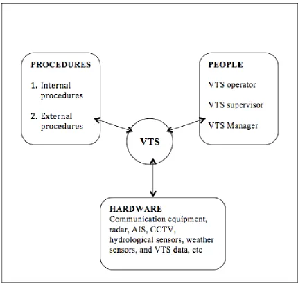
3.6 Essential Components of a VTS System
As mentioned in the previous sections, in the early days only VTS personnel and radars
formed the core of VTS’ but as time went on and new innovations and technologies
emerged, other information gathering and communication tools were added. According
to Kop (as cited in Ustaoglu and Furusho, 2014) the components of a basic VTS system
can be categorized into four parts namely hardware, staff, training and procedures. In
the same report Ustaoglu and Furusho also cited Wiersma et. al., that another
categorization group the components into three; people, hardware and procedures. The
three-component-model of people, hardware, and procedures is adopted in this study
because training needs of staff can be discussed under personnel category.
According to the (International Association of Marine Aids, 2013), the people
component, include VTS operators, supervisors, and managers. Operators work in VTS
centres controlling traffic in the port or on approach whilst supervisors supervises and
ensure that operations within a VTS centre conform to standards set by the VTS
authority. VTS Managers manages and coordinates the activities of the VTS centre or
centres on behalf of the VTS Authority. Training of VTS personnel is based on the
recommended format of IALA. Training course 103 contains detail recommendations
on training of VTS personnel. According to IALA, VTS Operators are trained by the
model course V-103/1 whilst Supervisors must have V-103/2. Apart from these, IALA
VTS). Personnel are expected to maintain certification by refresher training and
revalidation.
Sources: Created by the author, based on an integration of the VTS model proposed by
Wiersma et.al (as cited in Ustaoglu and Furusho, 2014) and VTS components described
in IALA VTS manual 2012.
The second component of the three-component-model is procedures. International
Association of Marine Aids (2011) noted that procedures should form an integral part of
a verifiable safety management system for the VTS. IALA recommends VTS
authorities to develop operational procedures because collection and dissemination of
information involves internal and external communications. Procedures for running a
VTS centre include the operation of systems and sensors, interactions among staff and
the internal data processing in routine and emergency cases are seen as internal
procedures. However, procedures that govern the interaction with participating vessels
are considered as external procedures.
The third component of the three-component-model is hardware. VTS hardware all
started with a simple radar but professors (Siousiouras and Dalaklis, 2009, p2) stated
that “new technologies and especially the further exploitation of Information and
Communication Technologies (ICTs) such as traffic management systems can provide
new and more comfortable services to passengers, increase safety and security and
reduce the associated with traffic environmental impacts.” VTS equipment today
comprises communication equipment, radar, AIS, CCTV, hydrological sensors, weather
sensors, and VTS data system. The uses of that are associated with a particular VTS
would determine what hardware is integrated. Perhaps in the case of modern VTS and
VTMIS, another important subcomponent under hardware is software. This is used to
manipulate and control the hardware give better meaning to the data received.
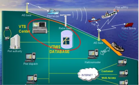
3.7 Vessel Traffic Management and Information Services/System (VTMIS)
A VTMIS extends beyond the components of a VTS with the addition of a MIS
element. VTMIS process data from VTS equipment and makes it available for
decision-making. The model in Figure 2, illustrates components of a basic VTMIS. Data from
sensors such as radars and AIS are fed into the VTS centre and such information is
database centre also pulls information from the VTS centre and process it. Port
authorities, Navy, Coast Guard department, SAR units, Maritime authorities, Policy
makers, etc can be served with the information to aid them in planning. VTMIS also can
be connected to Long Range Identification and Tracking System (LRIT) data centres for
collecting maritime security-related information (European Commission, 2006). This
system enables global identification and tracking of ships. LRIT communicates
information on the identity of the ship and its position and allow Flag States to track
ships under its flag everywhere in the world. The hardware component discussed under
VTS in VTMIS is integrated with software under VTMIS.
Source: Adopted from Shelter International, 2015
3.8 Definition of Maritime Security
According to Bueger (2014), today countries such as the United Kingdom (UK), United
States of America (US), and organizations such as the European Union (EU), African
Union, (AU), North Atlantic Treaty Organization (NATO), the MSC of IMO, all
include maritime security in their list of task. However, there is no agreed definition of
maritime security in the literature. Often, discussions loosely define it as the absence of
threats such as maritime inter-state disputes, maritime terrorism, piracy, arms
proliferation, illegal fishing, environmental crimes, or maritime accidents that prevail in
the maritime domain. This approach has not been satisfactory since it does neither
prioritize issues, nor provides clues of how these issues are interlinked, nor outlines
how these threats can be addressed, not to talk of the puzzles over which threats to add
to the list. The meanings attached to maritime security will always vary; to cope with
this multi vocabulary Bueger proposed three frameworks, by semiotics, securitization,
and security practice theory. Semiotics maps different meanings of maritime security by
exploring the relations between it and other concepts whist securitization framework
provides the means to understand how different threats are included in maritime
security. To Bueger, security practice theory takes a closer look at the actions that are
undertaken in the name of maritime security in trying to understand the concept.
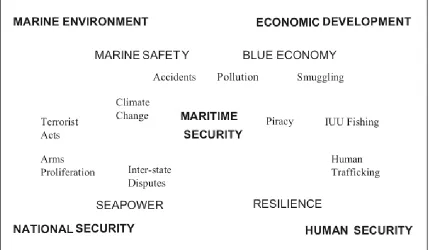
This study adopts one of Bueger’s proposed frameworks “semiotics” to help define and
understand the nature of maritime security in the GoG area. According to Bueger (2014,
p.160) “in semiotic thinking the meaning of a term can be grasped by exploring the relations of the term to others.” He further explained that in the case of maritime
security, at least four concepts require consideration: seapower, marine safety, blue
economy, and human resilience. A matrix of these four concepts and how they relate to
Source: Bueger, 2014, p.161
Figure 3: Maritime Security Matrix
Seapower include concepts such as a nation’s comprehensive power and maritime
strategy, advanced maritime technology, command of the sea, sea denial, and naval
power. It relates to maritime security in areas of national security in the maritime
domain and inter-state disputes. According to Bueger, firmly based in a traditionalist
understanding of national security as the protection of the survival of states, seapower
aims at laying out the role of state naval forces and at elaborating strategies for their use
in the maritime domain. Naval forces are one of the major actors in maritime security
and concerns have always been for state forces should act outside their territorial waters,
engage in other regions than their own and have a presence in international waters.
Fransas, Nieminen, Salokorpi, and Rytkonen (2012) defined maritime safety as “the
and limit the effect of accidental or natural danger, harms, damage to environment, risk
or loss.” According to Bueger (2014), maritime safety “in the first place implies the
regulation of the construction of vessels and maritime installations, the regular control
of their safety procedures as well as the education of maritime professionals in
complying with regulations.” Efforts at ensuring safety of ships and maritime
installations are aimed towards protecting maritime professionals and the marine
environment. According to Bueger, maritime safety concerns are core to maritime
security given that it may involve environmental and cultural interests. This is also
because the maritime industry is potential target of pirates, terrorists, trafficking of
persons, illicit goods, and weapons.
Shipping, fishing, and offshore resources such as crude oil play significant roles in
many economies today; coastal tourism is also important. Bueger (2014, p.161) argues
that the commercial value of oceans “blue-economy” has been re-evaluated because of
these contributions. Blue economy has seen significant endorsement in the world and
efforts have been made at “linking and integrating the different dimensions of the
economic development of the oceans and constructing sustainable management
strategies for these.”
Burger also supports that human security is the fourth concept necessary for
understanding maritime security. The United Nations Development Program (UNDP)
first proposed human security as an alternative concept for understanding national
security. Burger noted that “core dimensions of human security concern food, shelter, sustainable livelihoods and safe employment.” The sea is a major source of food,
livelihood, and employment to many in less developed countries. In effect Illegal,
Unreported and Unregulated (IUU) fishing is a major concern to human security. Issues
such as security of seafarers and vulnerability of coastal populations to maritime threats