INTERNATIONAL JOURNAL OF SCIENTIFIC & TECHNOLOGY RESEARCH VOLUME 6, ISSUE 10, OCTOBER 2017 ISSN 2277-8616
342
Sequence Stratigraphic Analysis of Well ―X2‖ in
the Niger Delta, South Eastern Nigeria
Ukpong, A. J., Ikediasor K.C., Ekhalialu O. M., Osung E. W.
ABSTRACT: Sequence stratigraphic analysis was carried out on well ―X2‖ (interval 2590m -3300m) in the Greater Ughelli Depobelt of the Niger Delta based on wireline logs and biostratigraphic data. Standard laboratory preparatory and analytical methods were employed during the study and the data sets generated were integrated to construct a high resolution sequence stratigraphic framework for the study well. Results of the analysis revealed two (2) 3rd order depositional sequences and three (3) Maximum Flooding Surfaces (MFS 1, 2, and 3) dated ?33.0ma, ?31.3ma, and ?24.3ma respectively. The sedimentary units (mostly sandstone and shale intercalations) penetrated by the study well form part of the Agbada Format ion of the Niger Delta and are of Early to Late Oligocene and younger ages. This age assignment is based on the co-occurrences of index foraminiferal taxa (Hopkinsina bononiensis, Spiroplectamminawrightii, Uvigerinella sparsicostata, Lenticulina grandis and Bolivina imperatrix) recovered from well ―X2‖. The study well consists of Highstand System Tracts (HST) and Transgressive System Tracts (TST) which are made up of aggradational, progradational and retrogradational facies sequences.
Keywords: Foraminifera, Sequence stratigraphy, Depobelt, Niger Delta, Oligocene. Greater Ughelli
————————————————————
1.
Introduction
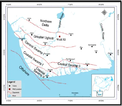
The Niger Delta is Africa‘s leading oil province [1] and is currently ranked among the prominent prolific deltaic hydrocarbon provinces in the world. It is the first to none in the West African continental margin in terms of hydrocarbon production [2] (fig 1) Sequence stratigraphic concepts have been largely applied to the Tertiary Niger Delta and have yielded impressive results in the siliciclastic successions in the Niger Delta petroleum province. It is currently regarded as an exceptional tool for exploration. The study of [1], [3],[4] attest to this. Sequence stratigraphic study in the Niger Delta was earlier undertaken by [4] who defined eleven (11) depositional sequences. The Niger Delta Cenozioc chronostratigraphic chart (fig 2) was also erected by [4] using eustatic sea level charts. This chart appears to be precise with high accuracy and contain information on Niger Delta‘s chronostratigraphy, marker shales, maximum flooding surfaces (MFS), sequence boundaries (SB), foraminiferal zonation (F-zone), pollen zonations (P-zone), Niger Delta Depobelts and its sequence stratigraphy.
Stacher (1995)[3] also produced a chronostratigraphic and sequence stratigraphic framework for the Niger Delta and [1] built on the studies of previous workers describing megasequences which contain regional transgressive claystone units (TST) followed by a range of heterogeneous fine-to-coarse progradational or aggradational silicicclastic parasequence sets formed during sea-level high-stand (HST). He also developed an updated biostratigraphic scheme for the Niger Delta as well as an updated sedimentation model that takes into consideration local and delta-wide effects of sea-level cyclicity and delta tectonics. In recent years, sequence stratigraphy has been applied in the Niger Delta by various workers such as [5], [6], [7], [8], [9], [10]. Sequence stratigraphy is a process-oriented approach to the interpretation of sedimentary packages bounded by unconformities and their correlative conformities [11]. It is based on the premise that sedimentary successions can be divided into unconformity-bounded units (sequences) that forms during a single, major cycle of sea level change. Sequence stratigraphy is basically a multi-disciplinary approach to the study of genetically related facies with chronostratigraphically significant surfaces [12]. It can be considered as integrated interpretation of data sets generated from different sub-discipline in earth science which include seismic
stratigraphy, biostratigraphy, well logging and
sedimentology. The study well (well ―X2‖) is an oil well in the Greater Ughelli Depobelt of the Niger delta (fig. 3). The Niger Delta is situated in the Gulf of Guinea and extends throughout the Niger Delta province as defined by [13] ___________________________
UKPONG, Aniediobong Jonah (Ph.D) is currently a
lecturer in the Department of Geology, Gombe State University, Gombe, Gombe State, Nigeria. andyukpong@yahoo.com.
IKEDIASOR, Kennedy Chidi is a master‟s degree
research scholar from the Department of Geology, University of Calabar, Calabar, Cross River State, Nigeria. Ikediasorkennedy@gmail.com.
EKHALIALU,Ogie Macaulay is a master‟s degree
research scholar from the Department of Geology, University of Calabar, Calabar, Cross River State,
Nigeria. ansmacaulay@gmail.com.
OSUNG, Wilson Edet is currently deputy chief
INTERNATIONAL JOURNAL OF SCIENTIFIC & TECHNOLOGY RESEARCH VOLUME 6, ISSUE 10, OCTOBER 2017 ISSN 2277-8616
345 Fig. 3: A map of Niger Delta Depobelt showing location of well “X2”.
2.
MATERIALS AND METHOD.
The materials utilized for this study include seventy one (71) ditch cutting samples (interval 2590-3300m) collected at ten meters (10m) interval from well ‗X2‘ and well log suites consisting of Gamma-Ray (GR) and Resistivity logs from the same well. Micropaleontologic, lithologic, and sequence stratigraphic analyses were carried out using laid out standard procedures. The standard approach for the processing of samples for foraminifera outline by [14], [15] were utilized in the preparation of samples from well "X2". The residues obtained after the extraction of foraminifera from the prepared samples were properly stored in well labeled sample bags for lithologic/sedimentologic analysis. Identification of the foraminifera extracted from the samples was done by comparing picked forms with previously published forms. Due to the problems of cave-in and missing intervals, only the top occurrences and acme of abundance was considered as tools of biostratigraphic importance in this study. Quantitative analysis of foraminifera was done using the number of species count per sample to establish diversity and abundance of forms. Lithologic analysis was done by examining the residues under the binocular microscope taking into consideration published lithofacies description of the Niger Delta as well as lithofacies model of [16], [17]. Sequence Stratigraphic study approach of [18] was adopted for the analysis of well "X2" (interval 2590m - 3300m).This was based on the combination of well logs (Gamma ray (GR) and Resistivity logs), lithologic descriptions (based on their sedimentologic
characteristics) and biostratigraphic data. The following procedures were followed.
I. Plotting of checklist, recording the detailed occurrence and abundance of planktic and benthic foraminifera. II. Plotting of lithostratigraphic column and erecting of
bio-zonations using foraminiferal index taxa based on First Appearance Datum (FAD) and Last Appearance Datum (LAD)
The identification and dating of primary horizon used in sequence stratigraphic analysis was attempted here. These include: The sequence Boundary (SB), Transgressive Surface (TS), and the Maximum Flooding Surface (MFS), which occurs within the condensed section in an area of low sediment accumulation rates and fauna floods. The dating of these key surfaces was achieved using the global cycle chart of [4] as well as the Niger Delta Cenozoic chronostratigraphic chart.
III. The determination of various system tracts; Lowstand System Tracts (LST), Transgressive System Tracts (TST) and Highstand System Tracts (HST).
IV. Preliminary definition of depositional sequences. V. Construction of a Sequence Stratigraphic Chart using
INTERNATIONAL JOURNAL OF SCIENTIFIC & TECHNOLOGY RESEARCH VOLUME 6, ISSUE 10, OCTOBER 2017 ISSN 2277-8616
346
3
RESULT AND DISCUSSION
3.1 Lithologic description of Well “X2”
A detailed lithologic description of seventy one (71) ditch cutting samples from Well ‗X2‘ (interval 2590m – 3300m) was carried out and the summary of the lithologic description is presented in table 1. It is important to note that intervals (2610m-2620m), (2630m-2640m),
(2650m-2660m), (2670m-2680m), (2850m-2860m),
(2980m-2990m), (3100m-3110m) were however missing in Well ―X2‖. The study well is characterized by fine-coarse grained, moderately sorted, sub angular to sub rounded, carbonaceous and ferruginized sands/sandstone with minor silt/siltstone and with intercalation of dark grey, sub fissile to fissile, hard to moderately hard, calcareous and micromicaceous shale.
Table 1: Depth and related lithofacies of sediments in Well „X2‟
Depth (m) Lithofacies Facies Lithostratigraphy
2590-2630 This facies is composed of sand unit with intercalations of siltstone. This facies is barren of foraminifera
A
A
G
B
A
D
A
F
O
R
M
A
T
IO
N
2630-2850 This facies is predominantly composed of shale. It is rich in foraminifera assemblage
B
2850-3250 This facies is composed of sandstone and shale in equal parts. This facies is poor in foraminifera assemblage
C
3250-3200 This facies is mainly composed of shale but little intercalations of sandstone and siltstone. This facies is rich in foraminifera
D
3200-3300 This facies is predominantly of sand/shale intercalation with a siltstone unit. It is basically devoid of foraminifera
E
3.2 Biostratigraphy of Well "X2"
In the well under study (―X2‖), the identification of Index foraminiferal taxa depended on previously published works by [19], [20], [21], [22], [23], [24], [25]. Micropaleontological (foraminiferal) analysis of Well "X2" revealed relatively high foraminiferal abundance throughout the well section except for some barren intervals especially at the upper section of the well (2940m-2970m) and towards the lower section of the well (3030m-3050m). Also recovered were some Ostracod and Shell fragments (fig 4). A total count of two thousand, three hundred and ninety three (2,393) foraminifera specimens were recovered during this study. Out of this number, two thousand, three hundred and seventy five (2,375) were benthic representing 98.91% of the total number of foraminiferal species while the planktonic foraminifera were 16 (sixteen) only constituting 0.66%. The total calcareous forams recorded were 2,094 representing 89.7% of the total number of foraminiferal species and the arenaceous forams were 272 representing only 11.36%. Index foraminiferal taxa recovered from well "X2" which were used in dating include Hopkinsina
bononiensis, Spiroplectamima wrightii, Uvigerinella
sparsicostata, Lenticulina grandis and Bolivina imperatix.
Hopkinsina bononiensis is an Early Oligicene - Miocene
foram [24]. This foram has an FDO of 2640m and an LDO of 3190m in Well "X2". This foram's LDO was used as an index marker for the Early Oligocene and its FDO was used as an index marker for the Late Oligocene. [26] used
Hopkinsina bononiensis to date the Oligocene Rapel Clay
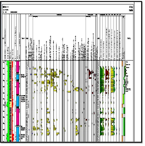
347 Fig. 4: Sequence stratigraphic chart of Well "X2"
Spiroplectammina wrightii is an Early Oligocene - Early
Miocene foram with an LDO of 3120m in well "X2" corresponding with the MFS dated 33.0ma. This foram's LDO was also used as an index marker for the Early Oligocene in Well "X2". Loeblich and Tappan (1988)[27] assigned a Lower Paleocene to Oligocene age to
Spiroplectammina wrightii, Uvigerinella sparisicostata is a
Middle Oligocene foram [28]. The top occurrence of this foram at 2800m is an indication of the penetration of Middle Oligocene age in well ―X2‖. This also corresponds to the MFS dated 31.31ma. Renz (1948)[28] dated the
Uvigerinella sparsicostata zone of the Aqua Salada Group,
State of Falcon, Venezuela as Middle Oligocene.
Lenticulina grandis is a Paleocene - Oligocene foram. The
influx of this foram at 2870m was used as an index marker for the Middle Oligocene. This corresponds to the MFS dated 31.3ma. Bolli and Saunders (1994) [29] designated the Middle/Late Oligocene boundary using Lenticulina
grandis. Cushman (1931) [30] also assigned a
Paleocene-Oligocene age to Lenticulina grandis. Bolivina imperatrix is an Oligocene - Middle Miocene foram [30]. Obiosio (2013) [31] used Bolivina imperatrix to date the Eocene-Oligocene of the Niger delta. Table 2 shows the foraminiferal events in well ‗‘X2‘‘. The FDO of Bolivina imperatrix was observed at 2700m and this gave credence to its use as an index marker for the Late Oligocene and younger ages in well ―
INTERNATIONAL JOURNAL OF SCIENTIFIC & TECHNOLOGY RESEARCH VOLUME 6, ISSUE 10, OCTOBER 2017 ISSN 2277-8616
348 Table 2: Key foraminifera events in well „X2”
3.3 Sequence stratigraphy of Well "X2"
According to Armentrout (1995) [32], the primary horizons used in sequence stratigraphic analysis are Sequence Boundaries (SB), Transgressive Surface of Erosion (TSE) and the Maximum Flooding Surface (MFS). Sequence Boundaries (SB) and the Maximum Flooding Surface (MFS)
were both identified in Well "X2". The dating of SB and MFS are tied to the Niger Delta stratigraphic commission charts and a summary of the system tracts and key surfaces is shown in table 3.
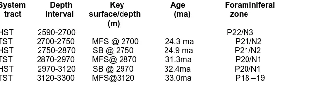
Table 3: Systems Tracts and key Surfaces with Corresponding Depths and Ages
System Depth Key Age Foraminiferal tract interval surface/depth (ma) zone (m)
HST 2590-2700 P22/N3 TST 2700-2750 MFS @ 2700 24.3 ma P21/N2 HST 2750-2870 SB @ 2750 24.9 ma P21/N2 TST 2870-2970 MFS@ 2870 31.3ma P20/N1 HST 2970-3120 SB @ 2970 32.4ma P20/N1 TST 3120-3300 MFS@3120 33.0ma P18 –19
The detailed descriptions of the major key bounding surfaces are as follows:
Sequence Boundary- Two sequence boundaries were identified in Well "X2", they are viz; the 32.4ma and the 24.9ma sequence boundaries. The summary of the recognized and identified Sequence Boundaries (SB) and the depth at which they occur in Well "X2" are shown in table 3. The 32.4ma sequence boundary in well "X2" occurred at 2973m while the 24.9ma sequence boundary occurred at 2750m. The oldest sequence boundary (SB1) identified in the well under investigation was dated 32.4ma. The surface represents an unconformable surface, probably a surface of erosion or non-deposition. It lies beneath the MFS2 dated 31.3ma. SB 1 is overlapped by a relatively thick and sharp based sand unit identified as Distributary / Inter-distributary Channel. The near cylindrical log shape shows slight left deflection and a corresponding right deflection resistivity log-signature. The 24.9ma sequence boundary (SB2) occurred at 2750m in the well "X2". The sequence boundary shows a kick on the gamma ray log indicative of a sand unit. This sand unit separates the shale units above and below. This Sequence boundary separates the high stand systems tracts below from the transgressive system tracts above. This thin sand unit representing the sequence boundary is probably as a result of a change in depositional conditions, since it has an unconformable surface. It also means that erosion probably took place.
Maximum Flooding Surface (MFS) - The MFS was identified as the shaliest part of the section with a high
gamma ray value and/low resistivity, with faunal maxima. Three MFSs were identified in well "X2‖, they are: The 33.0ma MFS 1 with LDO of Spiroplectammina wrightii at 3120m, the 31.3ma MFS 2 with top of Uvigerinella
sparsicostata and influx of Lenticulina grandis at 2870m
and finally the 24.3ma MFS 3 with FDO of Bolivina
imperatrix at 2700m. The summary of the recognized and
identified MFSs and the depths at which they occur in the well are shown in table 3. MFS 1 in the study well occurred at a depth of 3120m and was dated 33.0ma. It is the oldest MFS in well uX2‖. MFS 2 in well "X2" was dated 31.3ma at 2870m. The youngest Maximum Flooding Surface (MFS 3) at 2700m in well "X2‖ is dated 24.3ma and was marked by the FDO of Bolivina imperatrix.
System Tracts -A detailed description of the system tracts of Well "X2" (Table 3) is presented below. System tract; Transgressive System Tracts (TST). Interval: 3120m-3300m. This is the basal and oldest system tract of the well "X2". It consists of alternations of sand, shale and siltstone. The alternations are indicative of the variation in depositional energy. The parasequence consists of fining/deepening upward sequences which are evidences of high signature of the gamma ray log. The high resistivity signatures recorded at the sandy intervals may signify a possible hydrocarbon reservoir [33]. The sand units are intercalated with shale and considering the depth interval (3120m - 3300m), these sand units may constitute good reservoirs. The top of this systems tract has a condensed section with a peak at 3120m designated as MFS 1 (33.0ma). However, the base of this system tract was not S/N FORAMINIFERAL EVENTS
1. FDO of Hopkinsina bononiensis @ 2640m
2. FDO of Bolivina imperatrix @ 2700m
3. Top occurrences of Uvigerinella sparsicostata and influx of Lenticulina grandis @ 2870 4. LDO of Spiroplectammina wrightii @ 3120m
349 encountered at 3300m. Systems tract: Highstand System
Tracts (HST) Interval; 2970m - 3120m. The lithofacies within this interval consists of mainly shale with a simple sandstone unit (coarse). The log shows a cylindrical shape with an incursion at the sandstone unit at 3030m depth. The top of this interval is marked by a sequence boundary (SB1) dated 32.4ma and the base of this sequence is designated as MFS 1, which is the oldest MFS in the "X2" Well. System tract: Transgressive System Tracts (TST). Interval: 2870m – 2870m. This lithofacies is characterized by predominately sandstone with shale intercatations. The occurrence of this system tracts after a highstand system is only because of the depositional conditions which by passed a low stand system. The resistivity signature shows a mild kick while the gamma ray logs shows a high kick at the sand unit. The top of this system tract is marked by the MFS 2 dated 31.3ma. This system tracts has basically a progradation log signature. System tract: Highstand Systems Tracts (HST) Interval: 2750m - 2870m The lithofacies is characterized predominantly by shale with a sandstone unit occurring at the second sequence boundary (SB 2) marking the top of this unit. The abundance of taxa in this system is average, consisting of calcareous benthic and some arenaceous forms. The log signature is cylindrical with the only kick occurring at the sequence boundary overlying this shale unit. This top sequence boundary (SB 2) is dated 24.9ma and is marked by a sandstone unit. System tract: Transgressive System Tracts (TST) Interval: 2700m-2750m, This system tract is a small unit consisting basically of shale. The overall log signature is cylindrical with basically no major log kicks both on the gamma and resistivity logs. The signature from the log shows the aggrading parasequence. The system tracts is marked at the top by MFS 3, dated 24.3ma at 2700m and it is marked below by a sequence boundary (SB 2) dated 24.9ma. There
is a high abundance of agglutinated foram
(Spiroplectammima wrightii) in this Transgressive Systems
Tract. There is also a high abundance of the calcareous foraminifera (Buliminella aff. subfusiformis). System tract: Highstand System Tracts (HST) Interval: 2590m - 2700m This system tract consists basically of shale with intercalations of sandstone and siltstone. The gamma ray log shows a high kick while the resistivity log signature is cylindrical. The shale unit contains foraminifera, which includes both calcareous and agglutinated forms. The calcareous forams present include Buliminella aff.
subfusiformis, Hanzawaia concentrica and Hanzawaia
strattoni. The agglutinated forams include Spiroplectamina
wrightii and Haplophramoidessp. The gamma log shows a
progradational/retrogradational parasequence. The lower boundary of this highstand system tracts is marked by the MFS 3 dated 24.3ma but the top of this systems tract is not defined in this well "X2".
Depositional sequence- Well "X2" revealed two (2) depositional sequences. Sequence one (SQ 1) starts from MFS 1 dated 33.0ma at 2870m and terminates at 3120m which is about 250m. This depositional sequence consists of a Highstand System Tracts (HST) spanning an interval of 2970m-3120m and is capped by a Transgressive System Tracts (TST) of depth interval 2870m - 2970m. The MFS 2 dated 31.3ma terminates this sequence. Sequence two (SQ2) is younger than sequence 1 (SQ1) and spans 2700m
-2870m. It commenced with the deposition of a Highstand System Tracts (HST), which is then capped by a Transgressive System Tracts (TST). The Highstand System Tracts (HST) span 2750rn - 2870m and the Transgressive System Tracts (TST) span 2700m - 2750m. The Maximum Flooding Surface (MFS 3) at 2700m, dated 24.3ma terminates this sequence.
4. SUMMARY AND CONCLUSION
Sequence stratigraphic analysis of Well "X2" in the Niger delta revealed a sequence stratigraphic model that is composed of two sequence boundaries (SB1 and SB 2 at 32.4ma and 24.9ma respectively) and three maximum flooding surfaces (MFS, MFS 2 and MFS 3, at ?33.0ma, ?31.3ma and 24.3ma respectively). Six system tracts (consisting of three (3) transgressive systems tracts and three (3) highstand systems tracts) and two (2) depositional sequences were also delineated in the well "X2". The depositional model of sediments penetrated by Well "X2" (2590m - 3300m) was based on the delineated system tracts and consists of Highstand system tracts and the Transgressive system tract.
ACKNOWLEDGEMENTS
We wish to express our profound gratitude to the management of Nigerian National Petroleum Corporation (NNPC) and Nigerian Agip Oil Company (NAOC) for providing the ditch cuttings and wireline logs for this study. Many thanks to the Departments of Geology, University of Calabar, Calabar, Nigeria and Gombe State University, Gombe, Nigeria as well as South-Sea Petroleum Consultants, Port-Harcourt, Nigeria.
REFERENCES
[1] ReijersT.J.A. ‗‘Stratigraphy &sedimentology of the Niger Delta‘‘.Geologos, 17 (3): 133–162, 2011.
[2] Aizebeokhai A. P. & Olayinka I. ‗‘Structural &stratigraphic mapping of Emi field, offshore Niger Delta‘‘.Journal of Geology &Mining Research Vol. 3(2), pp. 25-38,2011.
[3] Stacher P,‗‘Present understanding of the Niger Delta hydrocarbon habitat‘‘, in M.N. Oti, &G. Postma, eds., GeologyofDeltas: Rotterdam, A.A. Balkema, p. 257-267,1995.
[4] Haq, B. V. Hardenbol, J. & Vail, P. R. ‗‘Mesozoic & Cenozoic chronostratigraphy&cycles of sea level change‘‘. In: Wilgus, C., Hastings, B. S., Kendall, C. G., Posamoentier, H. W., Ross, C. A. &Van Wagoner, J. C. (Eds), Sea level changes: An
integrated Approach, 42, SEPM special
publication, 42, 72-108,1988.
[5] Ozumba, M. B.‘‘ Middle to late Miocene sequence stratigraphy of western Niger Delta‘‘, Nigerian Association of petroleum explorationist Bulletin. 13 (2): 168-175. 1999.
INTERNATIONAL JOURNAL OF SCIENTIFIC & TECHNOLOGY RESEARCH VOLUME 6, ISSUE 10, OCTOBER 2017 ISSN 2277-8616
350 offshore, Niger Delta‘‘, Nigeria. Journal of mining
&Geology, 43 (1): 175-186, 2007.
[7] Nton, M. E. &Esan, T. B. ‗‘Sequence stratigraphy of Emi field, offshore, Eastern Niger Delta Nigeria‘‘. European Journal of scientific research vol. 44 (1): 115 – 132, 2010.
[8] Onyekuru, S. O., Ibelegbu, E. C., Iwuagwu, J. C. Essien, A. G. & Akaolisa C. ‗‘Sequence stratigraphic analysis of XB field, central swamp Depobelt, Nigeria Delta Basin, Southern Nigeria‘‘. International Journal of Geoscience, 3:237-257,2012.
[9] Anakwuba, E. K., Onwuemesi, A. G., Ajaigwa, N. E., Akpunonu, E. O. &Onuba, L. N. ‗‘Sequence stratigraphic approach in Hydrocarbon exploration of Diok field, Eastern Niger Delta‘‘, Natural &Applied Sciences journal, 9 (2), 2008.
[10] Rotimi, O. J. ‗‘Sequence stratigraphy within a
chronostratigraphic framework of
Ningnngfield,Niger Delta‘‘. RMZ-material &Geo-environmental, 57(4): 475 – 500,2010.
[11] Mitchum, R. M., Vail, P.R., &Thompson, S. ‗‘Part Two: The depositional Sequence as a Basic Unit for Stratigraphic Analysis‘‘. In ―Seismic
Stratigraphy- Application to Hydrocarbon
Exploration‖ (Payton, C.E., ed), pp. 53-62. Am. Assoc. Petrol. Geol.Mem. No. 2.1977.
[12] Van Wagoner, J. G., Mitchum Jr. R. M., Champion, K. M., &Rahmaman, V. D. ‗‘Siliclastic sequence stratigraphy in well logs core &outcrops: Concepts &focus‘‘. American Association of Petroleum Geologists.Methods in Exploration series, 7.Pp. 55.1990.
[13] Klett, T.R., Ahlbrandt, T.S., Schmoker, J.W. and Dolton, J.L..‗‘Ranking of the world‘s oil and gas provinces by known petroleum volumes‘‘. U.S. Geological Survey Open-file Report-97-463, CD-ROM. pp. 56 – 58,1997.
[14] Brasier, M.D., ‗‘Microfossils‘‘. Univ. Hull Press; Kingtons-upon-Hull, UK, 193.pp.1979.
[15] Armstrong H.A &Brasier M.D. ‗‘Microfossils,‖ Blackwell Publishing Ltd, Oxford, UK.Pp 274-275.2005.
[16] Weber, K. J. &Daukoru‗‘Petroleum Geology of the Niger Delta‘‘: 7th
world petroleum congress proceedings, Tokyo, (2), pp. 209-221.1975
[17] Whiteman A. J. ‗‘Nigeria; its petroleum geology, resources &potentials‘‘. (1) 176; (2) 238.Graham & Trotman. London. Uk.1982.
[18] Vail P.R. & Wornardt, W.W., ‗‘An Integrated Approach to exploration &development in the
1990s: Well log seismic Sequence stratigraphy Analysis‘‘, Trans of the 41st
Annual Convention of the Gulf coast Assoc. of Geological Societies, Houston, Texas, PP. 630-650. 1990.
[19] Okosun, E. A. &Liebau A. ‗‘Foraminiferal Biostratigraphy of Eastern Niger Delta, Nigeria‘‘. Nigerian Association of petroleum explorationists, 14 (2): 136-156.1999.
[20] Bolli, H. M. & Saunders, J. B. ‗‘Oligocene to Holocene low latitude planktic foraminifera, plankton stratigraphy‘‘, Bolli, H. M., Saunders, J. B. ad Perch – Nielsen, eds. Cambridge Earth science series, Cambridge University press, 165-262.1985.
[21] Obaje, S. O., Okosun, E. A. Olaschinde, P. I. &Udensi, E. ‗‘Biostratigraphy &paleoenvironmental analysis of xy – field, offshore western Niger Delta, Nigeria‘‘. Earth science &community,2010.
[22] Petters, S. W. ‗‘Foraminiferal Biofacies in the Nigerian Rift &continental margins Delta‘‘. In M. N. Oti&G. Patma (Eds). Geology of Deltas: A. A. Balkem publishers, Rotterdam,1995.
[23] Petters, S.W. ‗‘An Ancient Submarine Canyon in the Oligocene – Miocene of the Western Niger Delta‘‘. Sedimentology, 31:805-810,1984.
[24] Petters, S. W. ‗‘Central West African cretaceous – tertiary Benthic foraminifera &stratigraphy‘‘. Journal paleontographical, 179, pp. 1 – 104,1982.
[25] Petters, S. W. ‗‘Some late Tertiary foraminifera from parabe-1 well, Eastern Niger Delta‘‘. RevistaEspanolademicropaleontologia, 11 (1): 1190-133.1979.
[26] Brouwer, J., ‗‘Depositional environment of the Oligocene Rupel Clay in Well Grashock – 1, Peel region, Netherlands‘‘, Geol. Mijnb., 56, 1:25-30.1977.
[27] Loeblich R. A &Tappan H. L ‗‘Foraminifera genera and their classification‘‘. Van Nostrand Reinhold Co.1988.
[28] Renz, H. H. ‗‘Stratigraphy &Fauna of the Agua Salada Group, State of Falcon, Venezuela‘‘. ,Geological Society of America.1948.
[29] Bolli H. M. Beckmann, J. P and Saunders J. B ‗‘Benthic foraminiferal biostratigraphy of South
Caribbean region‘‘. Cambridge University
Press.1994.
351 [31] Obiosio,E.O..‘‘Biostratigraphy &Paleoenvironment
of Bolivina Fauna from Niger Delta, Nigeria‘‘. Earth Science Research, 2:80-92, 2013
[32] Armentrout, J. M. ‗‘High resolution sequence Biostratigraphy Examples from the Gulf of mexico, pli-pliestocene. Geological society special publication.104, 65-86,1995.
![Figure 1: Geological Map of the Niger Delta and surroundings [1]](https://thumb-us.123doks.com/thumbv2/123dok_us/8984032.1436443/2.612.69.545.59.601/figure-geological-map-niger-delta-surroundings.webp)
![Figure 2: Niger Delta Cenozoic chronostratigraphic chart [4]](https://thumb-us.123doks.com/thumbv2/123dok_us/8984032.1436443/3.612.65.504.62.664/figure-niger-delta-cenozoic-chronostratigraphic-chart.webp)