LandSpaCES: A Spatial Planning Tool for Land Consolidation
Demetris DEMETRIOU, Cyprus; John STILLWELL, United Kingdom; Linda SEE, United Kingdom
Keywords: land consolidation; land reallocation; spatial planning; design; evaluation
SUMMARY
Land fragmentation is a significant problem in many parts of the world which hinders rational agricultural development and rural sustainable development. Land consolidation is considered to be the most effective land management approach for solving the problem of land fragmentation. It involves the re-organisation of the land tenure structure through land reallocation (or readjustment) and the provision of appropriate infrastructure. Land reallocation is accepted to be the most significant, complex and time-consuming process within land consolidation. It is split into two main sub-processes: land redistribution and land partitioning. Land reallocation is currently not adequately supported by existing information systems such as Geographical Information Systems (GIS). Therefore, LACONISS, a LAnd CONsolidation Integrated Support System for planning and decision making, is currently under development. LandSpaCES (Land Spatial Consolidation Expert System) is the central sub-system of LACONISS integrating GIS, expert systems (ES) and multi-criteria decision methods (MCDM) and can be utilized as a standalone spatial planning tool for land consolidation. It consists of two modules: the ‘Design module’ that is able to generate alternative land redistributions under different scenarios; and the ‘Evaluation module’ for assessing these alternatives. This paper outlines the basic structure and methods incorporated into each of these modules.
The ‘Design module’ has been applied to a case study area in Cyprus and the results showed a high system performance in terms of replicating an independent solution derived previously by human experts and an impressive performance in terms of run time. The ‘Evaluation module’, whose main functionality has also been demonstrated using a case study in Cyprus, represents a powerful MCDM tool for the comprehensive evaluation of alternative land redistribution plans. LandSpaCES makes a valuable contribution to solving the land redistribution problem in terms of automation, effectiveness, equity, transparency and comprehensively evaluating alternative solutions. It has potential applicability as a spatial planning tool for land consolidation in many other countries once the relevant country-specific knowledge base and value functions have been developed.
1. INTRODUCTION
Land fragmentation involves a significant problem in many parts of the world that may prevent rational agricultural development and rural sustainable development more generally
(Van Dijk, 2003). In particular, land fragmentation is associated with the small size, irregular
shape and dispersion of parcels within a holding. In addition, in Cyprus, the lack of road access and disadvantageous legal rights such as shared ownerships and multi-ownerships, e.g. ownerships that belong to more than one landowner or ownership of trees growing on the land owned by someone else, are also common problems (Demetriou et al., 2011a). However, land consolidation is considered as the most effective land management approach for solving the problem of land fragmentation and it is popular in the EU and in many other countries around the world. Land consolidation involves the re-organisation of the land tenure structure, known as land reallocation (or land readjustment), and the provision of appropriate infrastructure (Thomas, 2006), depending on the specific aims of a project.
Land reallocation is split in this research into two main sub-processes: land redistribution and land partitioning. Land redistribution comprises the preparation of a preliminary plan to restructure parcels in terms of their number, ownership, size, land value and approximate location. It is based on legislation, the existing land tenure structure, rules of thumb and the experience of the planner. In particular, in Cyprus, it involves answering the following questions: Which landowners will take property in the new plan and which will not? What is the total area, number of parcels and value of the property that each landowner will receive in the new plan? What is the area, value and approximate location of each new parcel belonging to each landowner?
Land partitioning, on the other hand, involves the subdivision of land into smaller ‘sub-spaces’, i.e. land parcels. This is conventionally a trial-and-error process based on legislation, the existing land structure, empirical design criteria, constraints and rules of thumb. Thus, land redistribution identifies the number, size, land value, landowner and approximate location of the new parcels whereas land partitioning involves the final design of parcels in terms of size, shape and location. Both sub-processes involve an evaluation of alternative solutions to produce a near optimal land reallocation plan or one that satisfies a set of criteria. Land reallocation is accepted as the most significant, complex and time consuming process of land consolidation (Sonnenberg, 2002; Essadiki et al., 2003; Ayranci, 2007) which is associated with three main problems: the long duration of projects, the high operational costs and the conflicts between the stakeholders involved. Existing information systems such as GIS do not adequately support more complex spatial planning processes (Batty, 2008; Geertman and Stillwell, 2009) such as land reallocation so as to tackle or minimise these problems. In addition, existing research (e.g. Kik, 1990; Avci, 1998; Ayranci, 2007) addresses land redistribution as a mathematical/optimisation problem and thus produces results that are in most cases not realistic/applicable. Therefore, an innovative Integrated Planning and Decision Support System (IPDSS), is required for automating and comprehensively supporting the entire land reallocation process (Demetriou et al., 2011a). Such a system, called LACONISS (LAnd CONsolidation Integrated Support System for planning and decision making), is currently under development.
The framework for this new prototype system (Figure 1) is outlined in Demetriou et al. (2011b) and is based on Simon’s (1960) three-stage decision-making module of intelligence, design and choice. The context of each phase is represented by a critical question regarding land consolidation: Is there a need for applying land consolidation? What are the alternative land reallocation plans? Which alternative plan is the most beneficial? Each of these questions is addressed by a sub-system of LACONISS: LandFragmentS (Land Fragmentation System); LandSpaCES (Land Spatial Consolidation Expert System); and LandParcelS (Land Parcelling System), each of which is fully integrated within a GIS environment.
LACONISS (Land Consolidation Integrated Support System for planning and
decision making)
LandSpaCES
(Land Spatial Consolidation Expert System)
LandParcelS
(Land Parcelling System)
Design phase I
Land redistribution module (GIS+ES)
Choice phase I
Land redistribution evaluation module (GIS+MADM)
Design II & Choice II
Land partitioning module (GIS+ GAs+ MODM)
Alternative land
redistribution plans Final land reallocation plan
Best land redistribution plan
LandFragmentS (Land Fragmentation System)
Intelligence phase
Land Fragmentation module (GIS+MADM)
Figure 1: The operational framework of LACONISS (Demetriou et al., 2011b)
The first of these sub-systems represents the ‘Intelligence phase’ of the process and involves building a land fragmentation module to measure the extent of land fragmentation on a scale from 0 (worst) to 1 (least). The second contains: (i) a new land redistribution design module that employs an expert system (ES) (Turban, 1995; Jackson, 1999; Giarratano and Riley, 2005; Negnevitsky, 2005) to generate alternative land redistributions (‘Design phase I’); and (ii) a new land redistribution evaluation module that uses multi-attribute decision-making (MADM) methods (Malczewski, 1999; 2006) to evaluate alternative land redistributions and identify the one which is the most beneficial (‘Choice phase I’). LandSpaCES is the central sub-system since the outputs from this module are the key inputs to LandParcelS (the land partitioning module), the sub-system that creates the optimum set of boundaries (polygons) for the land parcels using a genetic algorithm (GA) (Goldberg, 1989; Openshaw and Openshaw, 1997; Padhy, 2005; Deb, 2008) with multi-objective decision-making (MODM) methods (Deb, 2008) (‘Design and Choice phase II’) to define the final parcels in terms of size, shape, land value and location.
Both modules of LandSpaCES, i.e. the Design and the Evaluation modules, have already been developed and outlined in Demetriou et al. (2010a, 2011b) and Demetriou et al. (2011c, 2011d), respectively. This paper presents the entire LandSpaCES system by summarizing issues regarding the design, development, evaluation, operation and application of the system.
2. THE SCOPE OF LandSpaCES
The aim of LandSpaCES is to support the land redistribution process involving the following five objectives:
- automate the process of land redistribution so as to generate a complete problem solution by answering the relevant questions noted earlier;
- be used as a decision support tool by generating alternative land redistributions;
- enhance the land redistribution process by structuring it in a systematic, standardised and transparent way using an appropriate model;
- considerably diminish the time needed by a human expert to carry out the land redistribution process; and
- be capable of evaluating a set of alternative land redistributions using multi-attribute decision-making (MADM) methods.
The first four objectives refer to the Design module and the fifth to the Evaluation module. It should be noted that LandSpaCES focuses on the land tenure structure changes via land consolidation and it cannot assess the consequent benefits in agriculture and hence to farmers
(e.g. regarding production, productivity, farmers’ income et cetera). For the latter, other
models are used that may be fed by the outputs from LandSpaCES. The results of LandSpaCES can be also used as inputs to the ex-ante evaluation of land consolidation projects based on EU requirements (European Commission, 2004) and the system may also be used as a trainee tool for new and expert land consolidation technicians to understand and analyse the reasoning process underpinning land redistribution.
3. LandSpaCES DESIGN MODULE
3.1 System design
An expert system (ES, also known as a knowledge based system, KBS) is a computer system that is able to represent and reason with knowledge, aimed at solving a specific well-defined problem domain that would ordinarily require human expertise (Turban, 1995; Jackson, 1999). A typical ES consists of three main components: the user interface, which is responsible for the communication between the system and the user; the knowledge base, which contains the knowledge about a problem domain usually in the form of IF-THEN rules; and the inference engine, which carries out the reasoning for reaching a solution based on facts. Facts are decision variables which are input by the user. The design of a KBS involves certain tasks other than those followed in conventional software systems. This differentiation is due to the knowledge component that is embedded in the former type of system. More specifically, conventional computer programs perform tasks using conventional decision-making logic which contains little knowledge other than the basic algorithm for solving that specific problem and the necessary boundary conditions. On the other hand, a
KBS collects together the small fragments of human know-how into a knowledge base, which is then used to reason through a problem, searching for a solution. This task, i.e. the design of a so-called ES, usually consists of the following steps: system definition (which has been defined in the previous section), knowledge acquisition, knowledge representation,
knowledge-base building and the definition of the inputs and outputs (Giarratano and Riley,
2005).
Knowledge was collected through the following sources: the principal author’s long personal involvement in land consolidation projects; informal discussions/interviews with expert land consolidation technicians; documentation, such as Land Consolidation Law, formal guidelines and instructions issued by the Land Consolidation Department (LCD) of Cyprus, legal advice, et cetera; and an analysis of the solution given by experts in the case study used in this research. The knowledge that actually comprises the decision-making process has been represented by utilizing decision trees. In particular, the problem has been split into seven sub-problems represented by separate decision trees. The main decision tree shown in Figure 2 ends in six different types or cases of land redistribution, where each case is further represented by a separate decision tree.
START
Does the property of a landowner exceed the min land
value and/or area limits set by the Committee?
Has the landowner “excepted” parcels? The landowner will not receive property and his/her property will be distributed to
other landowners.
No
No Allocate to the
landowner the “excepted” parcels in
the same location.
Yes
Has the landowner “excepted” parcels?
Yes
Allocate to the landowner the “excepted” parcel (s) in
the same location
No
Has the landowner enough land to receive other parcels?
Land distribution to the landowner finished
What is the max no. of parcels which may receive a
landowner ?
Only one parcel
Up to three parcels Up to two
parcels
Yes
Yes
No
How many parcels has the
landowner?
How many parcels has the
landowner? How many parcels has the
landowner?
1 Parcel
> 1 Parcel
2 Parcels
>2 Parcels
3 Parcels
>3 Parcels
Land redistribution case 1
Land redistribution case 2
Land redistribution case 6 Land redistribution case 5 Land redistribution case 4 Land redistribution case 3
Figure 2: The main decision tree for the Design module of LandSpacES (Demetriou et al., 2011b)
Based on these trees, 74 IF-THEN rules were constructed. There are 22 generic rules which relate to the main decision tree and determine the high level outcomes, i.e. whether a
landowner receives property in the new plan and, if relevant, the maximum number of parcels that can be allocated to each landowner. The six decision trees that correspond to the land distribution types (or cases) contain 38 rules and focus on the decisions specific to each land redistribution case, e.g. whether to create a new parcel or whether to move a new parcel to another location. The following exemplify a generic and a specific rule:
Generic rule
IF [The total area OR value of a landowner’s property < the minimum completion limits set by the Committee AND the examined parcel is not excluded from redistribution] THEN [The landowner will not receive any parcel in the new plan AND he/she will receive the land value of the property as pecuniary compensation AND the property will be available for distribution to other landowners]
Specific rule
IF [The area of the new parcel ≥ the minimum parcel area set by the Committee AND the
area of the new parcel < the minimum area set by the Law] THEN [Set the new area equal to the minimum limit set by the Law AND create the new parcel]
The final step in the design of an ES is defining the inputs and outputs to the system. This particular problem requires two kinds of inputs, i.e. spatial data and ‘facts’. The spatial data are cadastral layers and their attribute tables from a GIS as well as additional related database tables. Facts are eleven decision variables (F1 to F11) that are input by the user, which are used by the rules to infer new parameters or conclusions or actions. Changing the facts will result in alternative land redistribution solutions. The system outputs are a database table and a map and indicate: (i) those landowners taking property in the new plan and those that do not; (ii) the total area and land value of the property that each landowner receives in the new plan; (iii) the number of parcels that each landowner receives in the new plan; (iv) the area and land value of each new parcel; and (v) the approximate location (i.e. centroid) of each new parcel(s) belonging to a landowner.
3.2 System development
A literature review of ES development (e.g. Giarratano and Riley, 2005; Hicks, 2007) suggests that the easiest and most efficient way to develop an ES is to use a specialised tool (e.g. an expert system shell). However, these specialised tools are designed for the development of standalone ES applications and not hybrid systems, e.g. involving GIS. However, there is a lack of specialised ES development tools capable of easily integrating ES and GIS. Therefore, it was decided to use a conventional programming language in a GIS environment. Visual Basic and ArcObjects provide greater development flexibility even though the time taken to develop the system is extensive. In order to base this integration on robust theoretical foundations, the so-called ‘No-Inference Engine Theory’ (NIET) was followed.
NIET was proposed by Hicks (2007) although the concept has been employed by other researchers (e.g. Griffin and Lewis, 1989). The basic feature of NIET is that the knowledge base and inference engine are not kept separated as in conventional ES. In NIET, there is no inference engine and the reasoning (rule base) and process (inference engine) are combined into a single unit. This transforms the traditional inference engine into a procedural solution
involving a sequence of IF-THEN statements. Thus, the rules are ordered in a logical sequence during the development stage. In the situation where two or more rules have at least the first condition of their premise in common, the conflict is resolved by firing the rules with the greater number of conditions, so that they can be tested first. This conflict resolution strategy is commonly employed and is the default for most ES products. Another feature of NIET is that rules can be grouped into ‘rule clusters’ (capturing sub-problems) depending on the task.
Another innovation of this module is the introduction of a parcel priority index (PPI) that has a twofold purpose: First, it results in the ranking of all the parcels in a project and therefore defines the priority of a landowner-parcel pair in terms of allocating a parcel in a certain location or not so as to ensure equity and transparency of redistribution and; second, it is utilized for ranking the parcels of the holding of each landowner, thus defining location preferences for the landowner’s new parcels. In other words, the parcel of a landowner with the greatest PPI represents the first preference of the landowner in terms of allocation. However, it is acknowledged that it will not always be possible to satisfy the highest preferences of all landowners because land will not be available in some land blocks (an area enclosed by roads or other physical features or the external boundary of the study area). Thus, in such cases, there is conflict among the landowners’ preferences. This conflict is solved by employing the initial ranking of all parcels based on the overall PPI, which defines the priority of a landowner-parcel pair in the land redistribution process in terms of allocating a parcel in a certain location or not. The higher the PPI, the higher the priority; hence the higher possibility for a landowner to receive his property in the desired location(s).When the land redistribution process is in progress, not every parcel-landowner pair is ensured a location in the new plan (and they may be ‘displaced’ at any time during the process) until the land redistribution process has terminated. The formulas for calculation of the PPI are presented in Demetriou et al. (2010).
The user interface of the Design module is a toolbar within the ArcGIS environment which consists of five icons as shown in Figure 3.
Figure 3: The LandSpaCES Design module toolbar
Each icon launches a separate window with a title, text boxes and command buttons. The Input Data window is used to input the shapefiles and databases provided/created for the case study. The Input Facts window is used to input the problem’s basic facts (F1-F8). The Run Land Redistribution Model window is used to run the land redistribution model assuming that the previous windows have been used appropriately. The planner also has to define three facts (F9-F11), namely, two weights for the PPI calculation and a minimum area limit for the creation of a new parcel for those landowners who may receive more than one parcel. The Display Outputs/Decisions window presents the system results as two output database tables, the output map and the attribute table of the map. The System Evaluation window executes
various calculations used for system validation, i.e. the comparison of the results from the system and human experts.
3.3 System evaluation
The evaluation of an ES involves the processes of verification (building a system that functions correctly in terms of eliminating errors) and validation (building a system that operates as it should in terms of the quality of the decisions made) (O’Keefe et al., 1987). Although the Design module has been subjected to both processes, the focus here is on validation and therefore how well the system performs. In particular, system performance is measured by comparing the agreement between the automated decisions made by the system and those taken by the human experts. Although the decisions made by the human experts do not necessarily result in the optimal solution (due to the manual processing of vast amounts of information and a degree of subjectivity in the decision making), this is the standard way of evaluating ES since the aim of such a system is to emulate the human reasoning process utilised for solving a narrow problem domain. Nine evaluation criteria were used to evaluate system performance: the number of landowners who received property (C1); the number of common landowners who received property (C2); the number of landowners who received a ’completed’ parcel (C3); the number of common landowners who received a ‘completed’ parcel (C4); the total number of new parcels created (C5); the number of new parcels created per group of owners (C6); the number of new parcels received by each landowner (C7); the number of new parcels received by each landowner in common blocks (C8); and the number of new parcels received by each landowner in a common location (C9). These criteria cover the most important decisions made by the expert regarding the land redistribution plan.
The results shown in Figure 4 are very encouraging since the system reproduces the human expert decisions with an agreement of between 62.6 and 100% for the nine validation criteria. For criteria C1, C2, C4 and C5, the agreement is >98% or close to perfect. For criteria C3, C6, C7 and C8, the agreement is over 70%. The lower performance for these criteria is due to the current inability of the system to directly model certain kinds of information such as the actual landowners’ preferences and demands, and the pre-decisions of the planning team, which may have resulted in a decision that violates a relevant legislation provision (based on justification).
Furthermore, in terms of operational performance, i.e. efficiency, the system considerably outperforms the human experts in terms of the amount of time taken to complete the process. A small survey carried out on 10 expert land consolidation technicians showed that an individual expert needs about 30 working days to solve this particular land redistribution problem whilst the ‘Design module’ needed only 6 minutes, which is an impressive time reduction for this task. Overall, the results showed that the system performance compared to the human experts’ solution is very good, but further improvements could still be made by adding more rules to the knowledge base. In addition, in a further system enhancement, the direct incorporation of extra data (e.g. the actual landowners’ preferences, land use, the landowners’ personal data, i.e. residence, age, occupation, et cetera) needs to be considered. Finally, testing the system with more case studies may also provide more robust conclusions regarding its performance.
Once system validation was successful, the system was run with 10 different sets of facts to generate 10 alternative land redistributions, which involves producing 10 different patterns of land fragmentation. As noted earlier, the final output of the ‘Design module’ is a land redistribution map showing the centroids of the new parcels with their attributes (size, land value, ownership et cetera), which is then transferred into the land partitioning module to create the optimum sets of boundaries (polygons) for the land parcels around each centroid. Figure 5 shows an example of part of an output map for land block 14 (an area enclosed by roads or other physical elements or the external boundary of the study area) for alternatives 1, 6, 8 and 10.
Figure 5: Output maps focusing on land block 14 for alternatives1, 6, 8 and 10 (Demetriou et al., 2011b)
Alt-8 Alt-10
Alt-6 Alt-1
The numbers above each centroid indicate the Owner_ID (on the left) and the area of the new parcel (on the right). It is apparent that a different land redistribution pattern is produced for each alternative in a selected block. In particular, alternatives 1, 6, 8 and 10 generated 8, 11, 12 and 6 new parcels respectively with varying locations and size. A general picture derived from 10 scenarios is that changing the facts can generate quite different solutions. These results indicate that the system is reliable for generating various alternative land redistributions by using different sets of facts. Further details of different sets of facts, the interaction between the facts and the alternative land distributions can be found in Demetriou et al. (2011a, b).
4. LandSpaCES EVALUATION MODULE
4.1 Evaluation process
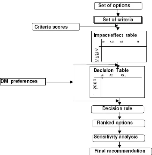
The Evaluation module aims to rank a set of alternatives generated by the Design module based on their performance in achieving land consolidation objectives, i.e. to minimise land fragmentation and the social and environmental impacts. The Evaluation module follows the classical MADM process (Figure 6) which is operationally carried out by a toolbar within the ArcGIS environment that it is shown in Figure 7.
Figure 7: The toolbar of the Evaluation module
Initially, the planner sets the evaluation criteria to assess these alternatives. Taking into account that a set of requirements (Malczewski, 1999; Sharifi et al., 2004) should be fulfilled by criteria, the following five evaluation criteria were refined, each with a corresponding attribute enclosed in parentheses: the size of holdings (mean size of new parcels - E1); the dispersion of holdings (mean parcel concentration coefficient, PCC - E2); the land exchange balance (change of the number of landowners - E3); the creation of landless people (percentage of ownerships ‘completed’ - E4); and the acceptance of the plan (mean landowners’ satisfaction rate, LSR - E5). A ‘completed’ ownership is an ownership with a unique parcel that has less area than that provided by legislation for the size of new parcels, thus it is ‘completed’ by adding more land to it in order to reach the minimum limit. Whilst E1, E3 and E4 are straightforward statistical parameters, PCC and LSR are more complicated evaluation criteria which were originally developed in the context of this research and are extensively discussed in Demetriou et al. (2011d).
An impact or effect table is constructed with alternatives in columns and criteria in rows. The performance of each alternative for each criterion is represented by a score, which is standardised using a linear transformation or value function approach to build the decision table. A value function approach has been used here because a linear transformation assumes a linear association between the original values and the standardisation values, which may not be true in practice, and it ignores the decision makers’ judgements regarding the definition of a particular strategy for a certain decision situation. Both of these limitations are overcome by the value function approach. Thus, a value function was constructed for each evaluation criterion by utilising the ‘direct value rating method’ (Beinat, 1997). An example of such a function is illustrated in Figure 8. This is a benefit value function because the greater the value (landowners’ satisfaction) the better it is. Thus, any score on the Y axis can be transformed into a standardised value between 0 and 1 on the X axis.
Weights for each criterion are then determined by the planner through a modified version of the rating method (Demetriou et al., 2011d) which was originally introduced in this research, using a seven point scale representing the importance of each criterion: extremely high, very high, high, intermediate, moderate, low and very low. Decision rules (Sharifi et al., 2004) representing a value/utility function approach (Beinat, 1997), are then utilised for ordering alternative land redistributions.
Thereafter, a sensitivity analysis (SA) is carried out by employing Triantaphyllou’s (1997) method to assess the robustness of the ranking order with regard to the weights of the evaluation criteria and the criterion scores (or performance measures), which are the most important elements (Triantaphyllou, 1997; Malczewski, 1999). Eventually, the best alternative is identified, which can then be passed onto the land partitioning module.
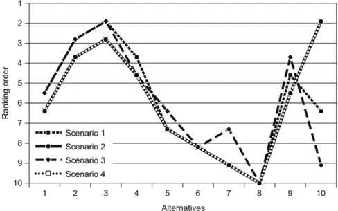
4.2 Ranking alternatives
Ranking the 10 alternatives generated in the Design module is carried out using four different scenarios that is, using a different combination of weights. Thus, in scenario 1, all five criteria have the same weight. In scenario 2, weights were assigned to each of the five criteria in the following descending order of importance: extremely high, very high, high, intermediate and moderate. In contrast, the weights in scenario 3 were assigned in ascending order of importance, whilst in scenario 4, they were assigned based on the judgment of the principal author as: extremely high, high, high, intermediate and very high, respectively. The results of the ranking are shown in Figure 9.
Figure 9: Ranking of alternatives for the four scenarios (Demetriou et al., 2011d)
Some interesting findings are as follows: no one alternative is best in all scenarios. In particular, alternatives 3 and 10 are ranked as best in scenarios 1, 3 and 2, 4 respectively. However, alternative 3 presents a more stable behaviour in all scenarios than alterative 10, because the former ranked second in both scenarios in which the latter ranked fist. In contrast, alternative 10 involves high unreliability because it is the only alternative that
presents so much difference in ranking positions (i.e. first, sixth and ninth) while all the other alternatives change at worst by two rank positions. As a result, alternative 3 can clearly be classified as the best alternative in the eye of an expert. Another important finding is that alternatives 2, 3, 4 and 9 (which are comparable in terms of facts with alternative 1 that represents the solution given by human experts in the case study) outperform alternative 1 under any one of the four scenarios. Thus, clearly the Design module may produce better solutions than those derived by experts. Moreover, a general finding is that the ranking of alternatives is very sensitive to the alteration of the weights of the criteria, which has also been found by Janssen and Rietveld (1985). Therefore, planners should be aware both of the weights assigned to each criterion and hence the weighting method utilised (Demetriou et al., 2011d).
5. CONCLUSIONS
This paper has presented LandSpaCES, a planning tool for land consolidation which has transformed the activity of land redistribution into a systematic, transparent and effective process compared to the way in which it is currently carried out, i.e. in a manual, slow, semi-computerised manner. In particular, the Design module has shown high system performance in terms of replicating an independent solution derived previously by human experts and an impressive performance in terms of run time. Moreover, the introduction of PPI ensures equity among landowners and the utilisation of rules for solving the problem ensures transparency and standardisation in the process. In addition, the successful integration of GIS with ES proved that the latter technology, despite its decline since the 1990s, is still valuable for solving complex spatial planning problems that involve decision making. Moreover, it has been demonstrated that NIET is an efficient alternative way for building an ES and fully integrating it within a GIS, despite some limitations that are a result of not using specific ES tools for development.
On the other hand, the Evaluation module represents a powerful new tool for the comprehensive evaluation of alternative land redistribution plans in terms of efficiency of the land tenure structure by incorporating expert judgement. Eventually, although LandSpaCES has some limitations that could be tackled, e.g. by adding more rules to the knowledge base or incorporating additional data into the model, it is a valuable contribution to solving the land redistribution process that has potential applicability to many other countries once the relevant country-specific knowledge base and value functions are developed. The outcome of LandSpaCES, i.e. the best solution, would now be passed onto the land partitioning module for the automatic generation of the new parcels in terms of shape, size, land value and location. The land partitioning (LandParcelS) module of LACONISS is currently under development.
REFERENCES
Avci M, 1998. A new approach oriented to new reallotment model based on block priority method in land consolidation. Tr. Journal of Agriculture and Forestry, 23: 451-457. Ayranci Y, 2007, Re-allocation aspects in land consolidation: A new model and its
Batty M, 2008. Planning Support Systems: progress, predictions, and speculations on the shape of things to come. In: Brail R., 2008. Planning Support Systems for Cities and Regions. Lincoln Institute of Land Policy, Cambridge, Massachusetts.
Beinat E, 1997. Value Functions for Environmental Management. Kluwer Academic Publishers, Dordrecht, The Netherlands.
Coelho C, Pinto A, Silva M, 2001. A systems approach for the estimation of the effects of land consolidation projects (LCPs): a model and its application. Agricultural Systems, 68: 179-195.
Crecente R, Alvarez C and Fra U, 2002. Economic, social and environmental impact of land consolidation in Galicia. Land Use Policy, 19: 135-147.
Deb K, 2001, Multi-objective Optimization Using Evolutionary Algorithms. Wiley, West Sussex, 1-46, 81-163, 447-478
Demetriou D, Stillwell J, See L, 2010a. LandSpaCES: A spatial expert system for land consolidation. Lecture Notes on Geoinformation and Cartography, Springer. Demetriou D, Stillwell J, See L, 2010b. LandSpaCES: A design module for land
consolidation: Methods and application. Working Paper 10/08. School of Geography, University of Leeds, Leeds. http://www.geog.leeds.ac.uk/research/wpapers.
Demetriou D, Stillwell J, See L, 2011a. Land consolidation in Cyprus: Why is an Integrated Planning and Decision Support System required? Land Use Policy 29:131-142 (in press for 2012).
Demetriou D, Stillwell J, See L, 2011b. An Integrated Planning and Decision Support System (IPDSS) for land consolidation: theoretical framework and application of the land
redistribution modules. Environment and Planning B: Planning and Design (in press). Demetriou D, Stillwell J, See L, 2011c. LandSpaCES: An evaluation module for land
consolidation: Methods and application. Working Paper 11/02. School of Geography, University of Leeds, Leeds. http://www.geog.leeds.ac.uk/research/wpapers.
Demetriou D, Stillwell J, See L, 2011d. A Spatial Multi-criteria Model for evaluating land consolidation plans. Journal of Multi-criteria Decision Analysis (submitted).
Eldrandaly K, 2003. A COM-based Spatial Decision Support System for Industrial site selection. Journal of Geographic Information and Decision Analysis, 7(2): 72-72 Eldrandaly K, 2007. Expert Systems, GIS, and Spatial Decision Making: Current Practices
and New Trends. In: Tyler, A., (eds.), Expert Systems: Research Trends. Nova, New York. Essadiki M, Ettarid M and Robert P, 2003. Optimisation of technical steps of a rural land
consolidation using a geographic information system: Land reallocation step. FIG working week, 2003, Paris, France.
European Commission, 2004. Guidance Note C: Ex-ante evaluation guidelines including SEA. Office for Officials Publications of the European Communities, Luxemburg. Geertman S and Stillwell J, 2009. Planning Support Systems: Best Practice and New
Methods. Springer, Dordrecht.
Geertman S and Stillwell, J, 2004. Planning support systems: an inventory of current practice, Computers, Environment and Urban Systems, 28(4), 291-310.
Giarrantano J and Riley G, 2005. Expert Systems: Principles and Programming. Course Technology, Canada.
Goldberg D, 1989. Genetic Algorithms: in Search, Optimisation and Machine Learning. Addison Wesley, Crawfordsville.
Griffin N, Lewis F, 1989. A rule-based inference engine which is optimal and VLSI implementable. Tools for Artificial Intelligence. Architectures, Languages and Algorithms. IEEE International Workshop, 23-25 Oct, pp 246-251
Hicks R, 2007. The no inference engine theory-Performing conflict resolution during development. Decision Support Systems, 43(2), 435-444.
Jackson P, 1999. Introduction to Expert Systems. Addison-Wesley, Third edition, Essex, 542pp.
Kik R, 1990. A method for reallotment research in land development projects in The Netherlands. Agricultural Systems, 33: 127-138.
Malczewski J, 1999. GIS and Multicriteria Decision Analysis. John Wiley & Sons, INC, New York.
Malczewski J, 2006. GIS-based multicriteria decision analysis: a survey of the literature. International Journal of Geographical information Science 20(7):703-726
Moore T, 2000. Geospatial Expert Systems. In: Openshaw S and Abrahart R (eds.), 2000. GeoComputation, Taylor & Francis, London and New York, 127-159.
Negnevitsky M, 2002. Artificial Intelligence: A Guide to Intelligent Systems. Addison Wesley, Second edition, Essex, 415pp.
O’ Keefe M, Balci O, Smith E, 1987. Validating expert system performance. IEEE Expert, 2(4), 81-89.
Openshaw S and Openshaw C, 1997. Artificial Intelligence in Geography. Wiley, West Sussex, 329 pp.
Padhy N, 2005. Artificial Intelligence and Intelligent Systems. Oxford University Press, New Delhi, 614 pp.
Rosman F and Sonnenberg J, 1998. New method for the design of the reallocation plan in land consolidation projects. Proceedings of the XXI FIG Congress, Brighton, UK. Sharifi A, Herwijnen M and Toorn W, 2004. Spatial Decision Support Systems. ITC,
International Institute for Geo-Information Science and Earth Observation, The Netherlands.
Simon H, 1960. The New Science of Management Decision. Harper & Row, New York. Sklenicka P, 2006. Applying evaluation criteria for the land consolidation effect to three
contrasting study areas in the Czech Republic. Land Use Policy, 23:502-510. Sonnenberg J, 2002. Fundamentals of Land consolidation as a Instrument to Abolish
Fragmentation of Agricultural Holdings. Proceedings of the XXII International FIG Congress, Washington, D.C., USA.
Stillwell J, Geertman S, Openshaw S, 1999. Geographical Information and Planning. Springer, Berlin.
Thomas J, 2006. What’s on Regarding Land Consolidation in Europe? Proceedings of the XXIII International FIG Congress, Munich, Germany.
Tourino J, Boullon M, Gonzalez X, 2003. A GIS-embedded system to support land consolidation plans in Galicia. International Journal of Geographical Information Science, 17 (4): 377-396.
Triantaphyllou E, 1997. A sensitivity analysis approach for some deterministic multi-criteria decision making methods. Decision Sciences 28(1): 151-194.
Turban E, 1995, Decision Support and Expert Systems. Prentice Hall, New Jersey, 887 pp. Van Dijk T, 2003, Dealing with Central European Land Fragmentation. Eburon, Delft. Zhu X and Healey R. 1992, Towards intelligent spatial decision support: integrating
BIOGRAPHICAL NOTES
Demetris Demetriou is the District Land Consolidation Officer for Larnaca and Famagusta in Cyprus. He holds a Diploma (Eng.) in Rural and Surveying Engineering from the Aristotle University of Thessaloniki (Greece). He also holds an MSc (Eng.) in Transport Planning and Engineering and an MSc in Geographical Information Systems; both from the University of Leeds (UK). His MSc dissertation titled “The development of a knowledge-based GIS to support land consolidation plans” has been awarded by the Regional Science Association International (British and Irish section) as the best taught postgraduate work in 2008. He is currently a PhD candidate in the School of Geography, University of Leeds (UK) working on “The development of an Integrated Planning and Decision Support System for land consolidation”. His main research interests are in land management, land consolidation, GIS, Planning Support Systems (PSS), Spatial Decision Support Systems (SDSS), Expert Systems (ES), Genetic Algorithms (GAs) and Multi-criteria decision methods (MCDM).
John Stillwell is Professor of Migration and Regional Development in the School of Geography at the University of Leeds (UK). Among his research interests are urban and regional planning, GIS and PSS. He is co-editor of the journal Applied Spatial Analysis and Policy and of several books about the use of GIS and modelling in planning, including, most recently, ‘Planning Support Systems Best Practice and New Methods’ (Springer, 2009).
Dr. Linda See is a Research Scholar at the International Institute for Applied Systems Analysis (IIASA) in Vienna (Austria) and Visiting Research Fellow in the School of Geography, University of Leeds (UK). Among her research interests are geographical information systems (GIS), artificial intelligence, and the application of soft computing methodologies including decision support and multicriteria evaluation. She is now working at IIASA on geo-wiki and land cover validation issues.
CONTACTS
Demetris Demetriou
School of Geography, University of Leeds Leeds LS2 9JT
Email:
Prof. John Stillwell
School of Geography, University of Leeds Leeds LS2 9JT
Email:
Dr. Linda See
Institute for Applied Systems Analysis (IIASA) Laxenburg, Austria