www.hydrol-earth-syst-sci.net/16/1667/2012/ doi:10.5194/hess-16-1667-2012
© Author(s) 2012. CC Attribution 3.0 License.
Earth System
Sciences
Parameterization and quantification of recharge in crystalline
fractured bedrocks in Galicia-Costa (NW Spain)
J. R. Raposo1, J. Molinero2, and J. Dafonte1
1Escola Polit´ecnica Superior, University of Santiago de Compostela, Campus Universitario s/n, 27002 Lugo, Spain 2Amphos XXI, Passeig de Garcia i Faria, 49–51, 1o-1a, 08019 Barcelona, Spain
Correspondence to: J. R. Raposo (juanramon.raposo@usc.es)
Received: 20 January 2012 – Published in Hydrol. Earth Syst. Sci. Discuss.: 13 February 2012 Revised: 18 May 2012 – Accepted: 22 May 2012 – Published: 15 June 2012
Abstract. Quantifying groundwater recharge in crystalline rocks presents great difficulties due to the high heterogene-ity of the underground medium (mainly, due to heterogeneheterogene-ity in fracture network, which determines hydraulic parameters of the bedrock like hydraulic conductivity or effective poros-ity). Traditionally these rocks have been considered to have very low permeability, and their groundwater resources have usually been neglected; however, they can be of local im-portance when the bedrock presents a net of well-developed fractures. The current European Water Framework Direc-tive requires an efficient management of all groundwater re-sources; this begins with a proper knowledge of the aquifer and accurate recharge estimation. In this study, an assessment of groundwater resources in the Spanish hydrologic district of Galicia-Costa, dominated by granitic and metasedimen-tary rocks, was carried out. A water-balance modeling ap-proach was used for estimating recharge rates in nine pilot catchments representatives of both geologic materials. These results were cross-validated with an independent technique, i.e. the chloride mass balance (CMB). A relation among groundwater recharge and annual precipitation according to two different logistic curves was found for both granites and metasedimentary rocks, thus allowing the parameterization of recharge by means of only a few hydrogeological param-eters. Total groundwater resources in Galicia-Costa were es-timated to be 4427 hm3yr−1. An analysis of spatial and tem-poral variability of recharge was also carried out.
1 Introduction
Groundwater is an important source of potable drinking wa-ter. Worldwide 50 % of the municipal water supplies come from groundwater. In general, groundwater is particularly important as a source of drinking water for rural and dis-persed populations (Forn´es et al., 2005).
including groundwater resources. Quantification of the rate of groundwater recharge is a basic prerequisite for efficient groundwater resource management. However, the rate of aquifer recharge is one of the most difficult components to measure when evaluating ground water resources (Sopho-cleous, 1991). For this reason, the development of new river basin management plans in accordance with the requirements of the WFD is a challenge for European water agencies.
The hydrologic district of Galicia-Costa is one of the 16 districts in which the Spanish Water Administration is di-vided. It covers all the watersheds completely located in-side the Autonomous Region of Galicia (NW of Spain). In this district more than one quarter of the total population use groundwater resources through private water supply facili-ties, especially in the rural areas (Romay and Ga˜nete, 2007). This use of groundwater occurs on the fringes of the pub-lic water supply by means of individual or communal private wells and spring water collecting. According to the Span-ish Geologic Survey (IGME), there are more than 300 000 wells in Galicia (Navarro Alvargonz´alez et al., 1993). All of these groundwater abstractions contrast with the mini-mal knowledge and study of the groundwater in Galicia. The granitic and metamorphic rocks that dominate the area of Galicia-Costa have traditionally been considered almost im-pervious or to have very low permeability, and their ground-water resources have usually been neglected in planning and water management. However, groundwater can become an important and volumetrically significant water store when the weathering and fracturing of the bedrock develop shal-low aquifers (Neal and Kirchner, 2000). Several studies us-ing various methodologies (water balance, chloride mass bal-ance, flow hydrograph decomposition) in Northern Portugal (a region geologically and climatically similar to Galicia-Costa) estimate the groundwater recharge range to be 5 % to 31 % of precipitation (Alenco˜ao et al., 2000; Lima and Silva, 1995; Martins Carbalho et al., 2000; Pereira, 2000). The few studies carried out in Galicia show that although the groundwater recharge rate is low, it is not negligible, espe-cially taking into account the high precipitation rate in this re-gion (900–2500 mm yr−1). In a site study on granitic terrains the recharge was estimated to be 8.8 % of the annual pre-cipitation using a water balance model (Samper et al., 1997, 1999; Soriano and Samper, 2000). Using the same method-ology, Raposo et al. (2010) estimates an average recharge at 13.6 % of annual precipitation in five granitic catchments in Galicia-Costa. This wide range of recharge rates makes it dif-ficult to carry out a regional characterization and quantifica-tion of groundwater resources. A new approach is needed to propose a regional recharge rate, different from the classical linear relationship of recharge-precipitation.
Besides in the neighboring North Portugal, aquifers with similar characteristics to Galician ones (developed on frac-tured crystalline bedrocks) are relatively frequent in Atlantic Europe: they are found in the Armorican and Central Mas-sifs of France, Scotland, Wales and Cornwall (UK), Ireland
and Scandinavia, (Environment Agency, 2005; Wendland et al., 2008; Knutsson, 2008; Robins, 2009; Banks et al., 2010). These regions are generally characterized by high precipita-tion, temperate-cold climatic conditions and a traditional use of shallow groundwater.
Recharge rate estimations in crystalline rock areas in Brit-tany, Scotland, Wales and the Channel Islands range between 15.4 % and 40 % of the precipitation (Robins and Smedley, 1998; Robins and Misstear, 2000; McCartney and Houghton-Carr, 1998; Robins et al., 2002; Church, 2004; Rouxel et al., 2011). Estimations in the Bohemian Massif are more than 20% of the mean annual precipitation (Kr´asn´y, 2002).
Crystalline rock aquifers are also exploited widely in tropical climates (Africa and India). There, however, the hydrogeological conditions are very different. These rocks are deeply weathered and rainfall recharge may be scarce. Granitic-gneissic complexes in southern India have a nat-ural recharge rate of 3–15 % of precipitation, partially be-cause of the adverse hydrometeorological factors (Sukhija et al., 1996; Massuel et al., 2007). Similarly, estimations of groundwater recharge of shallow aquifer on crystalline rocks in West Africa are 5–12 % of precipitation (Martin and van de Giesen, 2005; Fou´ep´e Takounjou et al., 2010).
An accurate characterization of aquifer recharge is crucial for efficient groundwater resource management. In addition, recent droughts in Galicia have highlighted the vulnerabil-ity of Galician groundwater resources due to variations in recharge, and have also emphasized the need for reliable es-timates of groundwater recharge. The first attempt of a global estimation of groundwater resources in Galicia (Xunta de Galicia, 1991) established a criterion based on theoretical in-filtration indexes for different terrains. The total renewable resources were estimated at 2000 hm3yr−1for all of Galicia.
Using the hydrological model SIMPA, Estrela et al. (1999) elevated this estimation to 2234 hm3yr−1 in Galicia-Costa only, which represents an average groundwater recharge of 18 % of precipitation. The last study on this topic (Xunta de Galicia, 2011) highlighted the large uncertainty in the pro-cess of recharge quantification in Galicia-Costa due to the high heterogeneity of the medium, and used three different methodologies to estimate the renewable resources to be be-tween a range of 3023 and 3689 hm3yr−1.
quantification and a more comprehensive study to take this variability into account.
Groundwater recharge can be quantified by different meth-ods addressed at different hydrological zones to evaluate dif-ferent timing of recharge, from potential values in the soil to some-delayed and smoothed net estimates in the satu-rated zone. Some approaches for recharge calculation are the water-table fluctuation method, seepage meters, lysimeters, isotopes, chloride mass balance (CMB) and different mod-eling approaches. Each technique has advantages and disad-vantages, and choosing the appropriate method for a partic-ular site and study is often difficult. Selection must be made based on different considerations: space/time scale factors, range, and the reliability of recharge estimates based on dif-ferent techniques (Scanlon et al., 2002). Uncertainties in each approach to estimating recharge underscore the need for the application of multiple techniques to increase the reliability of recharge estimates (Scanlon et al., 2002). Ideally, as many different approaches as possible should be used to estimate recharge.
In this study, two independent methodologies were ap-plied. Firstly, a hydrological model, based on water-table fluctuations and water-budget calculations using both surface-water and groundwater inputs, was used to estimate groundwater recharge to shallow aquifers. This hydrological model was applied to 9 small-size catchments ranged from 0.23 to 26.26 km2representatives of the main geologies and climates existing in the Galicia-Costa district. Subsequently, a tracer technique (CMB) was used in order to cross-validate the results obtained by the principal methodology. The re-sults obtained for these pilot catchments were finally extrap-olated to the whole district by means of a GIS tool to assess the groundwater in Galicia-Costa. Extrapolation was carried out according to geological and climatic criteria.
Both water balance models and CMB are proper meth-ods for a watershed or regional approach (Flint et al., 2002). While CMB presents the advantage of being a simple con-cept with few parameters needed, it also has several limita-tions such as assumplimita-tions not completely valid for fractured rocks or the high variability of Cl−deposition rate with time; these limitations increase the uncertainties of its results, for this reason CMB results are used only to compare with wa-ter balance model results. In contrast, limitations of wawa-ter balance models, as equivalence of shallow infiltration and recharge (Flint et al., 2002), can be easily assumed for shal-low aquifers present on fractured bedrock, while strengths as spatial and temporal distributions of recharge are desirable capabilities of the modeling approach. Furthermore, where land uses and soil types are relatively uniform and limited data determines the choice of model, simple models pro-vide a reasonable basis for long-term recharge estimates at the catchment scale compared to complex distributed models (Bradford et al., 2002).
There are two major objectives in this study: first to quan-tify groundwater recharge in the two main geologies present
in Galicia-Costa (granites and metasedimentary rocks) by us-ing two different techniques, their comparison and the sen-sitivity and uncertainty analysis of the estimates; secondly, to globally assess the groundwater resources in Galicia-Costa by means of parameterization of recharge and its GIS-supported extrapolation as well as the analysis of the spatial and temporal variability of the resource.
2 Description of the study area
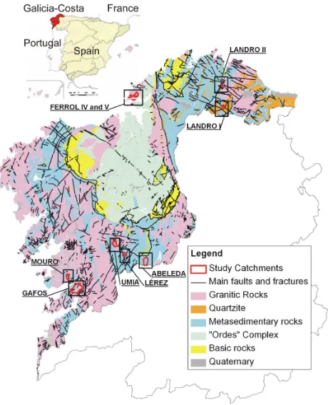
The Galicia-Costa hydrologic district is located on the North West coast of Spain (Fig. 1). It contains all of the watersheds entirely located inside the Autonomous Region of Galicia and extends over 13 072 km2, where more than 2 000 000 people are settled. This means 44 % of the Galician terri-tory and 75 % of its population. Due to the existence of many small aquifers developed on fractured and weathered bedrock throughout the district and the difficulty of individually char-acterizing each separate aquifer, an aggregate approach was required for the study of the Galician hydrogeology. Accord-ingly, the whole territory was considered as a continuous groundwater body that must be protected. For a management purpose, the Galician Water Administration (Augas de Gali-cia) defined 18 groundwater bodies following geographic and topographic criteria rather than geologic criteria. The bound-aries of each groundwater body coincide with the linked river watershed (Xunta de Galicia, 2003). These groundwater bod-ies really are the sum of a number of small disconnected aquifers.
The main sources of the high recharge heterogeneity ex-isting in Galicia-Costa are the different geology, the bedrock fracturing degree and the hydroclimatological conditions.
From a geological standpoint, Galicia-Costa can be di-vided into two main blocks (IGME, 2004): granitic rocks occupy approximately 38 % of the area, and metamorphic rocks (mainly slates, schist and gneisses) occupy 54 % of the total area (the remaining area corresponds to water bod-ies, quaternary deposits and a minimal area of limestone). Both groups of rocks have traditionally been considered to have very low permeability. However, they are frequently highly fractured and weathered, thus allowing the storage of a considerable volume of water in the secondary porosity. As shown in Fig. 1, the bedrock presents a vast net of faults and fractures. Some areas are especially fractured (e.g. northern quartzites), while other rock units are basically fresh (e.g. the Ordes Complex in central Galicia).
Fig. 1. Location of the hydrologic district of Galicia-Costa in the Spanish hydraulic division, the study catchments and geological map (elaborated from GEODE geological map; IGME, 2004).
varies significantly from site to site depending on the tec-tonic history of the rock. In a granitic site, Molinero Huguet et al. (1998) limit the rock with a high density of fractures to a depth of lower than 50 m, whereas geophysical surveys in a schistose site reported depths of fractured rock within a range of 30 to 100 m (Dafonte and Raposo, 2009).
From the coast line to the mountainous inland in Galicia-Costa (Galician Dorsal) there is also a high gradient of temperatures, evapotranspiration and precipitation (900– 2500 mm yr−1). Because the Galician aquifers are highly rain-recharge dependent and the residence time of the wa-ter in these aquifers is very short (Soriano and Samper, 2000; Samper, 2003; Raposo et al., 2010), climate conditions are relevant in the determination of the amount of recharge.
Land cover in Galicia-Costa is characterized by forest and grassland mixed mosaics, with scattered small cultivation plots. Agriculture is mainly rain fed, therefore effects of irri-gation on recharge can be neglected.
In order to characterize the aquifers in Galicia-Costa, nine lumped hydrological models were performed in small-size basins (0.23–26.26 km2). The different lumped models cover granitic, quartzite and metasedimentary rocks, in both coastal and inland areas, thus the different recharge rates in each con-dition can be analyzed.
3 Hydrological model
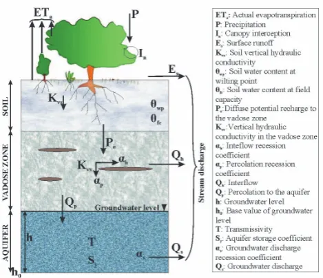
Visual Balan v2.0 (Samper et al., 2005) is a water balance model for the simultaneous modeling of daily water balances in the soil, in the unsaturated zone and in the aquifer that takes into account the main processes of water flow in under-ground media. Parameter optimization is conducted by cal-ibrating against multiple targets, such as groundwater levels and stream flow rates. Inclusion of both surface water and groundwater as input data provides a framework that can be used to check continuity and better constrain model param-eters and thus provides more reliable results than obtained only from surface-water data.
Visual Balan v2.0 is a lumped model and provides a single recharge estimate for the entire catchment, thus it can only be applied to small catchments and requires upscaling in or-der to cover an entire hydrologic district. On the other hand, small-scale applications allow more precise methods to be used to measure or estimate individual parameters of the wa-ter balance equation (Healy et al., 1989).
Visual Balan has proven reliable and robust when re-producing measured values of prolonged monitoring tasks that were carried out in several catchments of NW Spain (Mart´ınez et al., 2006; Raposo et al., 2010; Samper et al., 1997, 1999; Sena and Molinero, 2009; Soriano and Samper, 2000), and for recharge evaluation in other regions of Spain and Latin America (Candela et al., 2009; Carrica, 2004; Casta˜neda and Garc´ıa-Vera, 2008; Espinha-Marques et al., 2011; Garcia-Santos and Marzol; 2005; Jim´enez-Mart´ınez et al., 2010; Samper and Pisani, 2009; Weinzettel et al., 2002). This model presents the advantages of using data that can be easily measured or estimated with reasonable accu-racy (Jim´enez-Mart´ınez et al., 2010). Unknown parameters are calibrated by comparing computed stream flows and/or piezometric heads to measured data. The main input vari-ables are daily temperature, precipitation, wind velocity, sun-shine duration, relative humidity, and underground media pa-rameters (i.e., soil thickness, porosity, field capacity, wilt-ing point, hydraulic conductivity, curve number and reces-sion and storage coefficients). The outputs of the model are the water balance components (runoff, interflow, vegetal in-terception, ETaand groundwater recharge) and the modeled
groundwater levels and/or stream discharge rates.
Fig. 2. Main components of water balance considered under the framework of the computer program Visual Balan (Samper et al., 2005).
3.1 Soil water balance component The water balance in soil is represented by
P+Ir−In−Es−ETa−Pe=1θ (1)
whereP represents precipitation,Iris irrigation,Inis canopy
interception,Es is runoff, ETa represents the actual
evapo-transpiration,Peis potential recharge to the vadose zone and
1θis the variation of soil water storage. Each component is expressed as cumulative water volume per surface unit dur-ing a time interval1t (in this study1t equals one day, and the unit is mm). Because there are no significant irrigated areas, the present study considered daily precipitation as the only inflow of water in the balance. Further, this approach as-sumes a sequential model simulation for interception, runoff, evapotranspiration and the recharge process.
Canopy interception (In) is the fraction of precipitation
intercepted by vegetation (e.g. leaves, branches, stems and trunks). It was derived from Horton’s (1919) empirical for-mula that describes a linear relationship between intercepted volume (In)and total precipitation on vegetation (Pd)in a
rainfall event:
In=Sd+γ×Pd if Pd>
Sd
1−γ
In=Pd if Pd≤
Sd
1−γ (2)
whereSd andγ are empirical parameters related to the type
of vegetation and plant height.
The surface runoff estimation (Es) is derived from the
curve number method (Soil Conservation Service, 1986),
which is based on the relations between water losses and precipitation. Before runoff occurs, a precipitation threshold (Po)due to interception, infiltration and superficial storage
reduces the precipitation available for runoff toP−Po.Po
can be empirically obtained as a function of tabulated values of curve number andEsis calculated according to
Es=
(P−Po)2
P+4Po
(3) Potential evapotranspiration (ETP) can be calculated by the hydrological model using different methods. The FAO Penman-Monteith method (Allen et al., 1998) was chosen for this study because it is the method which provides the most reliable estimations in all regions and climates. A rel-evant step for recharge estimation is an accurate determina-tion of actual evapotranspiradetermina-tion (ETa), since it can be
sig-nificantly below ETP for long periods of time during the dry season. The Penman-Grindley method (Samper et al., 2005) was used to relate ETawith ETP. The relation varies
depend-ing on whether the soil water deficit (θswd)is higher than a
threshold value (CRPG):
ETa=W+CEPG×(ETP−W ) if θswd>CRPG
ETa=ETP if θswd<CRPG (4)
In the above equation,W represents the input water (avail-able water),θswd=θfc−θ, whereθfcis the soil water content
at field capacity andθthe current soil-water content, CEPG is a factor between 0 and 1, and CRPG constitutes the hydric deficit limit value and ranges between 0 and field capacity minus soil water content at wilting point (θfc−θwp). All
pa-rameters are expressed as equivalent height of water (mm) during a time interval1t.
The diffuse potential recharge to the vadose zone (Pe)was
computed by the following logistic function (Samper et al., 2005). It assumes that the soil is homogeneous and isotropic and that there is no direct recharge through soil cracks and preferential flow pathways:
Pe=
Kvs
1+βe−θα
(5)
where Kvs is the soil vertical hydraulic conductivity in
mm day−1, given thatα= (8s−θfc)/4 andβ=e(2+ θfc
α). 3.2 Vadose zone water balance component
Potential recharge (Pe)constitutes the only entry of water to
the vadose zone from the edaphic soil zone, while outputs of water can occur horizontally as interflow (Qh)and vertically
as percolation to the aquifer (Qp), according to the following
expressions:
Qp=Kvv+αp×Vh (7)
whereVhis the water volume stored in the vadose zone (in
mm),Kvvis the vertical hydraulic conductivity in the vadose
zone (in mm day−1),αhandαpare recession coefficients for
interflow and percolation (in day−1). Conceptually, interflow is related to the presence of perched aquifers in the vadose zone andαh depends on the average terrain slope, the
dis-tance traveled by the interflow along the hillside, the hori-zontal hydraulic conductivity and the drainable porosity in the vadose zone;αpis related with the distance between the
perched level and the regional groundwater level, the verti-cal hydraulic conductivity and the drainable porosity in the vadose zone. An explicit scheme (Samper et al., 2005) was applied for solving water balance in the vadose zone. 3.3 Aquifer water balance component
As Visual Balan is a lumped model, water balance in the aquifer was solved by considering each catchment as a single cell, where water inputs and outputs determine the oscilla-tion of the groundwater level at each1t. This simplification can be assumed by taking into account the small size of pi-lot catchments considered in this study. The only entry of water to the aquifer from the vadose zone (that links both underground media) is the vertical percolation (Qp), while
groundwater discharge (Qs)represent the only output. The
aquifer balance Eq. (8) relates these inputs and outputs with the variation of the stored water volume (1Va):
(Qp−Qs)1t=1Va (8)
The greater the water volume stored in the aquifer, the greater the groundwater discharge is, proportionally to a discharge recession coefficient (αs):
Qs=αs×1Va (9)
The water volume in the aquifer (Va)and the groundwater
level (h) are referred to as a base value (ho), which
corre-sponds to a volumeVao. The water volume stored over the
base value,1Va= (Va−Vao), is related to the change of level
1h= (h−ho)through the storage coefficient of the aquifer
(Sy):
1Va=Sy×1h (10)
The model calculates on a daily basis the water level and the water stored volume in the aquifer; this allows a comparison between measured and simulated groundwater levels. Simi-larly, daily measured discharges in streams can be compared to those calculated by the model as the sum of surface runoff (Es), interflow (Qh)and groundwater discharge (Qs).
4 Chloride Mass Balance (CMB)
The climatic component in groundwater chemical composi-tion (Custodio, 1997; Murphy et al., 1996) is a funccomposi-tion of the average chemical composition of precipitation. An accurate knowledge of this component allows explaining the presence of some ions in the groundwater and also can be used to esti-mate the average groundwater recharge by means of the mass balance of chemical components with a rainfall origin (Alli-son and Hughes, 1983; Rosenthal, 1987).
The chloride ion (Cl−)is ideal to perform chemical bal-ances because it remains inert during the recharge process (there is no significant long-term exchange with the environ-ment) and, unlike water, it remains in the soil after evapo-transpiration processes. It is also highly soluble and usually has a known marine origin. This technique was widely used, both in the vadose zone and in the saturated-zone (Cook and B¨ohlke, 2000; Eriksson and Khunakasem, 1969; Sami and Hughes, 1996; Wood and Sanford, 1995). This study uses the CMB approach to evaluate the direct rainfall recharge, using sampling from the saturated-zone. The CMB approach spatially integrates recharge over areas upgradient from the measurement point. However, problems with extrapolating point-source data to determine spatial variability of recharge remain. For that reason the specific results obtained by this technique will be mainly used for comparison with the hy-drological model results.
The mass of Cl−deposition into the system is the sum of wet deposition dissolved with precipitation and dry fallout, while runoff and groundwater recharge constitute the system outputs:
P×Cp=R×Caq+I×Ci (11) where R is the average net recharge (mm yr−1); P repre-sents average annual precipitation (mm yr−1); I is the erage runoff (overland and interflow); Cp is the effective av-erage Cl−concentration in precipitation (mg l−1), including the contribution from dry fallout; Caq is the measured Cl− concentration in groundwater (mg l−1); and Ciis the average Cl−concentration in runoff and interflow (mg l−1).
A zero surface runoff assumption is usually made for arid and semiarid climates, which simplifies the Eq. (11). How-ever, although substantial surface runoff does not often oc-cur in Galicia due to the high permeability of sandy soils, runoff can concentrate in washes or flows laterally along the soil/bedrock interface at the base of side slopes as interflow, which cannot be neglected. In humid climates the overesti-mation of recharge due to ignoring the chloride contribution by runoff and interflow may reach 50 % of the estimation (Alcal´a and Custodio, 2008b).
al. (2000) calculated an Fc between 1 and 2, while Al-cal´a (2005) restricted its range to between 1 and 1.5 and provided only one Fc data for Galicia-Costa equal to 1.17. Assuming a homogenous concentration factor for the entire Galicia-Costa, groundwater recharge can be calculated as the following:
R=(P−I×Fc)× Cp
Caq (12)
This method appears to be valid for a first approximation of recharge in Galicia-Costa, as judged by its consistency with most other data sets discussed in this paper.
5 Data compilation and model setup
Model calibration was based on water monitoring data ob-tained at discharge gauges stations and wells within the study area. There is at least one well or a gauge station at the water-shed outlet for each pilot catchment (Fig. 3). Where both wa-ter data are available a more accurate calibration can be car-ried out. Water table data were measured in wells on a weekly basis. The most practical and most commonly used method of measuring the discharge of a stream is the velocity-area method (World Meteorological Organization, 1980). Stream water velocity was measured on a weekly basis using a mini current meter. A stage-discharge relationship was developed for each gauge station. Most of the streams were monitored with automatic water-level pressure sensors that collect data on a 10-min basis in order to calculate continuous stream discharge. Daily average stream discharges were aggregated from 10-min data.
Daily precipitation, average air temperature, daily sun-shine duration, relative humidity, wind speed and relation-ship between diurnal and nocturnal wind are the climate data required by the models. For this study, the historical climate inputs were obtained from 8 weather stations located in or close the studied catchments (Penedo do Galo, Muras, Fra-gavella, CIS-Ferrol, Pereiro, Mouriscade, Monte Castrove and Lourizan). All of them belong to the weather station network of Meteogalicia (Galician Meteorological Service), with the exception of the Muras weather station belonging to the University of Santiago de Compostela and placed specif-ically for this study. Missing data in the historical records were filled by linear correlations from the nearest complete weather stations using statistical regressions. The missing data were estimated from the data of the closest complete sta-tion, and were adjusted by the ratio of the long-term means for the whole historical series. The map of average precipi-tation in Galicia-Costa (Fig. 3) was built with the data from the Hydrological Plan of Galicia-Costa using 151 pluviomet-ric stations (Xunta de Galicia, 2003).
[image:7.595.312.543.62.315.2]An initial value of model parameters was obtained by either field measurements (i.e., soil thickness), bibliogra-phy (i.e., hydraulic conductivity, porosity, field capacity and
Fig. 3. Location of weather stations, wells and discharge gauge sta-tions used for modeling the study catchments, and average precipi-tation map for Galicia-Costa built with data from Hydrological Plan of Galicia-Costa (Xunta de Galicia, 2003).
wilting point) (Barral et al., 1998; L´opez et al., 1998; Paz-Gonz´alez et al., 2001, 2003), tabulated data (i.e. curve num-ber) (Soil Conservation Service, 1986) or values used for other close and similar catchments (i.e., recession and stor-age coefficients) (Samper et al., 1997, 1999; Soriano and Samper, 2000).
6 Model calibration and results
Visual Balan includes an automated calibration procedure based on Powell’s method of multidimensional minimization (Press et al., 1989).
The calibration process consists of an initial autocalibra-tion of the most sensible parameters with a starting point of the initial range of values recommended by bibliography or used in similar catchments. Finally, a more accurate manual calibration based on knowledge of the hydrogeological be-havior of the catchments was performed.
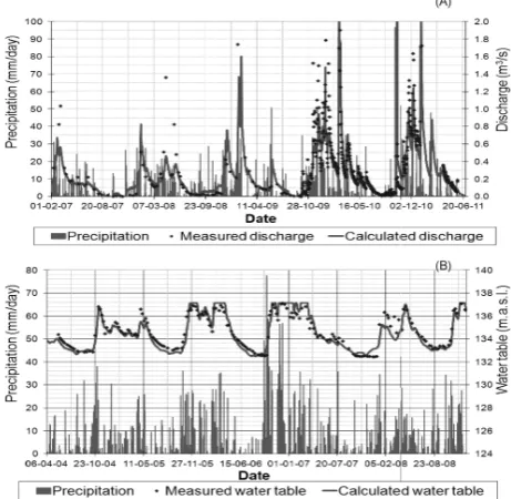
Fig. 4. Modeled versus measured flow rates in Abeleda Catchment (A) and modeled versus measured water table levels in Ferrol V Catchment (B).
model. A correction factor of 1.1 was applied for correcting gauged rainfall, according to the observed precipitation gra-dient for this location (Fig. 3).
The main parameters changed during the calibration pro-cess were: soil thickness, soil hydraulic conductivity, the per-colation, interflow and aquifer recession coefficients, curve number and the aquifer storage coefficient (Table 1). How-ever, they still remain in acceptable ranges according to bib-liographic values for similar terrains in the region (Soriano and Samper, 2000; Franco Bastianelli, 2010).
Visual Balan models can be calibrated using water table series, discharge series or both types of data. The calibra-tion criterion used in each catchment is shown in Table 2. Aquifer storage coefficient is only used by the model when water table data is available (i.e., Abeleda, Ferrol IV, Ferrol V and Landro II catchments). For the remaining catchments the aquifer storage coefficient cannot be computed, because the groundwater component of the model does not use this pa-rameter for discharge calculations.
Figure 4 shows the accordance obtained for modeled ver-sus measured flow rates and water table levels in two of the study catchments. The water level plateau in Fig. 4b cor-responds with the terrain surface. Water table in Ferrol V catchment is usually close to surface. During very rainy win-ters (like the period from 2005–2007), the water table almost reaches the terrain surface and soil saturation and ponding occurs occasionally. When the water table reaches the terrain surface, infiltration dramatically decreases and the model forces all the new water inputs to flow as run-off.
A validation process was not carried out for two reasons: firstly, a validation is not strictly necessary as no predictions are made with the model and the model is mainly used to de-rive the relation between recharge and precipitation; and sec-ondly, available historical data series (of water table and dis-charge rates) for the studied catchments are too short, there-fore, they may not be divided into two significant periods (one for calibration and other for validation).
[image:8.595.52.283.66.291.2]According to Winter (2001), climate, topography and the geologic framework are the three main factors in the hydro-logic landscape that control water flow. Rainfall supplies the land surface with water, the soil allows the water to infiltrate into the water table, and the geologic framework provides the permeability necessary for deeper flow. If the climatic and soil conditions allow recharge to reach the water table at a rate greater than the saturated zone can transmit the recharge away, then the permeability of the geologic framework con-trols the recharge rate. In this situation the underground wa-ter storage backs up to the point that excess infiltration is diverted overland, thus leading to a relatively shallow water table. In regions with relatively humid climate or low topo-graphic relief, the geologic framework controls the rate of recharge (Sanford, 2002). These are the conditions present in Galicia, with high average precipitation and thin soils with relatively high permeability, and the groundwater recharge is usually limited by the permeability and storage capacity of deep fractured bedrock. As a result of these conditions, water balance is usually dominated by interflow that flows laterally along the soil/bedrock interface.
In fact, it is not possible to establish a good relationship between groundwater recharge and annual precipitation; the percentage of recharge varies in this study from 13.7 % to 38.6 % depending on the catchment (Table 2). The same con-clusion was reached in studies carried out in similar aquifers in northern Portugal, where recharge varied widely from 1 % to 44 % depending on the catchment (Alenco˜ao et al., 2000; Da Silva Lima and Oliveira da Silva, 2000; Marques da Costa, 2000; Martins Carbalho et al., 2000; Mendes Oliveira and Lobo Ferreira, 2000; Pereira, 2000). The addition of ological criteria, reflecting the significant influence of the ge-ologic framework on groundwater recharge, is clearly neces-sary.
The statistical criteria used to evaluate the hydrologic goodness of fit were the coefficient of determination (R2)
and the model efficiency or Nash-Sutcliffe coefficient (E) (Nash and Sutcliffe, 1970). Both coefficients are highly af-fected by good matching records of high values. Errors in discharge measurement increase substantially during floods. As the main goal of this study is to evaluate the groundwa-ter recharge responsible for the stream base flow, the rela-tive Nash-Sutcliffe efficiency criteria (Erel)was also used
Table 1. Main parameters changed during the calibration process of the hydrological model and UTM coordinates of watersheds outlets.
Parameter Gafos L´erez Abeleda Ferrol IV Ferrol V Landro I Landro II Umia Mouro
Soil thickness (m) 1.43 0.65 0.65 1.61 1.50 0.60 1.61 2.02 1.10
Hydraulic conductivity (Kvs)(mm h−1) 7.20 18.18 6.84 4.41 6.84 10.01 9.49 5.06 3.54
Percolation recession coeff. (αp)(day−1) 0.2476 0.2887 0.071 0.0397 0.6931 0.5915 0.2456 0.6125 0.7461 Interflow recession coeff. (αh)(day−1) 0.4621 0.3151 0.271 0.287 0.6301 0.2175 0.5509 0.3587 0.5776 Aquifer recession coeff. (αs)(day−1) 0.0277 0.062 0.03843 0.07749 0.0866 0.0184 0.009 0.2376 0.04067
Aquifer storage coeff. (Sy) – – 0.01302 0.002664 0.00276 – 0.0051 – –
Curve number 55 55 55.2 60.3 56 55 60 40 44.15
UTM-X∗ 529 424 557 706 572 784 559 523 554 284 611 800 612 608 551 998 525 630
UTM-Y∗ 4 697 051 4 719 160 4 716 860 4 815 354 4 813 489 4 813 896 4 828 403 4 721 740 4 699 058
Basin area (km2) 26.26 6.23 9.88 2.18 0.32 3.20 0.47 6.88 3.67
Dominant geology Granites Schist Schist Granites Granites Granites/ Granites Granites Gneisses/
Quartzite Schist
∗Projected Coordinate System: WGS 1984 UTM, Zone 29◦N.
efficiency ranged from 0.70 to 0.82. A better fit was ob-tained during low flow rates, as shown by the Relative Nash-Sutcliffe index with a range of 0.76 to 0.87 (Table 2). In this study, two main geological blocks with different hydro-geological behavior were considered in Galicia-Costa: (a) quartzite and granitic rocks; and (b) metasedimentary rocks (slates, schists and gneisses). Although quartzite is a meta-morphic rock, from a hydrogeological point of view and for the purposes of this study, it is considered to be more similar to granites due to its weathering products and high bedrock fracturing degree that favors greater water storage capaci-ties. On the contrary, Galician schist and slates usually have closed fractures at high depth (Samper, 2003) and thus their aquifer storage capacity is filled quickly during high precip-itation.
When all available recharge estimations in Galicia and Northern Portugal are plotted distinguishing the hydroge-ology framework (Fig. 5), a clear relationship is observed (R2>0.9). Groundwater recharge increases with precipita-tion according to a logistic curve, but the recharge threshold and growing rate are clearly different. The small thickness of soil usually present on schists (except in the “Ordes” Com-plex) favors groundwater recharge even during low rainfall, while in the same conditions the deeper soil that may form in granite terrains favors evapotranspiration. An asymptotic limit due to the aquifer storage capacity is also observed (Alenco˜ao et al., 2000). This limit is higher in granitic and quartzitic aquifers than in metasedimentary aquifers due to the greater secondary permeability observed in granites and quartzite versus slates, schists and gneisses. Therefore, gran-ite formations are more interesting for groundwater purposes in areas with high precipitation, while schists are better under moderate rainfall conditions.
Temporal variability of groundwater recharge was ob-tained for the nine pilot catchments, based on the daily water balance model. Distribution of groundwater recharge throughout the year is strongly dependent on rainfall and presents only minor differences depending on the geological
Fig. 5. Relationship between groundwater recharge and precipita-tion, depending on the geology. Filled symbols correspond with data gathered in Galicia-Costa area; other data were gathered from catchments in the nearby Northern Portugal.
framework, following a similar pattern to precipitations. 74 % of groundwater recharge is concentrated in the first six months of the hydrologic year, while during the summer (July, August and September) only 6.7 % of the total recharge occurs (Fig. 6).
The unequal temporal distribution of rainfall and ground-water recharge, in combination with the limited storage ca-pacity of fractured bedrock aquifers (average storage co-efficient equal to 0.0059) and the short residence time of groundwater in them (average recession coefficient equal to 0.066 day−1 and average time of semi-depletion of ground-water discharge equals to 22.85 days) reduces the availability to develop this resource to supply big cities.
7 Chloride mass balance results
[image:9.595.309.545.257.362.2]Table 2. Results and evaluation of the hydrologic goodness of fit in the studied catchments.
Gafos L´erez Abeleda Ferrol IV Ferrol V Landro I Landro II Umia Mouro Basin (calibration criteria)
(discharge) (discharge) (discharge/ (discharge/ (water-table) (discharge) (water-table) (discharge) (discharge) water-table) water-table)
Average precipitation (mm yr−1) 1488 1598 1183 1254 1250 2029 1022 1996 2089 ETa(%P) 22.5 % 10.6 % 21.1 % 37.5 % 31.5 % 21.9 % 31.3 % 14.2 % 17.8 % Groundwater Recharge (%P) 15.9 % 32.1 % 27.2 % 15.0 % 16.8 % 40.9 % 9.1 % 42.1 % 25.5 % Run-off (%P) 11.0 % 9.3 % 3.7 % 6.8 % 3.8 % 11.6 % 2.7 % 0.02 % 5.1 % Interflow (%P) 42.7 % 41.6 % 41.3 % 31.6 % 41.2 % 19.2 % 46.1 % 38.5 % 42.7 % Rainfall interception (%P) 7.9 % 6.4 % 6.7 % 9.1 % 6.8 % 6.4 % 10.8 % 6.2 % 8.9 % Coeff.R2 0.8010 0.7413 0.7646/ 0.8215/ 0.8916 0.7850 0.9863 0.8579 0.7611
0.7369 0.8025
Nash-Sutcliffe 0.7014 0.7138 0.7489 0.8174 – 0.7460 – 0.7961 0.8218 Relative Nash-Sutcliffe 0.8530 0.8370 0.8480 0.7745 – 0.8732 – 0.8566 0.8185
Fig. 6. Temporal variability of groundwater recharge: average per-centage of monthly groundwater recharge and precipitation along the year in the nine pilot catchments.
In order to compute the CMB, a comprehensive biblio-graphic revision was carried out looking for historic data of chloride concentration in rainfall in Galicia (Alcal´a and Cus-todio, 2008a; Fern´andez-Sanjurjo et al., 1997; Garc´ıa-Rodeja et al., 1998; G´omez Rey et al., 2002; Prada-Sanchez et al., 1993; Silva et al., 2007; V´azquez et al., 2003). In order to uniformly cover all of Galicia-Costa, 122 rainfall samples were collected and analyzed in 2008 (a year with average precipitation within the normal range for Galician climate) from 56 locations where no bibliographic data were available (Fig. 7a). Samples were preferably taken close to the basins where any hydrological models were performed, in order to compare the results. This sampling procedure consisted of directly gathering rainwater in portable collectors during dif-ferent salient rainfall events and immediately transporting the samples to the laboratory in order to avoid any possible evaporation effects on the subsequent chloride concentration analysis. This procedure assumes that Cl−dry deposition is negligible due to the wet Galician climate and high frequency of rainfall events.
On the other hand, since 2007 groundwater chloride con-centration has been analyzed on a bimonthly basis in 54 lo-cations included in the groundwater quality network of Au-gas de Galicia (Fig. 7b). These chloride data were added
to groundwater samples collected in a sole field study in 2006 and the available bibliographic data (Alcal´a, 2005; Rodr´ıguez Blanco et al., 2003).
An interpolation by the inverse distance weighted method of punctual chloride data in groundwater and rainfall was car-ried out using a GIS tool.
Groundwater chloride concentration follows a geographi-cal and topographigeographi-cal pattern (Guan et al., 2010): maximum concentrations of chloride are found in coastal areas, while minimum concentrations are found in inland mountainous ar-eas (Fig. 7b).
Assuming in this study an average runoff (overland plus interflow) equal to 44.57 % of total precipitation (Table 2) and a homogeneous concentration factor equal to 1.17 (Al-cal´a, 2005), groundwater recharge was computed according to Eq. (12). Maximum groundwater recharge is reached in mountainous areas (e.g. Xistral, Suido and Testeiro Moun-tains) where high rainfall and high recharge rates converge (Fig. 7c).
A comparison of results was carried out wherever ground-water recharge was obtained by both methodologies (the hy-drological model and the CMB) (Table 3). The consistency of these results confirms the validity of the computed ground-water recharge (Fig. 8).
8 Global groundwater resource assessment in Galicia-Costa
Reasonable estimates of recharge over extended areas can be derived using readily obtained field data without having to consider the complicating aspects of small-scale (local) vari-ability (de Vries and Simmers, 2002). The combination of re-liable local data and GIS technology offers promise for a bet-ter understanding and quantification of recharge over large areas (de Vries and Simmers, 2002).
[image:10.595.51.284.234.365.2]Fig. 7. Map of chloride concentration in rainfall (A), in groundwater (B), and groundwater recharge computed by chloride mass balance (C).
Table 3. Comparison of groundwater recharge computed by different methodologies.
Recharge rate (% precipitation)
Basin [Cl
−
rainfall] [Cl
−
GW] Interflow + runoff Chloride mass Hydrological (mg l−1) (mg l−1) (%Precip.) balance model
Ferrol IV+V 12.54 35 41.65 % 18.37 % 15.9 %
Landro I 5.51 7.88 30.8 % 44.77 % 40.9 %
L´erez 4.47 6.03 50.9 % 29.98 % 32.1 %
Gafos 4.21 12.39 53.7 % 12.63 % 15.9 %
Umia 4.47 7.05 38.5 % 34.44 % 42.1 %
Landro II 7.57 20.71 48.8 % 15.68 % 9.1 %
Mouro 6.01 13.31 47.8 % 19.90 % 25.5 %
Vali˜nas 3.42 13.32 45.9 %∗ 11.89 % 8.8 %∗
∗Model data from (Samper et al., 1997).
Fig. 8. Groundwater recharge computed by hydrological models versus chloride mass balance results.
function of simplified geology, the district was divided into four main blocks that were assumed to have similar hydro-geological behavior (Fig. 9a). Based on the studies carried out using the hydrological models in the pilot catchments cross-validated with the CMB, an equation as a function of annual precipitation was established to calculate the ground-water recharge for each one of the two main hydrogeological areas in Galicia-Costa: granites and quartzite (Eq. 13) and metasedimentary rocks (Eq. 14).
Recharge=62.425+ 822.215
1+11.44×e−0.0264×P+47.980.139 (13)
Recharge=88.425+ 505.162
1+3.59×e−0.00275×P−0.11435.336
. (14)
[image:11.595.55.281.458.641.2]Fig. 9. Main geological units (A) considered for extrapolation of water balance models results and groundwater recharge (B) obtained for Galicia-Costa district by a GIS tool as a function of precipitation and geology.
Recharge (mm yr−1)=A+ K−A
1+Q×e−B×P−Mv (15) where K and A represent the maximum and minimum asymptotic limits of recharge, B represents the recharge growth rate,P is the annual precipitation in mm yr−1 and
Q,MandV are constants dependent on the geology. Inside the metasedimentary rock group, the schistose Complex of Ordes, along with the neighboring basic and ultrabasic rocks, present a particular set of hydrogeological characteristics. Schists from the Complex of Ordes, com-pared to the rest of the slates, phyllites and schists present in Galicia, are less rich in quartz and therefore weathered more easily (Fern´andez and Mac´ıas V´azquez, 1985). Con-sequently, the soils that develop over the Complex of Or-des reach greater depths. These soils also present silt-loamy textures that make them susceptible to surface crusting pro-cesses; as a result groundwater infiltration during heavy rains is significantly reduced (Paz-Gonz´alez et al., 2001). Accord-ing the IGME (Hern´andez Urroz et al., 1981), the rocks that constitute the Complex of Ordes have a negligible primary permeability and a very low secondary permeability. This complex of rocks corresponds to the area with the lowest density of faults and fractures in Galicia-Costa (Fig. 1). This characteristic reduces the water storage capacity in the sec-ondary porosity of the bedrock. For these reasons groundwa-ter recharge rate in the Complex of Ordes is assumed to be lower than in the rest of the metasedimentary rocks. An av-erage recharge of 8.4 % of the precipitation (obtained from CMB) is assumed.
Finally, quaternary deposits represent a very low area in Galicia-Costa and the recharge coefficient for these detrital deposits is assumed to be 22 % of the precipitation (Control y Geolog´ıa S.A., 2005).
Figure 9b shows the spatial distribution of groundwater recharge in Galicia-Costa, depending on climatic and geo-logical factors. Comparison of this map with those obtained by CMB (Fig. 8c) shows a consistency in the results. Results indicate that the water balance method is a powerful tool in understanding the main features of recharge processes when short time steps are used and the spatial variability of com-ponents is taken into account (de Vries and Simmers, 2002). Total groundwater resources in Galicia Costa are signifi-cant. An annual groundwater recharge of 4427 hm3was esti-mated for the whole district, an amount significantly higher than estimated in previous studies. The greatest groundwa-ter recharge rates occur in southwesgroundwa-tern granitic areas with a high annual precipitation (Fig. 9b).
Fig. 10. Sensitivity analysis of model parameters on estimated recharge, average results for the nine pilot basins (only the eight most sensitive parameters are showed). CP is the relative change of a given variable or parameter and AS is the relative change in the recharge value.
derived from this use could safely be deemed negligible. This approach appears to be more sustainable than surface water-based solutions both from an ecological and economi-cal point of view.
9 Uncertainty and sensitivity analysis
The estimation of groundwater recharge contains several po-tential sources of uncertainty related to the methodological approach used, the parameters estimation and/or the upscal-ing process.
Combining and comparing methods allows for the devia-tion of estimates provided by different techniques applied in the same hydrological zone to be known (Flint et al., 2002). Differences between punctual estimates with both methods used are lower than 7.7 % (Table 4)
The uncertainties associated with the model parameters were evaluated by computing the relative sensitivity criteria AS/CP (Eq. 16) defined by Jim´enez-Mart´ınez et al. (2010),
Relative sensitivity:AS CP =
|Cs−Cb| ×100Cb
|Ps−Pb| ×100Pb
(16)
where CP is the relative change of a given variable or param-eter and AS is the relative change in the output (recharge) value,Ps andPbare variable values used for sensitivity and
calibrated base runs, respectively, andCs andCbare output
data (recharge) computed in sensitivity and calibrated base runs, respectively. When tolerable ranges allows it, the mag-nitude of the parameter perturbation (CP) was fixed from −50 % to +100 % with respect to the original data. Fig-ure 10 shows the effect on the estimated recharge in a se-ries of simulations where each parameter was modified ac-cording to a fixed perturbation while all other parameters re-mained at their baseline values. Only the eight most sensi-tive parameters are shown. The most sensisensi-tive parameters are
interflow and percolation recession coefficients, curve num-ber and field capacity. The sensitivity criteria AS/CP is lower than 0.35 for the remaining model parameters.
The main uncertainty source for recharge estimation by CMB is the lack of chloride concentration in runoff water data and the assumption of a unique concentration factor (Fc) for the whole of Galicia-Costa. A sensitivity analysis of Fc on recharge estimation was carried out by changing Fc in the range of values observed in Northern Spain from 1 to 1.5 (Al-cal´a, 2005). A high sensitivity was observed with an average variation of recharge estimates from −16.67 % to 32.35 % with respect to the baseline obtained with Fc = 1.17.
10 Summary and conclusions
A relation among groundwater recharge and total precipita-tion according to a logistic curve was found for both of the two main geologies in Galicia-Costa. These curves satisfac-torily reproduced the estimated recharge values in several pi-lot basins along the study area during different hydrologi-cal years that includes a range of climatic conditions. No-table differences are observed in hydrogeological behavior of granite and metasedimentary rocks despite both are fractured crystalline rocks. Groundwater recharge is greater in schists than in granites when precipitation is moderate. However, schists present a lower storage capacity that limits recharge when annual precipitation is higher, whereas recharge in granites continues to rise at a high growth rate. Therefore, granite formations are more interesting for groundwater pur-poses in areas of high precipitation. It is remarkable that pre-cipitation higher than 1800–2000 mm yr−1barely contributes
to a recharge increase; as it fills the storage capacity in both rock types, the excess water is forced to flow as runoff and interflow.
Total groundwater resources in Galicia-Costa were esti-mated at 4427 hm3yr−1, significantly higher than in previous studies.
Main uncertainties in model recharge estimations are as-sociated with the large number of used parameters. However, only a few parameters (i.e., interflow and percolation reces-sion coefficients, curve number, and field capacity) present high sensitivity on recharge estimations. Since modeled dis-charge and water table levels strongly depend on these pa-rameters too, an accurate daily calibration of the models is required for a correct estimation of these sensitive parame-ters.
Groundwater recharge shows a highly unequal spatial dis-tribution in Galicia-Costa depending on the climatic and ge-ologic factors. For example, maximum recharge is found in mountainous areas in the southwest where high annual pre-cipitation and fractured granitic bedrock are present.
The large temporal variability of groundwater recharge, the short residence time of groundwater, the limited storage capacity and the small size of Galician aquifers on fractured bedrock make the exploitation of this resource difficult for large pumping centers. However, groundwater resources are particularly suitable for water supply to small villages and scattered rural populations by means of multiple small pump-ing centers. 40 % of the total Galicia-Costa population could be supplied by groundwater using less than 1 % of its total resources, with a minimum environmental impact.
Acknowledgements. This work has been co-funded by Augas de Galicia and the Galician government Xunta de Galicia, within the framework of research project INCITE09 203 072 PR and by the European Regional Development Fund (ERDF). The first author has been granted a F.P.U. fellowship by the Spanish Ministry of Education. The authors would like to thank the comments from the editor and two anonymous reviewers that undoubtedly improved the quality of this paper.
Edited by: I. Neuweiler
References
Alcal´a, F. J.: Recarga a los acu´ıferos espa˜noles medi-ante balance hidrogeoqu´ımico [Recharge in Spanish aquifers by means of hydrogeochemical balance] the-sis/masters, Universidad Polit´ecnica de Catalu˜na, avail-able at: http://www.tdx.cat/handle/10803/6240;jsessionid= A4C27AD702E6C20580EED864246D3A1C.tdx2 (last access: 2 December 2011), 2005.
Alcal´a, F. J. and Custodio, E.: Atmospheric chloride deposition in continental Spain, Hydrol. Process., 22, 3636–3650, 2008a. Alcal´a, F. J. and Custodio, E.: Flujo de cloruro por la escorrent´ıa
directa en Espa˜na [Chloride flux by direct runoff in Spain], Ingenier´ıa del agua, 15, 5–11, avaliable at: http://upcommons. upc.edu/revistes/bitstream/2099/10708/1/I-V15N1.pdf (last ac-cess: 7 December 2011), 2008b.
Alenco˜ao, A., Pacheco, F., and Ferreira, M. P.: A bacia hidrogr´afica do rio Corgo (NE Portugal): escoamento sub-terrˆaneo e par´ametros influentes [The basin of river Corgo (NE Portugal): groundwater recharge and involved parameters], in: Las Aguas Subterr´aneas en el Noroeste de la Pen´ınsula Ib´erica, edited by: Samper, J., Leit˜ao, T., Fern´andez, L., and Ribeiro, L., IGME, Madrid, Spain, 173–182, 2000.
Allen, R. G., Pereira, L. S., Raes, D., and Smith, M.: Crop evap-otranspiration – Guidelines for computing crop water require-ments – FAO Irrigation and drainage paper 56, FAO, Rome, 1998.
Allison, G. B. and Hughes, M. W.: The use of natural tracers as in-dicators of soil-water movement in a temperate semi-arid region, J. Hydrol., 60, 157–173, 1983.
Banks, D., Gundersen, P., Gustafson, G., M¨akel¨a, J., and Morland, G.: Regional similarities in the distributions of well yield from crystalline rocks in Fennoscandia, Norg. Geol. Unders. B., 450, 33–47, 2010.
Barral, M. T., Ariasa, M., and Gu´erif, J.: Effects of iron and organic matter on the porosity and structural stability of soil aggregates, Soil Till. Res., 46, 261–272, 1998.
Bradford, R. B., Ragab, R., Crooks, S. M., Bouraoui, F., and Pe-ters, E.: Simplicity versus complexity in modelling groundwater recharge in Chalk catchments, Hydrol. Earth Syst. Sci., 6, 927– 937, doi:10.5194/hess-6-927-2002, 2002.
Candela, L., von Igel, W., Javier Elorza, F., and Aronica, G.: Impact assessment of combined climate and management scenarios on groundwater resources and associated wetland (Majorca, Spain), J. Hydrol, 376, 510–527, 2009.
Carballeira, A., Devesa, C., Retuerto, R., and Santill´an, E.: Biocli-matolog´ıa de Galicia [Bioclimatology of Galicia], Fundaci´on Pe-dro Barri´e de la Maza, A Coru˜na, Spain, 1983.
Carrica, J. C.: Natural recharge evaluation of the aquifer in the upper Arroyo Napost´a Grande basin, province of Buenos Aires, Revista de la Asociaci´on Geol´ogica Argentina, 59, 281–290, 2004. Casta˜neda, C. and Garc´ıa-Vera, M. A.: Water balance in the
playa-lakes of an arid environment, Monegros, NE Spain, Hydrogeol. J., 16, 87–102, 2008.
Church, R.: Sensitivity testing of the methodology for groundwater recharge assessment, Report project WFD31, Sniffer, Edinburgh, 37 pp., 2004.
Control y Geolog´ıa S.A.: Estudio de caracterizaci´on de las masas de agua subterr´anea y el dise˜no de una red de control de las aguas subterr´aneas [Characterization of groundwater bodies and design of a monitoring network of groundwater], Expediente: EC01404AT, Santiago de Compostela, Spain, 2005.
Cook, P. and B¨ohlke, J.: Determining timescales for groundwater flow and solute transport, Environmental tracers in subsurface hydrology, edited by: Cook, P. and Herczeg, A. L., Kluwer Aca-demic Publishers, Boston, 1–30, 2000.
Custodio, E.: Evaluaci´on de la recarga por la lluvia mediante m´etodos ambientales qu´ımicos, isot´opicos y t´ermicos [Evalua-tion of rainfall recharge by means of chemical, isotopic and ther-mal environmental methods], in: La Evaluaci´on de la Recarga a los Acu´ıferos en la Planificaci´on Hidrol´ogica, edited by: Custo-dio, E., Llamas, M. R., and Samper, J., IGME, Las Palmas de Gran Canaria-Madrid, Spain, 83–110, 1997.
Da Silva Lima, A. and Oliveira da Silva, M.: Estimativa da recarga em terrenos gran´ıticos: uma discuss˜ao [Recharge estimation in granitic terrains: a discussion], in: Las Aguas Subterr´aneas en el Noroeste de la Pen´ınsula Ib´erica, edidet by: Samper, J., Leit˜ao, T., Fern´andez, L., and Ribeiro, L., IGME, Madrid, Spain, 183– 190, 2000.
Dafonte, J. and Raposo, J. R.: Estudio del potencial hidrogeol´ogico de las fincas de Bosques Naturales en Arz´ua y Boimorto para el potencial aprovechamiento de las aguas subterr´aneas [Hydroge-ological survey in the plots of Bosques Naturales for potential groundwater use], unpublished technical report, 2009.
de Vries, J. J. and Simmers, I.: Groundwater recharge: an overview of processes and challenges, Hydrogeol. J., 10, 5–17, 2002. Environment Agency: The North Cornwall Catchment Abstraction
Eriksson, E. and Khunakasem, V.: Chloride concentration in groundwater, recharge rate and rate of deposition of chloride in the Israel Coastal Plain, J. Hydrol., 7, 178–197, 1969.
Espinha-Marques, J., Samper, J., Pisani, B., Alvares, D., Carvalho, J. M., Chamin´e, H. I., Marques, J. M., Vieira, G. T., Mora, C., and Sodr´e-Borges, F.: Evaluation of water resources in a high-mountain basin in Serra da Estrela, Central Portugal, using a semi-distributed hydrological model, Environ. Earth Sci., 62, 1219–1234, 2011.
Estrela, T., Cabezas Calvo-Rubio, F., and Estrada Lorenzo, F.: La evaluaci´on de los recursos h´ıdricos en el Libro Blanco del Agua en Espa˜na [The assessment of water resources in the White Book of Water in Spain], Ingenier´ıa del agua, 6, 125–138, 1999. European Commission: Directive of the European Parliament and
of the Council 2000/60/EC establishing a framework for Com-munity action in the field of water policy, CELEX-EUR Official Journal L, 327, 1–72, 2000.
Fern´andez, M. and Mac´ıas V´azquez, F.: Contribuci´on a la carac-terizaci´on qu´ımico-mineral´ogica de los esquistos del “Complejo de Ordes” [Contribution to chemical-mineralogical characteriza-tion of schists from the “Complex of Ordes”], Cuad. Lab. Xe., 9, 469–494, 1985.
Fern´andez-Sanjurjo, M. J., Vega, V. F., and Garc´ıa-Rodeja, E.: At-mospheric deposition and ionic concentration in soils under pine and deciduous forests in the river Sor catchment (Galicia, NW Spain), Sci. Total Environ., 204, 125–134, 1997.
Flint, A. L., Flint, L. E., Kwicklis, E. M., Fabryka-Martin, J. T., and Bodvarsson, G. S.: Estimating recharge at Yucca Mountain, Nevada, USA: comparison of methods, Hydrogeol. J., 10, 180– 204, 2002.
Forn´es, J. M., de la Hera, ´A., and Llamas, M. R.: The silent rev-olution in groundwater intensive use and its influence in Spain, Water Policy, 7, 253–268, 2005.
Fou´ep´e Takounjou, A., Ndam Ngoupayou, J. R., Riotte, J., Takem, G. E., Mafany, G., Mar´echal, J. C., and Ekodeck, G. E.: Estima-tion of groundwater recharge of shallow aquifer on humid envi-ronment in Yaounde, Cameroon using hybrid water-fluctuation and hydrochemistry methods, Env. Earth Sciences, 64, 107–118, 2010.
Franco Bastianelli, S.: Estudio sobre las posibles causas de los da˜nos en las edificaciones de un ´area del casco urbano de Pon-teceso [Study on possible causes of damage to buildings in an urban area of Ponteceso] Technical report, INGEBAIRES, Vigo, available at: http://www.ponteceso.net/informe/informefinal.pdf (last access: 18 March 2012), 2010.
Garc´ıa-Rodeja, E., Fern´andez-Sanjurjo, M. J., and Fern´andez-Vega, V.: Input-output ion fluxes in the River Sor catchment (Galicia, NW Spain), Chemosphere, 36, 1107–1112, 1998.
Garcia-Santos, G. and Marzol, V.: Groundwater recharge in a moun-tain cloud laurel forest at the Garajonay National Park (Spain), Geophys. Res. Abstr., EGU2005-A-00942, EGU General As-sembly 2005, Vienna, Austria, 2005.
G´omez Rey, M., De Anta, C., and Mar´ıa, R.: Datos para el desar-rollo de una red integrada de seguimiento de la calidad de los suelos en Galicia (N. O de Espa˜na): Balances geoqu´ımicos en suelos forestales (Pinus radiata). 1. Aportes de elementos por dis-posici´on atmosf´erica y hojarasca [Data for the development of an integrated monitoring network of soil quality in Galicia (NW Spain)], Edafolog´ıa, 9, 181–196, 2002.
Gonz´alez-Arias, A., Amezaga, I., Echeand´ıa, A., and Onaindia, M.: Buffering capacity through cation leaching of Pinus radiata D. Don canopy, Plant Ecol., 149, 23–42, 2000.
Guan, H., Love, A. J., Simmons, C. T., Makhnin, O., and Kayaalp, A. S.: Factors influencing chloride deposition in a coastal hilly area and application to chloride deposition mapping, Hydrol. Earth Syst. Sci., 14, 801–813, doi:10.5194/hess-14-801-2010, 2010.
Healy, R. W., Gray, J. R., de Vries, M. P., and Mills, P. C.: Wa-ter balance at a low-level radioactive disposal site, J. Am. WaWa-ter Resour. As., 25, 381–390, 1989.
Hern´andez Urroz, J., Divar Rodr´ıguez, J., Diez Balda, M. A., and Mart´ınez Catal´an, J. R.: Mapa Geol´ogico Nacional de Espa˜na, Hoja 70, ´Ordenes [National Geologic Map of Spain, Sheet 70 corresponding to ´Ordenes], 1:50000, 1981.
Hernandez-Mora, N., Llamas, M., and Mart´ınez Cortina, L.: Mis-conceptions in aquifer overexploitation: implications for wa-ter policy in Southern Europe, Agricultural use of groundwa-ter. Towards integration between agricultural policy and water resources management, Kluwer Academic Publishers, 107–125, 2001.
Horton, R. E.: Rainfall interception, Mon. Weather Rev., 47, 603– 623, 1919.
IGME: Cartograf´ıa Geol´ogica Continua Digital de Espa˜na (GEODE) [Continuous Digital Geological Map of Spain], 1:50000, 2004.
INE: Encuesta sobre el suministro y saneamiento del agua en el a˜no 2009 [Survey on water supply and sanitation in 2009], avail-able at: www.ine.es/prensa/np659.pdf (last access: 15 Decem-ber 2011), 2009.
Jim´enez-Mart´ınez, J., Candela, L., Molinero, J., and Tamoh, K.: Groundwater recharge in irrigated semi-arid areas: quantitative hydrological modelling and sensitivity analysis, Hydrogeol. J., 18, 1811–1824, 2010.
Knutsson, G.: Hydrogeology in the Nordic countries, Episodes, 31, 1–7, 2008.
Kr´asn´y, J.: Quantitative hardrock hydrogeology in a regional scale, Norg. Geol. Unders. B., 439, 7–14, 2002.
Krause, P., Boyle, D., and B¨ase, F.: Comparison of different effi-ciency criteria for hydrological model assessment, Adv. Geosci., 5, 89–97, 2005,
http://www.adv-geosci.net/5/89/2005/.
Lima, A. S. and Silva, M. O.: Estudo hidrogeol´ogico dos granit´oides da regi˜ao de Braga (NW de Portugal) [Hydrogeological study of granites in Braga region (NW of Portugal)], in: Mem´orias no. 4. Museu e Laborat´orio Mineral´ogico e Geol´ogico da Faculdade de Ciencias da Universidade do Porto, edited by: Borges, F. S. and Marques, M. M., Porto, Portugal, 461–465, 1995.
Llamas, M. R. and Mart´ınez-Santos, P.: Intensive groundwater use: Silent revolution and potential source of social conflicts, J. Water Res. Pl.-ASCE, 131, 337–341, 2005.
Marques da Costa, A.: Estado actual do conhecimento das ´aguas subterrˆaneas no norte de Portugal [Current state of knowledge of groundwater in northern Portugal], in: Las Aguas Subterr´aneas en el Noroeste de la Pen´ınsula Ib´erica, edited by: Samper, J., Leit˜ao, T., Fern´andez, L., and Ribeiro, L., IGME, Madrid, 129– 146, 2000.
Martin, N. and van de Giesen, N.: Spatial distribution of groundwa-ter production and development potential in the Volta River basin of Ghana and Burkina Faso, Water Int., 30, 239–249, 2005. Mart´ınez, A. I., Molinero, J., Dafonte, J., and Gal´ındez, J. M.: Toma
de datos y modelizaci´on hidrogeol´ogica de un acu´ıfero k´arstico de alta monta˜na (Valle de la Respina, Le´on) [Data gathering and hydrogeological modeling of a high-mountain karst aquifer (Respina Valley, Le´on)], in: From data gathering and groundwa-ter modelling to integratd management, edited by: S´anchez-Vila, X., del Carmen Cabrera, M., Santana, M. C. C., and Valverde, M., IGME, Madrid, 459–464, 2006.
Martins Carbalho, J., Plasˆencia, N., Chamin´e, H. I., Rodrigues, B. C., Guerner Dias, A., and Antunes da Silva, M.: Recursos h´ıdricos subterˆaneos em formac¸oes cristalinas do norte de Portu-gal [Groundwater resources in crystalline bedrock in North Por-tugal], in: Las Aguas Subterr´aneas en el Noroeste de la Pen´ınsula Ib´erica, edited by: Samper, J., Leit˜ao, T., Fern´andez, L., and Ribeiro, L., IGME, Madrid, 163–172, 2000.
Massuel, S., George, B., Gauer, A., and Nune, R.: Groundwa-ter modeling for sustainable resource management in the Musi catchment, India, in: Proceedings of the International Congress on Modelling and Simulation, Christchurch, New Zealand, 10– 13 December 2007, 1425–1439, 2007.
McCartney, M. P. and Houghton-Carr, H. A.: An Assessment of Groundwater Recharge on the Channel Island of Jersey, Water Environ. J., 12, 445–451, 1998.
Memon, B.: Quantitative analysis of springs, Environ. Geol., 26, 111–120, 1995.
Mendes Oliveira, M. and Lobo Ferreira, J. P. C.: Estudo da recarga de ´aguas subterrˆaneas em ´areas do macic¸o antigo do norte de Por-tugal continental [Study of groundwater recharge in areas of the Hercynian Massif in North Portugal], in: Las Aguas Subterr´aneas en el Noroeste de la Pen´ınsula Ib´erica, edited by: Samper, J., Leit˜ao, T., Fern´andez, L., and Ribeiro, L., IGME, Madrid, 191– 198, 2000.
Molinero Huguet, J., Soriano Hoyuelos, G., and Samper Calvete, J.: Calidad y contaminaci´on de las aguas subterr´aneas en Gali-cia: situaci´on actual y estudio de detalle en la cuenca del Vali˜nas [Quality and contamination of groundwater in Galicia: present situation and detailed study in the Vali˜nas catchment], in: Jor-nadas sobre la contaminaci´on de las aguas subterr´aneas: un prob-lema pendiente, edited by: Samper, J., Sahuquillo, A., Capilla, J. E., and G´omez Hern´andez, J. J., AIH-GE, Valencia, 255–260, 1998.
Murphy, E. M., Ginn, T. R., and Phillips, J. L.: Geochemical es-timates of paleorecharge in the Pasco Basin: Evaluation of the chloride mass balance technique, Water Resour. Res., 32, 2853– 2868, 1996.
Nash, J. E. and Sutcliffe, J.: River flow forecasting through concep-tual models part I – A discussion of principles, J. Hydrol., 10, 282–290, 1970.
Navarro Alvargonz´alez, A., Fern´andez Ur´ıa, A., and Doblas Dom´ınguez, J. G.: Las aguas subterr´aneas en Espa˜na: Estudio
de s´ıntesis [Groundwater in Spain: Study of synthesis], Instituto Tecnol´ogico Geominero de Espa˜na, Madrid, 1993.
Neal, C. and Kirchner, J. W.: Sodium and chloride levels in rain-fall, mist, streamwater and groundwater at the Plynlimon catch-ments, mid-Wales: inferences on hydrological and chemical con-trols, Hydrol. Earth Syst. Sci., 4, 295–310, doi:10.5194/hess-4-295-2000, 2000.
Paz-Gonz´alez, A., Thonon, I., Bertolani, F. C., Taboada-Castro, M. M., Vidal-V´azquez, E., and Dafonte, J. D.: Variabilidad espacial de la infiltraci´on en una ladera determinada con perme´ametro de Guelph e infiltr´ometro de tensi´on [Spatial variability of wa-ter infiltration in a fixed hillslope with Guelph permeamewa-ter and tension infiltrometer], in: Temas de investigaci´on en la zona no saturada, edited by: L´opez Rodr´ıguez, J. J. and Quemada Sa´ez-Badillos, M., Universidad P´ublica de Navarra, Pamplona, Spain, 51–60, 2001.
Paz-Gonz´alez, A., D´ıaz-Fierros Viqueira, F., Soto Gonz´alez, B., and L´opez Periago, E.: Uso de un modelo basado en eventos para evaluar la conductividad hidr´aulica en una cuenca de peque˜nas dimensiones [Using an event-based model to evaluate the hy-draulic conductivity in a small basin], in: Estudios de la Zona No Saturada del Suelo. Actas de las VI jornadas sobre investiga-cion de la zona no saturada del suelo, edited by: ´Alvarez-Bened´ı, J. and Marinero, P., Instituto Tecnol´ogico Agrario de Castilla y Le´on, 313–318, 2003.
Pereira, M. R.: Quantificac¸˜ao da recarga subterrˆanea em rochas frac-turadas da bacia hidrogr´afica do Tua [Quantification of ground-water recharge on fractured rocks in river Tua basin], in: Las Aguas Subterr´aneas en el Noroeste de la Pen´ınsula Ib´erica, edited by: Samper, J., Leit˜ao, T., Fern´andez, L., and Ribeiro, L., IGME, Madrid, 155–162, 2000.
Prada-Sanchez, J., Garcia-Jurado, I., Gonzalez-Manteiga, W., Fiestras-Janeiro, M., Espada-Rios, M., and Lucas-Dominguez, T.: Multivariate statistical analysis of precipitation chemistry in northwestern Spain, Water Air Soil Poll., 69, 37–55, 1993. Press, W., Flannery, B., Teukolsky, S., and Vetterling, W.:
Numeri-cal Recipes in PasNumeri-cal, Cambridge, 1989.
Prych, E. A.: Using chloride and chlorine-36 as soil-water tracers to estimate deep percolation at selected locations on the US De-partment of Energy Hanford Site, Washington, US Geological Survey, 1998.
Raposo, J. R., Molinero, J., and Dafonte, J.: Quantitative evaluation of hydrogeological impact produced by tunnel construction using water balance models, Eng. Geol., 116, 323–332, 2010. Robins, N. S.: Regional hydrogeological assessment of Wales, in:
Urban geology in Wales, edited by: Bassett, M. G., Boulton, H., and Nicol, D., National Museum of Wales, Cardiff, Wales, 141– 150, 2009.
Robins, N. S. and Misstear, B. D. R.: Groundwater in the Celtic regions, Geol. Soc. Spec. Publ., 182, 5–17, 2000.
Robins, N. S. and Smedley, P. L.: The Jersey groundwater study, British Geological Survey Research Report RR/98/5, 48 pp., 1998.
Robins, N. S., Griffiths, K. J., Merrin, P. D., and Darling, W. G.: Sustainable groundwater resources in a hard-rock island aquifer – the Channel Island of Guernsey, Geol. Soc. Spec. Publ., 193, 121–132, 2002.