Speculation Route APIs for Specific Query Perform using Intellectual
Transport Methods
Shaik Fakhruzzaman1, S.G Nawaz2
1PG Scholar, Dept of CSE, , Sri Krishna Devaraya Engineering College,Gooty,Anantapuram Dist,AP.
2
Associate Professor,Dept of CSE, Sri Krishna Devaraya Engineering College,Gooty,Anantapuram Dist,AP.
ABSTRACT: Mobile Technology is one of the speed growing models to improve the
communication number of people. With tremendous implement in mobile technology. The
information is a senior software development project where students use the collaboration tool
TRAC. We extract patterns sharing the better from the weaker groups and get insights in the
success tracks. The congested road segments are detected through analyzing the intellectual of
change objects on the road network. The modern degree of every road functions and total
forwarding speed of vehicles in a road segment are computed to detect the congested road
segments. Travel time predicting models have been planned intensively as a subject of
Intellectual Transport Methods (ITM) is progressive traffic flow managing methods (PTMM)
and progressive traveler info methods (PTIM). Now the consider for the travel time predicting
and modify and finding, particularly since the market for location-based services (LBS) are
forecasted to be rapidly improved. The model can support three kinds of queries for location data
is considering the near future, but also the far future. In order to finding the results of the
DSTTMOD model, a prototype system is developed and a series of experiments are conducted
which show promising performance.
Index Terms: Intellectual Transport Methods (ITM), Progressive Traffic Flow Managing
Methods (PTMM), Progressive Traveler Info Methods (PTIM), Road network, Clustering,
Vehicle
1. INTRODUCTION
Location of user or object is its geographical
position on the earth and such location data
is traceable and real time. This information
can be classified as per longitude, latitude
and street address used on the geographical
technology people are often required
accurate and efficient query processing in
mobile networks. Users of mobile devices
tend to frequently have a need to find nearby
points of interest from a Location Based
Application (LBA) provide Location Based
Services (LBS) by using queries called
Location Based Queries(LBQ). The result of
these queries is based on location of mobile
user. LBS are one of the fastest growing
areas of computing [2]. There is an
escalating demand to accurately and quickly
determine the location of a mobile at low
cost. Location-based applications are
flattering popular and available and provide
the user with information based on their
location. Location Based Service (LBS)
providers such as Google, Yahoo! and
Microsoft, are accessed by the company’s
own mobile client applications. Shortest
path computation is an important function in
modern car navigation systems [3]. Our goal
is to improve the teaching of the group work
skills and facilitation of effective team work
by small groups, working on substantial
projects over several weeks by exploiting
the electronic traces of group activity. Our
approach is to analyse these traces to create
mirroring tools that enable the group
members, their teachers or facilitators to see
useful indicators of the health and progress
of their group[4]. We consider it important
that our work should be in the context of
standard, state-of-the-art tools for supporting
groups. This means that we should be able
to exploit the data from a range of tools and
media that are valuable for small group
management. These include wikis, issues
tracking systems and version control
software. The key contribution of our work
is an improved understanding of how to use
data mining to build mirroring tools that can
help small long-term teams improve their
group work skills [5]. First, it divides each
road network into segments with different
width, length, and directions. Second, the
congested road segments are extracted by
considering the average moving speed of the
vehicles and the saturation degree of each
road segment in the road networks. Third,
we compute the final congested routes by
using a clustering scheme. The experimental
results showed that the proposed scheme can
efficiently discover the congested routes in
Fig. 1. The road nodes N1 and N2 in a road
network
The initial road information and trajectory
data can be used to determine the existence
of vehicles in each road segment of different
directions. The road network is divided into
road segments with different width, length,
and directions. The trajectory data of
moving objects on the road networks are
analyzed to discover the congested routes
[7]. Here, the congested road segments are
extracted by considering the average moving
speed of the vehicles and the saturation
degree of each road segment in the road
networks. Finally, we compute the final
congested routes by using a clustering
scheme.
2. RELATED WORK
Most of the existing schemes try to monitor
and forecast the traffic by using the recorded
history trajectory data of vehicles equipped
with GPS devices [8]. proposed the MPR
scheme for discovering the popular route
between two locations by observing the
traveling behaviors of many previous users.
The maximum probability product algorithm
is used for discovering the MPR from a
transfer network based on the popularity
indicators in a breadthfirst scheme [9].
proposed a new density-based algorithm
called FlowScan. It is a robust algorithm that
can handle the complexities in the data and
we verify through extensive experiments.
Instead of clustering the moving objects,
road segments are clustered based on the
density of common traffic they share [10].
studied the problem of vehicular traffic
density estimation, utilizing the information
cues present in the cumulative acoustic
signal acquired from a roadside-installed
single microphone. In order to solve the
above problem, we put forward a new MOD
model - Discrete Spatial-Temporal
Trajectory Based Moving Object Database
(DSTTMOD) model, in this paper. Our aim
is to support queries for location information
not only in the past and at present, but also
in the future [11]. They two applications of
this thought, one originated on an easy grid
info construction and one founded on
highway orders. For the road map of the
United States, their best request examples
give an enhancement over the best formerly
issued facts through two orders of scale.
Under the raw broadcast ideal, the traffic
info (i.e. edge weights) is disseminated by
way of a set of containers for each
programmed cycle. Ignorant search traverses
graph nodes in climbing order of their
determines the direct path to the destination
part. Bi-directional search decreases the seek
house through performing Dijkstra’s
algorithm [12] concurrently onwards from
source and backwards from purpose focused
methods search towards the goal by
purifying out the edges that can't possibly
belong to the direct path. They calculated
online direct way calculation; the direct way
stimulus is calculated centered on the live
traffic conditions. They cautiously examined
the usual work and say about their
unsuitability to the problematic. To deal
with the difficulty, they recommended a
hopeful construction that declares the index
on the air. They first resolute a principal
individual of the ranked index arrangement
which certificates us to calculate direct path
on a small constituent of index[12]. This
major feature is used in their determination,
Live Traffic Index (LTI). Their
experimentations confirmed that LTI is a
best answer in terms of four enactment
issues for online direct path calculation.
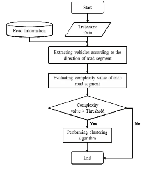
Fig. 2. The procedure of computing
congested routes
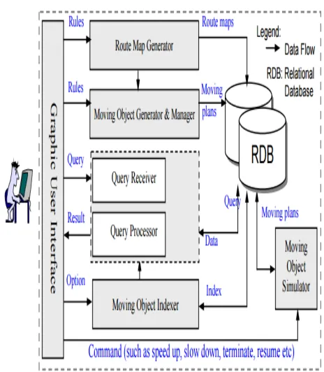
3. DSTTMOD:
The architecture of the DSTTMOD system
we have implemented. The system consists
of five components: Route Map Generator,
Moving Object Generator and Manager,
Moving Object Indexer, Moving Object
Simulator, and Query Processor.
Route Map Generator is responsible for
generating route maps (road networks) on
which moving objects move. There are two
different ways to generate route maps:
generated route map will be stored in the
database.
Moving Object Generator and Manager
generates moving objects according to a
specified route map. The user can choose to
create a moving object either automatically
or manually. Information concerning each
moving object includes an identifier and a
moving plan [13]. The system then
generates the corresponding trajectory
according to the moving plan, which will be
stored in the database.
Moving Object Indexer generates a
spatial-temporal index for the moving objects
managed by the system. In DSTTMOD, we
use a Grid-file based indexing structure
which is called GMOI to index moving
object trajectories. We have made two major
modifications to the original Grid-file based
method [14] in order to reduce location
update costs
Fig. 3. Architecture of the system
Moving Object Simulator is responsible for
simulating the running of moving objects.
During its life time, a moving object can
change its moving plan proactively, and it
may also deviate from the predefined
moving plan due to unforeseeable events
Both cases will trigger location updates. The
system allows users to define parameters
which will then affect the frequency of
location updates and the uncertainty of the
system.
Query Processor can support 3 kinds of
queries concerning past, current, or future
location information. Results of Point
of MO01” can be directly computed from
the trajectories of moving objects. Range
queries and KNN queries can be supported
by the index structure of DSTTMOD. The
system provides a GUI to interact with
querying users.
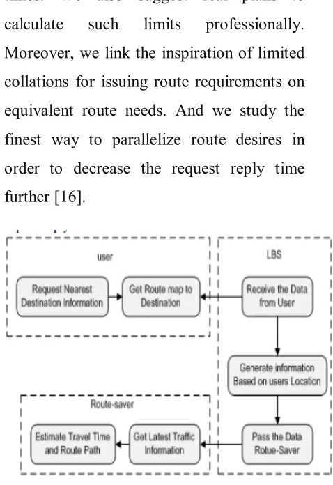
4. PROPOSED SYSTEM
When an individual wish to know target
info based on customer’s obligation say for
sketch user needs to reach near ATM or
hospital. He can get ATM or hospital info
using internet facility wage-earner. However
he needs actual outcome with respect to
travel time and fee[15]. Accordingly
individual desires presentation that
deliveries all of the capability he needs.
Some works effort and ideal the travel times
of street sections as time-various
topographies, which may also be removed
from past traffic designs. These facilities
may just imprisonment the values of
episodic actions they however cannot
reproduce traffic info, which can be
achieved by unexpected actions, e.g.
congestions, accidents and road
maintenance. To decrease the number of
route appeals while providing effectual
outcomes, we syndicate info all over a
couple of routes within the log to originate
close-fitting lessen/higher leaping journey
times. We also suggest real plans to
calculate such limits professionally.
Moreover, we link the inspiration of limited
collations for issuing route requirements on
equivalent route needs. And we study the
finest way to parallelize route desires in
order to decrease the request reply time
further [16].
Figure 4:Agenda for propose work
Based on the above analysis, we adopt a
Grid-file based indexing method, which is
called Grid File based Moving Objects
Index (GMOI for short), to organize the
trajectories of moving objects. The fast
moving speed indicates that the congestion
of the road segment is low. In contrast, the
low moving speed indicates that the
congestion of the road segment is high. The
saturation degree is computed based on the
1. Congested Routes Detection
Algorithm
In this section, we present the algorithm of
congested routes detection. The algorithm
operates in two phases. In the first phase, the
complexity value of each road segment in
the road network according to different
directions is computed. In the second phase,
the congested routes of a road network are
evaluated by clustering the congested road
segments with each time interval. When the
complexity value of a road segment is larger
than the predefined threshold value the road
segment is considered as a congested road
segment. Finally, the congested road
segments with same direction are clustered
together the congested routes detection
algorithm.
Congested routes detection algorithm
Input : - Set of trajectories Tr =
{tr1,tr2,…,trn} - Set of road segments S =
{S1,S2,…,Sk} - Set of time intervals T =
{t1,t2,…,tn} ∈ Tr - Threshold α :
complexity value for determining congested
road segments:
Output: - Set of cluster groups CH =
{CH1,CH2,…,CHn}:
Algorithm:
Initialize CH, candidate list C;
While there exists Tr in road segments list S
Select segment Si in S according to each
direction;
Compute the complexity value v of Si ;
End while
for everyz time interval t ∈ Tr
while there exists Tr in segment list S
foreach segment Si in S
if complexity value v > α
append Si to C;
if there exists neighbor segment N in C
create CH Å append N to candidate list C;
else
create CH Å candidate list C;
end for
end while
end for.
2. Clustering Groups:
The most important problem was attribute
algorithms is very sensitive to the quality of
the attributes. Initially we chose a set of 8
numeric attributes representing ticketing
behavior such as the number of tickets and
ticket events; the number of days on which
tickets were opened, closed, or a ticket event
occurred; and the ticket usage span we
found clustering to be useful, revealing
interesting patterns characterizing the
behavior of the groups and individual
students, when using TRAC. Frequent use of
the 3 media, with high number of active
events (such as ticket update and ticket
accepting, wiki page edits and SVN
commits) is associated with positive
outcomes. Effective group leadership and
monitoring are also linked with positive
outcomes. In future work, we would like to
make a better use of the SVN data as it is an
important data source conveying the “real
work” done by the students in producing
software. We also performed clustering of
the individual students, with the hope that
the group composition would reveal
information that was missed when all
individuals in a group were considered
together. The attributes we selected are
listed in Table 5; they are similar to the ones
in Table 3 but characterize individual not
group activity.
ATTRIBUTES SELECTED FOR
CLUSTERING OF INDIVIDUAL
STUDENTS
-Number of ticket events
-Number of tickets in which the individual
was involved
-Number of different days in which a ticket
event occurred
-Average number of ticket events per active
(individual) ticketing day *
-Number of wiki events
-Number of wiki pages edited
-Number of different days on which a wiki
event occurred
-Average number of wiki events per active
(individual) wiki day
-Average lines added per wiki edit
-Average lines deleted per wiki edit
-Number of SVN commits
-Average number of files per SVN commits
-Number of different days in which an SVN
commit occurred
-Average number of SVN commits per
We ran the clustering using the data only
from the first seven weeks of data and found
that, already, some of these key results had
already emerged. For example, the Group
leader was already showing the developer’s
behaviours. Had the group facilitator been
aware of this, they may have been able to
help this group deal with this problem, early
enough to have made a difference.
5. Performance Evaluation
In this section, we introduce the
performance evaluation by comparing the
proposed scheme with the existing scheme.
Wireless communications is one of the
upgrowing technologies to provide better
communication among people.
Most of the researchers concentrate only
on data transmission but failed to
concentrate on user accuracy.
They were accuracy problem while
providing the data through the networks.
Most wireless transactions are done
through public atmosphere so they were
occurred accuracy problem.
They were problem under accuracy
because of high computational and
communication costs.
LBS support location privacy control by
the user. It supports user control and
scalability
It provides Instant Messaging service for
server and clients.
6. CONCLUSION
We have presented an overview of accurate
and efficient query processing in mobile
networks. With the advancement of mobile
technologies, wireless networks have
become widely available and interconnected
together It extracts the congested road
segments based on the average speed of the
vehicles and the saturation degree of a road
segment. The final congested routes are
computed by performing clustering scheme.
The experimental results showed that the
proposed scheme can discover the congested
routes in different directions over the
existing schemes. Discrete Spatio-Temporal
Trajectory Based Moving Objects Database
(DSTTMOD) model our aim is to support
queries for location information not only in
the past and at present and In the future, we
will conduct more performance evaluation
of our approach by using the real trajectory
data of vehicles.
[1] 2011 Census TIGER/Line Shapefiles.
(2011).
[2] Yu Li and Man Lung Yiu, “Route-Saver:
Leveraging Route APIs for Accurate and
Efficient Query Processing at
Location-Based Services”.
[3] Q. Han, Y. Zhang, X. Chen, H. Li, and
J. Quan, “Efficient and robust identity-based
handoff authentication in wireless
networks,” in Proc. 6th Int. Conf. Network
and System Security, Fujian, China, 2012,
pp. 180–191, LNCS 7645.
[4]
http://www.educationaldatamining.org/event
s.html, Educational Data Mining Events,
2008.
[5] A. Merceron and K. Yacef, "Clustering
Students to Help Evaluate Learning," in
Technology Enhanced Learning, vol. 171,
J.-P. Courtiat, C. Davarakis, and T.
Villemur, Eds.: Springer, 2005, pp. 31-42.
[6] J. I. Won, S. W. Kim, J. H. Baek and J.
H. Lee, “Trajectory Clustering in Road
Network Environment,” in Proceedings of
IEEE Computational Intelligence and Data
Mining, pp. 299-305, 2009
[7] G. P. Roh, J. W. Roh, S. W. Hwang and
B. K. Yi, “Supporting Pattern Matching
Queries over Trajectories on Road
Networks,” IEEE Transactions on
Knowledge and Data Engineering, vol. 23,
no. 11, pp. 1753-1758, 2011
[8] Z. Chen, H. S. Shen and X. Zhou,
“Discovering Popular Routes from
Trajectories,” in Proceedings of IEEE Data
Engineering, pp. 900-911, 2011
[9] X. Li, J. Han, J. Lee and H. Gonzalez,
“Traffic Density-Based Discovery of Hot
Routes in Road Networks,” in Proceedings
of SIAM International Conference on Data
Mining, pp. 441-459, 2007
[10] V. Tyagi, S. Kalyanaraman and R.
Krishnapuram, “Vehicular Traffic Density
State Estimation Based on Cumulative Road
Acoustics,” IEEE Transactions on
Intelligent Transportation Systems, vol. 13,
no. 3, pp. 1156-1166, 2012.
[11] Wolfson O., Chamberlain S., Dao S.,
Jiang L., Location Management in Moving
Objects Databases. In Proceedings of
WOSBIS’97, Budapest, Hungary, Oct. 1997
[12] M. Arjun and K.Sirisha, “Live Activity
List Based Shortest Path Calculation”,
IEEE, Vol. 2,No.9, 2015.
[13] Saltenis S., Jensen C. S., Leutenegger
Continuously Moving Objects. In Proc. of
ACM SIGMOD 2000, Dallas, TX, USA,
2000.
[14] J. Nievergelt, H. Hinterberger, and K.
C. Sevcik, The grid file: An adaptable,
symmetric multikey file structure, ACM
Trans. on Database Sys. 9(1), 1984:38-71.
[15] R.Subashini and A.JeyaChristy,
“Online Shortest Path based on Live Traffic
Circumstances” Vol. 3, No.11, 2014.
[16] DekondaSindhuja, R Vasavi and A
KousarNikhath, “Online shortest path
computation using Live Traffic index”, Vol.