Electronic Thesis and Dissertation Repository
11-4-2016 12:00 AM
Channel Form and Processes in a Formerly Glaciated Terrain
Channel Form and Processes in a Formerly Glaciated Terrain
Nathaniel Bergman
The University of Western Ontario
Supervisor
Marco Van De Wiel
The University of Western Ontario
Graduate Program in Geography
A thesis submitted in partial fulfillment of the requirements for the degree in Doctor of Philosophy
© Nathaniel Bergman 2016
Follow this and additional works at: https://ir.lib.uwo.ca/etd
Part of the Geology Commons, Geomorphology Commons, Geotechnical Engineering Commons, Glaciology Commons, Hydraulic Engineering Commons, Hydrology Commons, Natural Resources and Conservation Commons, Natural Resources Management and Policy Commons, Sedimentology Commons, Stratigraphy Commons, and the Water Resource Management Commons
Recommended Citation Recommended Citation
Bergman, Nathaniel, "Channel Form and Processes in a Formerly Glaciated Terrain" (2016). Electronic Thesis and Dissertation Repository. 4332.
https://ir.lib.uwo.ca/etd/4332
This Dissertation/Thesis is brought to you for free and open access by Scholarship@Western. It has been accepted for inclusion in Electronic Thesis and Dissertation Repository by an authorized administrator of
Despite that many places around the world in general, and North America in particular, were glaciated during the last ice age, relatively little is known about rivers that evolved over glaciated landscapes once they deglaciated. They are commonly categorized as alluvial with a glacial legacy, and often described as simple gravel-bed or sand-bed rivers. Alternatively, they are classified as bedrock rivers because the glacial deposits have been eroded and the underlying rock is exposed. However, the glacial history of these rivers is important and my research shows that classification for them is "semi-alluvial". This work shows that classification is important, not only for scientific accuracy but for river management that must be based on a sound understanding of river form and process. Poor understanding can be costly (i.e. restoration and management that do not achieve their goals; failed infrastructure), leading to wasted resources and inefficient functioning of the river.
Two major geomorphologic phases can be discerned in formerly glaciated terrains:
Deglaciation which exposed the landscape to erosion when ponded meltwater was abundant and led to outburst flooding. These catastrophic floods cannot occur under the modern climate of southern Ontario. Evidence for glacial lakes is found in lacustrine deposits upstream, and on top of moraines while spillways indicate where glacial lakes drained and carved deep valleys into the terrain. Spillways reveal outburst flooding with boulder lags, terraces, flow scars and possibly mounds and berms away from the modern misfit channel.
Postglacial incision and deposition during a single flood event or a single hydrological year. Human disturbance over the past two centuries, includes agriculture, channelization, millponds and weirs.
The dissertation addresses two parallel paradigms in fluvial geomorphology: Which processes are responsible for most of the geomorphic work that shapes the landscape - catastrophic flood(s) or small-scale erosion and deposition that bit by bit give the channel and valley its present morphology? My work will show that the outburst flooding of Glacial Lake London (paper 1) sets the stage for the postglacial morphology and small-scale processes we see today (paper 2). The third paper attempts to explain these small-scale processes using a 1D hydraulic model that can answer dynamic questions like bankfull discharge, water surface slopes of discharges, and velocity reversal hypothesis.
This thesis contains three manuscripts. The first manuscript is entitled: "The drainage of the last
Glacial Lake London, Ontario: Mapping and hydraulic modeling". This manuscript is
co-authored with Marco Van De Wiel (supervisor), Steve Hicock (supervisor) and Yannick
Rousseau (fellow PhD student). I conducted all fieldwork, data collection and analysis and wrote
the paper under the supervision of Marco Van De Wiel and Steve Hicock who provided insight
into the modeling and various glacial processes. Yannick Rousseau helped with the technical
aspects of GIS work, assistance in Komoka Provincial Park and discussed aspects of the paper.
The second manuscript is entitled: “Semi-alluvial stream channel crossing the interlobate Arva
Moraine, Medway Creek, southern Ontario, Canada. 1: Sedimentary characteristics and
morphologic change”. This manuscript is co-authored with Marco Van De Wiel (supervisor) and
Steve Hicock (supervisor). I conducted all fieldwork, data collection and analysis and wrote the
paper under the supervision of Marco Van De Wiel and Steve Hicock who provided insight into
the various glacial processes, and helped reviewing and editing the manuscript. Marco Van De
Wiel provided funding. Steve Hicock also provided logistical support for sieving of river bed
gravels and interpretation of the local tills and glacial deposits.
The third manuscript is entitled: "Semi-alluvial, till-bedded stream channel crossing an
interlobate moraine in Southern Ontario, Canada. 2: Morphometry, hydrology and hydraulics of
Medway Creek". This manuscript is co-authored with Marco Van De Wiel (supervisor) and
Steve Hicock (supervisor). I conducted all fieldwork, data collection and analysis and wrote the
paper under the supervision of Marco Van De Wiel and Steve Hicock who provided insight into
the various modeling phases, and helped reviewing and editing of the manuscript.
I will be the first author on all three publications. All paper are planned to be published in the
near future. The first in a special GSA Special Paper about paleofloods while the other two in
Dedication
For my parents, Hannah and Adam Bergman
First and foremost, I would like to express my sincere gratitude to Dr. Marco Van De Wiel and
Dr. Steve Hicock who were a positive influence on this project when it seemed that it was not
going to materialize after encountering significant academic difficulties. Marco always
challenged me to find the best solutions to any field-encountered or modeling problems while
Steve provided a perspective on glacial processes and always knew where to find the right source
or person with an answer.
I’m indebted to Dr. Katrina Moser for her belief in me when progress was sluggish and pushing
me forward, first as department graduate chair, later in many personal talks about lakes, rivers
and climate in the department and as an integral part after joining my advisory committee. Dr.
Adam Yates gave interesting perspectives about rivers I had not thought of and I also appreciate
his time and effort as part of my advisory committee. Yannick Rousseau, my friend, office mate,
field mate and expert technical advisor on GIS and modeling was instrumental in making large
leaps in all stages of work. My external reviewers Dr. Joe Desloges and Dr. Guy Plint together
with my internal reviewer Dr. James Voogt improved the work significantly after my defense.
Dr. Bob Jarrett advised me on Manning’s roughness and has been a huge support ever since I
started my PhD. Dr. Jim O’Connor of the USGS Portland provided the data of moraine-dammed
lakes. Dr. Dan Shrubsole, department chair, I thank you all for your support and advice over the
years. Belinda Dodson is thanked for interesting conversations. To Dr. Peter Ashmore for initial
ideas about Medway Creek.
Lori Johnson, the department's graduate administrator, was my rock in all matters, personal, academic and was my best advisor and support of how to tackle all matters in Canadiana. Caroline Majeau, Suzanne Dudzic, Barbara Thomas and Lelanya Milley helped me to handle endless bureaucracy that I’m terrible in dealing with. Erika Hill was helpful on many technical matters and lab analyses. Karen Van Kerkoerle drew and improved most figures. Joe Smrekar helped on various computing issues. Tim Marchand, Melody Cairns and Rhonda Card of Ontario Parks provided the permission to work in Komoka Provincial Park. Kimi Maruoka was a huge help on many technical issues and a great friend.
Abstract ii
Co-Authorship statement iii
Dedication iv
Acknowledgments v
Introduction 1
Background 12
Research Questions 16
Thesis Structure 16
References 18
Paper 1: Drainage of the last Glacial LakeLondon, Ontario: Mapping and hydraulic modeling 20
Paper 2: Semi-alluvial stream channel crossing the interlobate Arva Moraine, Medway Creek, Southern Ontario, Canada. 1: Sedimentary 2 characteristics and morphologic change 85
Paper 3: Semi-alluvial till-bedded stream channel crossing an interlobate moraine in Southern Ontario, Canada. 2: Morphometry, hydrology and hydraulics of Medway Creek 169
Conclusions 221
Brief glacial history of southern Ontario and its landforms
Southern Ontario is part of the gentler lowlands of the Great Lakes and St.
Lawrence River, underlain by Paleozoic sedimentary rocks. The Laurentide Ice Sheet
completely covered southern Ontario twenty thousand years ago at the last glacial
maximum (LGM). This continental glacier complex covered most of Canada (80%)
and extended into the northern states of the United States. The Wisconsinan glaciation
began approximately 115,000 years BP and ended about 10,000 years BP. The
Wisconsinan is divided into three major parts: Early, Middle and Late Wisconsinan.
The Early Wisconsinan (115,000 - 60,000 years BP) marks the inception and growth
of the Laurentide Ice Sheet coupled with a cooling climate. The Middle Wisconsinan
(60,000 - 30,000 years BP) was warmer and southern Ontario was essentially ice-free.
During the Late Wisconsinan (30,000 – 10,000 years BP) southern Ontario was
ice-covered again with many advances and retreats of the ice lobes. Ice flow was
controlled by the broad topographic depressions of the Great Lakes basins. Lobes of
ice extending beyond the main body of the ice sheet developed in these basins and
acted at times independently in response to local conditions at the base of the glacier
rather than, or in addition to, climatic change. By 15,000 years BP the Laurentide Ice
Sheet front started its final retreat from southern Ontario. While the Late Wisconsinan
glaciation is the last time southern Ontario was completely glaciated, other earlier
glaciations during the Quaternary Period as well as during the Precambrian covered
the region but their geologic records are incomplete due to erosional processes as
unconsolidated rock debris deposited during the last glaciation when the Laurentide
Ice Sheet occupied the region (Fig. 1). The tills are composed of unsorted mixture of
clay, sand and gravel. The tills are spread over the landscape in a relatively flat terrain
or sometimes molded into gentle hills called drumlins. Where the ice made temporary
halts or re-advances, the till was pushed into long, rough ridges and sometimes
covered with sand and gravel. These areas of rough topography are end moraines and
are the most common high-relief landform of the region. The moraines are often
breached by modern rivers and these breaches are either a result of a glacial spillway
channel or post-glacial incision. The spillway channels carried drainage from the
melting ice and today's modern rivers flowing through them are clearly smaller,
making them underfit or misfit channels. Other glacial features of the region are long,
narrow ridges of sand and gravel termed eskers and irregularly-shaped gravel hills
called kames (Putnam and Kerr, 1966).
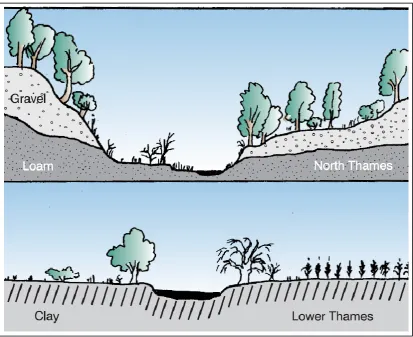
tributary Medway Creek, can be easily divided into two physiographic parts: 1. The
upper watershed which is predominantly composed of till moraines, till plains and
many dissecting spillway channels. 2. The lower watershed southwest of London all
the way to Lake St. Clair outlet that is composed mainly of clay, sand and till plains
(Fig. 2.). The transition point between the two watershed parts (around Delaware on
the map) is a large spillway channel that drained the London Basin (through Glacial
Lake London) and will be the focal point of the deglaciation process this work
describes in the first manuscript. The marked differences in landforms are also
expressed in the Thames River valleys' morphology as the upper watershed is
generally deeply incised compared to the lower subdued basin (Fig. 3).
Figure 3. Typical cross-sections of the upper Thames River valley (top) and the lower Thames River valley (bottom) showing marked difference in topography (Upper Thames Conservation Authority, 1999).
While the tills were formed and deposited during glacial advance or retreat, the ice
lobes generated considerable volumes of meltwater. There was a cyclical annual
production of meltwater: summer release of water stored during the fall, winter and
spring months but there was also a diurnal summer cycle release which was
associated with rising day temperatures and cooler night temperatures. The diurnal
cycles were less important in a large continental ice sheet like the Laurentide Ice
Sheet as their water volumes were much smaller. The meltwater was either ponded in
lakes close to the ice margins or flowed into streams and rivers draining away from
the ice mass. The meltwater carried with them large quantities of sediments into the
local rivers (glacio-fluvial outwash deposits) and lakes (glacio-lacustrine and
The field of paleoflood hydrology (i.e. ancient flood reconstruction) is strongly
linked to an historic divergence between two opposing paradigms originating in 19th
Century geology: uniformitarianism vs. catastrophism. Most scientists believed that
processes in nature and associated landscape evolution are very slow (100s-1000s of
years); erosional processes gradually remove sediments and denude the land into the
present-day landscape and these processes are identical through time. Prominent
geologists like Charles Lyell and James Hutton supported uniformitarianism and this
also helped Charles Darwin articulate the revolutionary biological evolution of the
origin of species in 1859. In contrast, scientists like Georges-Louis Leclerc, Comte de
Buffon and later Georges Cuvier and Joseph Fourier argued that Earth underwent a
series of short-term natural sudden catastrophic events (scale of a few minutes to days
or months) such as violent volcanic eruptions, floods and other upheavals that shaped
the landscape but these ideas were less common and often rejected (Baker, 1998).
These two paradigms clashed in fluvial geomorphology when J. Harlan Bretz
suggested in the 1920s the Channeled Scabland of Eastern Washington was a result of
a massive cataclysmic flood. The fact that Bretz had no water source to corroborate
these findings and his discovery relied on peculiar landforms met intense criticism
from the geologic community that was strongly entrenched in uniformitarianism
ideas. Only when USGS scientist Joseph T. Pardee published his findings about
Glacial Lake Missoula drainage in 1945, cataclysmic floods were accepted by the
geologic community as an important geomorphic agent shaping the landscape almost
instantaneously. Later, megaflood evidence was found in other breached lakes (i.e.
Altai floods in Siberia, Bonneville Flood in Idaho, ancestral Great Lakes and Glacial
compared to modern-day flood deposits or erosion? The first striking feature about an
unusual flood is that it might leave behind a spillway morphology and misfit channel,
(Kehew and Lord, 1986) that seem uncommon for the local river hydrology to create
during ordinary floods, usually overbank flows that occur during the lifespan of
humans (i.e. 10-100 years). Secondly, there are deposits or erosion scars high above
the present-day river and it is quite evident that they originate from a fluvial process
and not a hillslope or glacial process. Furthermore, if the river is gauged it is possible
to associate modeled peak discharges with deposits/erosion remnants and check
whether their elevations match. Paleoflood Geomorphologists divide these
deposits/erosion remnants into two: Slack water deposits (SWDs; Patton et al., 1979)
and Paleo stage indicators (PSIs; Jarrett, 1990). SWDs are sandy sediments that are in
suspension during a large flood and deposit in dead zones or in localities which flow
velocity decreases (i.e. caves, crevasses, tributary confluences and other irregular
bank/river valley topography). PSIs are a variety of depositional/erosional features
such as erosion scars, terraces, benches, boulder bars and boulder lags that mark a
minimum level of the paleo-flow, usually far from the present-day channel and
coupled with their large scale are ordinarily preserved for a long time after the flood
occurrence (Costa, 1983). The hydraulic engineering community, which at first
completely rejected paleoflood hydrology, adopted the methodology of the field and
often uses these techniques to predict (hazard risk assessment) or reconstruct
dam-break floods coupled with development of extensive parametric breaching equations
that are based on physical characters of the reservoir stored behind the dam.
Consequently, paleoflood hydrology is not only a mature scientific sub-discipline of
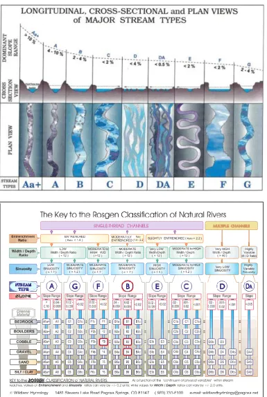
In order to define stream types, geomorphologists seek to characterize rivers
usually according to their general morphology on a variety of scales. The
classification allows assessing the channel morphology, organizing information about
specific types as a framework, detecting change over time, comparing to other rivers
and in many cases allowing determination of what a healthy or impaired river is
(Kondolf et al., 2003). The earliest and simplest classification was suggested by
Leopold et al. (1964) and that included straight, meandering, braided and
anastomosing morphological patterns. Later classifications are more complex relating
to the supply of sediment and bedforms. For example, the often-used Montgomery
and Buffingtons' classification (1997) for mountain rivers relates to the substrate the
channel is made of and the associated bedforms (Fig. 4).
Figure 4. The Montgomery and Buffington (1997) channel classification for mountain rivers with relations to bedforms, transport capacities and sediment supply.
The main problems of most channel classifications are that they usually ignore
processes and are thus very simplistic or that their developers worked in a specific
region and consequently they cannot be generalized to other localities or
environments. For example, the controversial Rosgen (1994, 1996) classification (Fig.
5; also termed Natural Channel Design - NCD), that is presenting very detailed
practitioners community enthusiastically adopted this comprehensive classification
scheme.
that channels within a basin can be several types of rivers even at the same time
according to changing topography, changes in geology and in the last couple of
centuries land use changes, climate change and hydrology imposed by humans.
Furthermore, all channel classifications published to date (2016) do not include
semi-alluvial rivers. These rivers have some kind of geologic constraint (explained in
manuscript two) and it would therefore be difficult to categorize them properly
without a new category. For example, Martini (1977) and O'Connor et al. (1986)
describe bedrock channels with well-developed alluvial bedforms. Looking back at
Fig. 4 on the Montgomery and Buffington classification shows that bedrock rivers are
not supposed to have bedforms in the first place and are expected to be devoid of
alluvium - just plain bedrock. The second and third manuscript of this work show that
a semi-alluvial river in a formerly glaciated terrain (Medway Creek) is a hybrid
between alluvial rivers and bedrock rivers and together with the relatively little
material published about this river type can be classified on its own. Phillips and
Desloges (2014; 2015a) and Thayer et al. (2016) recently demonstrated the
contemporary glacial conditioning of several southern Ontario till rivers and there
were also recent attempts to classify them according to their floodplain (Phillips and
Desloges, 2015b; Thayer and Ashmore, 2016). Our research adds to these studies by
using a variety of hydrological and sedimentological indices often used in river
studies both in academia and practicum of management and restoration.
Both the long-term instantaneous erosion (i.e. dam-break catastrophism during
deglaciation) and contemporary short-term form and erosion processes (i.e.
uniformitarianism) generate a continuum of a deglaciating landscape evolution and
Baker, V.R., 1998. Catastrophism and uniformitarianism: logical roots and current relevance in geology. In: Blundell, D.J. and Scott, A.C. (Eds.) Lyell: the Past is Key to the Present. Geological Society, London, Special Publications, 143, 171-182.
Baker, V.R., 2003. A bright future for old flows: origins, status and future of
paleoflood hydrology. In: Thorndycraft, V.R. Benito, G. Barriendos, M. and Llasat, M.C. (Eds.) Palaeofloods, Historical Floods and Climatic Variability: Applications in Flood Risk Assessment, Proceedings of the PHEFRA Workshop, Barcelona, 16-19th October, 2002, Chapter 2, 13-18.
Barnett, P.J., 1992. Quaternary Geology of Ontario. In: Thurston, P.C., Williams, H.R., Sutcliffe, R.H., Stott, G.M. (Eds.) Geology of Ontario. Ontario Geological Survey, Special Volume 4 part 2, Chapter 21, 1011-1088.
Costa, J.E., 1983. Paleohydraulic reconstruction of flash-flood peaks from boulder deposits in the Colorado Front Range. Geological Society of America Bulletin 94, 986-1004.
Jarrett, R.D., 1990. Paleohydrologic techniques used to define the spatial occurrence of floods. Geomorphology 3, 181-195.
Kehew, A.E., Lord, M.L., 1986. Origin and large-scale erosional features of glacial-lake spillways in the northern Great Plains. Geological Society of America Bulletin 97, 162-177.
Kondolf, G.M., Montgomery, D.R., Piegay, H., Schmitt, L., 2003. Geomorphic classification of rivers and streams. In: Kondolf, G.M. Piegay, H. (Eds.) Tools in Fluvial Geomorphology, Wiley, pp. 171-204.
Leopold, L.B., Wolman, M.G., and Miller, P., 1964. Fluvial Processes in Geomorphology. W.H. Freeman and Company, 522 p.
Martini, I.P., 1977. Gravelly flood deposits of Irvine Creek, Ontario, Canada. Sedimentology 24, 603-622.
Montgomery, D.R., Buffington, J.M., 1997. Channel reach morphology in mountain drainage basins. Geological Society of America Bulletin 109, 596-611.
O'Connor, J.E., Webb, R.H., Baker, V.R., 1986. Paleohydrology of pool-and-riffle pattern development: Boulder Creek, Utah. Geological Society of America Bulletin 97, 410-420.
O’Connor, J.E., Clague, J.J., Walder, J.S., Manville, V., Beebee, R.A., 2013. Outburst floods. In: Shroder, J. (Ed.) Treatise on Geomorphology. AP, San Diego, 475-510.
Patton, P.C., Baker, V.R., Kochel, R.C., 1979. Slack water deposits: a geomorphic technique for the interpretation of fluvial paleohydrology. In: Rhodes, D.D., Williams, G.P. (Eds.), Adjustments of the Fluvial System. Kendall/Hunt Publishing, Dubuque, IA, 225-253.
Phillips, R.T.J., Desloges, J.R., 2014. Glacially conditioned specific stream powers in low-relief river catchments of the southern Laurentian Great Lakes. Geomorphology 206, 271-287.
Phillips, R.T.J., Desloges, J.R., 2015a. Alluvial floodplain classification by multivariate clustering and discriminant analysis for low-relief glacially conditioned river catchments. Earth Surface Processes and Landforms 40,
southern Laurentian Great Lakes. Journal of Great Lakes Research 41, 951-964.
Putnam, D.F., Kerr, D.P., 1966. Physical Geography of Southern Ontario. In: A Regional Geography of Canada, J.M. Dent and Sons, Toronto, Chapter 8, pp. 185-200.
Rosgen, D.L., 1994. A classification of natural rivers. Catena 22, 169-199.
Rosgen, D.L., 1996. Applied River Morphology. Wildland Hydrology, Pagosa Springs, CO.
Simon, A., Doyle, M., Kondolf, M., Shields, F.D., Rhoads, B., McPhillips, M., 2007. Critical evaluation of how the Rosgen classification and associated “Natural Channel Design” methods fail to integrate and quantify fluvial processes and channel response. JAWRA Journal of the American Water Resources Association 43, 1117-1131.
Thayer, J.B., Ashmore, P., 2016. Floodplain morphology, sedimentology, and development processes of a partially alluvial channel, Geomorphology 269, 160-174.
Thayer, J.B., Phillips, R.T.J, Desloges, J.R., 2016. Downstream channel adjustment in a low-relief, glacially conditioned watershed. Geomorphology 262, 101-111. Upper Thames Conservation Authority. 1999. Glaciers shape the land. Thames
Current erosion rates of 19 Ontario rivers (most of them in southern Ontario with
drainage areas of 3-4000 km2) are low: between 0.117 and 0.200 tons km-2 yr-1
(average of 0.15 tons km-2 yr-1) (Church et al., 1999) suggesting contemporary fluvial
stability. There are at least three mechanisms that could explain the formation of these
valleys: 1. Gradual post-glacial incision where a new drainage network developed
within the glacial deposits. 2. These valleys existed before glaciation with an existing
drainage network, were completely filled, buried and covered by ice during the
Laurentide Ice Sheet (LIS) and once they deglaciated and became exposed again,
fluvial erosion resumed. 3. Some of the valleys are spillway channels either formed
on the edge of the ice lobes as tunnel channels or are a result of catastrophic glacial
lake drainage.
Phillips and Robert (2005) have associated river valley evolution in the Humber
River (a tributary of Lake Ontario in the Toronto area) as post-glacial incision
following the end of the last glaciation (15-13 Ka 14C). Subsequently the Humber
valley aggraded once its base level rose (~ 6.5 Ka BP) and vertical aggradation has
been the dominant mode of floodplain formation in the Humber during the past 4000
years. Lateral channel migration was unlikely because rising base level would have
reduced the amount of energy available for channel shifting (Weninger and
McAndrews, 1989). For example, Arbogast et al. (2008), working in the Muskegon
River in Michigan (a tributary of Lake Michigan that was deglaciated ~ 16Ka BP),
found four post-glacial river terraces that they related to downcutting as a response to
a reduction in flow magnitude (the flow geometry was more concentrated). In
south-central New York, Scully and Arnold (1981) studied the Unadilla River and the
adjustment to an increase in channel slope caused by postglacial isostatic uplift of the
region. Both examples are of till-bedded rivers.
A second mechanism of an incised valley’s formation is inheritance of pre-glacial
drainage. Several studies suggested that modern rivers of the Great Lakes are imposed
on ancient bedrock rivers that are now buried under glacial sediments and are
therefore ‘tectonically predesigned’ (Eyles et al., 1997; Lajeunesse, 2014). The
Thames River (the river of this study and Medway Creek is one of its tributaries) does
not exist in Grabau (1901), Spencer (1890; 1907), Karrow (1973), Flint and Lolcama
(1986) and Gao (2011) studies that reconstructed the regional (bedrock) drainage of
southern Ontario during glaciation, while today’s modern Thames channel flows into
Lake St. Clair. Spencer (1907) and later Flint and Lolcama (1986) located the
London, Ontario, area between the pre-glacial Erigan River to the south and the
Laurentian River to the north. According to Dreimanis et al. (1998), postglacial
modern stream courses follow or are blocked by end moraines that determine their
present paths. This supports the findings of Hack (1965) in Michigan that claimed the
streams of Glacial Lake Duluth (now Lake Superior) followed existing glacial
grooves that extended downslope towards the lake. In the much steeper bedrock
terrains of the Swiss Alps, Montgomery and Korup (2010) suggested that despite
repeated glaciations, the valleys are preserved and the topography does not start the
incision again after each glaciation ends as it is persistent over time.
The third possible mechanism for the formation of incised river valleys is that they
are catastrophic spillway channels (see Kehew et al., 2012 for a comprehensive
review). Chapman and Putnam (1984) mapped many of the local rivers of southern
lakes that then breached underneath the unconsolidated glacial material and ice sheets.
The works of Shaw and Gilbert (1990) and Brennand and Shaw (1994) in southern
Ontario support this mechanism of river valley creation. This interpretation of central
southern Ontario tunnel channels is consistent with the view that the subglacial
landsystem (drumlins, valleys and s-forms) was eroded by a regional meltwater
underburst - the Algonquin event - that unsteadily evolved from sheet to a single vast
channelized flow (e.g. Shaw and Gilbert, 1990). As fan deposits are not observed at
the ends of channels it is likely that channel formation was contemporaneous with an
underburst event that eroded drumlins in Lake Ontario and swept away most sediment
derived from channel erosion. Ice sheet thinning and flattening associated with
underbursts facilitated deglaciation by regional downwasting and stagnation
(Brennand et al., 2007). This third mechanism of valley formation stands alone from
the other two as it implies almost instant shaping of the topography and it brings up
the argument that catastrophic flood events (cataclysms) dominate the landscape
(Baker, 1977; Wolman and Gerson, 1978) over the smaller - medium events that do
much less geomorphic work but are more frequent (Wolman and Miller, 1960).
According to Costello and Walker (1972), who worked on the sedimentology of
the Credit River (Niagara Escarpment, Lake Ontario drainage), the post-glacial rivers
of the area initially resembled braided outwash streams. As sediment amounts
decreased and channels began to stabilize they achieved a single-thread channel form
filling the outer valley and the braids that became their floodplain. This initial channel
evolutionary stage fits the first two forming mechanisms described above but not the
third that suggests almost instantaneous formation of the glacial valleys. Rivers
the American Midwest as these areas of the Mid-Atlantic (Pennsylvania) were not
glaciated during the Wisconsinan. However, there is evidence of Holocene accretion
of floodplains on the Grand River (Lake Erie drainage, see Walker et al., 1997) and
Thames River (Stewart and Desloges, 2014) that were used by the native population
for settlements and agriculture. From these previous studies it is clear that different
perspectives exist on the evolution of the post-glacial fluvial landscape in southern
Ontario. What is not clear, however, is how these different perspectives can be
reconciled or how early post-glacial processes and contemporary processes combine
in creating the contemporary fluvial geomorphology of southern Ontario.
This work will investigate the London Ontario area from various fluvial
perspectives. The work is divided into three parts in a paper format. While each paper
can stand alone, together they give a comprehensive picture of how rivers in the area
evolved during two of the most dramatic geomorphic periods: 1. During the end of the
ice age when the region first deglaciated and meltwater and remaining glacial
sediments first interacted as fluvial processes (as opposed to earlier glacial processes);
and 2. In recent times, under present-day fluvial processes following the
British-European Colonial era that drastically modified the landscape by clearcutting of dense
forests, draining wetlands, artificially channeling small tributaries and turning them
into a vast agricultural and urban setting. The intervening period was less dramatic as
braided outwash streams filled and turned into single-thread channels (Costello and
Specifically, this thesis seeks to answer the following research questions:
1. Do fluvial systems in the London area result from catastrophic floods or are
today's frequent small to medium floods the main drivers of landscape
evolution?
2. Do the geomorphic characteristics and dynamics of fluvial systems incised in
tills differentiate them from alluvial rivers and bedrock rivers?
3. Are channel bed stability metrics originally developed for alluvial rivers
suitable for use in till-bedded channels?
Thesis structure
The thesis is made up of three core papers. The first paper titled "The drainage of
the last Glacial Lake London, Ontario: Mapping and hydraulic modeling" describes
the London area during deglaciation, reconstructs Glacial Lake London minimum and
maximum extents and its catastrophic drainage into what is today's Komoka
Provincial Park and the Caradoc Delta using conventional paleoflood techniques.
Paper 2 titled "Semi-alluvial till-bedded stream channel crossing the interlobate Arva
Moraine, Medway Creek, Southern Ontario, Canada. 1: Sedimentary characteristics
and morphologic change" shows that small rivers incised into till are different than
ordinary alluvial rivers and resemble more soft bedrock-controlled channels with
differing spatial and temporal bed erosion rates. A thin alluvial cover with varying
sedimentology overlies the till within unorganized bedforms. The third paper titled
"Semi-alluvial till-bedded stream channel crossing an interlobate moraine in Southern
low, medium to high flow hydrology and simulated by 1D hydraulic modeling.
Channel morphometry and hydrologic characteristics are compared to similar
semi-alluvial rivers as well as to rivers with semi-alluvial and bedrock channels. They illustrate
that current classification, understanding, management and restoration of these rivers
is lacking or flawed and that more research is needed to establish a reliable body of
knowledge about them.
Research on semi-alluvial rivers in general, and a till-bedded channel in particular,
goes beyond the scientific interest of river studies: it has social and economic
implications as these types of terrains continue to be exposed under a rapidly warming
climate in glaciated regions. These implications include active management and
restoration of these rivers and placing housing development and infrastructure on their
channel/floodplain/river valley.
While the work is area-specific, its inferences apply to many areas in North
America that were affected by ice lobes (such as the US Midwest, US North Atlantic
states, Great Lakes, Northern Great Plains) and other places around the world that
deglaciated when the ice age ended, but also areas that are currently deglaciating due
to anthropogenic climate change. The work is comparative and has examples from
similar studies and other river types to show that these fluvial settings with glacial
legacies need to be separated and distinguished from the classic alluvial-bedrock
channel classifications that either ignore them or view them as alluvial or bedrock
Arbogast, A.F., Bookout, J.R., Schrotenboer, B.R., Lansdale, A., Rust, G.L., Bato, V.A., 2008. Post-glacial fluvial response and landform development in the upper Muskegon River valley in North-central Lower Michigan, U.S.A. Geomorphology 102, 615-623.
Baker, V.R., 1977. Stream channel response to floods with examples from central Texas. Geological Society of America Bulletin 88, 1057-1071.
Brennand, T.A., Shaw, J., 1994. Tunnel channels and associated landforms, south central Ontario: their implications for ice-sheet hydrology. Canadian Journal of Earth Sciences 31, 505-522.
Brennand, T.A., Russell, H.A.J., Sharpe, D.R., 2007. Tunnel channel character and evolution in central southern Ontario. In: Knight, P.G., (Ed.) Glacier Science and Environmental Change. Blackwell Publishing, Malden, MA, USA, Chapter 6.
Campo, S.H., Desloges, J.R., 1994. Sediment yield conditioned by glaciation in a rural agricultural basin of southern Ontario, Canada. Physical Geography 15, 495-515.
Chapman, L.J., Putnam, D.F., 1984. Physiography of Southern Ontario. University of Toronto Press, Toronto, Ontario, Canada.
Church, M., Hamm, D., Hassan, M., Slaymaker, O., 1999. Fluvial clastic sediment yield in Canada: scaled analysis. Canadian Journal of Earth Sciences 36, 1267-1280.
Costello, W.R., Walker, R.G., 1972. Pleistocene sedimentology, Credit River, Southern Ontario: A new component of the braided river model. Journal of Sedimentary Petrology 42, 389-400.
Dreimanis, A., Winder, C.G., Aaltonen, R.A., 1998. London Ontario: Geology, geomorphology, geodata. In: Karrow, P.F. and White, O.L. (eds.) Urban Geology of Canadian Cities. Geological Society of Canada Special Paper 42, 237-260.
Eyles, N., Arnaude, E., Scheidegger, A.E., Eyles, C.H., 1997. Bedrock jointing and geomorphology in southwestern Ontario: an example of tectonic predesign. Geomorphology 19, 17-34.
Flint, J.J., Lolcama, J., 1986. Buried ancestral drainage between Lakes Erie and Ontario. Geological Society of America Bulletin 97, 75-84.
Foster, G.E., 1998. Morphology of three semi-alluvial stream channels in southern Ontario. Unpublished Masters Thesis. The University of Western Ontario, 215 pp.
Gao, C., 2011. Buried bedrock valleys and glacial and subglacial meltwater erosion in southern Ontario, Canada. Canadian Journal of Earth Sciences 48, 801-818.
Grabau, A.W., 1901. Guide to the geology and paleontology of Niagara Falls and vicinity. N.Y. State Museum Bulletin 45, 1-284.
Hack, J.T., 1965. Postglacial drainage evolution and stream geometry in the Ontonagon area, Michigan. USGS Professional Paper 504-B.
Karrow, P.F., 1973. Bedrock topography in southwestern Ontario: a progress report. Geological Society of Canada 25, 67-77.
Quaternary glaciations beneath the eastern Laurentide Ice Sheet. Geological Society of America Bulletin 126, 447-458.
Merritts, D., and 27 authors., 2011. Anthropocene streams and base-level controls from historic dams in the unglaciated mid-Atlantic region, USA. Philosophical Transactions of the Royal Society A 369, 976-1009.
Montgomery, D.R., Korup, O., 2010. Preservation of inner gorges through Alpine glaciations. Nature Geoscience4, 62-67.
Phillips, R.T.J., Robert, A., 2005. River incision in relation to post-glacial events in the Humber River basin, Ontario. Géographie physique et Quaternaire 59, 17-30.
Phillips, R.T.J., Desloges, J.R., 2014. Glacially conditioned specific stream powers in low-relief river catchments of the southern Laurentian Great Lakes. Geomorphology 206, 271-287.
Scully, R.W., Arnold, R.W., 1981. Holocene alluvial stratigraphy in the upper Susquehanna River basin, New York. Quaternary Research 15, 327-344.
Shaw, J., Gilbert, R., 1990. Evidence for large-scale subglacial meltwater flood events in southern Ontario and northern New York State. Geology 18, 1169-1172. Spencer, J.W., 1890. Origin of the basins of the Great Lakes of America. Quaternary
Journal Geological Society of London 46, 523-533.
Spencer, J.W., 1907. Falls of the Niagara: Their evolution and varying relations to the Great Lakes; characteristics of the power and effects of its diversion: Canada. Geological Survey of Canada Publication 970, 490 p.
Stewart, A.M., Desloges, J.R., 2014. A 9000-year record of vertical and lateral accretion on the floodplain of the lower Thames River, southwestern Ontario, Canada, and implications for archaeological research. Quaternary Research 342, 161-172.
Walker, I.J., Desloges, J.R., Crawford, G.W., Smith, D.G., 1997. Floodplain formation processes and archaeological implications at the Grand Banks Site, lower Grand River, southern, Ontario. Geoarchaeology: An International Journal 12, 865-887.
Walter, R.C., Merritts, D.J., 2008. Natural streams and the legacy of water-powered mills. Science 319, 299-304.
Weninger, J.M., McAndrews, J.H., 1989. Late Holocene aggradation in the lower Humber River valley, Toronto, Ontario. Canadian Journal of Earth Sciences 26, 1842-1849.
Wolman, M.G., Gerson, R., 1978. Relative scales of time and effectiveness of climate in watershed geomorphology. Earth Surface Processes and Landforms 3, 189-208.
Drainage of the last Glacial Lake London, Ontario: Mapping and
hydraulic modeling
Nathaniel Bergman1, 2, 3, Marco J. Van De Wiel1, 4, Stephen R. Hicock5, Yannick Y. Rousseau6
1. Department of Geography, Western University, Canada
2. Yigal Alon Kinneret Limnological Laboratory, Israel Oceanographic and Limnological Research, Israel
3. Department of Geography and Environmental Studies, University of Haifa, Israel 4. Centre for Agroecology, Water and Resilience, Coventry University, United
Kingdom
5. Department of Earth Sciences, Western University, Canada
6. Department of Geography, Planning and Environment, Concordia University, Canada
Abstract
Glacial Lake London existed when southern Ontario was deglaciated during Glacial Lake Maumee III or Glacial Lake Whittlesey phases - the early ancestral phases of modern Lake Erie. Whether one or several lakes, it was an ice-marginal Laurentide Ice Sheet meltwater lake which was dammed behind convergent Arva and Ingersoll Moraines and was breached in its southwestern part to generate a catastrophic flood. Evidence for this high magnitude flood is a large v-shaped spillway channel downstream of the lake outlet, where the modern Thames River flows, and which is an underfit channel under the current hydro-climatic conditions. This study reconstructs paleolake surface area, depths, and volumes for Glacial Lake London based on contemporary topography, lacustrine stratigraphy found in Medway Creek’s Arva Moraine bluffs, and the upper lake level topographic constraint prior to overtopping.
The study shows that outburst floods and resulting spillway channels originating from moraine-dammed lakes are not only typical of ice-marginal lakes in steep montane environments, or proglacial lakes in front of a glacier, but also occur in subdued deglaciating terrains of a receding ice sheet. Studies of these landforms can better determine whether local or regional landscape evolution has resulted from catastrophic events or gradual postglacial erosion and incision of the landscape. Furthermore, these dramatic events coupled with local deglaciating paleoclimate can inhibit temporary development of flora, fauna and human settlement of the region following the transition from a harsh cold ecosystem to a warmer habitat.
Key words: Southern Ontario; Glacial Lake London; outburst moraine dam-break flood; peak discharge reconstruction; parametric breach equations; step-backwater modeling
1. Introduction
The Thames River outside the city of London, southern Ontario, Canada (Fig. 1) flows
through a deep river valley or canyon called “The Trench” by early French explorers and
settlers (“La Tranchée”; Historica Dominion Institute Canada, 2015). Earlier studies
concluded that this river valley is a spillway channel that drained Glacial Lake London
through the Caradoc Delta near the townships of Komoka and Kilworth Heights into
Glacial Lake Whittlesey or the earlier Glacial Lake Maumee III (the predecessors of Lake
Erie; Chapman and Putnam, 1984; Dreimanis et al., 1998) once the Laurentide Ice Sheet
had retreated northward during the end of the Wisconsinan Stage (Dyke and Prest, 1987).
The advances and retreats of the Huron and Erie lobes (Chapman and Putnam, 1984) and
other ice lobes (Teller and Kehew, 1994) left numerous meltwater lakes. It took at least
17 lacustrine phases until reaching modern Lake Erie, some of them lasting for only a
few decades (Fullerton, 1980; Calkin and Feenstra, 1985; Totten, 1985; Barnett, 1985;
Coakley and Lewis, 1985; Karrow et al., 2000). The exact timing of the formation of
Glacial Lake London and the subsequent outburst flood(s) are currently unknown,
basins existed during the Port Huron Stadial, about 13,000 radiocarbon years BP
(Dreimanis, 1966; Barnett, 1979) or earlier during Glacial Lake Maumee III (Leverett
and Taylor, 1915; Hough, 1958, Forsyth, 1959; Stewart, 1982) about 14,500 BP
(Barnett, 1985; Calkin and Feenstra, 1985; Barnett, 1992). However, the last drainage of
Glacial Lake London through the modern Thames River Valley has never been
thoroughly investigated. Instead it was interpreted as a spillway channel, based on the
modern underfit Thames River inner channel and surrounding valley dimensions
(Chapman and Putnam, 1984; Dreimanis et al., 1998), but without corroborating
evidence. A spillway channel is defined as an outlet of a lake (or dam) into a downstream
river. The drainage mode can be catastrophic and short-lived (i.e., quick erosion of the
dike and emptying of the lake within several hours or days) or result from gradual erosion
of the dike and downstream channel until it achieves some kind of equilibrium in the long
profile.
While misfit streams are a prominent feature of formerly glaciated terrains (Dury,
1960; 1964), the notion that the present-day topography is the result of one or more
catastrophic high-magnitude low-frequency floods and not of postglacial incision
(Phillips and Robert, 2005; Arbogast et al., 2008) possibly through channel migration
(meandering, cutoffs and avulsion) needs corroboration from direct morphologic and
stratigraphic evidence, hydrology, and hydraulic modeling.
Geologic evidence from the Quaternary shows that proglacial lakes were important
landscape features during deglaciation (Blown and Church, 1985; Carrivick and Tweed,
2013) and their breaching and generation of glacial lake outburst floods (GLOFs, or
(Carrivick, 2010; 2011; Worni et al., 2014). GLOFs’ high magnitude and destructiveness
sometimes pose a natural hazard to downstream communities and infrastructure, so
understanding these flood processes has both societal (risk preparedness) and academic
benefits (Laenen et al., 1987; Mathews and Clague, 2000; Vilímek et al., 2005;
Geertsema, 2013).
From a regional perspective, GLOFs are especially important because of the complex
chain of hydrogeomorphic-hydroclimatic events (ice retreats and re-advances; Dreimanis,
1977; Dyke and Prest, 1987) that formed the modern Great Lakes (Karrow and Calkin,
1985; Barnett, 1992; Larson and Schaetzl, 2001). Understanding these process can add
valuable information for the paleoenvironmental reconstruction of the region with further
implications for local paleoclimate at the end of the ice age during deglaciation
(Severinghaus and Brook, 1999; Derouin et al., 2007), appearance of flora (Goldthwait,
1958; Delcourt and Delcourt, 1984; Bartlein et al., 1986; Dreimanis et al., 1989; Jacobson
et al., 1987; Yu, 2000), local fauna (Adams, 1905; Dreimanis, 1967; Dreimanis, 1977;
Gibbard and Dreimanis, 1978; Mandrak and Crossman, 1992; Morris et al., 1993; Bajc et
al., 1997; Yu, 2000; Karrow et al., 2007) and early human settlement of the area by the
Palaeo-Indians (Jackson et al., 2000; Thieme, 2003; Ellis et al., 2011; Stewart and
Desloges, 2014).
This work addresses this knowledge gap about the last Glacial Lake London and its
drainage and has four main goals:
1. Establish dimensions (volume, area and depth) of the last Glacial Lake London;
3. Assess field evidence to support a single catastrophic flood vs. several floods or
gradual drainage;
4. Compare this flood with other ice-marginal lakes and outburst floods of the Laurentide
Ice Sheet and other montane moraine-dammed lakes.
2. Regional setting and study site
The Thames River is the second largest basin in southern Ontario, draining an area of
5,825 km2 into Lake St. Clair, the connecting lake between Lake Huron and Lake Erie
(Fig. 1). Two main tributaries of the Thames, the North and South Thames, converge in
the city of London. Downstream of London, the Thames River channel is entrenched into
a deep river valley with relatively steep walls, 60-70 m high above the current channel
bed for more than 15 km. The channel gradient in this reach is low - only 0.0015. The
river exits this deep valley at the Caradoc Delta, the downstream limit of the study area.
The city of London is situated on a dry lake bed overlying tills, whereas the Thames
River and its two major tributaries are incised into those lacustrine and glacial deposits
(Dreimanis et al., 1998). Before the construction of Fanshawe Dam in 1952, the city
suffered from large floods and heavy damages, especially during 1883 and 1937. In
March 1977, an extreme spring melt reached 0.6 m below the crest of the dam (271.3 m
asl) and the water released from the reservoir flooded London again (Helsten and
Davidge, 2005; Upper Thames River Conservation Authority, 2015) demonstrating the
poor soil drainage of the former lake and the narrow spillway at its outlet which
presumably restricted drainage of the water across the city area. While it is difficult to
recognize lacustrine sediments within the city outside of a few non-residential areas, an
Arva Moraine (Fig. 2), although this could potentially also reflect artistic license. Glacial
Lake London was formed between the Arva Moraine and the Ingersoll Moraine on a sand
outwash plain (Fig. 3). Where these two end moraines met, there was a structural change
and more sand and gravel was deposited by meltwater than till by ice (seen at the large
Byron gravel pit - Ontario Geological Survey, 1983) allowing the water to erode a
spillway (Fig. 4). The two lake-constraining moraines (Arva and Ingersoll) are described
below.
2.1 The Arva Moraine
The Arva Moraine is an end moraine that extends in NEE-SSW direction from SE of
St. Marys in the north to north London in the south for a total distance of 17 km. Its
maximum width is 3.2 km near the village of Arva. The moraine is presently breached in
six different locations but only Medway Creek and the Thames River are possible
spillway channels for Glacial Lake London. In order for Medway Creek to flow out of
Glacial Lake London there would have to be drainage reversal of the present channel and
an abandoned channel between Arva and Komoka Provincial Park but there is currently
no field evidence to support this notion. Given the fact that the breached Arva Moraine
on Medway Creek contains lacustrine deposits from Glacial Lake London on top of the
moraine’s bluffs (Fig. 5), it is ruled out that this river valley is the lake outlet.
Furthermore, we conclude that the valley was already present when the lake existed and
was an inlet basin of the lake highstand. The other breach opening occurs at the present
Thames River course between the Arva Moraine and the Ingersoll Moraine (near the
neighborhood of Byron) that were connected during the existence of Glacial Lake
The materials composing this Late Wisconsinan moraine are: Huron Lobe sandy-silt
loam till, sandy lacustrine deposits, sandy ice-contact stratified drift, gravelly ice-contact
stratified drift, Huron Lobe sand-silt till, deltaic and some complex deposits, sandy
outwash and gravelly outwash (Sado and Vagners, 1975). Drift is a generic term (that
includes till) and refers to any glacial sediments whether they were transported, deposited
or reworked by ice (glacial or glaciofluvial processes) while till was deposited by ice and
was never reworked by subsequent processes. In general, the tills of the area can be
associated with Catfish Creek Drift that was deposited during the Nissouri Stade, 23-16.5
ka BP (de Vries and Dreimanis, 1960; Terasmae et al.,1972). The Arva Moraine formed
prior to the end of Lake Maumee II (14,200-14,000 BP), but it could have already existed
during Lake Maumee I (Fullerton, 1980).
2.2 The Ingersoll Moraine
The Ingersoll Moraine is an end moraine that was formed during the retreat of the Erie
Lobe (late Gary substage). The tills of this end moraine, associated ground moraines, and
stagnant ice moraines range from clayey silt till to silty clay till, and they are classified as
part of the Port Stanley drift (Dreimanis et al., 1963). The moraine is aligned in a
west-east direction from Byron within London into Oxford County to a point just south of the
city of Ingersoll, for a total length of 25 km (Fig. 3). Reynold Creek cuts through the
moraine at Putnam and this valley was another flooded basin of Glacial Lake London.
Fullerton (1980) noted that Ingersoll Moraine formation is not linked stratigraphically to
a specific Lake Maumee phase and it may have been formed during Lake Maumee I
3. Methodology
3.1 Reconstruction of Glacial Lake London
The only prior attempt to reconstruct Glacial Lake London was by Dreimanis et al.
(1998) (Fig. 3), who used many unpublished theses at Western University and his own
personal observations. The map produced by Dreimanis et al. (1998) was used here as a
base layer map for initial verification of glacial landform features (moraines, till planes,
lakes, deltas and spillways) after it was digitized and georeferenced into Arc-GIS and
imposed on the Ontario 10 m resolution DEM (Ontario Ministry of Natural Resources,
2003). A similar lake reconstruction approach was suggested by Leverington et al. (2002)
and Curry et al. (2014). Lacustrine silty-clay in Medway valley on top of Arva Moraine
till (overlying a Huron Lobe till above Erie Lobe deposits - see Whittaker, 1986) at an
elevation of 265.6 m asl is the highest known lacustrine deposit of Glacial Lake London,
and therefore, represents the highest evidence of the lake bed (Fig. 5). The lacustrine
sediments appear on top of all four bluffs along Medway Valley so we can assume they
form a continuous crest line of the maximum elevation of water. The top DEM elevation
of the two breached moraines (276.2 m) was the uppermost water surface prior to
overtopping. Buried beach deposits of Glacial Lake London were found at elevations of
253-270 m asl, but there is a single anomalous higher shoreline deposit at an elevation of
280 m asl NW of Fanshawe Reservoir that is associated with drainage to Lake Leverett to
the southwest (Dreimanis and Packer, 1959). Hence this topographic constraint of 276.2
m asl is the upper water level limit of the lake draining south (Fig. 4). The lake bed
maximum (i.e. highest lake sediments) and the highest lake elevation possible constrain
currently limited and a further study focusing on the lake stands and the timing of its
existence is needed to give a better understanding about the lake. We arbitrarily added
two equal intervals of elevations of 3.5 m within the minimum and maximum water
levels to see the gradual expansion of the water over the present topography. Dreimanis et
al. (1998) suggested there were several Lake London phases, but our work will only
relate to the last one, for which we have direct field evidence. We assumed the Ontario 10
m DEM of our study area does not need isostatic rebound correction to account for uplift
(Lewis and Anderson, 1985; Calkin and Feenstra, 1985). However, it has to be
acknowledged that no isostatic rebound contrasts an earlier value of 45 m suggested by
the study of Jensen (1967). Since the lake was relatively small in comparison to the
nearby vast ancestral Great Lakes we assumed that the London area uplift was
insignificant or it was homogenous throughout the entire lake. Therefore, crustal
deformation and rebound is not considered in this study.
3.2 Field evidence of possible flood features used as paleostage indicators (PSIs)
Since the London area receives today about 1000 mm of precipitation per year, of
which about a third occurs as snow (2 m/yr; Thornthwaite and Associates, 1964; Peck et
al., 2012), the preservation potential of depositional/erosional bedform features after
thousands of years is low. The best preservation occurs in desert environments where
erosion processes after the floods occurrences are slow and minimal (Greenbaum et al.,
2006), but southern Ontario never had this climate since deglaciation and it was always a
humid climate (Edwards and Fritz, 1986). However, the preservation potential is higher
for bedform features or coarse lags away from the present active channel of the Thames
preserved.
The distribution of geomorphic features in terms of their elevation and proximity to
each other allowed us to assess whether the flood was a single flow event or if there were
multiple floods. The former would generate erosional/depositional features on one top
level replicating the peak water surface while the latter may generate a variety of forms
along the valley at different elevations, such as terraces (Arbogast et al., 2008). The
waning flow of a catastrophic flood may generate additional flood features at lower
elevations but these are usually of smaller size as shear stress and stream power are
reduced, and are often destroyed by a combination of subsequent (lower magnitude)
floods and erosional slope processes. Furthermore, depositional features formed close to
the modern channel and floodplain have a higher probability of being eroded by medium
and smaller floods that would entrain the sediments, bury or rework them (Baker, 1984;
Lewin and Macklin, 2003). However, we also recognize that, in the case of multiple
floods, a high magnitude flood could have erased all evidence of its smaller lower-level
predecessors. In selected locations, sediment samples were taken from the bedform
features.
3.3 Determining peak discharge of the flood
We used two approaches to reconstruct the peak discharge of the flood(s): 1.
Parametric breaching equations based on breach and lake volume dimensions (Wu et al.,
2011). 2. Step-backwater modeling that is based on paleo-stage indicators (PSI; Baker,
1987) found within Komoka Provincial Park.
3.3.1 Parametric modeling breaching equations
estimating the embankment breach characteristics (Costa, 1988; Walder and O’Connor,
1997; Wahl, 1998; Pierce et al., 2010; Thornton et al., 2011; Wu et al., 2011). Such
equations for dam breaching have been developed based on data from historic dam
failures (and occasionally flume experiments) that estimate from certain dam parameters
the peak outflow discharge (Qp) (MacDonald and Langridge-Monopolis, 1984; Soil
Conservation Service, 1986; Froehlich, 1995; Walder and O’Connor, 1997; Tahershamsi
et al., 2003; Thornton et al., 2011). Dam parameters typically include:
average width of the embankment (W),
breach shape,
breach side slope,
cross-sectional area of the embankment at the breach,
failure time (tf in minutes or hours),
water volume released (Vmax) or total water behind the dam (V),
mode of failure (overtopping, piping or seepage and foundation defects),
material erodibility (concrete or earthen embankment or a combination of the two),
the cross-sectional area of the embankment at the breach water surface elevation (A),
height of water above breach bottom (Hw), and
height of dam breach (d) (Soil Conservation Service, 1986; Froehlich, 1995; Thornton
et al., 2011; De Lorenzo and Macchione, 2014). The main problem of the parametric
approach is that it contains many uncertainties (Wahl, 2004). Hagen (1982) and later
Walder and O’Connor (1997) claimed that Vmax, d and Hw do not have any particular
advantage as predictors of Qp. However, the alternate computer modeling approach below
outcome. Hence we take the view that these two approaches complement each other. A
similar approach was taken by Clayton and Knox (2008) who obtained a range of values
spanning two orders of magnitude for the peak discharge for Glacial Lake Wisconsin
outburst flood. Clark et al. (2008) also used the same method for Glacial Lake Oshkosh
volumes and its resulting outburst flood. We compare and contrast our findings with both
these studies. Carling et al. (2010) found that dam failure does not have to occur at a
maximum lake depth (i.e., 47.4 m deep) but flood routing models favor a scenario that the
lake emptied by overtopping under conditions of maximum water level. Although an
over-topping model is favored, collapse of the dam due to piping or high waves when the
lake was below maximum capacity cannot be ruled out.
3.3.2 HEC-RAS step backwater modeling, geomorphic features and modern hydrology
We used the 1D HEC-RAS (Hydrologic Engineering Center - River Analysis System)
4.1 model, which has dam breaching capabilities. It is based on the Saint Venant
equations for routing the flood downstream of the lake using channel cross-sections and
assigned roughness (HEC-RAS, 2015). This engineering program is the most widely used
1D model for simulating the hydraulics of water flow through natural rivers and artificial
watercourses and its main advantage is its simplicity, the relatively limited data it
requires for running steady, unsteady and mixed flow simulations, generating water
surface profiles and hydraulic parameters for each cross-section with stable runs.
HEC-RAS’ main limitation is that it has no direct modeling of the hydraulic effect of
cross-section shape changes, bends, and other 2D and 3D aspects of the flow. Step-backwater
modeling of the flood from Glacial Lake London was performed for a reach downstream
15.3 km of the Thames River (Fig. 6). The upstream part of the reach outside London is
initially straight, but after 2.8 km there are two large meander bends within Komoka
Provincial Park. The community of Kilworth Heights (part of Middlesex Township) is
located on the right bank of the river valley creating some human disturbance but most of
the development is outside the river valley flood course and has not influenced the
postglacial cross-sectional shape. Valley cross-sections were extracted from the Ontario
10 m DEM that has ± 5 m vertical reliability (Ontario Ministry of Natural Resources,
2003). Farthest downstream spacing of cross-sections was 1.0 km, although much denser
spacing was used near the paleoflood geomorphic features described in section 3.2 (Figs.
6 and 7). Larger spacing was used downstream of Komoka Provincial Park approaching
the Caradoc Delta.
We are aware that the present DEM topography includes not only postglacial flood
downcutting, but also subsequent postglacial Holocene incision by the modern Thames
River. Choosing the correct bed datum of a large flood is a known problem in
paleohydrology (Williams and Costa, 1988; Carling et al., 2003). Unless there are
preserved terraces (Hack, 1965, Arbogast et al., 2008) or other clear geomorphic features
that represent the past river bed from the flood of interest, the paleohydraulic modeling
uses the contemporary river bed profile (Enzel et al., 1994; House and Baker, 2001; Kite
et al., 2002; Greenbaum, 2007; Greenbaum et al., 2014). The logic behind this
assumption is that contemporary discharges and the part of the cross-section they occupy
are almost insignificant for the calculations of much larger floods (Baker, 1987).
Channel roughness values can have a large impact on modelled flow properties in
requires careful consideration. Form resistance from vegetation is assumed to be
negligible, as vegetation was not yet established in this newly deglaciated landscape
which took a long time to shift from barren tundra (or periglacial desert) to tundra
vegetation (Morris et al., 1993; Yu, 2003). Form resistance of stationary erratics (Ferro,
1999) were not found along the present-day flood course. However, major flow
roughness can come from the eroding glacial sediments themselves (till and drift) in the
form of hyperconcentrated flow (i.e. the flow has high (≥ 60% volume or 80% by
weight), mostly fine, suspended sediment concentration and the sediment plays and
integral role in the flow behavior and mechanics; Pierson, 2005; Cao et al., 2006), large
boulders once the material is transported (Elfstrom, 1987) or possible ice slabs (Prowse
and Beltaos, 2002) within the lake. We used Manning’s n roughness coefficient values of
0.07 for the channel and 0.10 close to the banks, as suggested by Matsch (1983) for River
Warren, the southern outlet of Glacial Lake Agassiz. That flood event also reflects a
deglaciating environment draining catastrophically. Flume experiments show that bed
roughness decreases the velocity but not time-to-peak velocity. Also, suspended
sediments reduce velocity variability (Carrivick et al., 2009) but it does not affect peak
flow depth and peak flow velocity (Staines and Carrivick, 2015). We performed a
sensitivity analysis, using a variety of n values to see how the choice of roughness
parameter affected the simulated peak discharge (Wohl, 1998; Pappenberger et al., 2005;
Carling et al., 2010). In sensitivity analysis simulations, we chose a Δn of 0.02 between
the channel and the floodplain n roughness values in order to allow the floodplain to act
as the main flow path to maintain downstream boundary conditions (Pappenberger et al.,