ISSN(Online): 2319-8753 ISSN (Print) : 2347-6710
I
nternational
J
ournal of
I
nnovative
R
esearch in
S
cience,
E
ngineering and
T
echnology
(A High Impact Factor, Monthly, Peer Reviewed Journal)
Visit: www.ijirset.com
Vol. 8, Issue 3, March 2019
A Survey - Iterative Localization of Wireless
Sensor Networks
Dr. D. Usha1, S.Kani Mozhi Devi2,
Assistant Professor, Mother Teresa Women’s University, Kodaikanal, Tamilnadu, India1
Research Scholar, Department of Computer Science, Mother Teresa Women’s University, Kodaikanal,
Tamilnadu, India 2
ABSTRACT: In wireless networks, the localization is considered to be the major part. The localization needs more
knowledge to implement and execute on wireless sensor networks. The localization is based on the communication between the nodes. Due to this reason, robustness and throughput errors occur in the wireless sensor networks. Some existing methods and research works related to localization states that, the communication problem occurs due to radio range. In this paper, the iterative localization of sensor network is implemented using Multi-hop Adaptive and Iterative Localization (MAIL) algorithm. The existing methods and works states the localization problem is due to the changes in the signal strength and in the received signal’s angle. The iterative localization is proposed to overcome these issues. In this proposed method, a anchor based network with different nodes is preferred. The directional antenna helps in the communication of position between the anchor node and the neighboring nodes. The neighboring node decides the location using the angle of arrival based on the signal strength of the received signal and the anchor node’s location. The information is shared to all the nodes and the location is also decided based upon the received signal strength. The iterations are looped to overcome the existing issues. The proposed method makes to understand the efficiency and accuracy rate is high when compared with existing methods. The proposed method helps to overcome the error of estimation, localization issues, computational cost and implementation time.
KEYWORDS: Wireless Sensor Networks (WSNs), Localization, Received Signal Strength (RSS)), Angle of Arrival (AOA).
I. INTRODUCTION
A wireless network is any type of computer network that uses wireless data connections for connecting network nodes. Wireless networking is a method by which homes, telecommunications networks and enterprise (business) installations avoid the costly process of introducing cables into a building, or as a connection between various equipment locations. Wireless telecommunications networks are generally implemented and administered using radio communication. This implementation takes place at the physical level (layer) of the OSI model network structure.
Wireless sensor networks (WSNs) have been proposed for various applications including search and rescue, disaster relief, target tracking, and smart environments, accurate localization results help further sensor deployment. There is a growing demand for supporting location-based services to mobile nodes. Node localization has been an important area that attracted significant research interest.
II. TYPES OF WIRELESS NETWORKS
Wireless PAN
ISSN(Online): 2319-8753 ISSN (Print) : 2347-6710
I
nternational
J
ournal of
I
nnovative
R
esearch in
S
cience,
E
ngineering and
T
echnology
(A High Impact Factor, Monthly, Peer Reviewed Journal)
Visit: www.ijirset.com
Vol. 8, Issue 3, March 2019
equipment designers start to integrate Wi-Fi into a variety of consumer electronic devices. Intel "My WiFi" and Windows 7 "virtual Wi-Fi" capabilities have made Wi-Fi PANs simpler and easier to set up and configure.[5]
Wireless LAN
A wireless local area network (WLAN) links two or more devices over a short distance using a wireless distribution method, usually providing a connection through an access point for Internet access. The use of spread-spectrum or OFDM technologies may allow users to move around within a local coverage area, and still remain connected to the network.
Products using the IEEE 802.11 WLAN standards are marketed under the Wi-Fi brand name. Fixed wireless technology implements point-to-point links between computers or networks at two distant locations, often using dedicated microwave or modulated laser light beams over line of sight paths. It is often used in cities to connect networks in two or more buildings without installing a wired link.
Wireless mesh network
A wireless mesh network is a wireless network made up of radio nodes organized in a mesh topology. Each node forwards messages on behalf of the other nodes. Mesh networks can "self heal", automatically re-routing around a node that has lost power.
Wireless MAN
Wireless metropolitan area networks are a type of wireless network that connects several wireless LANs. WiMAX is a type of Wireless MAN and is described by the IEEE 802.16 standard.
Wireless WAN
Wireless wide area networks are wireless networks that typically cover large areas, such as between neighboring towns and cities, or city and suburb. These networks can be used to connect branch offices of business or as a public internet access system. The wireless connections between access points are usually point to point microwave links using parabolic dishes on the 2.4 GHz band, rather than omnidirectional antennas used with smaller networks. A typical system contains base station gateways, access points and wireless bridging relays. Other configurations are mesh systems where each access point acts as a relay also. When combined with renewable energy systems such as photo-voltaic solar panels or wind systems they can be stand alone systems.
Cellular network
A cellular network or mobile network is a radio network distributed over land areas called cells, each served by at least one fixed-location transceiver, known as a cell site or base station. In a cellular network, each cell characteristically uses a different set of radio frequencies from all their immediate neighbouring cells to avoid any interference.
When joined together these cells provide radio coverage over a wide geographic area. This enables a large number of portable transceivers (e.g., mobile phones, pagers, etc.) to communicate with each other and with fixed transceivers and telephones anywhere in the network, via base stations, even if some of the transceivers are moving through more than one cell during transmission.
Although originally intended for cell phones, with the development of smartphones, cellular telephone networks routinely carry data in addition to telephone conversations:
Global System for Mobile Communications (GSM): The GSM network is divided into three major systems: the switching system, the base station system, and the operation and support system. The cell phone connects to the base system station which then connects to the operation and support station; it then connects to the switching station where the call is transferred to where it needs to go. GSM is the most common standard and is used for a majority of cell phones.
ISSN(Online): 2319-8753 ISSN (Print) : 2347-6710
I
nternational
J
ournal of
I
nnovative
R
esearch in
S
cience,
E
ngineering and
T
echnology
(A High Impact Factor, Monthly, Peer Reviewed Journal)
Visit: www.ijirset.com
Vol. 8, Issue 3, March 2019
D-AMPS: Digital Advanced Mobile Phone Service, an upgraded version of AMPS, is being phased out due to advancement in technology. The newer GSM networks are replacing the older system.
Localization in Wireless Sensor Networks (WSNs) refers to determining the geographical coordinates of each node. Applications like target tracking [1], habitat monitoring etc require information about physical location of every node in the network. Localization also helps in data packet routing [2] and collaborative information and signal processing [3]. More over once location of a node in network is known, the coordinates that eventually will save the size of data packet to be sent by it can simply replace its node ID.
Single-Target/Source Localization in Wireless Sensor Network
The source localization methods have a wide range of possible applications. The outdoor application includes vehicle or aircraft localization. In an indoor environment, this method could track the human speakers. In underwater environment, it can be used to locate the large sea animals and ships. There are several ways to estimate the source location: energy-based, angle of arrival (AOA), time difference of arrival (TDOA). As an inexpensive approach, energy-based method is an attractive method because it requires low hardware configuration. In this survey, we focus on the energy-based source localization.
Single-Target/Source Localization in Wireless Binary Sensor Network
Most of the source localization methods are focused on the measured signal strength; that is, the fusion center knows the measurements of the nodes. In order to obtain the measurements, the node needs the complex calculating process. The above methods require transmission of a large amount of data from sensors which may not be feasible under communication constraints. The binary sensors sense signals (infrared, acoustic, light, etc.) from their vicinity, and they only become active by transmitting a signal if the strength of the sensed signal is above a certain threshold. The binary sensor only makes a binary decision (detection or nondetection) regarding the measurement, and consequently, only its ID needs to be sent to the fusion center when it detects the target, otherwise it remains silent. So the binary sensor is a low-power and bandwidth-efficient solution for wireless sensor network.
Node Self-Localization Range-Based Localization
The classic methods to estimate the indoor location are time of arrival (TOA), time difference of arrival (TDOA), angle of arrival (AOA), and received signal strength (RSS). TOA method measures travel times of signals between nodes. TDOA method locates by measuring the signals’ arrival time difference between anchor nodes and unknown node. It is able to achieve high ranging accuracy, but requires extra hardware and consumes more energy. As an inexpensive approach, RSS has established the mathematical model on the basis of path loss attenuation with distance and it requires relatively low configuration and energy.
Range-Free Localization Hop-Count-Based Localization
As range-free positioning system, DV-Hop is the typical representation. It does not need to measure the absolute distance between the beacon node and unknown node. It uses the average hop distance to approximate the actual distances and reduces the hardware requirements. It is easy to implement and applicable to large network. But the positioning error is also correspondingly increased.
ISSN(Online): 2319-8753 ISSN (Print) : 2347-6710
I
nternational
J
ournal of
I
nnovative
R
esearch in
S
cience,
E
ngineering and
T
echnology
(A High Impact Factor, Monthly, Peer Reviewed Journal)
Visit: www.ijirset.com
Vol. 8, Issue 3, March 2019
section II presents the review related to the proposed work, section III is to explain the methodologies of proposed work, section IV detailed the results of proposed work and section V concludes the entire paper.
III. LITERATURE SURVEY
B. Xiao, L. Chen, Q. Xiao, and M. Li, Reliable anchor-based sensor localization in irregular areas
The location application is difficult for the network and data operation and also it needs more effort to connect each sensor with the positioning device. The existing methods require high density network. Localization is difficult to handle in sparse networks and it is dense in communication. One of the first multihop localization algorithms are the ad hoc positioning system (APS) proposed. In this paper, a novel scheme called reliable anchor-based localization (RAL) is proposed, which can greatly reduce the localization error due to the irregular deployment areas. The theoretical analysis of the minimum hop length is analyzed first for uniformly distributed networks and then show its close approximation to empirical results, which can assist in the construction of a reliable minimal hop-length table offline. Using this table, it is easy to conclude whether a path is severely detoured and compute a more accurate average hop length as the basis for distance estimation. The advantage of this paper is that filters the unreliable anchors effectively and the localization accuracy is improved. The disadvantage is that it requires the sensors to be densely distributed in convex area and the corruption in multihop based algorithm.
L. Dimitrios, L. Quentin, and S. Andreas, An empirical characterization of radio signal strength variability in 3-D IEEE 802.15.4 networks using monopole antennas
The radio connectivity and the attenuation of radio signal with distance is implemented in many devices. The most commonly one in the low-power radios is Radio signal strength indicator (RSSI). To investigate RSSI and its factors, and to get a better understanding of the asymmetries that arise in 3-D schemarios, a detailed characterization of signal strength behaviors in an IEEE 802.15.4 sensor network with monopole antennas is presented. A collection of a large number of measurements from a 40-node tested, both in an indoor and an open-field environment. This characterization examines a new radio technology with less powerful radio transmissions. Though there is no existence of multipath effects, the relative antenna orientation between receiver-transmitter is considered to be a main factor. This suggests that many schemes using radio signal strength on similar radios should carefully consider these factors before going to actual deployments. The merits in the work are that it has high signal strength variability component and computational complexity is less. And the demerits are that the packets are not received accurately and in low power condition, the RSSI is difficult to set to the signal propagation model.
H. Lim and H. J. C. , Localization for anisotropic sensor networks
ISSN(Online): 2319-8753 ISSN (Print) : 2347-6710
I
nternational
J
ournal of
I
nnovative
R
esearch in
S
cience,
E
ngineering and
T
echnology
(A High Impact Factor, Monthly, Peer Reviewed Journal)
Visit: www.ijirset.com
Vol. 8, Issue 3, March 2019
space is defined such that each axis corresponds to a reference se1 of objects and the coordinate values of an ohject o are the distances from o to the reference objects. Based on this concept, each sensor node has two coordinates in Lipschitz embedding spaces that correspond, respectively, to the proximity measure and the Euclidean distance between itself and beacon nodes. We derive an optimal linear transformation that projects one embedding space (that is built upon proximity measures) into the geographic distance space by using the singular value decomposition (SVD) technique. The advantages of this paper are that the characterization is accurate, the level of computational complexity is low and the protocol operations are simpler. The disadvantage of the paper is that is that the difficulty in extraction of geographic information and the power control in an excessive way.
IV. MAIL ALGORITHM
The proposed system is implemented with a base anchor node and different nodes are preferred. The anchor node holds compass and the remaining nodes consists of fixed range of transmission power and limited communication. The remaining preferred nodes have transmitting and receiving data packets capability in both full and half duplex modes. Once the process is started, the anchor nodes act as the transmitter and the remaining nodes as receiver. The data packet which is transmitted includes id, coordinates and angle of transmission information. It transfers in all the directions based on the beam’s rotation. The implementation process P-1 is detailed below and initially the hop value is assumed as zero. The data packet which is transmitted is presented below and it is same for all the preferred nodes.
Implementation of Anchor Node (P-1)
1) The data packet is transmitted to all the nodes in all the directions and this step is termed as “Transmission
Mode”.
2) Once transmitted, the anchor mode is changed to the receiving state to receive the beamform in the received
directive. This step is referred as “Listen Mode”
3) The step 1 is processed iteratively as proposed.
The data packet representation is as below.
Node ID Hop Count Co-ordinates Angle of Transmission
x1,x2 y1,y2
The hop count for all the nodes is computed as N with respect to distance from the base anchor node based on the method proposed. The determination of location is started from the nodes in first hop. The proposed MAIL algorithm is implemented and it is evaluated to all the preferred nodes. The study reveals that the addressed issue seems to reduce when the iteration is stepping. The MAIL algorithm implements the second process (P-2) when localization is processed from one node to next node.
A. First Hop Node - Localization
The node j in the first position determines it first hop and implements the second process. The anchor node transmits the data packet to the node which is in first position. The node calculates its hop count, angle of transmission. The hop value is computed using the id and the hop point of the node. The AoA approach helps in the calculation of angle of transmission. The co-ordinates x and y helps in the computation of distance (dij1,dij2). Angle field and AoA technique
ISSN(Online): 2319-8753 ISSN (Print) : 2347-6710
I
nternational
J
ournal of
I
nnovative
R
esearch in
S
cience,
E
ngineering and
T
echnology
(A High Impact Factor, Monthly, Peer Reviewed Journal)
Visit: www.ijirset.com
Vol. 8, Issue 3, March 2019
Xj1 = xi * ---(1)
yj1 = yi * --- (2)
The nodes j and k is assumed as first hop. The location for nodes are computed as Uj1 = [xj1,yj1] and Uk1 = [xk1,yk1]. The location is shared between k and j based on the data packets. Node k’s x, y coordinates are non-singular therefore region of node j with respect to it will be large. Therefore, node j determines its uncertainty region with respect to the farthest vertex of node k as Uki. The uncertainty region of node j with respect to all possible points inside Uk1 is computed as the minkowski sum.
Uj2 = Uki (+) Uk1 --- (3)
This uncertainty region is intersected with Uj1 and becomes Uj1. Same code is run by all nodes in first hop. After running its fixed number of iterations in nth hop nodes, (n+1)th hop nodes determine their hop count and location similarly till all N hop nodes are localized. The termination condition check if all vertices of Uj1 are equal to a singular point then execution must stop, as further reduction in size of region is not possible. The further execution of algorithm will increase cost of communication without any advantage in localization error.
Implementation of Algorithm for all Nodes (P-2)
1) Iterations, i= 1 to N
2) Hop count = n+1 on iteration
3) AoA is computed on own when hop count = 1 else based on the above equation (3).
4) Intersection is handled when it is old region
5) Data packet is transmitted by adjusting the beam
6) Process is terminated based on the above d stated last eqn (2). If it meets thecondition, the process is sent to
step 7 else it is sent back to the 3 step.
7) End implementation process.
Termination condition for pseudo code (P-2)
∑ ( − )2 + ( − )2 --- (4)
where, (xk,yk ) is the kth vertex of an L-vertex uncertainty region of jth node and (xj’,yj’) is the centroid of the uncertainty region.
B. Localization by subsequent hop nodes:
ISSN(Online): 2319-8753 ISSN (Print) : 2347-6710
I
nternational
J
ournal of
I
nnovative
R
esearch in
S
cience,
E
ngineering and
T
echnology
(A High Impact Factor, Monthly, Peer Reviewed Journal)
Visit: www.ijirset.com
Vol. 8, Issue 3, March 2019
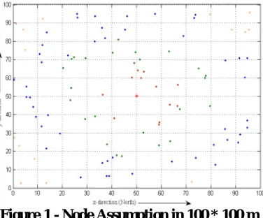
V. SIMULATION AND RESULTS
The simulations for proposed algorithm are done in Matlab. The simulation setup consists of 100 unknown nodes deployed randomly in a field of 100m x 100 m field. Fig. 1 shows 100 nodes divided into hops according to the distance from anchor node at (xi,yi). The red, green, blue and orange dots indicate nodes at 1st, 2nd, 3rd and 4th hop
from anchor
respectively. The anchor node is situated at (50, 50) and is indicated by red. Every sensor node can communicate with other sensors if distance between them is smaller than sensor range. Transmission range for each node is fixed at 18 m. For all possibly communicable nodes, the algorithm for localization comprising implementation process P-1 and P-2. The maximum number of iterations run for each node is only 5, practically the number of iteration may be < 5 for some nodes because of the termination condition given in (c). The localization error for each hop nodes is determined for
different values of variance in angle ( ).
Figure 1 - Node Assumption in 100 * 100 m
Fig. shows the uncertainty locationss after 1st and 5th iteration for all 100 nodes in 4 hops after running 5 iterations of
MAIL with e0=0.5 m and ( )=5 degree. The locations indicated with red, green, blue and orange after 1st
iteration of algorithm for 1st, 2nd, 3rd and 4th hop nodes respectively. Reduced locations for each node after 5th
iteration are shown as black
patches.
ISSN(Online): 2319-8753 ISSN (Print) : 2347-6710
I
nternational
J
ournal of
I
nnovative
R
esearch in
S
cience,
E
ngineering and
T
echnology
(A High Impact Factor, Monthly, Peer Reviewed Journal)
Visit: www.ijirset.com
Vol. 8, Issue 3, March 2019
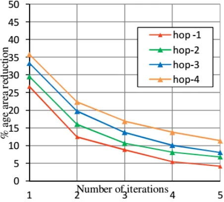
Fig. 3 shows percentage of mean area reduction per iteration for all nodes in each hop from a reference area. The
reference area is of the uncertainty locations formed for a node
at first hop from anchor. Coordinates (xi,yj), of an unknown node are approximated by taking centroid of the remaining region. The estimated locations and actual coordinates are almost overlapping with each other.
Figure 3 – Remaining Locations after Iteration (in %)
VI. CONCLUSION AND FUTURE WORK
The reason to propose this paper is to study about the localization of wireless networks and the error in estimating the method and also the iterations in the localization. The implementation of this method does not require any special software or hardware and computational time is also less. It can be also implemented without beacon nodes. Due to this reason, the cost of implementation is low. The proposed work using MAIL algorithm is the accuracy rate is high either large or small number of nodes. In future, it can be implemented with some other methods and the comparative study can be presented.
REFERENCES
[1] D. Li and Y. H. Hu, “Energy-based collaborative source localization using acoustic microsensor array,” EURASIP Journal on Advances in Signal Processing, vol. 2003, article 985029, 2003.
[2] E. Maşazade, R. Niu, P. K. Varshney, and M. Keskinoz, “Energy aware iterative source localization for wireless sensor networks,” IEEE Transactions on Signal Processing, vol. 58, no. 9, pp. 4824–4835, 2010.
[3] M. G. Rabbat, R. D. Nowak, and J. Bucklew, “Robust decentralized source localization via averaging,” in Proceedings of IEEE International Conference on Acoustics, Speech, and Signal Processing (ICASSP '05), vol. 5, pp. V1057–V1060, Philadelphia, Pa, USA, March 2005. [4] D. Ampeliotis and K. Berberidis, “Energy-based model-independent source localization in wireless sensor networks,” in Proceedings of the
16th European Signal Processing Conference, Lausanne, Switzerland, August 2008.
[5] X. Sheng and Y. H. Hu, “Maximum likelihood multiple-source localization using acoustic energy measurements with wireless sensor networks,” IEEE Transactions on Signal Processing, vol. 53, no. 1, pp. 44–53, 2005.
[6] W. Meng, W. Xiao, and L. Xie, “An efficient EM algorithm for energy-based multisource localization in wireless sensor networks,” IEEE Transactions on Instrumentation and Measurement, vol. 60, no. 3, pp. 1017–1027, 2011.
ISSN(Online): 2319-8753 ISSN (Print) : 2347-6710
I
nternational
J
ournal of
I
nnovative
R
esearch in
S
cience,
E
ngineering and
T
echnology
(A High Impact Factor, Monthly, Peer Reviewed Journal)
Visit: www.ijirset.com
Vol. 8, Issue 3, March 2019
[8] R. Niu and P. Varshney, “Target location estimation in wireless sensor networks using binary data,” in Proceedings of the 38th International Conference on Information Sciences and Systems, pp. 17–19, Princeton, NJ, USA, March 2004.
[9] X. Liu, G. Zhao, and X. Ma, “Target localization and tracking in noisy binary sensor networks with known spatial topology,” Wireless Communications and Mobile Computing, vol. 9, no. 8, pp. 1028–1039, 2009.