Article
Enabling fine-grained scientific citation for GRASS
GIS software modules
Peter Loewe1 *, Vaclav Petras2 , Markus Neteler3 and Helena Mitasova2
1 DIW Berlin, Mohrenstraße 58, Berlin, Germany; [email protected]
2 Center for Geospatial Analytics, North Carolina State University, Raleigh, NC, USA
3 Mundialis GmbH u. Co. KG , Kölnstrasse 99, 53111 Bonn, Germany
1
2
3
4
5
6
7
8
* Correspondence: [email protected]; Tel.: +49-30-897-89-222
Abstract:TheauthorsintroducetheGRASSGISadd-onmoduleg.citationasaninitialimplementation ofafine-grainedsoftwarecitationc oncept.Themoduleextendstheexistingcitationcapabilities ofGRASSGIS,whichuntilnowonlyprovideforautomatedcitationofthesoftwareprojectasa whole,authoredbytheGRASSDevelopmentTeam,withoutreferencetoindividualpersons. The functionalitiesofthenewmoduleenableindividualcodecitationforeachoftheover500implemented functionalities,includingadd-onmodules.Threedifferentclassesofcitationoutputareprovidedina varietyhuman-andmachine-readableformats.Theimplicationsofthisreferenceimplementationof scientificsoftwarecitationforbothfortheGRASSGISprojectandtheOSGeofoundationareoutlined.
Keywords:GRASSGIS;g.citation;softwarecitation;openscience;OSGeo;credit;rewards 9
Introduction of GRASS GIS 30-year-long software development 10
GRASS GIS [1] is a community-driven software project already lasting over three decades with 11
continuous community-driven development and maintenance efforts. Since 1983, the software has 12
continuously evolved and its capabilities have been continuously extended according to the needs of 13
the geospatial community. During this time, code management within the project also evolved: The 14
project used manual source code management from 1983 until 1999, when the Concurrent Versions 15
System (CVS) [2] was introduced for revision control. Since 2007 the code management is based on 16
Apache Subversion (SVN) [3] hosted by OSGeo [4], with migration to Git currently being worked on. 17
While version control, including the tracking of code submissions by individuals, evolved over 18
time, the capabilities of the GRASS GIS software to provide user-sided automated citation have not 19
kept up with the current advances in software citation. A standard GRASS GIS 7.4 installation is only 20
capable to generate a BibTeX citation through the g.version module [5], which credits the GRASS 21
Development Team as authors of the whole GRASS GIS software system. 22
The term GRASS Development Team summarizes the community of individuals which have 23
developed and maintained the GRASS code base in past and at present. Within the team, individuals 24
have been and are taking on varying roles when interacting with the code base, including, but not 25
limited to original developer and maintainer. All roles are significant to the GRASS GIS project and 26
should receive recognition (for both the team and the individual efforts) by due credit when scientific 27
results based on these efforts are published. Since GRASS GIS has been under continuous development 28
for over three decades, for many long established GRASS GIS modules the number of persons involved 29
in code maintance, extension and refactoring already exceeds significantly the number of initial authors. 30
A visual summary and overview of the development activities of the GRASS GIS codebase from 1999 31
to 2013 is showing different authors contributing in different periods of time and to different parts of 32
the code[6]. 33
To acknowledge the efforts that the members of the GRASS Development Team dedicated to 34
specific modules or libraries, it is necessary to extend the GRASS GIS software by code-citation 35
capabilities at the level of the individual functionalities, which are implemented as GRASS GIS 36
modules. 37
Additionally, the development of best practices for software citation, especially metadata 38
management, as currently being driven by communities like FORCE11 [7] or CodeMeta [8] remain to 39
be acknowledged and adopted by the GRASS GIS community. This would allow to give credit to all 40
stakeholders in the GRASS Development Team by state-of-the-art scientific citation practices. 41
The role of the OSGeo Foundation 42
The OSGeo Foundation [9] is an umbrella organisation which serves as a communication platform 43
for a growing number of community driven geospatial open source projects since its founding in 2006. 44
GRASS GIS, which preceded OSGeo by over two decades, was one of the founding projects and has 45
ever since played an active role in shaping and advancing the OSGeo workflows and best-practices. The 46
foundation has established common quality standards and best practices for projects, including social 47
aspects of community governance and communication, but also technical aspects like coding standards 48
and repository management. One central factor is the OSGeo incubation process, which is required 49
for open source projects to become accredited within OSGeo. It is similar to the Apache Foundation 50
graduation process [10], and assesses the maturity of project processes, and their compliance with the 51
values and standards of OSGeo. 52
OSGeo embraces and fosters the paradigms of open source, open data, open standards and open 53
education as the building blocks for open science [11]. The foundation belongs to the signatories of the 54
commitment statement of the Enabling FAIR Data project [12] to enable FAIR data (including scientific 55
software to work with the data) in earth, space and environmental science. OSGeo is commited to 56
extend its support for the FAIR, i.e. findable, accessible, interoperable and reusable, principles [13]. 57
However, software citation remains to be included in the OSGeo best practices. 58
Software development in GRASS GIS 59
While many functions provided through existing GRASS GIS modules have remained unchanged 60
in the perception of the users, the portfolio of functionalities which are provided by the GRASS GIS 61
software continues to grow. Contribution of new functionalities, frequently triggered by science 62
projects, results in additions to the GRASS GIS codebase. This requires a sequence of actions, which 63
are related to code quality and license, access and repository management aspects: The code which 64
implements the algorithm for the new functionality migrates over time from the author’s personal 65
domain (i.e., his or her local computing environment), to the community domain of the GRASS project 66
for code review and long term curation, paralleled by public access in the open access domain. 67
If the functionality provided by the code proves to be significant to the overall project, the code is 68
migrated into the development branch of the GRASS codebase as a core module, to become a part of the 69
next official GRASS release. This migration process is paralleled by iterative code quality assessment 70
and improvement by the project community by public discussion, thorough review, refactoring and 71
documentation according to the quality standards of the GRASS GIS project, in accordance to the 72
best-practices of the greater OSGeo software ecotope. 73
Once a new GRASS module has reached add-on module status, the GRASS add-on discovery 74
functionality provided by the module g.extension [14] to install add-on modules makes it both 75
discoverable and accessible to the global user community, allowing for large-scale reuse, preventing 76
waste of third party resources by redundant re-implementations and also potentially allowing to give 77
credit to the developer(s) by citation. 78
When a functionality has become part of the main branch of the codebase, the task of code 79
maintenance shifts from the original author to the GRASS Development Team. Participation of the 80
mandatory. The implemented functionality will continue to be maintained by the GRASS Development 82
Team even after the original author(s) have left the project. Over time, such well maintained and 83
iteratively updated code can reach levels of structuring and performance beyond the programming 84
skills of the original authors. 85
This is similar to paradox of the ship of Theseus [15], which raises the question, if a wooden boat, 86
which has had all physical parts replaced over time, is still identical to the vessel which was initially 87
laid down. From the perspective of both the users and the GRASS Development Team, this is highly 88
desirable and beneficial to the GRASS GIS project: In analogy to the ship of Theseus, the GRASS GIS 89
project keeps rejuvenating its aging codebase in the face of evolving best practices in Information 90
Technologies (IT) and also extends its tonnages by the growing number of included functionalities. The 91
GRASS code repository ensures that all iterations of the GRASS GIS software (e.g. the many instances 92
of Theseus ship) are kept available for future review and analysis. 93
Reward strategies in Science and Software Communities 94
Scientists, which base their research code on GRASS GIS must decide on a strategy if and how to 95
publish their code. This currently results in conflicts regarding the quality of reward, code maintenance 96
and reuse by others. 97
The first strategy, already described above, involves publishing the code as a new GRASS module 98
in the GRASS GIS code repository. This strategy results in potentially widespread re-use, long-term 99
maintenance and appreaciation by the GRASS community. However, the code author will only receive 100
citation credit for his module if the user and prospective author of a scientific publication using the 101
module undertakes the effort to manually derive a relevant citation from the credits on the module’s 102
manual page. In this case, it is also unlikely that members of the GRASS Development Team who 103
contributed to the code updates ensuring its long term usability, will receive any due credit, as most 104
traditional citation standards do not cover this type of critically important contributions. 105
The second strategy for the code author is to publish his or her novel GRASS-based code in an 106
established scientific repository outside the GRASS GIS code repository, like those listed in the registry 107
of research data repositories [16]. These repositories allow for reliable scientific citation through 108
permanent persistent digital identifiers (PID), like Digital Object Identifiers (DOI) [17] to reference the 109
landing pages, instead of transient URL links to module man pages, as currently used by GRASS GIS 110
and other OSGeo projects. 111
However, from the established long-term expectation for fitness for use by the GRASS community, 112
the second approach must be considered as “dead from the start”: The task to further maintain the 113
code in the chosen scientific repository must be shouldered entirely by the original authors, without 114
the option of the GRASS Development Team to take over at some point. If the original developers 115
will cease to support the maintenance of their submitted code within relatively short time the code 116
archived in the repository will fossilize. Without regular updates the code will lose compatibility with 117
future releases of the GRASS GIS code base and it will need major updates or re-implementations to 118
make it executable in the future. 119
The GRASS GIS g.extension [14] module, which allows to integrate add-on modules to an 120
existing GRASS GIS installation, provides the means to access GRASS add-on code from external 121
code repositories, including RE3Data-listed scientific repositories [16] like Zenodo [18]. However, this 122
requires existing prior knowledge by the prospective user where the particular module is stored and 123
what it does. In addition, it is left to the user to assess the compatibility and trustworthiness of such 124
unmaintained code in regard to the version of GRASS GIS currently being used. Since this applies to 125
each user wishing to reuse the code, this can lead to repeated re-implementations over time. 126
g.citation: Software citation for GRASS GIS modules 127
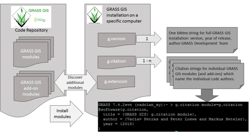
The new g.citation module [19] complements the existing citation capabilities for GRASS GIS 128
Figure 1.Overview of citation options for GRASS GIS: The GRASS GIS module g.version only provides a BibTeX citation string for the whole GRASS GIS installation, citing the GRASS Development Team as author. The new g.citation module can be installed from the GRASS GIS code repository via the g.extension module. It provides citations for individual GRASS GIS modules (and add-ons) in multiple output formats. The BibTeX output of self-referential application is shown in the lower right of the figure.
GRASS modules (Figure1) in an automated and user-friendly way (Figure2). This is a first step to 130
overcome the current limitations of the GRASS GIS software regarding convenient and flexible citation 131
capabilities to encourage users to cite both software and code, and to increase the motivation for code 132
submissions to the GRASS GIS code repository for scientists. While the development of the module is 133
currently in its late experimental phase in the GRASS sandbox code repository [20], it already supports 134
three distinct categories of citation options. 135
The first category are citation strings formatted for human use in a text processor, according 136
to the formatting rules (e.g. Figure3). The second category provides machine readable generalized 137
software metadata such as Citation File Format [21] (CFF) (Figure4). The third category provides well 138
formatted strings as input for reference management software used by humans or computer systems 139
for formatting lists of references including a BibTex style (Figure1) and Citation Style Language 140
output[22] which are to be rendered by reference management tools and CSL-processors into a variety 141
of citation styles, similar to citation rendering services already provided by scientific data repositories 142
and citation infrastructures, as provided through the web portals of Zenodo or DataCite [23]. 143
Next Steps 144
In addition to the improvement and extension of the g.citation module functionality and code 145
quality, several tasks related to the GRASS GIS project and the OSGeo foundation have been identified, 146
which can now be taken on because of the availability of g.citation. 147
The first task concerns the homogenization and improvement of the metadata within the GRASS 148
GIS project: Currently, the quality of code-related metadata provided as human-readable content on the 149
manual pages of GRASS GIS modules is mixed in terms of identifying contributions by individuals and 150
their respective roles (e.g. original authors, maintainers, etc.). While best practices exist, a controlled 151
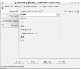
Figure 2.Screenshot of the GUI of the g.citation module, showing the currently included citation style options.
Figure 3.Example output for human readable output adhering to the Chicago footnote citation style, to be used with word processors
defined yet. Additionally, no machine-readable metadata are provided on the module manual pages. 153
This makes it computationally hard to derive well-formed citation strings which now need to be 154
parsed using different heuristics. To mitigate this, the output from g.citation derived from the current 155
GRASS GIS manual pages can be used as input for a clean-up effort to homogenize and improve the 156
structuring of the content of already existing GRASS GIS manual pages: As a follow-up step, it is 157
intended to improve the GRASS GIS-internal code and documentation management workflow by 158
integrating a new layer of structured CFF-files with well-defined metadata attributes as the source for 159
HTML manual pages. This will result in an improved discoverability and scientific credit for content 160
in the GRASS GIS code repository. 161
The second task is to establish code citation capabilities as a best practice for the OSGeo foundation. 162
Once g.citation becomes included into the main branch of the GRASS GIS codebase, GRASS GIS can 163
become a role model within OSGeo for code citation. In a follow up step, OSGeo can elect to include 164
the topic of code citation capabilities and best practices into incubation process check-list. 165
The third task is to evolve the software repositories of OSGeo software projects to meet the current 166
requirements of scientific data repositories and to establish them as recognized scientific infrastructure. 167
This will involve updates on the metadata schemata, inclusion of machine-readable metadata to 168
improve discoverability from outside and replacement of potentially transient (i.e., expected to fail 169
on the very long-term time scale of literature and libraries) URLs with persistent identifiers. Many 170
aspects of the GRASS GIS project infrastructure already comply with these requirements, like the 171
Figure 4. Example output, both human and machine readable, in code citation format to be used for reference management software (used by humans) or as input for machine actionable citation harvesting by entities like DataCite.
the requirements for landing pages for DOI-referenced data sets. The GRASS GIS project could also 173
become the driver for this within OSGeo. 174
Conclusion 175
The GRASS GIS add-on module g.citation extends the existing functionality of GRASS GIS by 176
generating human- and machine-readable citation information for individual GRASS GIS modules. 177
This allows scientists to give the due credit to the respective authors of these individual modules. The 178
new functionality is a pragmatic step towards improvements of workflows and infrastructures within 179
the GRASS GIS project, which can become examples for the greater OSGeo community. Based on 180
this relatively small step, follow up efforts, which can have positive effects on larger scales, can be 181
undertaken to homogenize the quality of metadata within the existing GRASS GIS codebase, establish 182
g.citation as a OSGeo-wide reference implementation, and make code citation capabilities a topic for 183
the OSGeo incubation process. 184
Author Contributions:Conceptualization and Methodology, Peter Loewe, Vaclav Petras, Markus Neteler and 185
Helena Mitasova; Software, Vaclav Petras and Markus Neteler; Data Curation and Funding Acquisition, Peter 186
Loewe; Supervision and Resources, Helena Mitasova 187
Funding:“This research received no external funding.” “The Article Processing Charge (APC) was funded by 188
Society of Friends of DIW Berlin (VdF)”. 189
Conflicts of Interest:“The authors declare no conflict of interest.” “The funders had no role in the writing of the 190
192 Abbreviations
193 Thefollowingabbreviationsareusedinthismanuscript: CFF Citation File Format
CSL Citation Style Language CVS Concurrent Versions System DOI Digital Object Identifier
FAIR Findable, Accessible, Interoperable, Reusable FORCE11 Future of Research Communications
GIS Geographic Information System
GRASS GIS Geographic Resources Analysis Support System IT Information Technology
JSON Javascript Object Notation
OSGeo Open Source Geospatial Foundation PID Persitent Identifier
RE3Data Registry of Research Data Repositories SVN Apache Subversion
URL Uniform Resource Locator 194
References 195
1. GRASS GIS community. GRASS GIS - Bringing advanced geospatial technologies to the world. 196
https://grass.osgeo.org, 2018. [Online; accessed 13-September-2018]. 197
2. CVS Team. Concurrent Versions System. https://en.wikipedia.org/wiki/ConcurrentVersionsSystem, 2018.[Online;accessed13− September−2018].
3.198 Apache Foundation. Apache Subversion. https://subversion.apache.org, 2018. [Online; accessed 13-September-2018].
199
4.200 GRASS GIS community. GRASS GIS Software Repository on SVN. https://svn.osgeo.org/grass/, 2018. [Online; accessed 13-September-2018].
201
5.202 GRASS GIS Development Team. GRASS GIS: g.version module.
https://grass.osgeo.org/grass74/manuals/g.version.html, 2018. [Online; accessed 13-September-2018]. 203
6.204 Neteler, M. GRASS GIS 6.4 development visualization from 1999 to 2013. https://doi.org/10.5446/14652, 2013. [Online; accessed 13-September-2018].
205
7.206 FORCE11 Community. FORCE11 – Future Research Communication and e-Scholarship, 2011. [Online; accessed 13-September-2018].
207
8.208 CodeMeta Project. CodeMeta Website. https://codemeta.github.io/, 2018. [Online; accessed 13-September-2018]. 9.209 OSGeo Foundation. OSGeo Website. https://www.osgeo.org/, 2006. [Online; accessed 13-September-2018]. 10.210 Apache Foundation. Apache Website, 2018. [Online; accessed 13-September-2018].
11. Wikipedia contributors. Open Science — Wikipedia, The Free Encyclopedia. https://en.wikipedia.org/wiki/Openscience, 2012.[Online;accessed13−September−2018].
12.211 Enabling FAIR Data Project. Enabling FAIR Data Project Website. http://www.copdess.org/enabling-fair-data-project, 2016. [Online; accessed 13-September-2018].
212
13.213 Enabling FAIR Data Project. Enabling FAIR Data Commitment Statement in the Earth, Space, and Environmental
Sciences. http://www.copdess.org/enabling-fair-data-project/commitment-to-enabling-fair-data-in-the-earth-space-and-environmental-sciences/, 214
2018. [Online; accessed 13-September-2018]. 215
14.216 Markus Neteler, Martin Landa and Vaclav Petras. GRASS GIS: g.extension module. https://grass.osgeo.org/grass76/manuals/g.extension.html, 2017.
217
15.218 Wikipedia contributors. Ship of Theseus – Wikipedia, The Free Encyclopedia, 2012. [Online; accessed 13-September-2018].
219
16.220 re3data Project. re3data website. https://www.re3data.org/, 2018. [Online; accessed 13-September-2018]. 17.221 DOI community. DOI website. https://www.doi.org/, 2018. [Online; accessed 13-September-2018].
18.222 Zenodo Community. Zenodo research data repository. https://www.zenodo.org/, 2015. [Online; accessed 13-September-2018].
19.224 Petras, V.; Löwe, P.; Neteler, M. GRASS GIS: g.citation module. https://svn.osgeo.org/grass/sandbox/wenzeslaus/g.citation/g.citation.html, 2018.
225
20.226 Petras, V.; Löwe, P.; Neteler, M.; Mitasova, H. GRASS GIS: g.citation preliminary code repository. https://trac.osgeo.org/grass/browser/sandbox/wenzeslaus/g.citation, 2018. [Online; accessed 227
13-September-2018]. 228
21.229 Druskat, S. Citation File Format (CFF) GitHub repository. https://citation-file-format.github.io/, 2018. [Online; accessed 13-September-2018].
230
22.231 CSL team. Citation Style Language Website. https://citationstyles.org/, 2018. [Online; accessed 13-September-2018].
232