Copyright © The Author(s). All Rights Reserved. Published by American Research Institute for Policy Development DOI: 10.15640/jea.v7n1a10 URL: https://doi.org/10.15640/jea.v7n1a10
Sustainable Urban Growth of Neighborhoods-A Case Study of Alryad-Khartoum
Z. E. Awad
1Abstract
Alryad neighborhood is located in Khartoum town– the administrative center of the Capital of Sudan. The neighborhood is one of the high-income residential areas. It was planned and developed in 1972 with large plots (875-600 m2), wide crossing roads and balanced environment. Recently the area shifted to more
compact urban form of high density, it is transformed towards mixed-use integrated development with more intensive use of land and less-residential uses. This transformation affected the quality of the neighborhood and the inter-related features of the built environment. The research problem focused on the challenges of transformation that associated with compact neighborhood and the created multiple urban problems e.g. stress of essential services (water supply, electricity and drainage), congestion of streets and demand for parking. The study analyzed the current situation of the neighborhood compared to the five principles of sustainable neighborhood prepared by UN Habitat. The study found that the process of change of the neighborhood was originated by external forces due to the declining economic situation of the whole country. Non-residential uses have taken place uncontrolled, unregulated and haphazardly that led to damage the residential environment and deficiency in infrastructure. The quality of urban life on levels of privacy was reduced, the neighborhood changed gradually to be a central business district. The results showed that Alryad is not fully sustainable. The recommendation is to guide the possible growth patterns through building and planning codes that accommodate transformations and provide new solutions which allow for promoting the neighborhood sustainable development.
Keywords: Compact neighborhood, Land uses, Residential area, Transformation, Mixed use. 1. Introduction
The issue discussed in this paper related to the concept of the compact city but in a smaller scale, the concern here is the urban and cultural context of the neighborhood because the urban experience of the residents is clear at the neighborhood level (Dembsey [1]).The most prominent features of the compact city are relatively high residential density with mixed land uses, an efficient public transport system and socially and economically diverse. These features are subjective and complex (Dembsey [2]). Benefits of compact or smart urban form are numerous as stated by (Dielmann and Wegener [3]): strengthen urban communities, increase inhabitants of central cities, provide affordable housing, enhance equity and reduce segregation, reduce travel demand and decrease travel distances, encourage walkability and biking, reduce cost of infrastructure such as road, water and sewer infrastructure, protect land farm and green areas and improve health”.
It is clear that mixed land use development is a key feature of compact urban form. It eases everyday life of the neighborhood residents in terms of well-located accessible services. Proximity of uses and integration within wider networks of urban physical, social and economic infrastructures are crucial for successful mixed neighborhood (Foord[4]).land management is improved by reducing the demand for travel because many people are working and living in the same area and there is optimal use of land for both commercial and residential (Dielmann and Wegener [3]).
1 Head Department of Architecture and Physical Planning, Building and Road Research Institute, University of Khartoum-Sudan,
The most important factors of multi-functions use that connected with land-use and transport are: residential
density, employment density, neighborhood design, and accessibility (Dielmann and Wegener [3]). Elaborated urban design at neighborhood and community levels of mixed land-uses, contribute to successful urban
environments. The complex relationships between urban form, function and sustainability can be solved by good design (Dielmann and Wegener [3]).
Considering the private economic benefits of good urban design, (CABE and DETR[5]) found by empirical evidence that good urban design increases the rental value of new development. Good urban design provides some facilities (cafes, shops, pubs, etc.), which attract people and need lower maintenance costs. New developments contribute to the delivery of strong and vibrant communities if full consideration is given to the balance between supporting growth and ensuring communities have the opportunity to influence their environments (Galster[6]).
Furthermore, neighborhood change is proving unpredictable as stated by (The National Archive [7]). Many residential zones within neighborhoods change into commercial or administrative zones a trend that benefits the five distinctive types of users: households, businesses, property owners, local governments and most properly the visitors (Kearnsand Parkinson[8]).
As stated by (Galster[9]), neighborhood is a bundle of spatially based attributes associated with clusters of residence and other land uses. These attributes are associated with buildings, infrastructures, characteristics of inhabitants and sometime topography. The combination of all these attributes together produce the specific type and quality of the neighborhood. Therefore, any change occurs to one attribute would ultimately affect the classification of the neighborhood. Quality of the neighborhood can be tested by inter-related and inter-dependent features of the built environment. Some of these features are high residential density, mixed land uses, accessibility, connectedness and permeability, legibility, attractiveness, inclusiveness, maintenance, safety, and character ( Dempsey[10]).
Urban changes create new multifold challenges for cities such as: deficiencies in infrastructures, heavy cost of inappropriate policies, and financial and technical weaknesses of local institutions. All these challenges are important constraints, whose cumulative effects drain the potential for progress(Mega[11]).
At the regional context, urban growth in Africa has led to transformation in some cities e.g. some residential areas in Kampala are turning into commercial hubs to avoid transportation difficulties in the city center (Ngwomoya[12]). The growth of Dhaka city more than six times bigger than the old city have led to the transformation of Dhanmondi neighborhood towards more intensive use of land, multi-storied apartments and non-residential uses ( Afrin et al[13]).
2.Sustainable neighborhoods
Some scholars analyzed the performance of urban forms in relation to sustainability. Jabareen[14] formulated a sustainable urban form matrix to assess sustainability of different urban forms according to seven design concepts. The identified seven design concepts related to sustainable urban forms are: compactness, sustainable transport, density, mixed land uses, diversity, passive solar design, and greening. The results showed that the compact city contributes more to sustainability than other urban forms. He concluded “The ideal sustainable urban form is that which has a high density and adequate diversity, compact with mix land-uses and the design is based on sustainable transportation, greening and passive solar energy”. While Sharmin[15] recognized eight key issues to achieve a sustainable urban form which included compact and mixed-use development, high density, social wellbeing, design excellence, renewable energy sources, sustainable built environment, efficient transport network and preservation of open space and ecosystems. Dave[16] argued that high density model would contribute to sustainability in neighborhoods if policy makers support. Williams [17] raised two important issues when applying urban intensification in achieving sustainability:
-How to control development to support objectives of sustainability.
-How to manage development to maximize benefits of intensification and minimize its negative impacts.
The urban form with high density contributes to small networks and strong social interactions between residents compared to low density residents widely spread social networks and activities with very few strong relationships (Raman[19]). Moreover, the design of compact, sustainable housing has effects on privacy in the home.
Lindsay et al [20] studied the effects of specific design features at the dwelling scale that contribute to the dwelling
perceived privacy. The results suggested that in certain types of dwellings, such as flats, noise from neighbors is heard more often. It is known that privacy well achieved in detached house type that well set back from the street.
The three key features of sustainable neighborhoods and cities are: compact, integrated and connected. UN Habitat has developed five principles as a new strategy for sustainable neighborhood planning (UN Habitat [21]). These principles are:
1. Adequate space for streets and an efficient street network: The street network should occupy at least 30 per cent of the land and at least 18 km of street length per km².
2. High density: At least 15,000 people per km², that is 150 people/ha or 61 people/acre.
3. Mixed land-use: At least 40 per cent of floor space should be allocated for economic use in any neighborhood. 4. Social mix: Availability of houses in different price ranges and tenures to accommodate different incomes; 20 to
50 per cent of the residential floor area should be for low- cost housing; and each tenure type should be not more than 50 per cent of the total.
5. Limited land-use specialization: single function blocks should cover less than 10 per cent of any neighborhood. 3. Research Methodology
A case study approach was chosen to gather the necessary qualitative and quantitative data. a detailed survey on existing development pattern was carried out over the whole area of Alryad,100% of the plots of the area were surveyed focusing on building types. Data on the built and social environment of the neighborhoods were collected through observations, interviews and secondary data sources. The assessment of sustainability of the neighborhood was based on the empirical findings of the field work compared with UN Habitat principles of the sustainable neighborhood. The research focused on the transformation of the neighborhood connected to the structural characteristic of the residential and non-residential buildings and infrastructures.
4. Description of the neighborhood
Alryad neighborhood is located in Khartoum town– the administrative center of the national capital of Sudan. Khartoum city is also the capital for Khartoum State, one of 18 Sudanese states. Khartoum State area is 22.142,000 km2 and its population has grown to 7,687,547 (https://wikivisually [22]). Location of the neighborhood is
shown in figure (1) and (2).
Figure (1): Location of Alryad neighborhood Figure (2): Alryad neighborhood
The neighborhood was planned in two phases, the first phase was planned in 1972, it comprises 1477 plots of first and second-class residential areas, distributed to senior governmental officers. The second phase was added in 1982 with a different planning pattern, it comprises 444 plots, (Khartoum State [23]).
The neighborhood has a squarish form, its total area is 1600m x1750m about 2,800,000 m2and the inhabitants
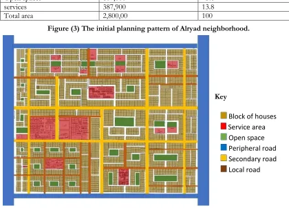
are about 12,797 people (Khartoum State [23]). The planning pattern is grid iron with intersecting roads. The initial service area is located at the center of the neighborhood with slight shift to the western side. The areas of different land uses are presented in table (1) below and their locations are shown in figure (3).
Table (1) land -uses of Alryad
Land -use Area(m2) % of the total area
Plots 1540,000 55.0
roads 765.380 27.4
Open spaces 107,000 3.8
services 387,900 13.8
Total area 2,800,00 100
Figure (3) The initial planning pattern of Alryad neighborhood.
Key
Source: Archive of Ministry of Physical Planning 5. Discussion
5.1 Buildings:
Alryad neighborhood was planned as a residential area with villa type development of low-density. Recently the area shifted to more compact urban forms through the development of multi-storied structures of high density. Although the neighborhood is not defined by location as an inner-city residential area but it experienced changes that occur to such places It is evident that the process of change of the neighborhood was originated by external forces due to the declining economic situation of the whole country and still continue due to absence of policy control. The most important socio-economic process in the neighborhood has been the commercialization and deinitialization of the area in connect with the displacement of the residential function. Transformation in neighborhoods can be seen by the structural characteristics of the residential houses ( Al-Said[24]). In Alryad neighborhood, houses passed through three distinctive stages:
Block of houses Service area
-The villa stage: The villa was built in the residential plot respecting building regulations of set- backs. In most cases,
there was a garden at the front part of the plot facing the street. The house was occupied by the family. -The villa expansion stage: More floors were added to the building to accommodate new families and thus increased
the number of inhabitants and the demand of services. Or the initial family left and the whole building used for non-residential uses e.g. an embassy or a bank.
-The villa annex building stage: A new expansion was built at the front of the plot in the garden area, the new expansion could be used as a shop, a chemist, a saloon or any other commercial or administrative use. (see fig (5)).
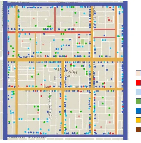
Some vacant plots within the neighborhood were developed recently with multi-floors structures to be used as flat complexes or office buildings. Most of these buildings were located along main streets, figure (4) shows locations of these buildings within the neighborhood and figure (6) shows an example of a multi-floor building.
Figure (4) Distribution of multi-floors buildings within the neighborhood.
Key:
Source: Field Survey March-September 2018
Figure (5): The villa annex building is used as furniture shop Figure (6): A multi-floors office building
Source: Field Survey November 2018 Source: Field Survey November 2018
Blocks of houses Multi-floors Buildings
Service area
Open space Peripheral road
In contrast to (Mega [11]) argument that new construction of high-quality dwellings in excess of household demand rendered the array of lower quality neighborhoods relatively less attractive and less expensive, the new developments in the neighborhood changed the residential use into commercial and administrative uses. The distinctive four types of users benefit from this change of land uses are:
-households who occupy residential units benefits from nearby surrounding services
- businesses occupying non-residential structure (restaurant, clinic, office, etc.) gain profit by selling services. - property owners gain profit from renting their buildings or lands.
- local governments extract tax revenue from owners of residential and non-residential buildings. 5.2 Social Services
Obviously, social infrastructures need to be adaptable and responsive to changing educational, health, social and economic needs of the inhabitants. Provision of social services has to consider the following key elements
(Brown,.and Barber[25]):
- Scale : The existing and proposed facilities in the nighbourhood and the surrounding areas. - Local context: People living in the area and their need and accessibility challenges.
- Building in flexibility: Socio-demographic changes and their impact on the need.Possibility of co-location of services. - Long-term governance arrangements: Management, financial and ownership arrangements
Regarding Alryad neighbourhood all the above mentioned key elements are changed. Moreover, the provision of social infrastructure should be appropriate at a number of spatial levels from neighbourhood to city . Each social service has its service zone,e.g.schools serve neighbourhoods residents while college or university serve cities residents . Obviosly, services and infrastructures development as stated by ( Steinführer [26]) depend on administrative decision and private investment in addition to demand. In the case of Alryad neighbourhood, private investment and demand
are the main reasons for provision of social services without considering the important role of administrative decision. There is a huge difference between the initial proposed social facilities by the planning authorities (see figure (3) and
the type and number of the existing social services that is listed in table (2) and their location within the neighbouhood is presented in figure (7). The field servey revealed that provision of social services ( their numbers and level of service) in the neighbourhood is more than the need of the inhabitants ,so that they draw in people from neighbouring areas.They serve a wider spatial context than the neighbourhood itself,which is vital to long-term sustainability.Some social services e.g.basic shools serve in addition to the neighbourhood inhabitants , nearby neighbourhoods-El taif,Naser Extention or Elgeraif .While resturants and cafes serve a wider range of inhabitants of khartoum town. It is noticable that most of social services -especially the commercial services - are located along the main streets to serve more people out side the neighbourhood ,while schools are located inside the neighbourhood near open spaces to extend out-door activities in open spaces.
Interstingly,the development of the neighbourhood influence nearby third class residential areas-Nasir extension and Algeraif .Most of social services located along the perepherial streets extended on both sides ,so improving the quality of nearby areas.
Table (2) Existing social facilities in Alryad neighbourhood.
Social Facilities Number Social Facilities Number
Commercial facilities Health-care Facilities
Supermarkets 10 Dentists 10
Electronics 11 Clinic 17
Hair Salons 15 Hospital 3
Retail Stores 111 Educational Facilities
Car Service 15 Nurseries 8
Pharmacy 14 Schools 27
Bakery 5 College 14
Real Estate 8 Training Centres 18
Furniture 3 Administrative Facilities
Others 40 Company 116
Food & Drinks Embassy 7
Restaurants 49 Bank 9
Coffee Shops 15 Recreational Facilities
Juice Bar 6 clubs 5
Religious Facilities Wedding hall 1
Mosque 11 Developed open spaces 3
Religious center 2 Hotels 4
Figure (7) Location of Existing Social facilities. Source: Field Survey March-September 2018
Source: Field Survey March-September 2018
5.3 Sustainability of Alryad neighbouhood 5.3.1 Streets network Characteristics:
The total area of the streets is 765.38 m2 which represents 27.4% of the total area of the neighborhood. The
area of streets is sufficient according to UN Habitat principles of the sustainable neighborhood. The distance between two adjacent streets in the neighborhood is 80 – 100 m which is near to the recommended distance: 100 – 150 m. The distance between two arterial streets is 200 -1000 m which is within the recommended range: 800 -1,000 m. The total streets length per km2 in the neighborhoods is 16.6 km which is less than the recommendations: 18.0 km. All
peripheral streets and internal streets of the neighborhood are paved. The street hierarchy with arterial routes and local streets is highly interconnected. Public transport is available on the peripheral streets. Table (3) summarizes characteristics of the streets network of the neighborhoods.
Table (3) Characteristics of the streets network of the neighborhoods
Characteristics of streets network Alryad neighborhood The sustainable neighborhood
% Total area of streets 27.4% 30%
Total street length per km2 16.6 km 18.0 km
distance between two arterial streets 200-1000 m 800 -1,000 m distance between two adjacent streets 80-100 m 100 – 150 m Walking distance to service center Less than 200 m 400-450 m
Mini-bus catchment area radius 600 m 320-640 m
Regarding urban mobility, the neighborhood has good transport connectivity with other parts of the capital. It is accessible by private mini- buses used as public transportation and private cars and within neighborhoods by Ructions. Unfortunately, there are no special roads within the neighborhood dedicated for bicycles or pedestrians only that is against the sustainable mobility. Some inhabitants plant trees in front of their houses so that some streets are shaded. All streets within the neighborhood encourage walkability and reduce car dependency for the inhabitants. The neighborhood encourages public transport hence the walking distance to bus stations; catchment area for mini-buses is 600 m which is acceptable according to the recommended distance by UN Habitat -320 to 640 m. Walkability in the neighborhood is good as the walking distance to key services is less than 200 m, thus it has good walkability according to the recommendation of UN Habitat - 400 to 450 m.
Key:
religious facilities health facilities administrative facilities
educational facilities commercial facilities
5.3.2 Density: Sudan as a sub-Saharan African country has a low density of 24 persons per sq.km (http://www.worldometers [27]). The Residential density of the neighborhood is 4,620 person/ km2 which is higher
than the average density of khartoum city-347 person/ km2 (https://wikivisually [22]). Unfortunately it is less than the
recommended density of the sustainable neighborhood -15,000 person/ km2. On the other hand, employment density
is very high since the numerous facilities and services provided in the neighborhood employed a lot of number of people. Most of these employees don’t live in the neighborhood because they couldn’t afford the housing cost. They live in nearby third-class residential areas e.g. Naser extention and Elgerif.
5.3.3 Mixed land-uses: Many buildings in the neigbourhood have more than 40% of floor area dedicated for commercial or administrative use.Moreover, several buildings used total floor area for non- residential use e.g. a bank.an embassy or a hospital. The mixed developments found in the neighbourhood are more than the reccommendations of UN Habitat. Obviousely, the mixed developments support and promote street life and a single function neighborhood has been converted into a vibrant multi-functional community.
5.3.4 Social mix: There are different types of houses in the neighborhood: villas and flats with different tenures: ownership or rent to accommodate different family types and sizes. Unfortunately there is no social mix of different income levels as the majority of the inhabitants have high income . Most probably, absence of social mix reduces the social sustainability in the neighborhood.
5.3.5 Limited land-use specialization: Although, there are a lot of mixed land-uses along the main streets but there are many blocks located inside the neighborhood used for residential purpose only. Unfortunately, single function blocks cover more than 10 per cent of the neighborhood.
5.4 Growth Challenges
Alryad neighborhood transformed to a compact, multi-functions neighborhood. The important question is: Does the planning of the neighborhood tolerate that transformation in terms of street network, provision of basic services (electricity, water, drainage.) and parking. Unfortunately, the transformation of the neighborhood into more compact and multi-use development contradicts the main concept of Perry’s neighborhood - a social unit of neighbors. The social connection between inhabitants became weak and the residents lost the sense of belonging to their neighborhood hence so many strangers strolling around. Although the quality of urban life regarding provision of facilities and services was promoted, but it was reduced in particular on levels of privacy. The neighborhood changed gradually to be a central business district that provides services to the whole Khartoum town. Moreover, the neighborhood suffers lack of public and green spaces. The total number of open spaces is 31 with a total area of 107,000 m2 which represents only 3.8% of the neighborhood total area. It is less than the international standard of
15% of land should be allocated to open spaces, green spaces and public facilities (UN Habitat [28]). Alryad index of sufficiency of open spaces is 8.7 m2 which is so close to the international standards -a minimum of 9 m2 per person,
but developed open space index is only 1.2 m2 which is very low (World Health Organization [29]).
It is clear that the neighbourhood changes, create new multifold challenges and many problems which include but not limited to:
- Noise pollution -disturbance from noise especially at evenings. -loss of privacy. -traffic, congestion, and accidents.
-limited parking provision at day for administrative use and by night occupied for eating, drinking and leisure facilities. -limited open spaces.
-Infrastructures are over loaded. Having large number of users of services put pressure on physical infrastructures and may lead to disasters.
The above mentioned problems are important constraints, whose cumulative effects drain the potential for progress.
Although change is inevitable, the important question is how best to manage this change. Local planning authorities can monitor, guide and control land uses development in residential areas. As stated by (Bureau of development and services [30]) zoning regulations might:
- Govern sizes and shapes of buildings.
- Set controls on planting street trees under certain circumstances. - Specify how late a business can remain open at night.
6. Conclusion
The debate over controlling urban sprawl in Khartoum State took a long time. Most Sudanese urban areas are characterized by massive horizontal sprawl that results in wasteful land uses and long expensive infrastructure (Ministry of Environment, Forestry and Urban Development [31]). Policy makers in Khartoum State pay attention to compact city concept through densification of parts of the town especially areas along main streets. Although they changed bylaws to allow buildings in neighborhoods along main roads to extent vertically up to 7 storeys, but still set back regulations of built areas are wasting about 30% of the plot area. Furthermore, multi-family housing units should be encouraged and propagated at the expense of single-family housing (Ministry of Environment, Forestry and Urban Development [31]).
Alryad neighborhood is a good example of a compact urban area. The study identified the most prominent features of compact form as high residential density with mixed land uses. The study showed that Alryad is not fully sustainable and self-contained. The assessment of the neighborhood according to the five principles of sustainable neighborhood revealed that street network characteristics and mixed land-uses development are compatible with principles of sustainability. The total area of streets represents 27.4% of the total area of the neighborhood. Residential density is 4,620 person/ km2 which is lower than the recommendations and the limited block land-use
specialization is higher than the recommendations. Most inhabitants have high income so that there is no social mix in the neighborhood.
The uncontrolled development of the neighborhood generates many problems related to provision of basic services (electricity, water, drainage.) and parking. The challenge is to guide the growth of the neighborhood and at the same time maintain the economic, social and environmental aspects of sustainability. The inevitability of transformations, as supported by the case-study, should be controlled. The recommendation is to guide the possible growth patterns through building and planning codes that accommodate transformations. Thus, based on physical factors like location and building use, proposals should envisage growth and change of use initiated by the inhabitants. This will take awareness of the likely infrastructure expansion demands for the likely population. The planning and building codes should thus permit this flexibility.
Planning authorities must organize the neighborhood into zones. For each activity or use of land in any given zoning area, the Code states if that activity or use is either: Permitted; Conditional; or Not Permitted. Therefore, knowing the zoning area of specific property will help identify what specific limits may apply.
7. References
Dembsey, Nand Junks,M.The Future of the Compact City. Built Environment. Volume 36, Number 1, 30 March2010., pp. 116-121(6).
Dempsey, N. Are good-quality environments socially cohesive? Measuring quality and cohesion in urban neighborhoods. Town Planning Review, (2009) 80, pp. 315-345.
Dielmann,F. and Wegener,M. Compact City and Urban Sprawl. BUILT ENVIRONMENT. 2004. VOL 30 NO 4. pp308-323.
Foord.J. Mixed-Use Trade-Offs: How to Live and Work in a Compact City Neighborhood. Built Environment. Volume 36, Number 1, 30 March 2010, pp. 47-62(16).Publisher: Alexandrine Press.
CABE and DETR. The value of urban design. Thomas Telford. Great Britain.2001.
Galster, G. "On the Nature of Neighbourhood", Urban Studies, (2001) Vol. 38 No. 12, pp. 2111-2124.
The National Archive-Department of communities and local governments. How change of use is handled in the planning system-tell us what you think. Issues Paper. (2011). London.
Kearns, A. and Parkinson, M. "The Significance of Neighbourhood", Urban Studies, (2001) Vol. 38 No. 12, pp. 2103-2110.
Dempsey N. Quality of the Built Environment in Urban Neighborhoods Planning Practice and Research(2):249-264 · May 2008.
Mega, V. Urban Dimension of Sustainable Development. Human Settlement Development - Vol. IV
Ngwomoya A. How city residential areas are turning into commercial hubs. Daily Monitor 25. Friday July 14 2017. AfrinS,Zerin I ,Sharmen S and Morshed K. Transformation of Dhanmondi Residential area -Causes, Effects and
Proposal to rejuvenate ,Asian journal of applied Science and engineering .(2012) Volume 1, No.2.pp31-47. JabareenY.R. Sustainable Urban Forms Their Typologies, Models, and Concepts. Journal of Planning Education and
Research 26:38-52 DOI: 10.1177/0739456X05285119 © 2006 Association of Collegiate Schools of Planning. SharminT. A Comparative Study of Sustainable Urban Forms: Compact City and Short Cycle Strategy. AIUB Journal
of Science and Engineering.10 (1).2011.
Dave, S . High Urban Densities in Developing Countries: A Sustainable solution. Built Environment. Volume 36, Number 1, 30 March 2010. pp. 9-27(19).
Williams, K. Does Intensifying Cities Make Them More Sustainable? in Williams, K., Burton, E. and Jenks, M. (eds.) Achieving Sustainable Urban Form. London: E & FN Spon. (2000).
Bramley, G., Dempsey, N., Power, S. Brown, C. and Watkins, D. Social Sustainability and Urban Form: evidence from
British cities. Environment and Planning A, (2009) 41, pp.2125-2142. Raman, S .Designing a Livable Compact City: Physical Forms of City and Social Life in Urban Neighborhoods.Built
Environment. Volume 36, Number 1, 30 pp. 63-80(18).
Lindsay, Morag; Williams, Katie; Dair, Carol. Is There Room for Privacy in the Compact City? Built Environment.2010. Volume 36, Number 1, 30 March 2010, pp. 28-46(19).
UN Habitat. A new strategy of sustainable neighborhood planning: Five Principles. Discussion note 3. Urban Planning.2014. Retrieved from http://www.unhabitat.org.
https://wikivisually.com/wiki/Khartoum_%28state%29#References. accessed 14/11/2018. Khartoum State. Governmental Reports-Khartoum. Khartoum State.2015.
Al-Said, F. A. M. (2003) The formation and transformation of the Traditional Arab-Muslim Neighbourhood: The case of Dammam city, Saudi Arabia, Proceedings of Al-Azhar 7th International Conference, Cairo, Egypt.
Brown,J.andBarber,A.Social infrastructure and sustainable urban communities.Engineering Sustainability.(2012) Volume 165 Issue ES1.pp 99–109.
Steinführer A, Kabisch S, Grossmann K. Residential Change and Demographic Challenge: The Inner City of East Central. Science. edited by Anthony O'Sullivan, Kenneth Gibb, Anthony O'Sullivan, Kenneth Gibb - 2008 - Housing Economics and Public Policy. Business & Economics.
http://www.worldometers.info/world-population/sudan-pop ulation/ accessed 14/11/2018 UN Habitat, Habitat III issue papers 11 – Public Space, New York.2015.
World Health Organization. Health Indicators of Sustainable Cities- Initial findings from a WHO Expert Consultation: 17-18 May 2012.
Bureau of development and services. Change of use or occupancy-30. City of Portland, Oregon www.portlandoregon,gov/bds.Planning Department. accessed 16/11/2018.